| Pages:
1
2 |
mtgoat666
Platinum Nomad

Posts: 21150
Registered: 9-16-2006
Location: San Diego
Member Is Offline
Mood: Hot n spicy
|
|
Quote: Originally posted by 4x4abc  | best hike in San Ignacio is up the Camino Real in the south-east corner of town (700 meters from La Huerta)
one of the best looking stretches of Camino Real
27°16'40.64"N, 112°53'41.81"W
|
Got a kml file of the ecr trail route north and south of San Ignacio?
Woke!
Hands off!
“Por el bien de todos, primero los pobres.”
“...ask not what your country can do for you – ask what you can do for your country.” “My fellow citizens of the world: ask not what America
will do for you, but what together we can do for the freedom of man.”
Pronoun: the royal we
|
|
|
4x4abc
Ultra Nomad
Posts: 4456
Registered: 4-24-2009
Location: La Paz, BCS
Member Is Offline
Mood: happy - always
|
|
here is a small selection - there are many more
Attachment: cr.kml (28kB)
This file has been downloaded 313 times
Harald Pietschmann
|
|
|
David K
Honored Nomad
Posts: 65586
Registered: 8-30-2002
Location: San Diego County
Member Is Offline
Mood: Have Baja Fever
|
|
Entire El Camino Real from Loreto to El Rosario, researched on foot, and plotted on Google Earth: www.caminorealbaja.com
We have discussed this on Nomad. The link is also on my site www.vivabaja.com .
|
|
|
JZ
Select Nomad
Posts: 14910
Registered: 10-3-2003
Member Is Offline
|
|
From that site. That's a gold mine of info.
Attachment: ECR Wpts. 6-22-18.kmz (105kB)
This file has been downloaded 371 times
[Edited on 1-20-2020 by JZ]
|
|
|
David K
Honored Nomad
Posts: 65586
Registered: 8-30-2002
Location: San Diego County
Member Is Offline
Mood: Have Baja Fever
|
|
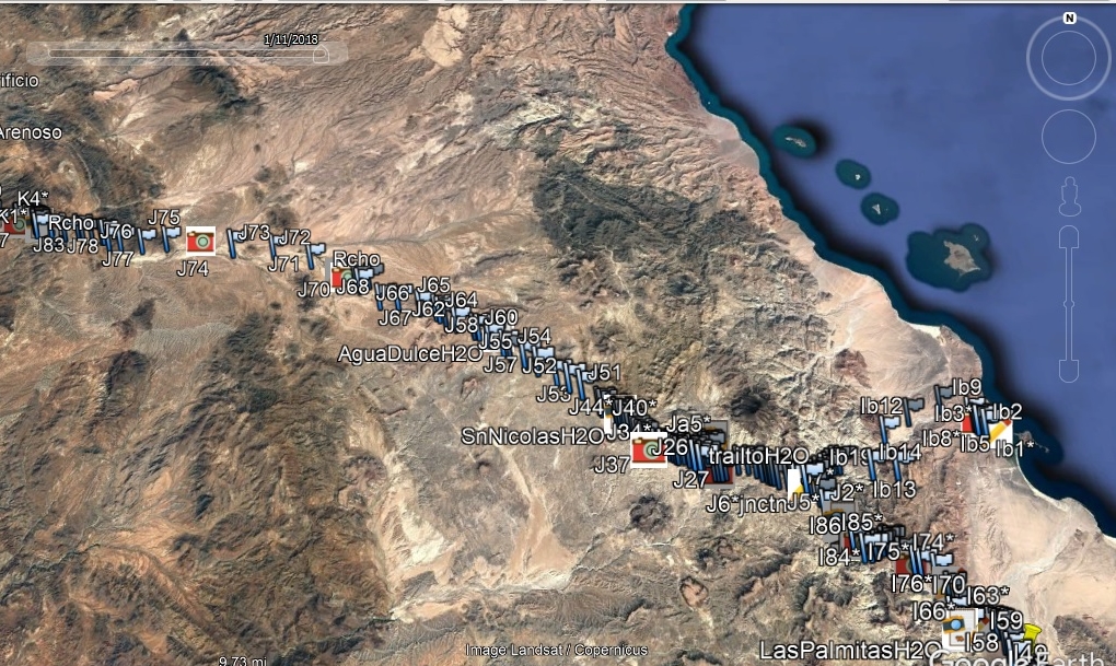
Yes, it is... the creators also have many photos taken along the way, just click on the camera icon.
To use the site, once on Google Earth, you do need to spread the timeline bar tabs apart to see all of the waypoints... This couple really did a ton
of work!
You zoom in to see more detail... This view is showing the trail markers from Mission Santa María to Mission San Fernando. They also include the
Serra Cargo Trail (aka Antelope Trail) from Gonzaga Bay up to the Camino Real junction, 3.5 miles northbound from Mission Santa María.
|
|
|
1Bajalover
Nomad
Posts: 198
Registered: 1-30-2011
Member Is Offline
Mood: UP
|
|
San Ignacio Places to Stay
WOW!!
You all are wonderful - I love this site!
I/we went ahead and
booked a room at La Huerta and will try the food as well -
is that hiking trail easy enough to spot?
|
|
|
| Pages:
1
2 |


