Taco de Baja
Super Nomad

Posts: 1913
Registered: 4-14-2004
Location: Behind the Orange Curtain, CA
Member Is Offline
Mood: Dreamin' of Baja
|
|
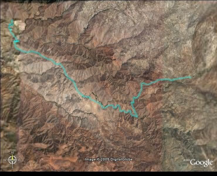
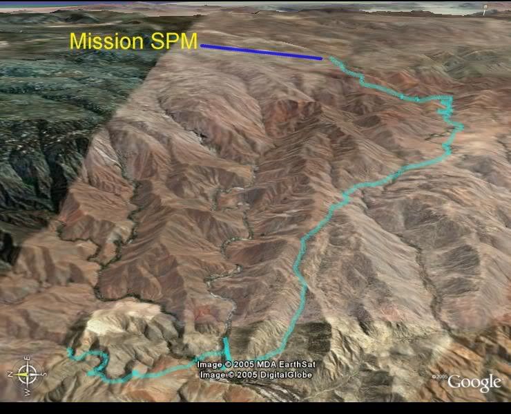
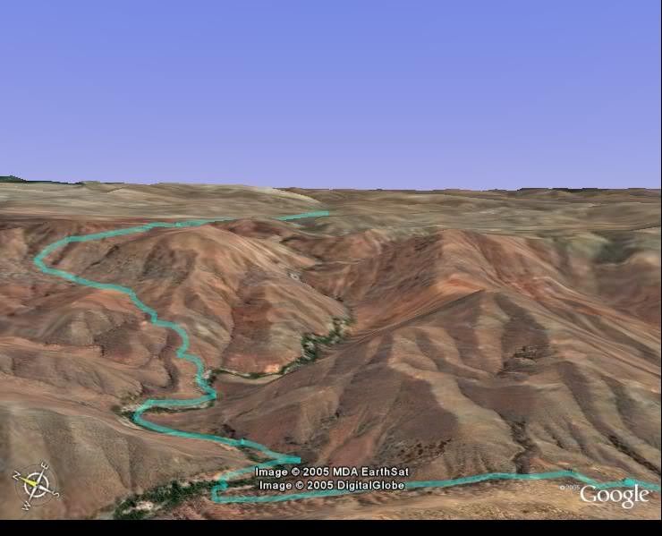
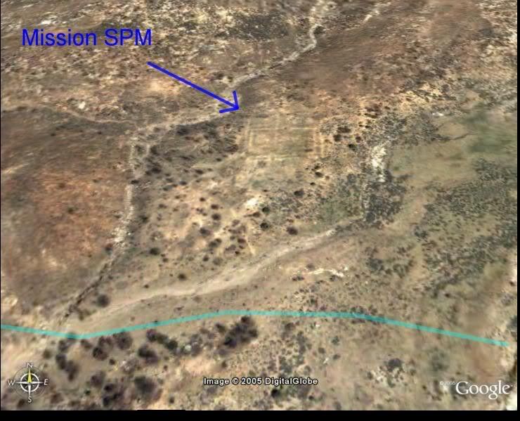
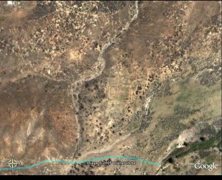
Mission San Pedro Martir on Google Earth
As many of you remember Jack Swords led a hike into the remote San Pedro Martir Mission in April 2004 that I was lucky enough to be on. It was
grueling, but well worth it. I have finally been able to get the GPS points off my old computer, and upload them to Google Earth. The entire trail
happens to be on high-resolution aerial photos and the mission ruins are visible when you zoom in! Even the tree we camped under at the end of the
trail shows up.
I have attached several images below, and have labeled key points on some of the images. Google Earth still blows me away every time I use it.
Enjoy
Oblique view to the north of trail.
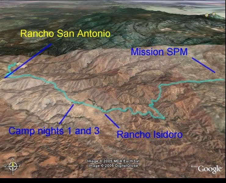
Overhead view of the trail
Oblique view to the north of trail
The steep palisades
Oblique view of Mission ruins
Overhead view of Mission ruins
|
|
|
Barry A.
Select Nomad
Posts: 10007
Registered: 11-30-2003
Location: Redding, Northern CA
Member Is Offline
Mood: optimistic
|
|
Wow-----------
Taco, that is incredible! Wild and wooley place.
Thanks for posting this.
|
|
|
comitan
Ultra Nomad
Posts: 4177
Registered: 3-27-2004
Location: La Paz
Member Is Offline
Mood: mellow
|
|
At the mission SPM you can see squares, which were probably for growing crops..
Strive For The Ideal, But Deal With What\'s Real.
Every day is a new day, better than the day before.(from some song)
Lord, Keep your arm around my shoulder and your hand over my mouth.
The sincere pursuit of truth requires you to entertain the possibility that everything you believe to be true may in fact be false
|
|
|
Jack Swords
Super Nomad
Posts: 1097
Registered: 8-30-2002
Location: Nipomo, CA/La Paz, BCS
Member Is Offline
|
|
Comitan:Actually the squares are walls of the mission (or what is left). Very visible from this photo and on the ground. We were lucky in that a big
fire burned off all of the usual brush that covered the site (also allowed us to take a different trail since the brush was gone.)
Taco de Baja: good job! This would be an interesting way to locate other sites of visitas and old trails throughout this region. Thanks for doing
this. I picked up and saved all of them from the Photobucket site. What a great way to highlight a trip.
|
|
|
bajalou
Ultra Nomad
Posts: 4459
Registered: 3-11-2004
Location: South of the broder
Member Is Offline
|
|
Good work on the tracks with Google Taco - GoogleEarth really is amazing

No Bad Days
\"Never argue with an idiot. People watching may not be able to tell the difference\"
\"The trouble with doing nothing is - how do I know when I\'m done?\"
Nomad Baja Interactive map
And in the San Felipe area - check out Valle Chico area |
|
|
BAJACAT
Ultra Nomad
Posts: 2902
Registered: 11-21-2005
Location: NATIONAL CITY, CA
Member Is Offline
|
|
SPM MISSION
So remote and so beautifull scenery, makes you wounder why they pick such a far away site for the mission.great 411 taco de baja
|
|
|
David K
Honored Nomad
Posts: 65535
Registered: 8-30-2002
Location: San Diego County
Member Is Offline
Mood: Have Baja Fever
|
|
Great stuff Brooks!
To see and read more on Mision San Pedro Martir, photos by Jack Swords and the first version maps by Taco de Baja, go to: http://www.vivabaja.com/bajamissions/page12.html

[Edited on 11-28-2005 by David K]
|
|
|
ursidae69
Nomad
Posts: 275
Registered: 2-22-2004
Location: Youngsville, NM
Member Is Offline
|
|
Hella freakin cool Taco de Baja! 
[Edited on 11-28-2005 by ursidae69]
|
|
|
John M
Super Nomad
Posts: 1924
Registered: 9-3-2003
Location: California High Desert
Member Is Offline
|
|
The hike
Taco - what was the distance of the hike in miles? How many hours on the trail each day?
John
|
|
|
David K
Honored Nomad
Posts: 65535
Registered: 8-30-2002
Location: San Diego County
Member Is Offline
Mood: Have Baja Fever
|
|
Until Taco de Baja gets back to you, here is what I have from them... posted on my mission page ( http://www.vivabaja.com/bajamissions/page12.html )
Mision San Pedro Martir Trail Details
GPS map datum is NAD27 Mexico
a) Trail Head: 30?49.974', 115?37.718' elev. 2,710' (4 mi. so. of Santa Cruz)
b) Rancho San Antonio: 30?49.004', 115?37.643' elev. 1,934'
__Rio Horno (campsite): 30?46.422', 115?33.875' elev. 2,833'
c) San Isidoro: 30?45.905', 115?32.745' elev. 2,982'
__Base of Palisades: 30?46.337', 115?31.010' elev. 3,407'
__Top of Palisades: 30?47.073', 115?30.130' elev. 4,917'
d) Mision San Pedro Martir: 30?47.395', 115?28.268' elev. 5,092'
Hiking Time & Estimated Trail Distance (plus direct line on map distance)
a to b : 1 hr., 2 miles (1.1 mi.)
b to c : 4 hrs., 8 miles (6.0 mi.)
c to d : 7 hrs., 10 miles (4.9 mi
|
|
|
Taco de Baja
Super Nomad
Posts: 1913
Registered: 4-14-2004
Location: Behind the Orange Curtain, CA
Member Is Offline
Mood: Dreamin' of Baja
|
|
David covered the times and distances.
The portion from the "camp nights 1 and 3 (Rio Horno)" to the mission was one of the toughest hikes I have ever done. (The Grand Canyon hike where I
whet from the South Rim to the Colorado and back to the South Rim in one 6 hour period was tougher- but I did not have a pack then  ) Not only did we have to brush whack through the canyon bottoms, we had to search for
stream crossing where we would not get wet feet. Our guides were on horses, so they had it easy. We also had to spend time searching for the trail as
well in some areas. If we did not have guides, we never would have made it. ) Not only did we have to brush whack through the canyon bottoms, we had to search for
stream crossing where we would not get wet feet. Our guides were on horses, so they had it easy. We also had to spend time searching for the trail as
well in some areas. If we did not have guides, we never would have made it.
We also had radical elevation changes. And when you set your mind to going up in elevation and think you are gaining, and all of a sudden the trail
begins descending and you know you will just go up again..... We also had rain to contend with. As well as 45 pound pack, on some of us.
For the write up immediately after the hike go here
[Edited on 11-29-2005 by Taco de Baja]
|
|
|
academicanarchist
Senior Nomad
Posts: 978
Registered: 9-7-2003
Member Is Offline
|
|
SPM Mission
The location of the mission explains why it did not last very long, and was the first of the Dominican missions in La Frontera to be abandoned.
|
|
|
academicanarchist
Senior Nomad
Posts: 978
Registered: 9-7-2003
Member Is Offline
|
|
SPM Mission
|
|
|
rpleger
Super Nomad
Posts: 1087
Registered: 3-12-2005
Location: H. Mulegé, BCS
Member Is Offline
Mood: Was good.
|
|
Wow....Super interesting.
Thank you for the posting..enjoyed it.
Richard on the Hill
*ABROAD*, adj. At war with savages and idiots. To be a Frenchman abroad is to
be miserable; to be an American abroad is to make others miserable.
-- Ambrose Bierce, _The Enlarged Devil\'s Dictionary_
|
|
|