| Pages:
1
2
3
4
5
..
9 |
PaulW
Ultra Nomad

Posts: 3113
Registered: 5-21-2013
Member Is Offline
|
|
Maps must have accurate topo lines to find canyons. Then the drainage likes can be followed. Zooming in on the INEGI topos would be great and are the
primary source.
I do it the old-fashioned way with original INEGI maps with blue drainages and surrounding mountains and cliffs. Pretty easy for experienced map
readers. Been doing it like that for 60 years and never got lost or even walked up the wrong canyon.
|
|
|
PaulW
Ultra Nomad
Posts: 3113
Registered: 5-21-2013
Member Is Offline
|
|
geoffff
Canyon layer looks perfect
|
|
|
geoffff
Senior Nomad
Posts: 721
Registered: 1-15-2009
Member Is Offline
|
|
Quote: Originally posted by PaulW  | Maps must have accurate topo lines to find canyons. Then the drainage likes can be followed. Zooming in on the INEGI topos would be great and are the
primary source.
I do it the old-fashioned way with original INEGI maps with blue drainages and surrounding mountains and cliffs. Pretty easy for experienced map
readers. Been doing it like that for 60 years and never got lost or even walked up the wrong canyon.
|
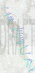
Paul, I have INEGI 50k and the old INEGI 50k hidden above, but I was looking at them when I made the above map and traced the drainages. My
highlights are a compromise between INEGI and Baja Almanac -- that's why they are sometimes wider than normal.
Here is the above map on INEGI and Old INEGI. Click to open (huge images)
|
|
|
PaulW
Ultra Nomad
Posts: 3113
Registered: 5-21-2013
Member Is Offline
|
|
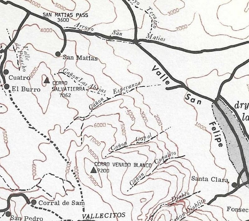
Abjeas?
I said:
I just traced all the drainages in that area and. . .
Nothing similar coming off labeled Esperanza on the INEGI topo.
However, there are two major drainages. The northly one is probably Esperanza as it is much larger, but the southern one has the label.
The two are connected the desert valley end.
My suspicion is the northern one is Esperanza and that leaves the southern one available for a canyon label ?? Abejas
Checkout my suspicions.
See my attached trace for Esperanza

|
|
|
geoffff
Senior Nomad
Posts: 721
Registered: 1-15-2009
Member Is Offline
|
|
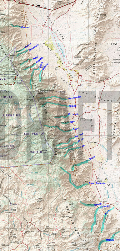
And here is my above map overlaid on Baja Almanac and Benchmark:

|
|
|
4x4abc
Ultra Nomad
Posts: 4456
Registered: 4-24-2009
Location: La Paz, BCS
Member Is Offline
Mood: happy - always
|
|
Las Abejas is on David's map
Harald Pietschmann
|
|
|
David K
Honored Nomad
Posts: 65581
Registered: 8-30-2002
Location: San Diego County
Member Is Offline
Mood: Have Baja Fever
|
|
Beautiful work, Geoff!
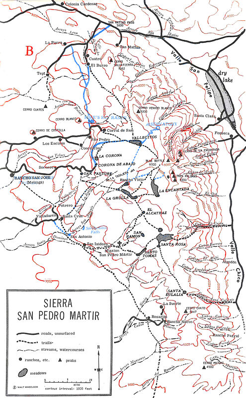
Abejas is the northernmost canyon in the 1967 Robinson map..
|
|
|
David K
Honored Nomad
Posts: 65581
Registered: 8-30-2002
Location: San Diego County
Member Is Offline
Mood: Have Baja Fever
|
|
Geoff, you have a newer edition printing of the book, and the arroyos/ canyons shown do not match with the topographic lines for them.
You can see the later printing has things shifted south a bit... I noticed this some years ago having compared various printings of Robinson's great
little book.
[Edited on 11-19-2021 by David K]
|
|
|
PaulW
Ultra Nomad
Posts: 3113
Registered: 5-21-2013
Member Is Offline
|
|
Like I said there is nothing similar to what Robinson shows.
Chalk it up and an error on his part.
Just look at the topo and prove it for yourself like I did.
[Edited on 11-19-2021 by PaulW]
|
|
|
geoffff
Senior Nomad
Posts: 721
Registered: 1-15-2009
Member Is Offline
|
|
| Quote: Originally posted by PaulW | | Like I said there is nothing similar to what Robinson shows. Chalk it up and an error on his part. Just look at the topo and prove it for yourself
like I did. [Edited on 11-19-2021 by PaulW] |
Yeah, I have to agree. And his Esperanza seems off as well.
| Quote: Originally posted by David K | | Geoff, you have a newer edition printing of the book, and the arroyos/ canyons shown do not match with the topographic lines for them.
|
Hah, you're right! Somehow I hadn't quite figured out why his map was hurting my brain so much.
|
|
|
geoffff
Senior Nomad
Posts: 721
Registered: 1-15-2009
Member Is Offline
|
|
Thank you!
Yeah, I have the 1979 edition it turns out.
|
|
|
geoffff
Senior Nomad
Posts: 721
Registered: 1-15-2009
Member Is Offline
|
|
And if you're curious about what changed on that map between 1967 and 1979 (excluding the misprinted red topo lines)... New 1979 stuff in blue:
|
|
|
4x4abc
Ultra Nomad
Posts: 4456
Registered: 4-24-2009
Location: La Paz, BCS
Member Is Offline
Mood: happy - always
|
|
Cañon Esperanza in this last map image is a major canyon
It has no name on INEGI it has no name on our last name lists
I am surprised that an expansive canyon like that should have no name

Harald Pietschmann
|
|
|
David K
Honored Nomad
Posts: 65581
Registered: 8-30-2002
Location: San Diego County
Member Is Offline
Mood: Have Baja Fever
|
|
| Quote: Originally posted by geoffff | And if you're curious about what changed on that map between 1967 and 1979 (excluding the misprinted red topo lines)... New 1979 stuff in blue:
|
Cool... since you did a nice comparison, let me add: Mike's Sky Ranch was placed too far east by Robinson (or Wheelock). It is actually closer to the
'San' in Arroyo San Rafael, north of Los Encinos (where Mike's original airstrip was).
|
|
|
4x4abc
Ultra Nomad
Posts: 4456
Registered: 4-24-2009
Location: La Paz, BCS
Member Is Offline
Mood: happy - always
|
|
mapping is a very difficult task
especially when you don't have many local records
the amount of names for Arroyos, Cerros, Lomas, Sierras, Puntas, Ensenadas and other features indicates how actively an area is used or has been used
OR NOT
the eastern slope of Sierra San Pedro Martir has only been used to travel through (mainly indians, some explorers since missionary times)
not many routes are suitable for traversing
no significant ranching or farming took place
thus there re only a few names for Arroyos/Cañadas and Cerros (even though there are some significant peaks and valleys present)
and since few people live in the area, locations and names are sketchy
adventurous expats might straighten things out - if they would only learn to spell established names right
Harald Pietschmann
|
|
|
mtgoat666
Platinum Nomad
Posts: 21147
Registered: 9-16-2006
Location: San Diego
Member Is Offline
Mood: Hot n spicy
|
|
| Quote: Originally posted by 4x4abc | mapping is a very difficult task
especially when you don't have many local records
the amount of names for Arroyos, Cerros, Lomas, Sierras, Puntas, Ensenadas and other features indicates how actively an area is used or has been used
OR NOT
the eastern slope of Sierra San Pedro Martir has only been used to travel through (mainly indians, some explorers since missionary times)
not many routes are suitable for traversing
no significant ranching or farming took place
thus there re only a few names for Arroyos/Cañadas and Cerros (even though there are some significant peaks and valleys present)
and since few people live in the area, locations and names are sketchy
adventurous expats might straighten things out - if they would only learn to spell established names right |
The world is full of unnamed drainages/canyons. Perfectly OK for canyons to be unnamed.
In the scheme of things, probably logical to name only the canyons that have usable surface water or trails (I.e. the visited/used canyons).
Why the obsession to record names for all the canyons?
Woke!
Hands off!
“Por el bien de todos, primero los pobres.”
“...ask not what your country can do for you – ask what you can do for your country.” “My fellow citizens of the world: ask not what America
will do for you, but what together we can do for the freedom of man.”
Pronoun: the royal we
|
|
|
4x4abc
Ultra Nomad
Posts: 4456
Registered: 4-24-2009
Location: La Paz, BCS
Member Is Offline
Mood: happy - always
|
|
that is a fundamental question
the basis of science is to collect as many data as possible - then you figure out what to do with it
the cartographer is covered in the "Little Prince"
chapterXV
https://www.sparknotes.com/lit/littleprince/section5/
Harald Pietschmann
|
|
|
4x4abc
Ultra Nomad
Posts: 4456
Registered: 4-24-2009
Location: La Paz, BCS
Member Is Offline
Mood: happy - always
|
|
why does your country, your city, the street you live on have a name?
why do you have a name?
Harald Pietschmann
|
|
|
PaulW
Ultra Nomad
Posts: 3113
Registered: 5-21-2013
Member Is Offline
|
|
List update with many corrections

|
|
|
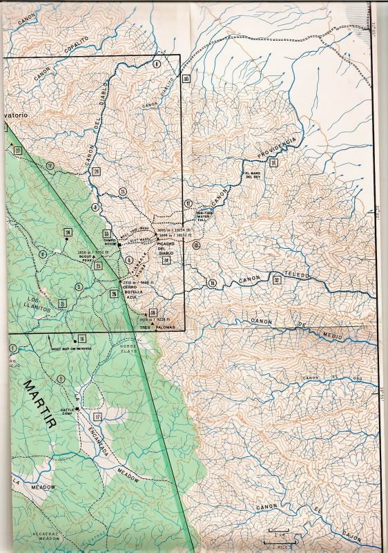
geoffff
Senior Nomad
Posts: 721
Registered: 1-15-2009
Member Is Offline
|
|
Excellent Paul!
Is this the "Schad-Diablo" map you are using above?
|
|
|
| Pages:
1
2
3
4
5
..
9 |