| Pages:
1
..
5
6
7
8
9 |
David K
Honored Nomad

Posts: 65581
Registered: 8-30-2002
Location: San Diego County
Member Is Offline
Mood: Have Baja Fever
|
|
Yes, it is on Bud's map, too. The next canyon north of Agua Caliente.
Could it be the Gringa or Rubi of newer maps??
[Edited on 12-9-2021 by David K]
|
|
|
geoffff
Senior Nomad
Posts: 721
Registered: 1-15-2009
Member Is Offline
|
|
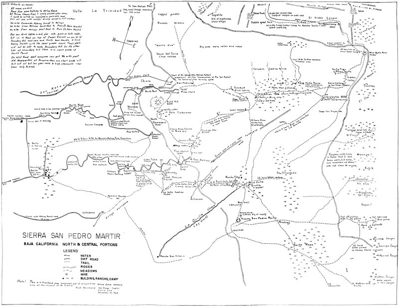
Here is the full image of the 1963 Bud Bernhard map of the Sierra San Pedro Martir area - combined from a series of photographs. Not crisp, but at
least it is readable. Click to enlarge to full size:
19631212--Bud-Bernhard-Map--Sierra-San-Pedro-Martir.jpg
|
|
|
Barry A.
Select Nomad
Posts: 10007
Registered: 11-30-2003
Location: Redding, Northern CA
Member Is Offline
Mood: optimistic
|
|
Canyons
Well done, Geofff!!! and David K... Many thanks. With "clicking" on the map image several times it looks to me like all the info is readable, tho
awkward to see the big-picture but doable.
Thanks again.
Barry
|
|
|
David K
Honored Nomad
Posts: 65581
Registered: 8-30-2002
Location: San Diego County
Member Is Offline
Mood: Have Baja Fever
|
|
Excellent... So many cool details, like where the Johnson water flume to Socorro mine begins, Soto cabin, etc.
Thank you very much Geoff... the double click to super enlarge is a great feature to read the notes.
|
|
|
BajaNomad
|
Threads Merged
12-12-2021 at 12:33 PM |
geoffff
Senior Nomad
Posts: 721
Registered: 1-15-2009
Member Is Offline
|
|
Yes! I was thinking Negro is what we now call El Cajon, since it is the most significant canyon around, and since Cajon starts just southwest of El
Cajón (El Chaparral).
-- Geoff
[Edited on 12-12-2021 by geoffff]
|
|
|
PaulW
Ultra Nomad
Posts: 3113
Registered: 5-21-2013
Member Is Offline
|
|
That canyon now 3 names El Cajon, Arenoso, and Negro
Quote: Originally posted by geoffff  |
Yes! I was thinking Negro is what we now call El Cajon, since it is the most significant canyon around, and since Cajon starts just southwest of El
Cajón (El Chaparral).
-- Geoff
[Edited on 12-12-2021 by geoffff] |
|
|
|
mtgoat666
Platinum Nomad
Posts: 21147
Registered: 9-16-2006
Location: San Diego
Member Is Offline
Mood: Hot n spicy
|
|
Bud’s map is a bit (a big bit) distorted, geographically.
I like the humorous and mysterious notes like “stones fly at night” at the mission graveyard and mystery steps at copal cyn. (Copalito)
Woke!
Hands off!
“Por el bien de todos, primero los pobres.”
“...ask not what your country can do for you – ask what you can do for your country.” “My fellow citizens of the world: ask not what America
will do for you, but what together we can do for the freedom of man.”
Pronoun: the royal we
|
|
|
David K
Honored Nomad
Posts: 65581
Registered: 8-30-2002
Location: San Diego County
Member Is Offline
Mood: Have Baja Fever
|
|
El Cajon is a major canyon system and well-known as also being the route used by the Indians and Dominicans to get to San Felipe Bay... I just don't
think there is any confusion on its name.
|
|
|
John Harper
Super Nomad
Posts: 2289
Registered: 3-9-2017
Location: SoCal
Member Is Offline
|
|
Fascinating map, thank you so much. I wonder how accurately the trails align with modern sat photos? Especially the trail mileage. I would assume
some of these trails are long disused.
John
[Edited on 12-13-2021 by John Harper]
|
|
|
PaulW
Ultra Nomad
Posts: 3113
Registered: 5-21-2013
Member Is Offline
|
|
Yes I agree, only one name is correct.
And there are other Indian trails across the mountain , like Aqua Caliente, but I cannot find a map of any actual Indian trails. Can anyone point me
to a link?
As you know El Cajon headwaters are at the mountain ridge a short distance for the headwaters of Arenoso which is the main branch of El Cajon. So, by
inspection of the topo either drainage could be used.
=== ===
| Quote: Originally posted by David K | | El Cajon is a major canyon system and well-known as also being the route used by the Indians and Dominicans to get to San Felipe Bay... I just don't
think there is any confusion on its name. |
|
|
|
geoffff
Senior Nomad
Posts: 721
Registered: 1-15-2009
Member Is Offline
|
|
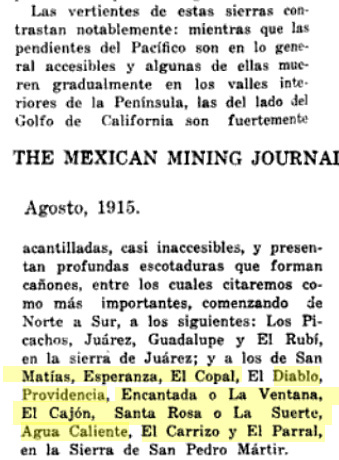
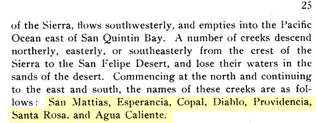
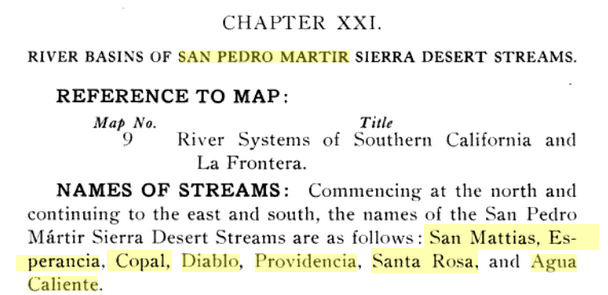
I did some searching on Google Books and turned up some old references to these canyons.
Multiple sources refer to a canyon "Santa Rosa" between Providencia and Agua Calienta -- which I presume is what we refer to as
Novillo (though it could be Barroso or Rubi) -- at least one of the canyons heading down from the site marked Santa Rosa on the map.
The Mining Journal refers to a canyon called "Encantada" or "Ventana" which could be either what we call Teledo or
En Medio. This also says another name for Santa Rosa is La Suerte.
The Mexican Mining Journal, Volumes 19-20, Aug 1915
https://books.google.com/books?id=CeE-AQAAMAAJ&pg=PA309&...
Lower California Natural Resources - Edward William Nelson, 1921
https://www.google.com/books/edition/Memoirs_of_the_National...

Report on the Northern District of Lower California by E Bartlett Webster, 1913
(I couldn't find a copy of MAP #9.)
https://www.google.com/books/edition/Report_on_the_Northern_...
American Geographical Society The Uncharted Sierra of San Pedro Martir, 1907
https://www.google.com/books/edition/Bulletin_of_the_America...
and then reprinted in Camp and Camino in Lower California A Record of the Adventures of the Author While Exploring Peninsular California,
Mexico by Arthur Walbridge North, 1910
https://www.google.com/books/edition/Camp_and_Camino_in_Lowe...

[Edited on 12-13-2021 by geoffff]
|
|
|
David K
Honored Nomad
Posts: 65581
Registered: 8-30-2002
Location: San Diego County
Member Is Offline
Mood: Have Baja Fever
|
|
I am very impressed, Geoffff.
fwiw, in the Rancho Meling history book, Cajon Canyon is mentioned as the one used to go down to the San Felipe Desert, early 1900s.
|
|
|
4x4abc
Ultra Nomad
Posts: 4456
Registered: 4-24-2009
Location: La Paz, BCS
Member Is Offline
Mood: happy - always
|
|
we have a new one!
Santa Rosa
but how do we locate it?
Harald Pietschmann
|
|
|
PaulW
Ultra Nomad
Posts: 3113
Registered: 5-21-2013
Member Is Offline
|
|
Anybody good at putting miles on the topo?
No can do here where I am without my resources.

|
|
|
David K
Honored Nomad
Posts: 65581
Registered: 8-30-2002
Location: San Diego County
Member Is Offline
Mood: Have Baja Fever
|
|
New authors copy old authors and so an error is just repeated...
THAT was a primary motivator for me to write the mission history facts and break the cycle of errors that kept being repeated.
Now, we have a new canyon, or do we?
Geoffff or ??, if we begin at San Matias Pass and go south 10 miles, are we near Esperanza?
If we go 6 more miles, are we at Diablo Canyon (at the base of Diablo Mountain [also called Providencia Mtn])?
Six miles past Diablo Canyon is Providencia Canyon, per this book.
8 miles past Providencia Canyon (30 miles from San Matias Pass) is 'Santa Rosa Canyon'... IS THIS ALSO 'EL CAJON CANYON'?
EDIT: I get 36 miles from San Matias to El Cajon Canyon, following the base of the sierra.
OK... distances are as the crow flies along the base of the sierra:
Mile 0: San Matias Pass
Mile 10: no name
(Mile 11.3: Esperanza)
Mile 16: Diablo
Mile 22: Providencia
Mile 30: (no name on maps) Santa Rosa?
Mile 33: En Medio
Mile 34: Novillo
Mile 36: El Cajon
Only the first named canyon (Esperanza) in the old books was off, by just 1-1/4 mile. The others matched up. Mile 30, that the book called Santa Rosa,
was not a very major looking canyon and has no name on the topo maps.
[Edited on 12-13-2021 by David K]
|
|
|
4x4abc
Ultra Nomad
Posts: 4456
Registered: 4-24-2009
Location: La Paz, BCS
Member Is Offline
Mood: happy - always
|
|
30 miles takes me to Cañada El Novillo
30°55'13.54"N, 115°15'15.97"W
Harald Pietschmann
|
|
|
4x4abc
Ultra Nomad
Posts: 4456
Registered: 4-24-2009
Location: La Paz, BCS
Member Is Offline
Mood: happy - always
|
|
According to the text Canyon Santa Rosa is a contributory to Cañada El Cajon
30°49'43.78"N, 115°18'51.41"W
Rancho Santa Rosa close by in the little valley described in the text above.
Harald Pietschmann
|
|
|
David K
Honored Nomad
Posts: 65581
Registered: 8-30-2002
Location: San Diego County
Member Is Offline
Mood: Have Baja Fever
|
|
Not close to the 30-mile distance... if it were El Cajon (36 miles).
Also, following the base of the sierra, going from canyon to canyon, I get 34 miles to Novillo. I do think that was how the author was measuring, from
one canyon named to the next.
However, I do think it may just be an error in the 30 mile distance from San Matias... because Santa Rosa being so important likely makes it part of
El Cajon, like you said???
|
|
|
mtgoat666
Platinum Nomad
Posts: 21147
Registered: 9-16-2006
Location: San Diego
Member Is Offline
Mood: Hot n spicy
|
|
| Quote: Originally posted by 4x4abc | According to the text Canyon Santa Rosa is a contributory to Cañada El Cajon
30°49'43.78"N, 115°18'51.41"W
Rancho Santa Rosa close by in the little valley described in the text above. |
Part of santa Rosa meadow drains eastward into a canyon that is tributary to El Cajon Canyon. There is an old indian/rancher trail that descends this
canyon, one of the few canyon trails you can see on google earth. Trail is not open any longer, is all grown over (well, 5 years ago it was grown
over the only time i hiked to santa rosa).
here is the trail 30°47'39.72"N, 115°18'43.08"W
here is santa rosa meadow 30°48'0.85"N, 115°20'43.51"W
Woke!
Hands off!
“Por el bien de todos, primero los pobres.”
“...ask not what your country can do for you – ask what you can do for your country.” “My fellow citizens of the world: ask not what America
will do for you, but what together we can do for the freedom of man.”
Pronoun: the royal we
|
|
|
PaulW
Ultra Nomad
Posts: 3113
Registered: 5-21-2013
Member Is Offline
|
|
I spent some time documenting the canyon locations. The coords I believe are very accurate.
I made note of the size of the canyons.
I also made note of the blue lines on the INEGI topos which I call "Grid". Make it easier when studying the hard copy of the maps. - especially when
my old fashioned method involves taping the screen shots together.
Anyway, here is my list of rank with regard to size of canyons. From the south
Comparing with Diablo a 10
Copal/Copalito a 5
Espiranza a 3
Burros a 4
Grid 53/54 a 7
Grid 57/58 a 5
My canyon traces are on page 5 of this thread
Here are the coordinates for the canyons
Attachment: Canyon LocationCOPY.xlsx (11kB)
This file has been downloaded 263 times
|
|
|
| Pages:
1
..
5
6
7
8
9 |


