| Pages:
1
2
3
4 |
JZ
Select Nomad

Posts: 14906
Registered: 10-3-2003
Member Is Offline
|
|
When in San Evaristo have a panga take you out to Isla San Jose and Isla San Francisco. You can find a guy by the little restaurant. About $100 to
go out for a half day or so.
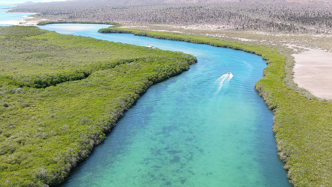
San Francisco

Mangrove on San Jose:
[Edited on 1-20-2022 by JZ]
|
|
|
4x4abc
Ultra Nomad
Posts: 4456
Registered: 4-24-2009
Location: La Paz, BCS
Member Is Offline
Mood: happy - always
|
|
Isla Pardito is a must visit
https://www.youtube.com/watch?v=alU5RQf0-8c
Harald Pietschmann
|
|
|
JZ
Select Nomad
Posts: 14906
Registered: 10-3-2003
Member Is Offline
|
|
I shot video of it once a couple years ago. And then 30 mins later crashed the drone into the side of the mountain on San Francisco.
I asked you once in a thread for the best hiking path to a specific gps location and you posted a kmz. That was to the drone.
|
|
|
100X
Nomad
Posts: 234
Registered: 11-3-2021
Member Is Offline
Mood: Thankful
|
|
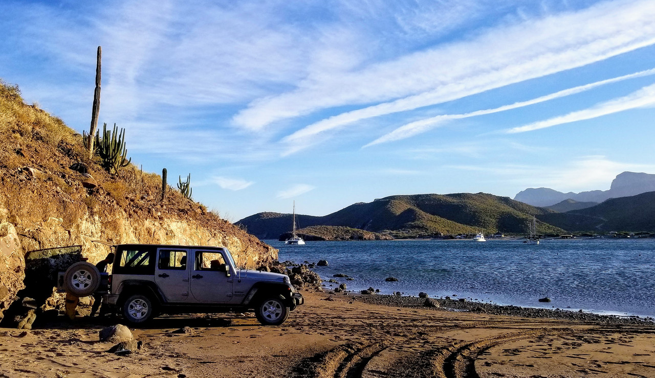
Going to be at San Evaristo and Los Burros next week. Is there a place to stay in San Evaristo or do I need to plan on camping? Best place to camp?
A life of fears leads to a death bed of regrets.
Find someone who will take care of you, and take care of them.
|
|
|
AKgringo
Elite Nomad
Posts: 6366
Registered: 9-20-2014
Location: Anchorage, AK (no mas!)
Member Is Offline
Mood: Retireded
|
|
Quote: Originally posted by 4x4abc  | actually I had an epic trip yesterday
trail in bad shape that hadn't been used in about 10 years
40 million year old ocean floor
very remote - no living soul in the area
|
Harald, I did a day trip from Campestre Maranatha. checking out beaches near Punta Coyote about eight years ago. I noticed tracks heading up the
arroyo just south of where the road is sandwiched between cliffs, and the sea, and decided to follow them.
The pair of tracks turned out to be one vehicle that did a U-turn about eight miles up the canyon, but it led me to some pretty impressive cliffs and
bedrock carved out of the pink, and green sedimentary deposits that are being mined in other places on that side of the peninsula.
I was driving my Kia Sportage 2dr with the top off, and wound up with leaves and twigs in the back seat, and dragged in a few spots, so it is not for
a standard SUV or large rig.
If you are not living on the edge, you are taking up too much space!
"Could do better if he tried!" Report card comments from most of my grade school teachers. Sadly, still true!
|
|
|
Mulege Canuck
Nomad
Posts: 393
Registered: 11-27-2016
Member Is Offline
|
|
| Quote: Originally posted by 4x4abc | | Quote: Originally posted by Mulege Canuck |
Love those photos Harold!
This is definitely a trip to make happen. I really appreciate the information. Now I just have to make sure my 2WD buddy does not back out.
|
then you go alone
don't let him keep you from doing the good stuff
some of the epic stuff I have done - I have done alone
after all the early enthusiasts had bailed out
there is only one person you can always trust - yourself
|
I have been down that road before….
Told my buddy to “Suck it up Princess “ . Once we got to our destination he did not talk to me for three Margaritas.
|
|
|
4x4abc
Ultra Nomad
Posts: 4456
Registered: 4-24-2009
Location: La Paz, BCS
Member Is Offline
Mood: happy - always
|
|
| Quote: Originally posted by 100X | | Going to be at San Evaristo and Los Burros next week. Is there a place to stay in San Evaristo or do I need to plan on camping? Best place to camp?
|
there are cabins for rent in San Evaristo
run by the people that have the restaurant and offer boat trips
https://www.facebook.com/barbarita.tours.mx/services
Harald Pietschmann
|
|
|
4x4abc
Ultra Nomad
Posts: 4456
Registered: 4-24-2009
Location: La Paz, BCS
Member Is Offline
Mood: happy - always
|
|
| Quote: Originally posted by AKgringo |
Harald, I did a day trip from Campestre Maranatha. checking out beaches near Punta Coyote about eight years ago. I noticed tracks heading up the
arroyo just south of where the road is sandwiched between cliffs, and the sea, and decided to follow them.
The pair of tracks turned out to be one vehicle that did a U-turn about eight miles up the canyon, but it led me to some pretty impressive cliffs and
bedrock carved out of the pink, and green sedimentary deposits that are being mined in other places on that side of the peninsula.
I was driving my Kia Sportage 2dr with the top off, and wound up with leaves and twigs in the back seat, and dragged in a few spots, so it is not for
a standard SUV or large rig. |
I was in the same area - just a bit south
my laptop was covered with leaves and Mezquite twigs
I rely on Google Earth for accurate locations
Gaia, Avenza and all the other crap only gives you a dot on a bad map
Google Earth rules
but I use a very old GPS to feed information to my laptop
I have done all the various GPS gimmicks since they first came out
they are only good with an RV on pavement
and there you don't need them anyway
remember David's zigg zagg lines from his inReach?
useless crap (for tracking and navigation - kinda good otherwise)
Harald Pietschmann
|
|
|
JZ
Select Nomad
Posts: 14906
Registered: 10-3-2003
Member Is Offline
|
|
| Quote: Originally posted by 4x4abc | | Quote: Originally posted by AKgringo |
Harald, I did a day trip from Campestre Maranatha. checking out beaches near Punta Coyote about eight years ago. I noticed tracks heading up the
arroyo just south of where the road is sandwiched between cliffs, and the sea, and decided to follow them.
The pair of tracks turned out to be one vehicle that did a U-turn about eight miles up the canyon, but it led me to some pretty impressive cliffs and
bedrock carved out of the pink, and green sedimentary deposits that are being mined in other places on that side of the peninsula.
I was driving my Kia Sportage 2dr with the top off, and wound up with leaves and twigs in the back seat, and dragged in a few spots, so it is not for
a standard SUV or large rig. |
I was in the same area - just a bit south
my laptop was covered with leaves and Mezquite twigs
I rely on Google Earth for accurate locations
Gaia, Avenza and all the other crap only gives you a dot on a bad map
Google Earth rules
but I use a very old GPS to feed information to my laptop
I have done all the various GPS gimmicks since they first came out
they are only good with an RV on pavement
and there you don't need them anyway
remember David's zigg zagg lines from his inReach?
useless crap (for tracking and navigation - kinda good otherwise) |
GE + Gaia or BCN is the way to go.
I do planning on GE with my big, clear monitor.
Can export to BCN on my phone in 30 seconds. Have satellite imagery for offline use on BCN.
|
|
|
AKgringo
Elite Nomad
Posts: 6366
Registered: 9-20-2014
Location: Anchorage, AK (no mas!)
Member Is Offline
Mood: Retireded
|
|
On that trip, I was using "line of sight", backed up by a AAA Baja map!
I was hoping that the arroyo/trail would connect to a road crossing over to the main highway, but mainly I was seeing what was around the next bend!
If you are not living on the edge, you are taking up too much space!
"Could do better if he tried!" Report card comments from most of my grade school teachers. Sadly, still true!
|
|
|
JZ
Select Nomad
Posts: 14906
Registered: 10-3-2003
Member Is Offline
|
|
| Quote: Originally posted by 100X | | Going to be at San Evaristo and Los Burros next week. Is there a place to stay in San Evaristo or do I need to plan on camping? Best place to camp?
|
If you do camp, the best place is the far North part of the bay. We built a big fire there this day.
[Edited on 1-21-2022 by JZ]
|
|
|
100X
Nomad
Posts: 234
Registered: 11-3-2021
Member Is Offline
Mood: Thankful
|
|
Thank you Harald and JZ.
JZ, the bay north of town and by what looks to be the second/largest arroyo (doesn't look like I can access the small bay to the east on the point)?
A life of fears leads to a death bed of regrets.
Find someone who will take care of you, and take care of them.
|
|
|
JZ
Select Nomad
Posts: 14906
Registered: 10-3-2003
Member Is Offline
|
|
| Quote: Originally posted by 100X |
JZ, the bay north of town and by what looks to be the second/largest arroyo (doesn't look like I can access the small bay to the east on the point)?
|
Here: 24°54'46.61"N 110°42'20.77"W
Yeah, I think you'd have to swim to the bay to the East.
To set your expectations properly. San Evaristo isn't a very pretty place. It's so, so. What is very beautiful is the drive into it and the islands
that are close offshore.
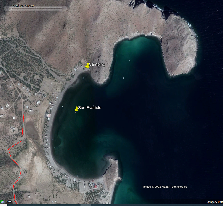
[Edited on 1-21-2022 by JZ]
|
|
|
4x4abc
Ultra Nomad
Posts: 4456
Registered: 4-24-2009
Location: La Paz, BCS
Member Is Offline
Mood: happy - always
|
|
San Evaristo has the only beach cemetery in Baja
there are several individual graves on the beach up and down Baja (one even in the water) - but not an entire cemetery on the beach
next to the Salina
check it out!

Harald Pietschmann
|
|
|
geoffff
Senior Nomad
Posts: 721
Registered: 1-15-2009
Member Is Offline
|
|
Gaia stopped using the Caltopo INEGI maps, and their replacement is mediocre.
but of course I am biased
|
|
|
4x4abc
Ultra Nomad
Posts: 4456
Registered: 4-24-2009
Location: La Paz, BCS
Member Is Offline
Mood: happy - always
|
|
tried a radical approach - no more beer
hard
very hard
but
no more pain
no more arthritis
no more depression
Harald Pietschmann
|
|
|
David K
Honored Nomad
Posts: 65584
Registered: 8-30-2002
Location: San Diego County
Member Is Online
Mood: Have Baja Fever
|
|
Amazing... a German not drinking beer???!!!
How wonderful that such a thing as not drinking beer would be so curative!!
I am very happy for you!  
|
|
|
Mulege Canuck
Nomad
Posts: 393
Registered: 11-27-2016
Member Is Offline
|
|
| Quote: Originally posted by JZ | | Quote: Originally posted by 100X |
JZ, the bay north of town and by what looks to be the second/largest arroyo (doesn't look like I can access the small bay to the east on the point)?
|
Here: 24°54'46.61"N 110°42'20.77"W
Yeah, I think you'd have to swim to the bay to the East.
To set your expectations properly. San Evaristo isn't a very pretty place. It's so, so. What is very beautiful is the drive into it and the islands
that are close offshore.
[Edited on 1-21-2022 by JZ] |
Thanks for that camping spot JZ
|
|
|
David K
Honored Nomad
Posts: 65584
Registered: 8-30-2002
Location: San Diego County
Member Is Online
Mood: Have Baja Fever
|
|
San Evaristo, August 2017
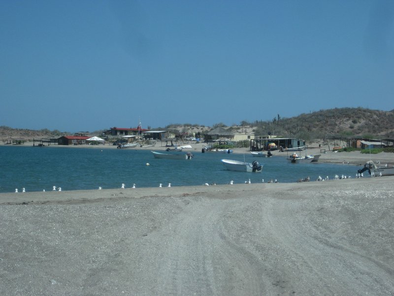
San Evaristo is a fishing village on an attractive bay.
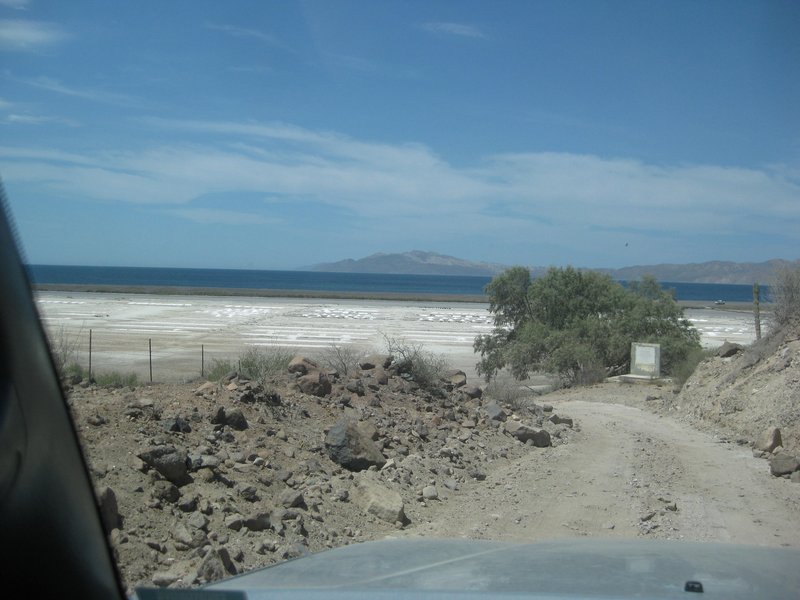
The salt works are just north of the village and where the road ends.
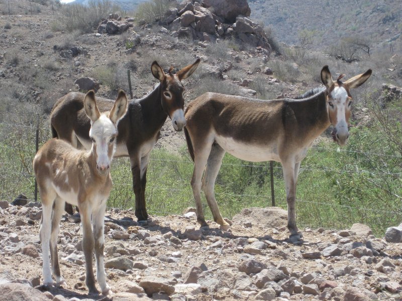
Locals along the road.
|
|
|
100X
Nomad
Posts: 234
Registered: 11-3-2021
Member Is Offline
Mood: Thankful
|
|
Thank you again JZ for clarifying the location.
I had wondered what those were in looking at GE--salt works--Thanks David. And I also have the cemetery now to check out!
I got on to the new GPS technology in 1997 I think, with a Garmin that you had to hand-type coordinates into. Luckily I was able to get them from the
Baja Almanac! I had ridden MC's to Cabo previously using mostly the more standard race routes, but wanted to see new stuff, so talked a group into
going and used the GPS to go through San Evaristo (as well as what the Baja Adventure Book called the "River Rock Trail" south of San Ignacio--only
night I ever had to sleep in the desert in a space blanket).
Thanks for all the info!
A life of fears leads to a death bed of regrets.
Find someone who will take care of you, and take care of them.
|
|
|
| Pages:
1
2
3
4 |


