| Pages:
1
..
6
7
8
9 |
PaulW
Ultra Nomad

Posts: 3113
Registered: 5-21-2013
Member Is Offline
|
|
The trail from Santa Rosa Meadow goes over the ridge to the east to one of the tributaries of El Cajon. If you have the topo the trail exists on the
Label "Canyon El Cajon" (No labels on Cal topo)
Good find Goat
=== ===
Quote: Originally posted by mtgoat666  | | Quote: Originally posted by 4x4abc | According to the text Canyon Santa Rosa is a contributory to Cañada El Cajon
30°49'43.78"N, 115°18'51.41"W
Rancho Santa Rosa close by in the little valley described in the text above. |
Part of santa Rosa meadow drains eastward into a canyon that is tributary to El Cajon Canyon. There is an old indian/rancher trail that descends this
canyon, one of the few canyon trails you can see on google earth. Trail is not open any longer, is all grown over (well, 5 years ago it was grown
over the only time i hiked to santa rosa).
here is the trail 30°47'39.72"N, 115°18'43.08"W
here is santa rosa meadow 30°48'0.85"N, 115°20'43.51"W
|
|
|
|
4x4abc
Ultra Nomad
Posts: 4456
Registered: 4-24-2009
Location: La Paz, BCS
Member Is Offline
Mood: happy - always
|
|
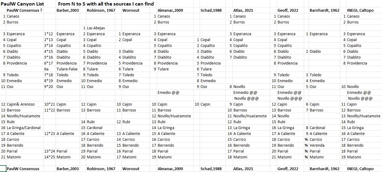
| Quote: Originally posted by PaulW | I spent some time documenting the canyon locations. The coords I believe are very accurate.
I made note of the size of the canyons.
I also made note of the blue lines on the INEGI topos which I call "Grid". Make it easier when studying the hard copy of the maps. - especially when
my old fashioned method involves taping the screen shots together.
Anyway, here is my list of rank with regard to size of canyons. From the south
Comparing with Diablo a 10
Copal/Copalito a 5
Espiranza a 3
Burros a 4
Grid 53/54 a 7
Grid 57/58 a 5
My canyon traces are on page 5 of this thread
Here are the coordinates for the canyons
|
Google Earth does not read that format
Harald Pietschmann
|
|
|
4x4abc
Ultra Nomad
Posts: 4456
Registered: 4-24-2009
Location: La Paz, BCS
Member Is Offline
Mood: happy - always
|
|
well, geoffff posted the answer little ways up
you just need to read what our members are posting

Harald Pietschmann
|
|
|
PaulW
Ultra Nomad
Posts: 3113
Registered: 5-21-2013
Member Is Offline
|
|
I mentioned my Grid locations only applied to paper Topos or downloaded topos from INEGI
Anyway, here is the JPG for the accurate locations of various canyon mouths. This will allow use of Google earth to see the canyons.

| Quote: Originally posted by PaulW | I spent some time documenting the canyon locations. The coords I believe are very accurate.
I made note of the size of the canyons.
I also made note of the blue lines on the INEGI topos which I call "Grid". Make it easier when studying the hard copy of the maps. - especially when
my old fashioned method involves taping the screen shots together.
Anyway, here is my list of rank with regard to size of canyons. From the south
Comparing with Diablo a 10
Copal/Copalito a 5
Espiranza a 3
Burros a 4
Grid 53/54 a 7
Grid 57/58 a 5
My canyon traces are on page 5 of this thread
Here are the coordinates for the canyons
|
|
|
|
PaulW
Ultra Nomad
Posts: 3113
Registered: 5-21-2013
Member Is Offline
|
|
Harald,
I agree a very large canyon, and is several times bigger than the INEGI
version of Esperanza. Also it meets the criteria of a fork leading NW like the old maps show for Esperanza. That fork may be Abejas?
The mouth of that canyon is 3311 12.215, -115 26.987

| Quote: Originally posted by 4x4abc | Cañon Esperanza in this last map image is a major canyon
It has no name on INEGI it has no name on our last name lists
I am surprised that an expansive canyon like that should have no name
|
|
|
|
David K
Honored Nomad
Posts: 65581
Registered: 8-30-2002
Location: San Diego County
Member Is Offline
Mood: Have Baja Fever
|
|
Bud in a 1960 photo
With thanks to Vince...
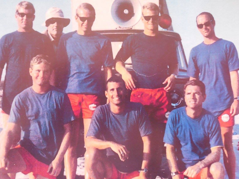
Photo from 1960. Bud Bernhard with hat in back, front row: Alan Hansen, Mike Neil, Mike Flynn. Back Row: Ed Paterson on right, not sure of the
others except for Bud.
Bud's maps:
https://octopup.org/img/media/maps/baja/valle-chico/1962--Bu...
https://octopup.org/img/media/maps/baja/valle-chico/19631212...
[Edited on 1-17-2022 by David K]
|
|
|
geoffff
Senior Nomad
Posts: 721
Registered: 1-15-2009
Member Is Offline
|
|
Here is a circa 1935 photo from Margaret Wood Bancroft's trip, showing the Sierra San Pedro Martir canyons in order:
Matomi, Parral, Berendo, Carriso, Agua Caliente, El Cajon, Providencia
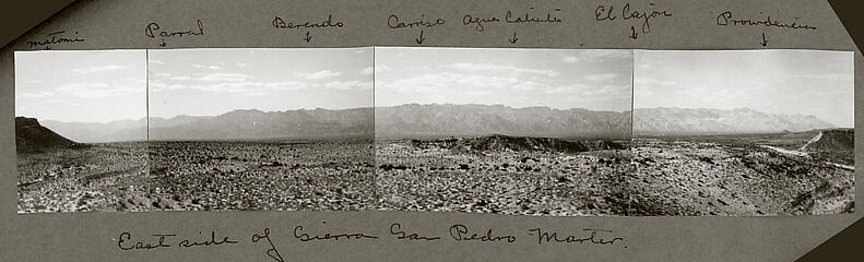
(click to enlarge)
|
|
|
David K
Honored Nomad
Posts: 65581
Registered: 8-30-2002
Location: San Diego County
Member Is Offline
Mood: Have Baja Fever
|
|
Very cool, geoffff!
Can one figure out where the photo was taken from, using Google Earth or ??
|
|
|
geoffff
Senior Nomad
Posts: 721
Registered: 1-15-2009
Member Is Offline
|
|
Tricky to pin down for sure. With the small foreground hill in the center, and the slope on the left, maybe here? 30.7658, -115.0451
|
|
|
4x4abc
Ultra Nomad
Posts: 4456
Registered: 4-24-2009
Location: La Paz, BCS
Member Is Offline
Mood: happy - always
|
|
Providencia!
Harald Pietschmann
|
|
|
4x4abc
Ultra Nomad
Posts: 4456
Registered: 4-24-2009
Location: La Paz, BCS
Member Is Offline
Mood: happy - always
|
|
Cañada de Enmedio!
Harald Pietschmann
|
|
|
4x4abc
Ultra Nomad
Posts: 4456
Registered: 4-24-2009
Location: La Paz, BCS
Member Is Offline
Mood: happy - always
|
|
Cañada El Novillo
Harald Pietschmann
|
|
|
PaulW
Ultra Nomad
Posts: 3113
Registered: 5-21-2013
Member Is Offline
|
|
One more correction

[Edited on 12-4-2022 by BajaNomad]
|
|
|
bajatrailrider
Ultra Nomad
Posts: 2555
Registered: 1-24-2015
Location: Mexico
Member Is Offline
Mood: Happy
|
|
The Trail La Grulla
From El Coyote was done first time ever on Motos by El Coyote brothers . Total of 5 guys last year they had other Cowboys. Bring tents and food by
horse back to La Grulla. They made it out to A gal I know rancho just east north of San Quintin. We have rode up there rancho road from bottom of
rancho. Its a great 4X4 road but real bad at the time another abandon rancho at top. We hope to return there again soon.
|
|
|
David K
Honored Nomad
Posts: 65581
Registered: 8-30-2002
Location: San Diego County
Member Is Offline
Mood: Have Baja Fever
|
|
La Grulla Meadow was discovered to be Casilepe of mission times, where Mission San Pedro Mártir was first established. Within about three months, the
Dominicans had enough of the freezing cold (it was founded on April 27, 1794) and moved the mission about 2,000 feet lower in elevation where it
remained until a particulary cold winter in 1811!
|
|
|
David K
Honored Nomad
Posts: 65581
Registered: 8-30-2002
Location: San Diego County
Member Is Offline
Mood: Have Baja Fever
|
|
Big thanks to PaulW for working on the canyon list!
There was a nice photo post on Providencia Canyon, on Facebook today.
|
|
|
PaulW
Ultra Nomad
Posts: 3113
Registered: 5-21-2013
Member Is Offline
|
|
Lou Wells archive - Canyons
Canyons from archives from Lou Well. Coordinates from Google Earth
Lou’s written reports have been lost due to the web site being abandoned.
Esperanza 31° 8.437'N, -115 25.223
water almost always within a few hundred yards up the canyon
 pic 2 pic 2
 Pic 3 Pic 3
Diablo 312 4.491, -115 22.391
Entry into Diablo Canyon, which has waterfalls, and is access to climbing the mountain.
Parking 31 4.451, -115 21.925
Parking for the entry to Diablo Canyon, Cross a rock hill to the northwest and drop into the riverbed for your trip to the water and waterfall. 31
8.437, -115 25.223
 Pic 4 Pic 4
 Pic 5 Pic 5
Provindincia 31 1.998, -1156 17.766
The entry to Providintia canyon, also a route for climbing Picacho del Diablo. It is said to have 7 waterfalls falling into 7 separate pools. Water is
piped out to rancho's in the valley.
 Pic 6 Pic 6
 Pic 7 Pic 7
 Pic 8 Pic 8
En Medio 30 55.16, -115 15.073
No Pictures
== == =
|
|
|
PaulW
Ultra Nomad
Posts: 3113
Registered: 5-21-2013
Member Is Offline
|
|
Lou Well Archive cont.
Cajon 30 51.274, -115 14.110
Canyon Cajon - small waterfalls a short distance up the canyon. Large water tank near entry for storing water for cattle. Small private rancho at
mouth. At one time in the past, a trail led up over the Sierra San Pedro Matir to Santa Rosa Meadow on the west side of the summit. Trail was washed
away by storms several years ago.
Canyon Cajon - small waterfalls a short distance up the canyon. Large water tank near entry for storing water for cattle. Small private rancho at
mouth.
At one time in the past, a trail led up over the Sierra San Pedro Matir to Santa Rosa Meadow on the west side of the summit. Trail was washed away by
storms several years ago
Barrasa 30 49.744, -115 13.237
No pictures
Agua Caliente Canon 30° 39.427'N, -115° 9.820'W
Entry point for Agua Caliente Canon. Hot springs being developed several miles into canyon. Picture is water tank in mouth of the canyon.
 Pic 9 Pic 9
 Pic 10 Pic 10
 Pic 11 Pic 11
 Pic 12 Pic 12
Parking area for visiting the hot springs. 30° 38.929'N, -115° 12.166'W
Agua Caliente hot springs 30° 38.841'N, -115° 12.457'W
Several hot pools bubbling from the ground in this area - Temperature is about 142 deg. so be careful
 Pic 13 Pic 13
 Pic 14 Pic 14
As of spring of 2022 to get to the spring required 4x4 with winch and the spring was not noticeable.
As of fall 2022 after the hurricane a report that the road in now impassable passed the gate.
Berendo Canyon 30° 33.753'N, -115° 7.853'W
Berendo canyon with it's hillsides covered with Blue Palms is a jewel. A short walk up the canyon thru the palms brings you to wonderful views of
pools and the flowing water.
30° 32.467'N, -115° 7.956'W
 Pic 15 Pic 15
 Pic 16 Pic 16
Continued next
=== ===
|
|
|
PaulW
Ultra Nomad
Posts: 3113
Registered: 5-21-2013
Member Is Offline
|
|
Lou Well Archive Cont.
Berrendo Cont.
 Pic 17 Pic 17
Parral Canyon wash 30° 33.159'N, -115° 5.278'W
Locked Gate? 30° 32.831'N, -115° 5.509'W
Rancho Parral 30° 29.399'N, -115° 6.991'W
Great oasis in a wonderful canyon. A locked gate now keeps visitors from the ranch area of the canyon.
 Pic 18 Pic 18
 Pic 19 Pic 19
 Pic 20 Pic 20
 Pic 21 Pic 21
Matomi entry from Valle Chico 30° 29.655'N, - 115° 1.542'W
Rancho Matomi 30° 27.412'N, - 115° 4.872'W
Rancho Matome - with the Blue Palms along the waterway below - a beautiful spot.
 Pic 22 Pic 22
 Pic 23 Pic 23
|
|
|
David K
Honored Nomad
Posts: 65581
Registered: 8-30-2002
Location: San Diego County
Member Is Offline
Mood: Have Baja Fever
|
|
Bravo!
Sure miss Lou...
Thanks for posting these.
|
|
|
| Pages:
1
..
6
7
8
9 |


