| Pages:
1
2 |
PNWers
Newbie
Posts: 10
Registered: 2-9-2023
Member Is Offline
|
|
Draft Baja California itinerary - thoughts?
My wife and I are setting out later this month for our first foray into Baja California. Because we haven’t done this before, we’ve been reading
the various forums, including this one, and have put together a very rough outline of an 10-12 day itinerary, always understanding that we may divert
to go exploring wherever looks interesting in the moment. We also have spent a lot of time poring over David K's fantastic Baja Guide (the latest
available online), as well as a lot of the notes from his 2017 research trip.
We’ve really enjoyed reading the forums on this site, and hope that some folks may be wiling to give us input on whether this plan makes sense. We
promise a full trip report to follow.
We are traveling in our regular camping rig, which is a Toyota Tacoma with a hardshell rooftop tent mounted on a rack that sits about six inches above
the bed (the bed itself has a soft rollup tonneau cover). We carry everything we need, including a 16-gallon water tank. Our plan is to mostly
boondock. We frequently do that in the US, traveling as far up remote USFS or BLM roads as we can get, to camp in isolated spots without any other
people around, and then hiking from there (we typically spend 40+ nights a year camping with this set up). In Mexico, we understand that it sometimes
will make more sense to stay at low-key palapa-type campsites or to ask ranchers for permission to camp on their land.
Our general plan is to enter at Tijuana, get groceries around Ensenada, and spend our first night on the beach near Puerto Santo Tomás or, if that
doesn’t work out, in the campground in Santo Tomás itself.
We’ll then spend at least two nights in Parque Nacional Sierra de San Pedro Martír, hiking the trails that head off from the campsites. We know it
may still be very cold, even snowy, and we’re prepared for that.
After that, we have an inland plan for a loop off of Hwy 1. We’d start by heading from SPM back out to Hwy 1, then cut inland again south of
Vincente Guerrero to go up to the ruins at San Isidoro (we know we may have to hike quite a way in). Road conditions permitting, we’d then head
south, taking a look at the petroglyph sites. We’d either end up going back west to the Pacific Coast at Hwy 1 around Santa Maria or - again, roads
permitting - go south to emerge on the east-west portion of Hwy 1 around El Sacrificio. We’d plan to spend at least one night camping inland
somewhere along that loop. More than that if we end up somewhere that we feel comfortable leaving our truck and hiking for a day. Question:
given our limited time, is doing this loop worth it on our first trip to Baja? We understand that doing this might preclude going down to Bahia de
Los Angeles, but we’re not really “hanging out on the beach for days” folks….
Another question: If we do the loop described above and pop out at El Sacrificio, will we need to head back to El Rosario anyway to get gas
before driving east on Hwy 1? If so, it probably would make more sense to take what looks like the easier route out of the loop and end up
at Hwy 1 north of El Rosario.
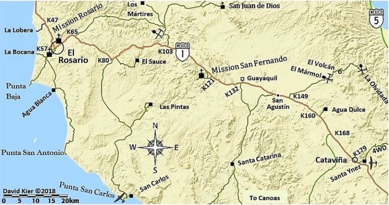
From there, we’d keep going on Hwy 1, stopping next either at the area around El Sauce / Las Pintas (rock paintings) or Cataviña (if the former,
we’d camp; if the latter, we’d probably stay at the hotel). Again, if we’re intrigued by the area(s), we could easily stay for more than one
night.
Next, if we have time, we’d keep going southeast, stopping either at Bahia de Los Angeles or further south, somewhere between there and San
Francisquito, hoping to beach camp in one place or the other (either boondocking or at palapa sites). That’s enough of a drive that we’d probably
want to spend at least two nights wherever we land. We’re trying to decide whether to spend more time inland or whether we should, instead,
try to make it all the way to BOLA or even further south.
After that (from either Cataviña or BOLA, depending on our timing), we’d head north on Hwy 5, beach camping one night south of San Felipe. Then it
looks like it would be interesting to head into the desert west/southwest of San Felipe, boondocking for a night or two. We know we may not
have time to do that, depending what we’ve done the rest of our trip.
Then driving to Tecate to exit.
We can spend 12 nights tops in Baja on this first trip, maybe a couple of days less than that.
Any thoughts? If you were going to cut one or two stops out of this itinerary, which would you omit?
We really appreciate this forum. We’ll give a detailed report about the trip when we return.
|
|
|
David K
Honored Nomad

Posts: 65563
Registered: 8-30-2002
Location: San Diego County
Member Is Offline
Mood: Have Baja Fever
|
|
Happy that you found helpful intel on my VivaBaja site.
The photos are nice hints at what you may see and that alone makes a place interesting enough to check out.
Obviously, you will see a lot more than my photos can show. Being there in person is so much better!
Top your tank at Vicente Guerrero, and if you bring a 5-gal gas jug, fill it there, too. Do not bring gas cans into Mexico with gas in them!
The road up to San Isidoro was traveled by TMW and The squarecircle, in 2016 (maybe read their trip report http://forums.bajanomad.com/viewthread.php?tid=81801 ).
You can drive right to the creek, across from the ruins, on a knoll (you won't see them until you walk across the creek). A photo by TMW of the chapel
ruins was the last one added to my book before it went to the printers. It is on page 216.
Are you going to go to Petroglyph Park, which is a few miles out of your way, before continuing south to El Sacrificio/ Los Mártires road?
Not a lot there, but is was a cool discovery my wife-to-be and I made back in 2005: https://vivabaja.com/p1105/
Baja Nomad member 'geoffff' traveled there, and to San Isidoro, in 2016: https://octopup.org/baja2016/san-isidoro He makes such excellent trip reports here and on his website!
With a Tacoma, you can make close to 300 miles if you don't use 4WD a lot. You shouldn't need to go back to El Rosario from El Sacrificio. They do
sell gas at Cataviña and the L.A. Bay junction, out of cans for an extra charge per gallon.
All in all an excellent adventure, however the heavy rains of this winter and last September's hurricane (Kay), may have messed up the backcountry
roads. Don't feel you HAVE TO go to all these places as Baja has so many more that are easier to get to... and relax on a beach or a white sand
arroyo, where you can hike to beautiful palm oases.
Hope to see a trip report when you return!
EDIT: I bumped up the trip report from TMW (with John M & The squarecircle) going to San Isidoro (Three Amigos)
[Edited on 2-12-2023 by David K]
|
|
|
bajaric
Senior Nomad
Posts: 681
Registered: 2-2-2015
Member Is Offline
|
|
interesting itinerary!
Free camping in the general area around Puerto Santo Thomas is not very safe and the area is pretty built up. The first night I would stay in a paid
campground.
SPM you will likely have all to yourself.
The roads east of Vincente Guerrero / Nueva York on the long loop you are contemplating might be pretty tough. There is not much of anything back in
there and the roads may not have been graded since Kay wrought havoc on dirt roads across northern Baja. I would think it would be pretty safe,
though you never know what sort of people might be wandering about. The farther away you can get from the outskirts of San Quintin the better. Trust
your gut if is feels right to camp overnight. By the end of that you will be pretty sick of dirt roads, I would just blast through Catavinia to BOLA
where there is gas, motels, and a chance to regroup, then head south.
I would skip camping west of San Felipe. People have disappeared out there.
[Edited on 2-11-2023 by bajaric]
|
|
|
PNWers
Newbie
Posts: 10
Registered: 2-9-2023
Member Is Offline
|
|
All of this is very helpful, thanks. Any ideas for secure, paid camping in Puerto Santo Tomás area, or just south of there? We'd definitely prefer
to be somewhere scenic, not right on Hwy 1.
|
|
|
David K
Honored Nomad
Posts: 65563
Registered: 8-30-2002
Location: San Diego County
Member Is Offline
Mood: Have Baja Fever
|
|
La Bocana and Puerto Santo Tomas (has a website) has rooms and camping... I did not go past La Bocana, which looked deserted in October 2017... Pretty
estuary, however.
From my web page https://vivabaja.com/p1017/ about this area:
The sun was dropping and I had to see one other spot before arriving at my destination for the next two nights, La Bocana at the end of Arroyo
Santo Tomás. The road is at Km. 47 and once beyond the ejido at the junction (El Ajusco) the graded dirt road was very smooth. There was a lot of
traffic that afternoon and lots of blind curves, so no high speed. It is 28 kms. or about 17 miles from Hwy. 1 to the beach at La Bocana. The location
was almost ghostly with empty homes, yet there is so much potential here.
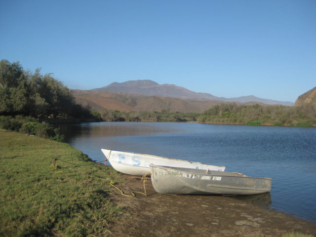
The beach on the south side of the estuary, as seen from La Bocana homes:
The Puerto Santo Tomas website page for camping: http://www.puertosantotomas.com/rentals.html
Baja Nomad 'DanO' seems to know this place best... He hasn't posted in almost a year, however.
[Edited on 2-12-2023 by David K]
|
|
|
PNWers
Newbie
Posts: 10
Registered: 2-9-2023
Member Is Offline
|
|
Again, this is all so helpful. The reason we're thinking about areas in the inland mountains is because we love desert hiking/camping. To give you
an idea, we've spent weeks hiking and dry camping in the more remote areas of Death Valley, the Mojave desert, and KOFA. So the area around Cataviña
looks great. I stumbled across a website for Parque El Palmerito outside of Cataviña, run by Ian Velazco. Any thoughts on camping there? (Not
using the cabaña.) I'll also post a question on just that topic, to catch anybody who may not be looking at this thread.
|
|
|
mtgoat666
Platinum Nomad
Posts: 21094
Registered: 9-16-2006
Location: San Diego
Member Is Offline
Mood: Hot n spicy
|
|
Quote: Originally posted by PNWers  | | Again, this is all so helpful. The reason we're thinking about areas in the inland mountains is because we love desert hiking/camping. To give you
an idea, we've spent weeks hiking and dry camping in the more remote areas of Death Valley, the Mojave desert, and KOFA. So the area around Cataviña
looks great. I stumbled across a website for Parque El Palmerito outside of Cataviña, run by Ian Velazco. Any thoughts on camping there? (Not
using the cabaña.) I'll also post a question on just that topic, to catch anybody who may not be looking at this thread. |
My 2 favorite places in baja are SPM and Catavina. Catavina hotel is great. Boulder field north side of Catavina are good for bouldering, some
dispersed camping, hiking, etc.. Never seen Palmerito, so got nothing on that
Woke!
Hands off!
“Por el bien de todos, primero los pobres.”
“...ask not what your country can do for you – ask what you can do for your country.” “My fellow citizens of the world: ask not what America
will do for you, but what together we can do for the freedom of man.”
Pronoun: the royal we
|
|
|
David K
Honored Nomad
Posts: 65563
Registered: 8-30-2002
Location: San Diego County
Member Is Offline
Mood: Have Baja Fever
|
|
| Quote: Originally posted by PNWers | | Again, this is all so helpful. The reason we're thinking about areas in the inland mountains is because we love desert hiking/camping. To give you
an idea, we've spent weeks hiking and dry camping in the more remote areas of Death Valley, the Mojave desert, and KOFA. So the area around Cataviña
looks great. I stumbled across a website for Parque El Palmerito outside of Cataviña, run by Ian Velazco. Any thoughts on camping there? (Not
using the cabaña.) I'll also post a question on just that topic, to catch anybody who may not be looking at this thread. |
Have you considered hiking on the El Camino Real mission trail?
For the past 22 years, a couple have been researching and documenting the true routes used by the padres in the 1700s, from Loreto north to El
Rosario. Their website (and link to their Google Earth waypoints map) is at www.caminorealbaja.com
You can hear their story on a recent Slow Baja podcast: https://www.slowbaja.com/episodes/backpacking-the-el-camino-...
Their research now is shared with anyone who owns the Benchmark Baja Atlas... with the 'ECR' trail plotted on it.
Here is a page I made providing location where the old Camino Real crosses or contacts modern roads, plus links to maps and photo of ECR: https://vivabaja.com/ecr-crossings/
Baja Nomad 'geoffff' has connected their waypoints on a couple of different base maps, here is one (extra click to zoom in close): https://octopup.org/img/misc/davidk/ecr/caminorealbaja-com-t...
|
|
|
PNWers
Newbie
Posts: 10
Registered: 2-9-2023
Member Is Offline
|
|
The ECR looks fantastic - maybe for our *next* Baja trip. :-)
|
|
|
wilderone
Ultra Nomad
Posts: 3912
Registered: 2-9-2004
Member Is Offline
|
|
You might consider a night at Cielito Lindo motel/RV park/campground/restaurant. I mention this because it is an old school Baja locale - on the
beach (beachcombing), and you can get a beer or meal there too. The small tent "campground" - room for about 3 vehicles/tents - has a table - was
$10/nt when I was there last. If the wind is blowing, being inside the restaurant is nice - TVs too. And showers.
The La Chorerra area west of San Quintin (from the military base road) is an area I have not personally explored, but is becoming noted for its fresh
seafood. Camping too, and as I understand, kayak rentals for the estuary at high tide.
|
|
|
ReTire
Nomad
Posts: 129
Registered: 9-16-2018
Location: PNW
Member Is Offline
|
|
For my 1st crossing I decided not to do Tijuana. Never been through there, but it seems huge and very busy with lots of lanes. Tecate isn’t that far
from there and the crossing was easy peasy (after I bought some of the officials home made jerky!)
Like I read from David K, don’t bring full gas cans across. I got some advice not to bring groceries either. I guess it’s frowned upon. Easy to
stock up across the border.
|
|
|
David K
Honored Nomad
Posts: 65563
Registered: 8-30-2002
Location: San Diego County
Member Is Offline
Mood: Have Baja Fever
|
|
Tijuana is actually the easiest, no cross-city traffic as you can get right on the border fence road out to the toll highway, called the Scenic Road,
Mex #1-D, signed for Playas & Rosarito, (when you leave the border crossing area).
You will need the FMM tourist permit (if you want to be legal) and Tijuana is the easiest place to get it, as it has a big, covered parking area in
front of the building you go into. See pictures in my March 2022 Trip Report. Mexicali West is the second best place... 5+ miles of city driving
after, however.
Tecate is my preferred return crossing border. Southbound, getting the tourist permits is not as easy... one -way streets, to get to the restricted
parking, lots of walking, turnstiles, crossing the entrance street just to get the FMMs. Some park on the U.S. side, walk into Mexico for the FMMs,
then go through U.S. customs to get back to their car!
|
|
|
bajaric
Senior Nomad
Posts: 681
Registered: 2-2-2015
Member Is Offline
|
|
| Quote: Originally posted by PNWers | | All of this is very helpful, thanks. Any ideas for secure, paid camping in Puerto Santo Tomás area, or just south of there? We'd definitely prefer
to be somewhere scenic, not right on Hwy 1. |
There was a thread about camping near Santo Tomas
http://forums.bajanomad.com/viewthread.php?tid=98295#pid1245...
Not too
Perhaps a good alternative would be "Campo #5" out towards the end of the Punta Banda peninsula. From there it is a short dive to check out La
Bufadora "the world's second largest waterspout'. You have to run a gauntlet of tourist trap shops to see it but pretty impressive if you never have,
and free other than a couple of dollars for parking. Also there is a trail along the western edge of Punta Banda; you could leave your vehicle in the
secure campo 5 and hike the trail along the edge and up to the top of the peak there. Unspoiled coastal sage scrub habitat with some outstanding
views.
Not to be a downer, and I have remote camped in Baja many times but I like to leave the vehicle in a secure area if I am going to go off on a long
hike. Either a secure campo e.g. Campo Ynez or at a friedly rancho. A vehicle left off by itself in the middle of nowhere with a battery and a
decent set of tires and rims is an inviting target for some.
|
|
|
David K
Honored Nomad
Posts: 65563
Registered: 8-30-2002
Location: San Diego County
Member Is Offline
Mood: Have Baja Fever
|
|
In that thread on 11-28-22:
| Quote: Originally posted by John M | Greetings Mick,
Just north of Santo Tomas take the nicely graded road through the valley heading west all the way to the Pacific at La Bocana - we've camped on the
beach there sometime ago. If instead going to the left to the sandy area you go north along the ocean, past the houses, there is some open areas on an
elevated mesa before you get to the end of the road.
Neither would be "campgrounds."
Coyote Cal's a couple miles north of Erendira along the ocean is a campground. We've not stayed there.
John M" |
|
|
|
PNWers
Newbie
Posts: 10
Registered: 2-9-2023
Member Is Offline
|
|
Thanks, all, for the good advice. We'll give a detailed report upon return.
|
|
|
PNWers
Newbie
Posts: 10
Registered: 2-9-2023
Member Is Offline
|
|
Sorry - One more question. Any thoughts on a place called Arco de Campanita (at Puerto Santo Tomás) associated with a Danny Canseco? TIA.
|
|
|
PNWers
Newbie
Posts: 10
Registered: 2-9-2023
Member Is Offline
|
|
Also, after reading many comments about the state of affairs Bahía de Los Angeles here, we’ve decided instead to explore the Pacific coast per Log
11 in David K’s book and the thread here titled something like “looking for a new Pacific beach.” Planning to stay at the Baja Cactus in El
Rosario before we head out. As always, we’re grateful for any thoughts folks may have, and we’ll give a report when we return.
|
|
|
wilderone
Ultra Nomad
Posts: 3912
Registered: 2-9-2004
Member Is Offline
|
|
Punta Baja just west of El Rosario is kinda cool. There is a fishing fleet that goes out in the mornings, returns in the afternoon with their catch
for the cannery in town. There is also a woman in the small community who makes empanadas which are sold in town. Nice little area at the point for
camping - could get windy if the wind is blowing. Nice drive out there. And a road from there that goes SE along the coast. I was walking it so I
don't remember exactly the driving conditions for that section, but most of it as I recall was hard packed dirt. To get to the road out there, turn
Right at the main road/ Hwy 1 intersection at the Baja Cactus/gas station,'til you come to the cannery, then turn left into the arroyo, cross the
arroyo, turn Right, to the sign on the left uphill to begin road to Punta Baja. After crossing the arroyo and turning right, there is a small museum
along the way that is interesting, but sporadic hours of operation.
|
|
|
David K
Honored Nomad
Posts: 65563
Registered: 8-30-2002
Location: San Diego County
Member Is Offline
Mood: Have Baja Fever
|
|
| Quote: Originally posted by PNWers | Also, after reading many comments about the state of affairs Bahía de Los Angeles here, we’ve decided instead to explore the Pacific coast per Log
11 in David K’s book and the thread here titled something like “looking for a new Pacific beach.” Planning to stay at the Baja Cactus in El
Rosario before we head out. As always, we’re grateful for any thoughts folks may have, and we’ll give a report when we return.
|
Via email, I shared some of the future guide with PNWers.
Since most here have not seen the latest edit, here is the text (without photos that are alongside the text in the book version) from the first three
pages of Log 11...
LOG 11: The Remote Pacific of Baja California “The Seven Sisters”
0.0 (Miles) at Highway 1, Km. 132+. Distances are in miles on unpaved roads. Use your trip odometer to find junctions. Here begins a potential 200
miles of off-highway driving. No services nor gasoline available until Santa Rosalillita. This region, being so remote from the highway, it is best to
have four-wheel-drive and a companion vehicle. The drive can give an appreciation of how travel was prior to the completion of paved Highway 1, in
1973. Four access (or escape) roads run between Highway 1 and the coast. One should have enough fuel to reach Villa Jesus María or another reliable
fuel supply. The road is well-graded with very few erosion problems all the way to Puerto Santa Catarina.
7.0 A road, in from the left, was the original route on which onyx blocks were transported from El Mármol to Santa Catarina Landing (now Puerto Santa
Catarina). To the north, it meets Highway 1 at Km. 143.5+.
18.4 Santa Catarina, a tiny ranching community.
20.3 Major fork. Puerto Santa Catarina right/ Puerto Canoas and on south, left.
On the right branch, the road soon stays along a ridge with grand views of the Pacific before dropping steeply to the valley below. At the bottom,
11.2 miles from the fork, is an impressive farm entrance gate. In this area, fossilized sea life that resemble snails, called ammonites, have been
found in great quantity. Mile 16.7 (37 miles from Hwy. 1) is Puerto Santa Catarina with many blocks of El Mármol onyx, in the tide zone. A cut-across
road goes from the fish camp east in the arroyo, and then south to meet with the graded road to Puerto Canoas in 10 miles, at Mile 33.9 (see below).
Going left at Mile 20.3: The Puerto Canoas road is good, except for the final 5 miles where some rain damage had yet to be repaired or graded. A
section of silt (fine dust) was also encountered.
24.7 Mina La Fortuna entrance gate. Copper and gold mining is common in this region.
29.2 Road left to the Julius Caesar Mine.
33.9 Road to right is from Puerto Santa Catarina, 10 miles (see above).
38.7 Fork, go left. Right fork goes to the top of a mesa, high above Punta Canoas.
43.9 A graded road merges in from the left. This is the road going south. See next road log section.
44.4 Puerto Canoas fish camp. Very much like Puerto Santa Catarina, with no advertised services for visitors.
The road that merged at Mile 43.9 can be used by four-wheel-drive and off-road vehicles wishing to continue south along the coast 25 miles to San
José fish camp.
Reset odometer to zero at Puerto Canoas.
0.0 Miles Puerto Canoas. Drive away from the ocean.
0.5 Take the graded road (straight ahead/right fork). This fork is Mile 43.9 from above.
1.3 Come to a crossroad. Straight ahead (east) are a windmill and cattle water trough. Turn sharp right (south). A sign is here indicating
‘Lazaro’ and ‘Los Morros’, to the south.
2.0 Important fork. The road grader has scraped the right (south) branch, and this is the route closest to the coast. The left (inland) road was
previously the primary road south, going 16 miles to meet the Cataviña-Faro San José graded road, 26 miles from Hwy. 1 (Km. 168). It is no longer
used, requires 4WD, and probably best to avoid. The log continues with the right branch (coastal road). The grading was washed out by the rains of
early 2017.
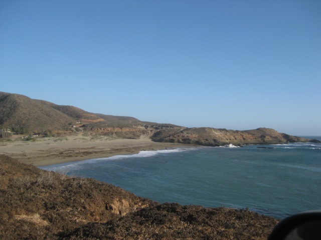
3.7 Road right 0.3 mi to a rocky beach with an impressive cliff, Acantilado los Candeleros ("Cliff Candlestick"). See photo.
7.2 & 7.4 Driveways to Rancho Lazaro, in Arroyo Lazaro.
11.5 Los Morros, here a home is surrounded by a white picket fence.
12.5 Steep grade up. 4WD recommended here and for the next 8 miles south.
18.2 Steep grade up.
19.5 Big grade down.
20.2 Big grade down.
24.6 Junction with the Cataviña/Faro San José graded road. Go right for the coast. The road to the left goes 19.4 miles where it meets the inland,
abandoned road, from Mile 2.0 (above). From there it continues 26 additional miles to Highway 1 at Km. 168, (46 miles from the fish camp, San José).
25.5 Road left is the road to continue south to Bahía Córbin and beyond, bypassing the fish camp of San José.
25.6 Take the road left, over the hill, into the fish camp of San José. Faro San José or San José de la Piedra are how signs and maps label this
place. A road to the right (north) here goes 0.3 mile to a rocky beach. The road straight ahead goes to the beach just west of the San José fish
camp.
25.7 San José fish camp, no advertised services. Just beyond the homes, this road ends at the beach in 0.1 mile. A small island is offshore.
Reset odometer to zero at the fish camp to continue with the road log going south.
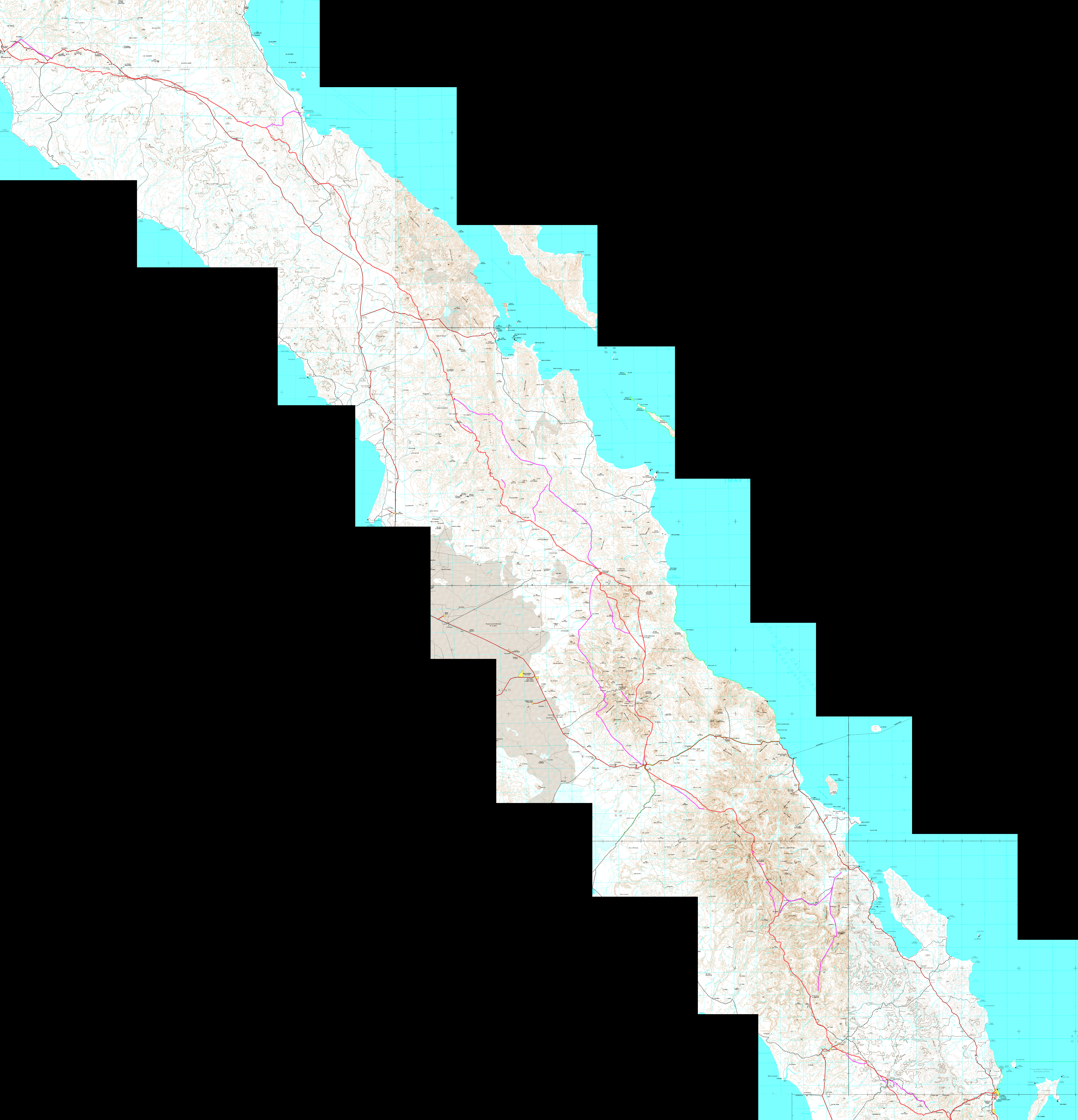
Maps for this part of the guide:

|
|
|
PNWers
Newbie
Posts: 10
Registered: 2-9-2023
Member Is Offline
|
|
Thank you both!
|
|
|
| Pages:
1
2 |
|


