David K
Honored Nomad

Posts: 65556
Registered: 8-30-2002
Location: San Diego County
Member Is Offline
Mood: Have Baja Fever
|
|
March 2025 Baja Bound Bulletin Article about Mission San José del Cabo +
The March bulletin has just been published...
GregN has a very interesting article about Nellie Cashman and the gold mines:
https://www.bajabound.com/bajaadventures/bajafever/nellie_ca...
My article on the mission: https://www.bajabound.com/bajaadventures/bajatravel/mission_...
The whole bulletin with more articles: https://www.bajabound.com/mail/view.php?vc=1a74e4eef039903d2...
|
|
|
cupcake
Senior Nomad
Posts: 828
Registered: 4-23-2024
Member Is Offline
|
|
Excellent! Thanks for posting these links, David!
Nellie was a looker! And tough as nails. She must have met Wyatt Erp and his friends while in Tombstone.
[Edited on 3-13-2025 by cupcake]
|
|
|
cupcake
Senior Nomad
Posts: 828
Registered: 4-23-2024
Member Is Offline
|
|
Great article on the southern most missions, David!
Interesting that the Pericu women favored polygamy. Maybe too much work involved with monogamy.
It's nice to see the old photos of Mission San Jose del Cabo and Mission Todos Santos (seen via the first linkout). Too bad these two old structures
are no longer existing.
[Edited on 3-14-2025 by cupcake]
|
|
|
David K
Honored Nomad
Posts: 65556
Registered: 8-30-2002
Location: San Diego County
Member Is Offline
Mood: Have Baja Fever
|
|
Quote: Originally posted by cupcake  | Great article on the southern most missions, David!
Interesting that the Pericu women favored polygamy. Maybe too much work involved with monogamy.
It's nice to see the old photos of Mission San Jose del Cabo and Mission Todos Santos (seen via the first linkout). Too bad these two old structures
are no longer existing.
[Edited on 3-14-2025 by cupcake] |
Thank you!
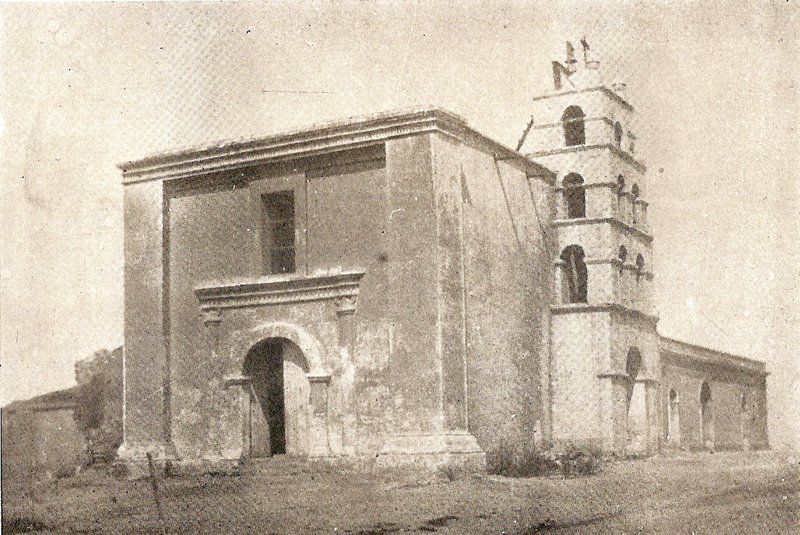
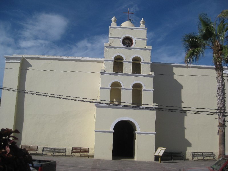
Comparing the 1919 Todos Santos photo to the building seen today at the town plaza... very little change on the north and east sides. What do you
think? It is pretty surprising, yes?
1919:
2017:

|
|
|
cupcake
Senior Nomad
Posts: 828
Registered: 4-23-2024
Member Is Offline
|
|
Is this the original structure? If yes, is it a cut-stone constructed building? It looks remarkably good. I thought the only cut-stone survivors were
between (and including) San Borja and San Luis Gonzaga.
|
|
|
David K
Honored Nomad
Posts: 65556
Registered: 8-30-2002
Location: San Diego County
Member Is Offline
Mood: Have Baja Fever
|
|
| Quote: Originally posted by cupcake | Is this the original structure? If yes, is it a cut-stone constructed building? It looks remarkably good. I thought the only cut-stone survivors were
between (and including) San Borja and San Luis Gonzaga.
|
Original Jesuit (1697-1767) buildings or parts of building, yes, you are correct. What you see at Todos Santos was or replaced what the Dominican
priest had built there, in 1825 to 1840 (when the mission was closed).
Do you have my book or seen my article?: https://www.bajabound.com/bajaadventures/bajatravel/la_paz_m...
As you may know from my Baja Bound article, there were two missions at Todos Santos, which began as a visita of the La Paz mission in 1725. The first
mission was called Santa Rosa (1733-1748), it was located in front of the 1970 modern church, a mile north of the town plaza (no ruins, just a
playground).
The La Paz mission moved from the bay location to the Mission Santa Rosa/ Visita Todos Santos location (from 1748-1825). That final year (1825), it
moved south to where the church in the above photos is (today's town plaza).
In the spring of 1822, Baja California officially became part of the newly independent Mexican Empire. The Spanish missions were no more...
However, with still many Natives not yet assimilated to modern living, many missions were allowed to remain open (at least until their priest
abandoned it or died). The La Paz mission (at Todos Santos) was operating to 1840, when it became a parish church serving the newly arrived Mexican
people.
What I don't have is if that 1825 moved mission's church was modified or replaced with what we see in the 1919 photo.
In 1868, this was a sketch made at Todos Santos... obviously not the exact same building of the 1919 photo:

|
|
|
cupcake
Senior Nomad
Posts: 828
Registered: 4-23-2024
Member Is Offline
|
|
David, That is amazing. So, it looks like the building that can be seen today is much the same as what was there in 1919. But, sometime between 1868
and 1919 there were some major changes to the structure. I wondered if there had been any earthquakes in the area, during this time period, that could
have caused some damage and maybe necessitated some building changes. I didn't find anything that looked major for Todos Santo or La Paz, but
reportedly Loreto was largely destroyed by an earthquake in 1878.
In 1910, there was an earthquake near La Paz, which is thought capable of having caused moderate shaking in Todos Santos. Linked report of this event:
https://www.volcanodiscovery.com/earthquakes/quake-info/8914...
In the 1919 photo of Mission Todos Santos, the building looks old (to my eyes). It maybe looks older than it would, if it had been built in or after
1906, so maybe maybe it had already attained its 1919 appearance before the quake in 1906.
I do have your book on the Baja Missions (current edition), and I will go back and read the section on Todos Santos.
|
|
|
David K
Honored Nomad
Posts: 65556
Registered: 8-30-2002
Location: San Diego County
Member Is Offline
Mood: Have Baja Fever
|
|
Super... the current building may have roots with the 1868 sketch? Hurricanes (at least in 1918 in San José del Cabo) did a lot of damage, too.
Read both Mission #7 (La Paz) and #13 (Santa Rosa) for that location.
|
|
|
4x4abc
Ultra Nomad
Posts: 4455
Registered: 4-24-2009
Location: La Paz, BCS
Member Is Offline
Mood: happy - always
|
|
the Nellie story got me thinking
all discovery sites needed access routes
transportation for gear and food
who supplied the food
let's focus on Calmalli
the routes should still be visible since they had more traffic than ECR and 100 years younger than ECR
the route Nellie was talked into (La Trinidad as a starting point) was a suicide route - one of the driest areas in Baja
the rumor that she made it to Santa Gertrudis made me think that Santa Gertrudis was a major food supplier for Calmalli (and later El Arco)
the later established route to Calmalli started at El Barril
the 3 story Casona Ybarra is testament of that fact
now all of the sudden a route between El Barril and Santa Gertrudis that I found some years ago makes sense
from El Barril to Santa Gertrudis as reliable water source and place for provisions before moving on to Calmalli
Bahia de los Angeles may also have been a starting point to reach Calmalli
with that in mind, the Gulf Route of Camino Real as a mining trail starts to make sense (before that I always doubted the Jesuits would have 3
different routes to reach San Borja)
so, the Gulf Route may have been a miners trail
Bahia de los Angeles, Las Flores, San Pedro, Calmalli (or El Barril if so needed)
Rancho Miraflores may also have been a food supplier
and Rancho Prosperidad may have been a beef producer for Calmalli/El Arco
Boleo was always my first thought - but it is a bit far away
so many new possibilities!
I'll leave you with a couple of sections of that El Barril-Santa Gertrudis trail
Attachment: 1 Santa Gertrudis - El Barril.kmz (2kB)
This file has been downloaded 193 times
Attachment: 2 Santa Gertrudis - El Barril.kmz (2kB)
This file has been downloaded 181 times
Attachment: 3 Santa Gertrudis - El Barril .kmz (3kB)
This file has been downloaded 176 times
Attachment: 4 Santa Gertrudis - El Barril .kmz (2kB)
This file has been downloaded 177 times
Attachment: 5 Santa Gertrudis - El Barril.kmz (3kB)
This file has been downloaded 176 times
Attachment: 6 Santa Gertrudis - Santa Agueda.kmz (10kB)
This file has been downloaded 177 times
Attachment: 7 Santa Gertrudis - Santa Agueda.kmz (10kB)
This file has been downloaded 181 times
Attachment: 8.kmz (8kB)
This file has been downloaded 178 times
[Edited on 3-15-2025 by 4x4abc]
Harald Pietschmann
|
|
|
4x4abc
Ultra Nomad
Posts: 4455
Registered: 4-24-2009
Location: La Paz, BCS
Member Is Offline
Mood: happy - always
|
|
just a tip - set your time slider in Google Earth to 2003 for the El Barril - Santa Gertrudis trail
the last 20 years have not been kind to that trail
Harald Pietschmann
|
|
|


