David K
Honored Nomad

Posts: 65565
Registered: 8-30-2002
Location: San Diego County
Member Is Offline
Mood: Have Baja Fever
|
|
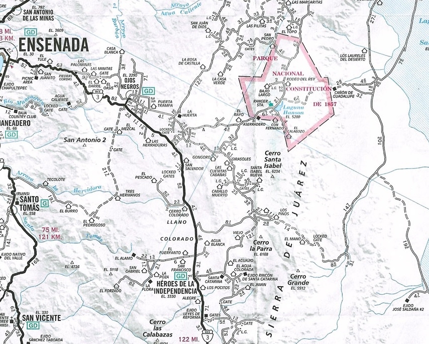
A look back to June 2003: Baja 500 and down Mano to Guadalupe Canyon
Details from June 2003 trip
Guadalupe Canyon from Hwy. 3, going down the mountain
Last June, after watching the Baja 500 race with my son, https://vivabaja.com/p500/ we continued east to drop off the Sierra Juarez to the desert below, then turned north to camp at Guadalupe Canyon Hot
Springs.
The road is shown in the AAA Baja map and Baja Almanac topo map book 2003 Baja Almanac You may follow along with either, but the Almanac offers superior details, although not totally accurate.
My GPS waypoints are at map datum setting NAD27 Mexico (same as the Almanac).
On the AAA map, note the following ranchos: Agua Blanca (just east of Hwy. 3, opposite the road to El Alamo); Los Pinos; Cerro Prieto; El Mano; and
the 'Locked Gate' (it's not).
We followed the race course (not on maps) from Hwy. 3 to a point just north of Agua Blanca and made camp near a cross road, where the race course
turned left/east. Our camp near this crossroad was at 31°42.24', -115°54.75' elev. 4,005'.
After the race, we followed the course from that 'left turn' and went up CAÑADA LAS CODORNICES 5.2 miles (map 8, R-1, Baja Almanac) to...
A junction near ARROYO EL TULE at 31°45.20', -115°51.52' elev. 4,663' (Almanac page 6, R-6, bottom edge) The race course turned right (south) here,
we continued ahead.
The main traveled road eventually curves eastward through the forest (not shown in Almanac).
Road again turns north at 31°47.89', -115°49.25', elev. 5,009'. We just followed the road with visual signs having the most traffic, going the
general direction we sought, and it took us the right way.
Soon the road turned to the east, and we arrived at the big RANCHO LOS PINOS (shown on AAA map, but not the Almanac) at 31°48.77', -115°46.26',
elev. 5,086'. The peak CERRO PRIETO is just north of the ranch. Drive right through ranch property, going east.
Road curves north passing the north side of RANCHO CERRO PRIETO (31°49.23', -115°45.34') then turns east (not shown in Almanac continuing east).
Great view looking north along the east side of Sierra Juarez, down CANON EL PALMAR 31°49.12', -115°43.01'.
Road climbs a ridge and then drops into the upper end of CANON EL MANO for a long, steep down grade. Painted arrows (graffiti) on boulders from SCORE
indicates this was a race course, in the past.
RANCHO EL MANO is seen down in the canyon near some palms, driveway at 31°48.56', -115°40.39' near canyon floor.
The road will climb out of El Mano canyon, over the north ridge. Some concrete was dumped for improved traction on a steep pitch. The 'Locked Gate' on
the AAA map is a steel cable gate and was not locked or even closed.
The road descends the remaining slopes of the Sierra Juarez and is quite rough heading for the desert floor.
Once at the bottom, the road heads east to a junction with a faint road that continues south along the foot of the sierra, at 31°49.81',
-115°33.89', elev. 1,271' Turn north, following the arroyo.
COHABUZO JUNCTION 31°55.74', -115°36.22', elev. 860'. This point is not named on the map, but is the name used by off road racers (Located to the
east of the airplane symbol in the Almanac, and east of Cerro Cohabuzo in the AAA map). Here is a large level area where pit teams can service their
racers. A poor road and race route goes east to the Laguna Salada basin, joins a good road to Ejido Saldana, and reaches Highway 5 (midway between
Mexicali and San Felipe).
From Cohabuzo Junction north to Guadalupe Canyon's access is a fast graded road. Cohabuzo to Guadalupe is 29 miles.
Our Baja 500 camp (near Agua Blanca) to Cohabuzo was 36 miles, but don't be in a hurry... this is a great short cut in miles, but not in driving time!
Have a great Baja adventure!
[Edited on 3-28-2025 by David K]
|
|
|
advrider
Super Nomad
Posts: 1924
Registered: 10-2-2015
Member Is Offline
|
|
Did this route last month in two jeeps with small trailers. Not for the faint of heart or ill-prepared. Took us 2.5 day from the hot springs to make
it to Hwy 3.
The sand in the washes was very deep and the road gone in several sections. The climb out past the ranches is very bad shape now, most dirt has been
washed from the rock and is close to the Rubicon trail in sections(I've run it about 40 times).
In one spot on the steep climb the bank has slid into the road, a shelf road on the side of a 100 plus foot drop. Two hops and my right front tire
was hanging off of the edge. Some creative winching saved us, but this trail is no walk in the park now, many washouts that drop into bottomless
crevasses.
It was fun, but this is very remote with little chance of rescue, go prepared. The large rock steps and exposed boulders would not be much fun on a
moto unless it was a small two stroke in my opinion, gas might be an issue too.
|
|
|
PaulW
Ultra Nomad
Posts: 3113
Registered: 5-21-2013
Member Is Offline
|
|
2.5 days is very long. Should have been one long day IMO. Detail where the slowest part of the trip was.
Last drive for your route exposed Arroyo Enmedio with its deep soft sand.
My trip over Mano was filled with issues. Found how to bypass (100foot drop) where the shelf road was washed out.
My last trip required driving thru the Los Pinos compound thru two closed gated and a second ranch, but his gates were not closed. Not good.
Did you bypass those two ranches using the over the mountain to the north?
=== =
Quote: Originally posted by advrider  | Did this route last month in two jeeps with small trailers. Not for the faint of heart or ill-prepared. Took us 2.5 day from the hot springs to make
it to Hwy 3.
The sand in the washes was very deep and the road gone in several sections. The climb out past the ranches is very bad shape now, most dirt has been
washed from the rock and is close to the Rubicon trail in sections(I've run it about 40 times).
In one spot on the steep climb the bank has slid into the road, a shelf road on the side of a 100 plus foot drop. Two hops and my right front tire
was hanging off of the edge. Some creative winching saved us, but this trail is no walk in the park now, many washouts that drop into bottomless
crevasses.
It was fun, but this is very remote with little chance of rescue, go prepared. The large rock steps and exposed boulders would not be much fun on a
moto unless it was a small two stroke in my opinion, gas might be an issue too. |
|
|
|
Ken Cooke
Elite Nomad
Posts: 8971
Registered: 2-9-2004
Location: Riverside, CA
Member Is Offline
Mood: Pole Line Road postponed due to injury
|
|
| Quote: Originally posted by PaulW | 2.5 days is very long. Should have been one long day IMO. Detail where the slowest part of the trip was.
Last drive for your route exposed Arroyo Enmedio with its deep soft sand.
My trip over Mano was filled with issues. Found how to bypass (100foot drop) where the shelf road was washed out.
My last trip required driving thru the Los Pinos compound thru two closed gated and a second ranch, but his gates were not closed. Not good.
Did you bypass those two ranches using the over the mountain to the north?
=== =
| Quote: Originally posted by advrider | Did this route last month in two jeeps with small trailers. Not for the faint of heart or ill-prepared. Took us 2.5 day from the hot springs to make
it to Hwy 3.
The sand in the washes was very deep and the road gone in several sections. The climb out past the ranches is very bad shape now, most dirt has been
washed from the rock and is close to the Rubicon trail in sections(I've run it about 40 times).
In one spot on the steep climb the bank has slid into the road, a shelf road on the side of a 100 plus foot drop. Two hops and my right front tire
was hanging off of the edge. Some creative winching saved us, but this trail is no walk in the park now, many washouts that drop into bottomless
crevasses.
It was fun, but this is very remote with little chance of rescue, go prepared. The large rock steps and exposed boulders would not be much fun on a
moto unless it was a small two stroke in my opinion, gas might be an issue too. |
|
The time I led a group up this route, it was extremely steep, but our group of short wheelbase Jeeps made short work of the stairstep section that was
so steep in sections, I could not read the trail. All I saw out of my windshield was blue sky, the 100ft+ drop-off to our right and the dirt wall on
the drivers side. I was in 1st gear, 4 low the entire section and too nervous to stop. My friend Victor told me that was, "harder than the Rubicon"
and his experience of a lifetime. I was just glad that we didn't get stuck because I was nervous the entire time going up.
|
|
|
AKgringo
Elite Nomad
Posts: 6359
Registered: 9-20-2014
Location: Anchorage, AK (no mas!)
Member Is Online
Mood: Retireded
|
|
Sounds like I can scratch that route from the list of possible adventures in my Honda Element!
If you are not living on the edge, you are taking up too much space!
"Could do better if he tried!" Report card comments from most of my grade school teachers. Sadly, still true!
|
|
|
David K
Honored Nomad
Posts: 65565
Registered: 8-30-2002
Location: San Diego County
Member Is Offline
Mood: Have Baja Fever
|
|
GPS edits
Just realized that this format: COHABUZO JUNCTION 31°55.74'/ 115°36.22'
is not friendly for Google Maps/ Satellite viewing.
I just edited the 2003 post to this format for all the GPS waypoints: COHABUZO JUNCTION 31°55.74', -115°36.22
Without the - with the 115°, you are in China (East vs West longitude).
Then replacing the / with a comma allows you to easily see a satellite view: Highlight the waypoint with your mouse.
Right click on the highlight.
Choose Search Google For.
Click on the small map to make it full size, and click layers unless the satellite image is already showing.
[Edited on 3-28-2025 by David K]
|
|
|
advrider
Super Nomad
Posts: 1924
Registered: 10-2-2015
Member Is Offline
|
|
We didn't do super long days as were enjoying the drive even with the challenging terrain. We stopped well before dark and made dinner each night.
You could probably do it in a long day and a half, but I think you would still be on trial in the dark. I would not want to climb out past the two
ranches in the dark. Not pulling a trailer would be faster as well.
As Ken pointed out, there is very little room for error once you start making the climb out of the canyon. I'll pull out my map and try to add
more details to this post.
|
|
|
David K
Honored Nomad
Posts: 65565
Registered: 8-30-2002
Location: San Diego County
Member Is Offline
Mood: Have Baja Fever
|
|
| Quote: Originally posted by advrider | We didn't do super long days as were enjoying the drive even with the challenging terrain. We stopped well before dark and made dinner each night.
You could probably do it in a long day and a half, but I think you would still be on trial in the dark. I would not want to climb out past the two
ranches in the dark. Not pulling a trailer would be faster as well.
As Ken pointed out, there is very little room for error once you start making the climb out of the canyon. I'll pull out my map and try to add
more details to this post. |
That would be great... and you are so lucky to not be in a hurry.
I would love to travel the peninsula at a slower rate to check out more sites and to just relax on some isolated beaches. All my travels in 2017 and
18 were pretty rapid to get as many miles covered as possible. I really wore myself out, but am so glad I had the opportunity to revisit places and
see new places I had not been to, before.
|
|
|
advrider
Super Nomad
Posts: 1924
Registered: 10-2-2015
Member Is Offline
|
|
We retired a few years ago so this was our first month long, no hard-set return date Baja trip. Really enjoyed not having to be in a rush and just
stay where we felt comfortable and move on when we wanted.
We did whale watching with Shari with amazing results. We had six whales approach our boat and hangout for over an hour. When we moved off because
another boat moved in, they followed us. Crazy cool, I'll work on some pictures of that and the rest of the trip.
Hard to find time right now as we are headed to Utah to ride bikes, then back to Utah in a month with the RZR. Then about a month to rest and we
are off to Alaska on our Adventure bikes for a month or so. Trying to get the most out of retirement...
|
|
|
David K
Honored Nomad
Posts: 65565
Registered: 8-30-2002
Location: San Diego County
Member Is Offline
Mood: Have Baja Fever
|
|
| Quote: Originally posted by advrider | We retired a few years ago so this was our first month long, no hard-set return date Baja trip. Really enjoyed not having to be in a rush and just
stay where we felt comfortable and move on when we wanted.
We did whale watching with Shari with amazing results. We had six whales approach our boat and hangout for over an hour. When we moved off because
another boat moved in, they followed us. Crazy cool, I'll work on some pictures of that and the rest of the trip.
Hard to find time right now as we are headed to Utah to ride bikes, then back to Utah in a month with the RZR. Then about a month to rest and we
are off to Alaska on our Adventure bikes for a month or so. Trying to get the most out of retirement... |
Living the good life! I am happy for you...
We have been fully retired for almost a year and planned to begin traveling... Alas, just over a year ago, my wife's mother (then was 90) had a bad
fall, and could no longer walk easily, cook, drive, or live without full time care. So, she lives with us. We play cards and watch TV with her. I
enjoy Baja via Nomad and Baja Facebook groups (I operate two, VivaBaja and BajaMissions).
|
|
|
David K
Honored Nomad
Posts: 65565
Registered: 8-30-2002
Location: San Diego County
Member Is Offline
Mood: Have Baja Fever
|
|
If any of you did the Google satellite map look at my waypoints, you will notice that the marker is about 100 feet east of the actual location (a fork
in the road, a ranch, etc.). This is because my waypoints back then were all set at Map Datum NAD27 Mexico (as the Mexican topos were drawn at).
Google Satellite maps are at Map Datum WGS84 (which is what GPS devices are factory set at).
With a Nomad's great assistance, all my VivaBaja.com waypoints (at NAD27) were converted to WGS84.
Here is my Viva Baja GPS list, of this trip, but going from Guadalupe Canyon up to Hwy. 3:
Guadalupe Canyon Entrance: 32°09.40′, -115°47.34′
Cohabuzo Jcn: 31°55.74′, -115°36.27′
Ej. Saldaña Road (S): 31°50.12′, -115°19.52′
Hwy. 5 & Ej. Saldaña Jcn: 31°51.75′, -115°10.97′
South of Cohabuzo 8.2 mi. is a fork, go right for El Mano (4WD): 31°49.81′, -115°33.94′
Jcn. with road to left. Ahead-right goes up the mountain via El Mano canyon: 31°47.68′, -115°36.70′
Rancho El Mano driveway left, road begins major climb: 31°48.56′, -115°40.44′
Rancho Los Pinos, elev. 5,086′: 31°48.77′, -115°46.31′
Jcn. Santa Catarina left (S)/ Agua Blanca right (SW): 31°45.20′, -115°51.57′
Jcn. Agua Blanca left (S), Hwy. 3 right (N): 31°42.24′, -115°54.30′
See them all: https://vivabaja.com/gps/
[Edited on 3-29-2025 by David K]
|
|
|
PaulW
Ultra Nomad
Posts: 3113
Registered: 5-21-2013
Member Is Offline
|
|
What we all need is a real track. as opposed to a historical one like David posted.
1) For the route from Cohabuzo that avoids Los Pinos and the other Ranch and their gates by using the mountain bypass for the ranches.
2) The approach to the bottom of the Mano Hill from Enmedio after the last hurricane.
I have a track but it is from Google Earth and I have not driven.
|
|
|
advrider
Super Nomad
Posts: 1924
Registered: 10-2-2015
Member Is Offline
|
|
This is the track I used;
all gates were open, and we drove past both ranches. The road was lost in two washes but was straight across the wash in both cases. It might have
been you (PaulW) that posted some pointers on the track that I posted before I left, it was very helpful in keeping us on track. Trying to find that
original post
[Edited on 3-30-2025 by advrider]
[Edited on 3-30-2025 by advrider]
[Edited on 3-30-2025 by advrider]
Attachment: Hot springs -HWY-3.gpx (8kB)
This file has been downloaded 186 times
|
|
|
AKgringo
Elite Nomad
Posts: 6359
Registered: 9-20-2014
Location: Anchorage, AK (no mas!)
Member Is Online
Mood: Retireded
|
|
Alaska bound?
| Quote: Originally posted by advrider |
Hard to find time right now as we are headed to Utah to ride bikes, then back to Utah in a month with the RZR. Then about a month to rest and we
are off to Alaska on our Adventure bikes for a month or so. Trying to get the most out of retirement... |
So you are headed to my old stomping grounds! Have you made the trip before?
I don't want to hijack this thread, but I may have some useful suggestions if you have any questions.
If you are not living on the edge, you are taking up too much space!
"Could do better if he tried!" Report card comments from most of my grade school teachers. Sadly, still true!
|
|
|
David K
Honored Nomad
Posts: 65565
Registered: 8-30-2002
Location: San Diego County
Member Is Offline
Mood: Have Baja Fever
|
|
It's okay, hijack away!
|
|
|
advrider
Super Nomad
Posts: 1924
Registered: 10-2-2015
Member Is Offline
|
|
Yes, hijack away. I went one time 20 years ago fishing from AK to Homer in a rented motorhome. Amazing place, this trip will be all moto, probably
little to no fishing. Depending on weather, part camping and part hotels. I'll take any advice anyone has.
We talked about taking the ferry back to Washington, but at 2k for five days with a room we might just ride it all. On one hand I think the ferry
sounds fun and will give a cool perspective, but not sure at this point.
|
|
|
mtgoat666
Platinum Nomad
Posts: 21100
Registered: 9-16-2006
Location: San Diego
Member Is Offline
Mood: Hot n spicy
|
|
| Quote: Originally posted by advrider | Yes, hijack away. I went one time 20 years ago fishing from AK to Homer in a rented motorhome. Amazing place, this trip will be all moto, probably
little to no fishing. Depending on weather, part camping and part hotels. I'll take any advice anyone has.
We talked about taking the ferry back to Washington, but at 2k for five days with a room we might just ride it all. On one hand I think the ferry
sounds fun and will give a cool perspective, but not sure at this point. |
When i did the ferry i slept on the deck in a sleeping bag. Cheap if they still allow such.
Woke!
Hands off!
“Por el bien de todos, primero los pobres.”
“...ask not what your country can do for you – ask what you can do for your country.” “My fellow citizens of the world: ask not what America
will do for you, but what together we can do for the freedom of man.”
Pronoun: the royal we
|
|
|
advrider
Super Nomad
Posts: 1924
Registered: 10-2-2015
Member Is Offline
|
|
They do allow it, and I was thinking of that as well, might be an option. You can even put your tent up and duct tape it down.
|
|
|
|


