| Pages:
1
2
3 |
Lance S.
Nomad

Posts: 237
Registered: 2-16-2021
Member Is Offline
|
|
Trippy spot on Google Earth
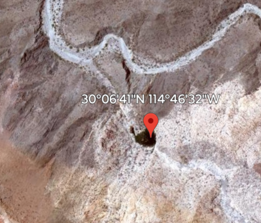
Look at different image dates.
Does it line up with any names on old maps?
30°06'41"N 114°46'32"W
[Edited on 6-16-2025 by Lance S.]
|
|
|
Lance S.
Nomad
Posts: 237
Registered: 2-16-2021
Member Is Offline
|
|

|
|
|
mtgoat666
Platinum Nomad
Posts: 21088
Registered: 9-16-2006
Location: San Diego
Member Is Offline
Mood: Hot n spicy
|
|
Looks like a spring. Perhaps a small pool of water, but hard to tell as images are poor resolution.
Woke!
Hands off!
“Por el bien de todos, primero los pobres.”
“...ask not what your country can do for you – ask what you can do for your country.” “My fellow citizens of the world: ask not what America
will do for you, but what together we can do for the freedom of man.”
Pronoun: the royal we
|
|
|
StuckSucks
Super Nomad
Posts: 2376
Registered: 10-17-2013
Location: Pacific Plate
Member Is Offline
|
|
The crosshairs mark the spot on the right side of the images, and it is located in an arroyo, so I argue that we are looking at nothing more than a
shadow in a canyon. But only one way to find out ...


|
|
|
Tioloco
Elite Nomad
Posts: 6028
Registered: 7-30-2014
Member Is Offline
|
|
Looks like a shadow on my end but not 100 percent sure of it.
Am looking at it on iphone.
[Edited on 6-16-2025 by Tioloco]
|
|
|
Lance S.
Nomad
Posts: 237
Registered: 2-16-2021
Member Is Offline
|
|
Here's a couple more
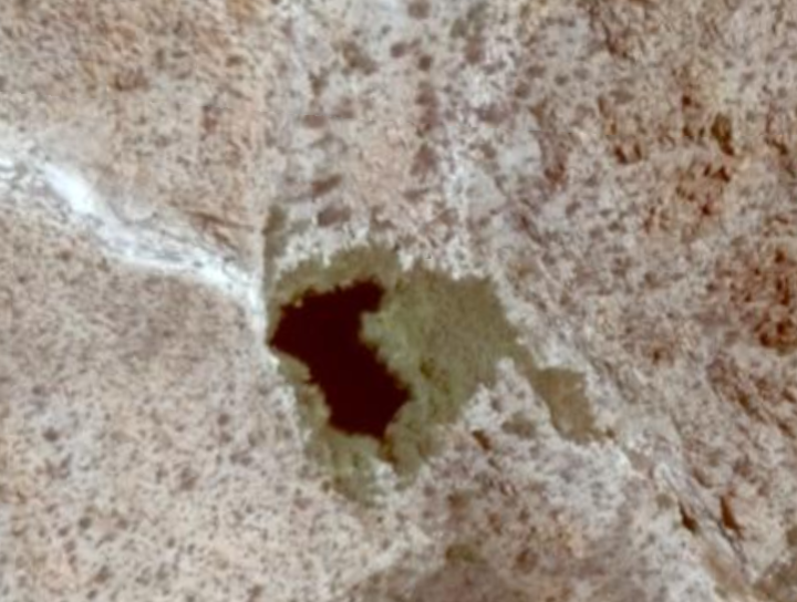 image hosting websites image hosting websites
|
|
|
mtgoat666
Platinum Nomad
Posts: 21088
Registered: 9-16-2006
Location: San Diego
Member Is Offline
Mood: Hot n spicy
|
|
If google images are showing true colors, then might be seeing some green vegetation, which usually indicates a source of shallow moisture that cattle
have invariably turned into a mud hole…
Woke!
Hands off!
“Por el bien de todos, primero los pobres.”
“...ask not what your country can do for you – ask what you can do for your country.” “My fellow citizens of the world: ask not what America
will do for you, but what together we can do for the freedom of man.”
Pronoun: the royal we
|
|
|
Lance S.
Nomad
Posts: 237
Registered: 2-16-2021
Member Is Offline
|
|
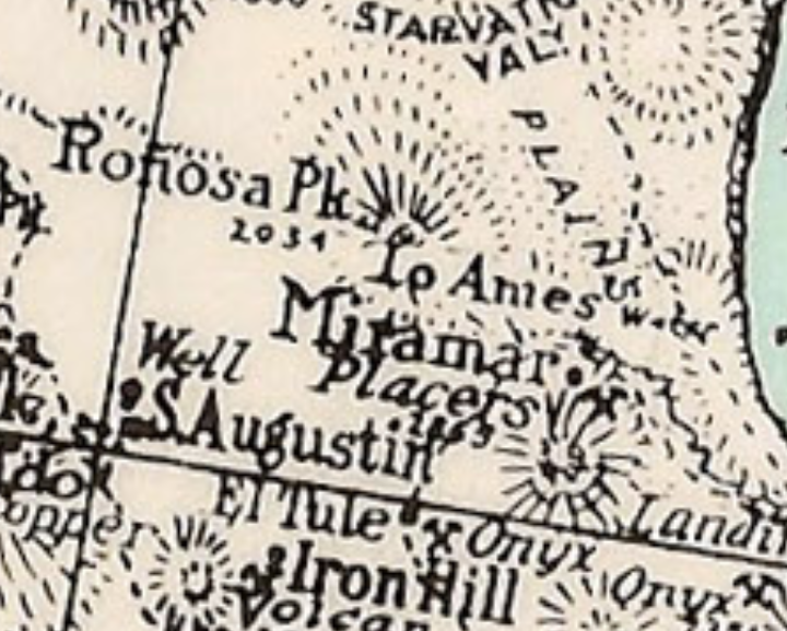
There is a spot marked Ames on the Knight map a little north of Miramar. Looks like it says there is water. Maybe we can find Ronosa peak.
[Edited on 6-17-2025 by Lance S.]
|
|
|
David K
Honored Nomad
Posts: 65562
Registered: 8-30-2002
Location: San Diego County
Member Is Offline
Mood: Have Baja Fever
|
|
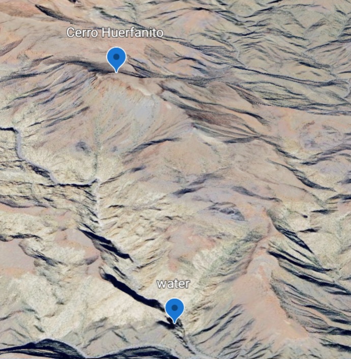
Many arroyos have tinajas or springs. This is just north of the San Judas Onyx Mine we recently visited. Note 'onyx' on the map, lower right corner...
below 'Landing' ( future Okie Landing, but in 1930 was the Miramar Landing.
EDIT: got on my PC and using your GPS waypoint then placing that on the various maps (INEGI topo, Benchmark Baja Atlas, Baja Almanac, Satellite view)
that point is in Arroyo el Placer de los Peralta. The Almanac spelled it 'Perita'.
The location is just north of, and upstream of the merge with Arroyo el Volcán and crosses Mex 5 near Km. 106, just south of El Huerfanito.
The satellite view confirms it is water, as that is seen just downstream of the pond, in the arroyo, next to a shadow from the hill... the shadow is
also over some of the pond, I think.
Harald (4x4abc) is the expert at seeing things on Google Earth, so I look forward to his analysis.
[Edited on 6-17-2025 by David K]
|
|
|
bajaric
Senior Nomad
Posts: 681
Registered: 2-2-2015
Member Is Offline
|
|
I thought that might be Arroyo Perita. Pretty remote area. It makes sense that there is water in a few places in there, similar to the eastern
escarpment of the Sierra Juarez and San Pedro Martir. The mountains in that area have less rain, smaller watershed, but a little water still finds
its way to the surface.
|
|
|
AKgringo
Elite Nomad
Posts: 6357
Registered: 9-20-2014
Location: Anchorage, AK (no mas!)
Member Is Offline
Mood: Retireded
|
|
Perita?
Is that Spanish for a small female dog?
If you are not living on the edge, you are taking up too much space!
"Could do better if he tried!" Report card comments from most of my grade school teachers. Sadly, still true!
|
|
|
Lance S.
Nomad
Posts: 237
Registered: 2-16-2021
Member Is Offline
|
|
Did you guys see any named peaks nearby?
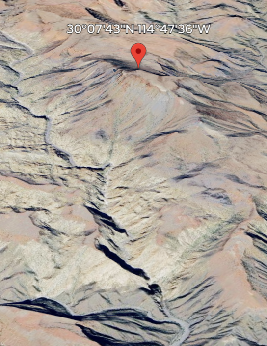
The Knight map shows Ronosa peak at 2034 ft but the 1948 geology map has it at 2934 ft. This peak right near the water is around 2900 ft.
30°07'43"N 114°47'36"W
[Edited on 6-17-2025 by Lance S.]
|
|
|
Timo1
Senior Nomad
Posts: 764
Registered: 11-2-2007
Location: Homeless
Member Is Offline
Mood: Lovin every minute of it
|
|
Small female puppy
sold out and got out !!!
|
|
|
Lance S.
Nomad
Posts: 237
Registered: 2-16-2021
Member Is Offline
|
|
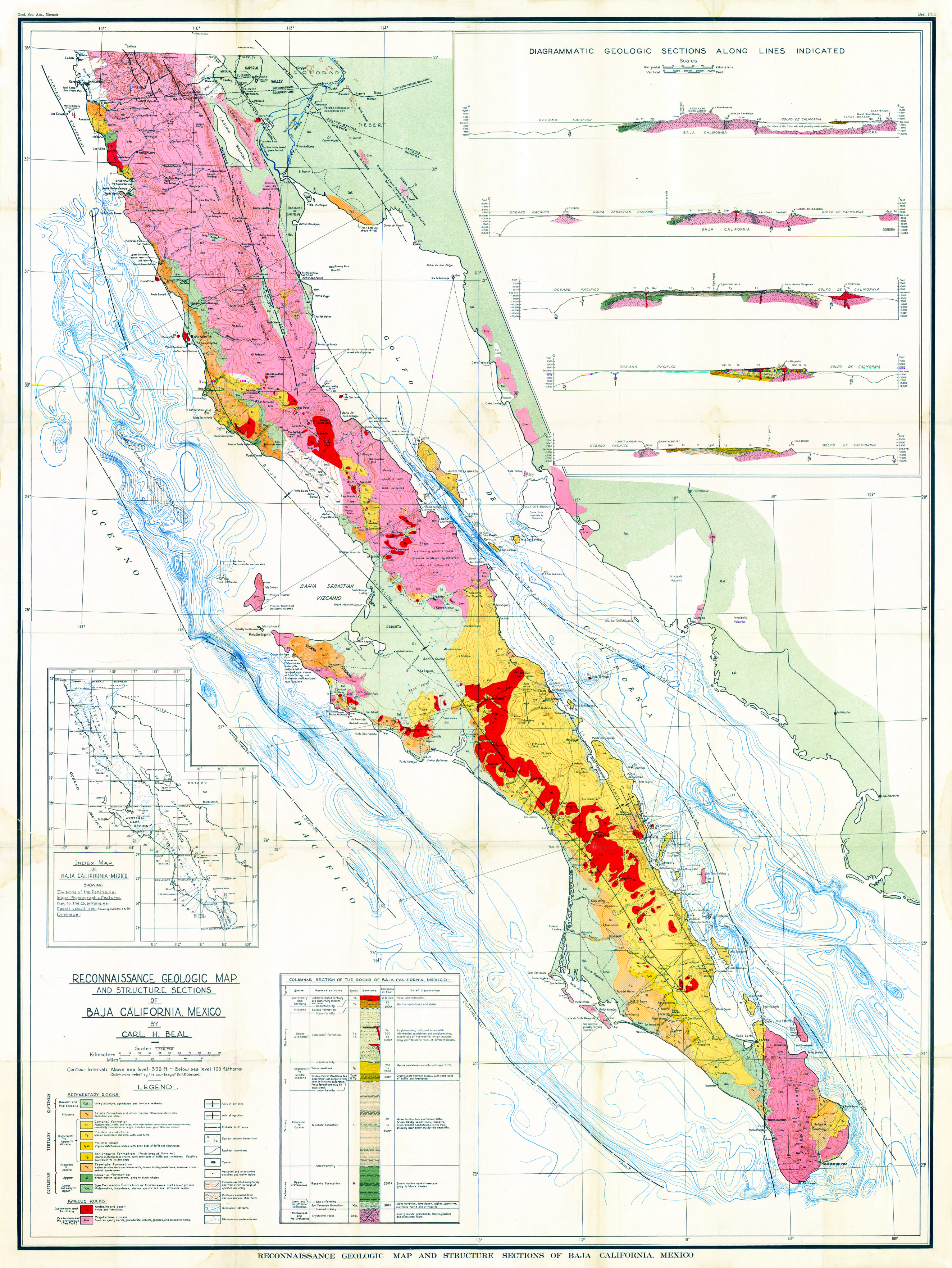
The three peaks with arrows on the geology map. The northern one is Cerro Canelo, the middle is labeled Ronosa on the Knight map, the southern one I
don't know.
https://octopup.org/img/media/maps/baja/1948--Baja-Californi...
[Edited on 6-17-2025 by Lance S.]
|
|
|
Lance S.
Nomad
Posts: 237
Registered: 2-16-2021
Member Is Offline
|
|
Quote: Originally posted by Lance S.  | Did you guys see any named peaks nearby?
The Knight map shows Ronosa peak at 2034 ft but the 1948 geology map has it at 2934 ft. This peak right near the water is around 2900 ft.
30°07'43"N 114°47'36"W
[Edited on 6-17-2025 by Lance S.] |
OK I figured it out. That is Cerro El Huerfanito. Knight has it marked as Ronosa. Perhaps the water is called Tinaja or Aguaje El Huerfanito .
[Edited on 6-18-2025 by Lance S.]
|
|
|
David K
Honored Nomad
Posts: 65562
Registered: 8-30-2002
Location: San Diego County
Member Is Offline
Mood: Have Baja Fever
|
|
Before seeing your last reply, I was going to say Cerro el Huerfanito, as it was the only peak that showed up near the spot, on the maps I was looking
at. El Huerfanito is the island near the shore, all alone, the little orphan. Not sure why a spring, out-of-view of it would have its name? The peak,
sure... I think the INEGI map also is named for the Little Orphan Island.
|
|
|
Lance S.
Nomad
Posts: 237
Registered: 2-16-2021
Member Is Offline
|
|
Cerro El Huerfanito is so close to the water
I suspect that the only reason that little peak is named is because it was used as a landmark to find the water.
[Edited on 6-18-2025 by Lance S.]
|
|
|
Lance S.
Nomad
Posts: 237
Registered: 2-16-2021
Member Is Offline
|
|
|
|
|
Lance S.
Nomad
Posts: 237
Registered: 2-16-2021
Member Is Offline
|
|
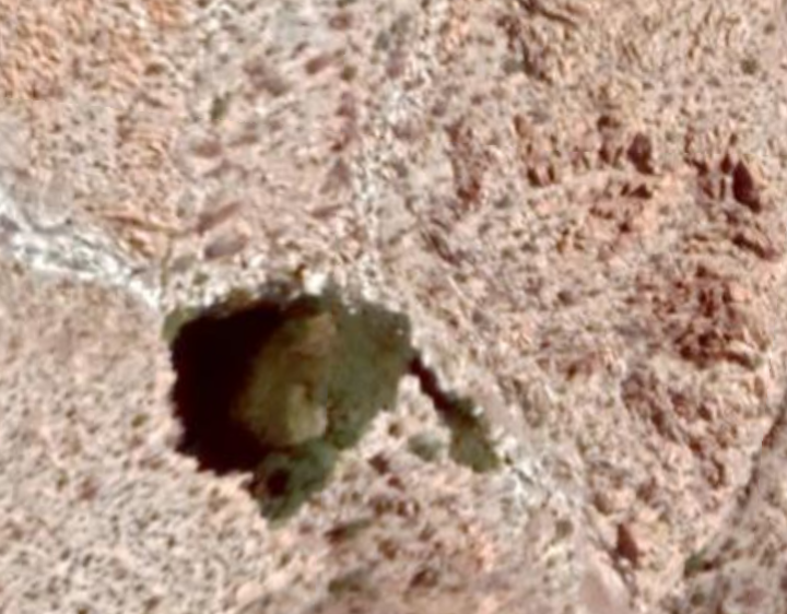
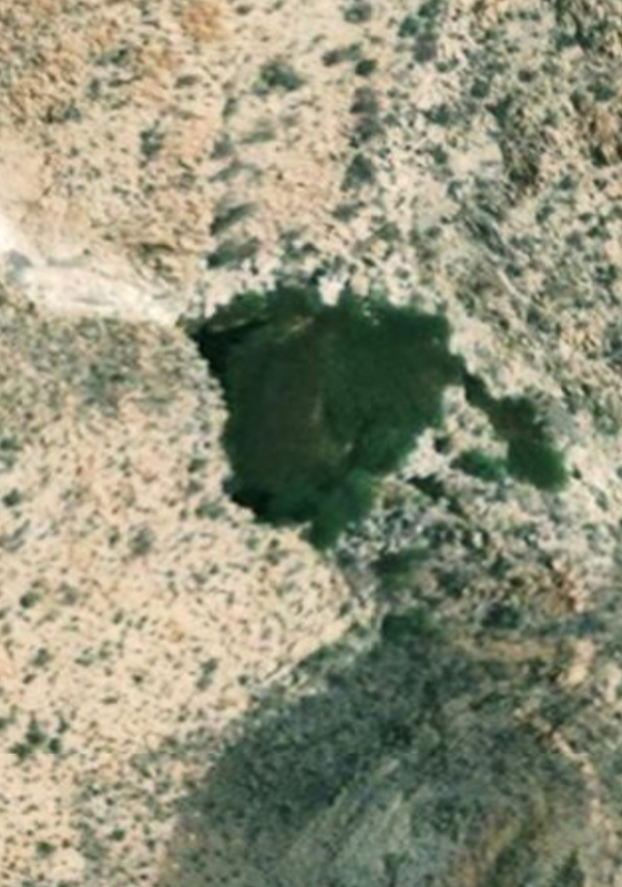
The arroyo drops off just before the pool so it is probably a large tinaja, about 150 feet across when full.
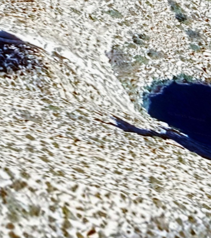
Looks like it may fill with Tule between rains. Good source for balsas, edible as well.
[Edited on 6-18-2025 by Lance S.]
|
|
|
4x4abc
Ultra Nomad
Posts: 4455
Registered: 4-24-2009
Location: La Paz, BCS
Member Is Offline
Mood: happy - always
|
|
| Quote: Originally posted by Lance S. |
Look at different image dates.
Does it line up with any names on old maps?
30°06'41"N 114°46'32"W
[Edited on 6-16-2025 by Lance S.] |
great find!
I had it listed a a spring - but the latest sat images show a natural dam and a pool that is sometimes full
the 2023 images show a large water outflow
Harald Pietschmann
|
|
|
| Pages:
1
2
3 |


