| Pages:
1
2
3 |
4x4abc
Ultra Nomad

Posts: 4455
Registered: 4-24-2009
Location: La Paz, BCS
Member Is Offline
Mood: happy - always
|
|
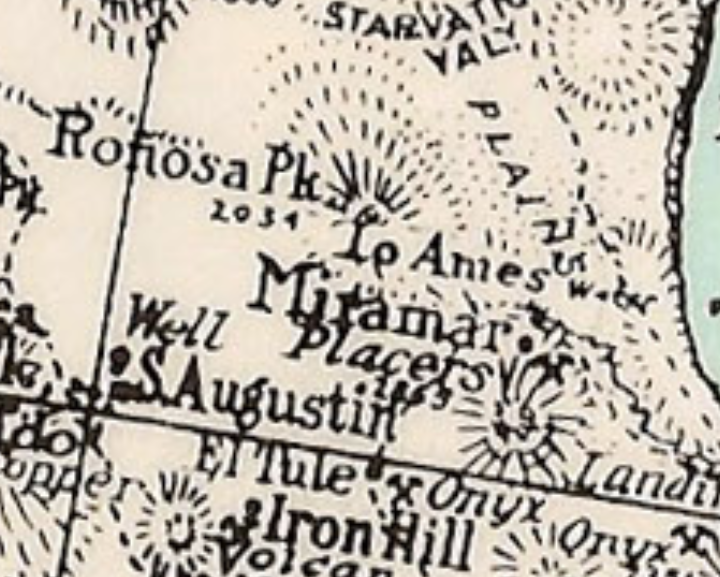
Quote: Originally posted by Lance S.  | There is a spot marked Ames on the Knight map a little north of Miramar. Looks like it says there is water. Maybe we can find Ronosa peak.
[Edited on 6-17-2025 by Lance S.] |
Renosa Peak seems to be Cerro El Huerfanito
Harald Pietschmann
|
|
|
Lance S.
Nomad
Posts: 237
Registered: 2-16-2021
Member Is Offline
|
|
Maybe a spring fed tinaja?
Could be that most of the pool is always there but it fills with tule so the satellite images are deceiving.
Here's a tiny isolated palm grove no to far away.
30°06'32"N 114°49'13"W
[Edited on 6-18-2025 by Lance S.]
|
|
|
Lance S.
Nomad
Posts: 237
Registered: 2-16-2021
Member Is Offline
|
|
https://www.researchgate.net/figure/Location-of-waterholes-i...
Number six or thirteen?
[Edited on 6-19-2025 by Lance S.]
|
|
|
David K
Honored Nomad
Posts: 65562
Registered: 8-30-2002
Location: San Diego County
Member Is Offline
Mood: Have Baja Fever
|
|
Very cool map!
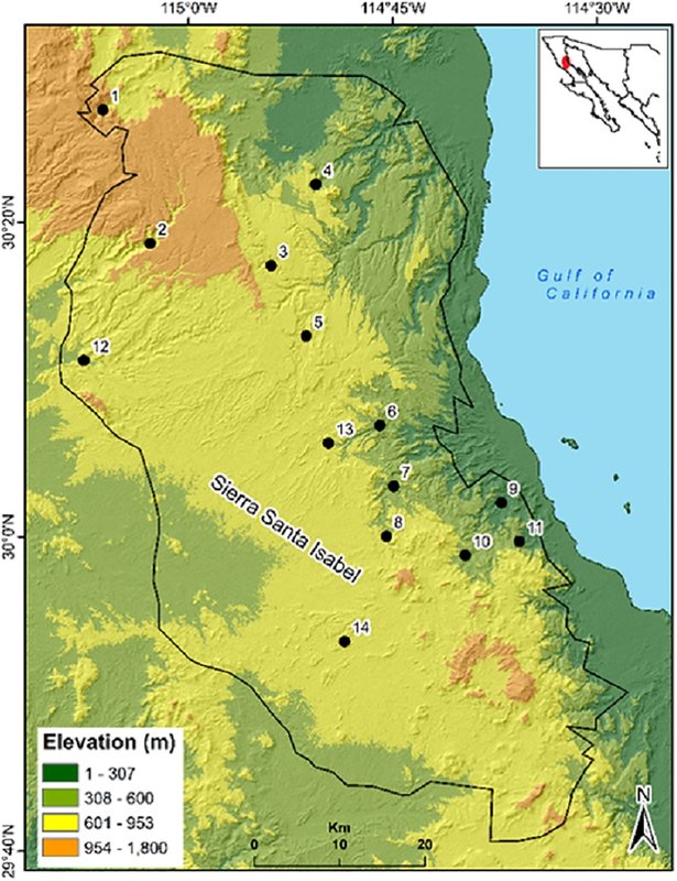
Location of waterholes in Sierra Santa Isabel, Baja California 1. Matomi, 2. Grande, 3. Las Blancas, 4. Canelo, 5. Hemes, 6. Zamora, 7.
Cordero, 8. Volcán, 9. Miramar, 11. Palmito, 12. San Agustín, 13. Peralta, 14. Dulce.
|
|
|
Lance S.
Nomad
Posts: 237
Registered: 2-16-2021
Member Is Offline
|
|
Aquaje El Zamora, a year round spring with a surface area of 907.9 square meters.
A couple of photos taken at Zamora here
https://www.actauniversitaria.ugto.mx/index.php/acta/article...
[Edited on 6-19-2025 by Lance S.]
|
|
|
4x4abc
Ultra Nomad
Posts: 4455
Registered: 4-24-2009
Location: La Paz, BCS
Member Is Offline
Mood: happy - always
|
|
| Quote: Originally posted by David K |
Very cool map!
Location of waterholes in Sierra Santa Isabel, Baja California 1. Matomi, 2. Grande, 3. Las Blancas, 4. Canelo, 5. Hemes, 6. Zamora, 7.
Cordero, 8. Volcán, 9. Miramar, 11. Palmito, 12. San Agustín, 13. Peralta, 14. Dulce.
|
waterhole #10 does not have a name
Harald Pietschmann
|
|
|
geoffff
Senior Nomad
Posts: 721
Registered: 1-15-2009
Member Is Offline
|
|
#6, Zamora!
Here I tried to line it up with Benchmark map
|
|
|
geoffff
Senior Nomad
Posts: 721
Registered: 1-15-2009
Member Is Offline
|
|
There is an unmapped road which passes a location 5 miles northwest of the waterhole (30.136982, -114.834486) where you could hike in along the
arroyo.
|
|
|
4x4abc
Ultra Nomad
Posts: 4455
Registered: 4-24-2009
Location: La Paz, BCS
Member Is Offline
Mood: happy - always
|
|
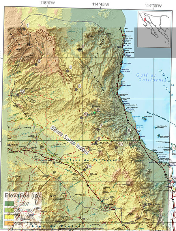
#6 - Peralta is the Tinaja in the first image
I made an overlay in Google Earth with the map
it is a very crude map, but I was able to assign most locations
Cordero 30.044018°, -114.755267°
Peralta 30.093165°, -114.819974°
Zamora 30.111337°, -114.775772°
Hemes 30.222022°, -114.864314°
Volcan 29.993757°, -114.770407°
#10 29.971006°, -114.678188°
Miramar 30.026986°, -114.629470°
Palmito 29.990187°, -114.598430°
Dulce 29.883126°, -114.823547°
Canelo ?
Las Blancas ?
Grande ?
San Agustin ?
[Edited on 6-19-2025 by 4x4abc]
Harald Pietschmann
|
|
|
Lance S.
Nomad
Posts: 237
Registered: 2-16-2021
Member Is Offline
|
|
Thank you Geoffff and Harald!
So the unnamed number ten is Àguaje Sagrado..
Harald, where did you get that name?
[Edited on 6-19-2025 by Lance S.]
|
|
|
David K
Honored Nomad
Posts: 65562
Registered: 8-30-2002
Location: San Diego County
Member Is Offline
Mood: Have Baja Fever
|
|
| Quote: Originally posted by Lance S. | Thank you Geoffff and Harald!
So the unnamed number ten is Àguaje Sagrado..
Harald, where did you get that name?
[Edited on 6-19-2025 by Lance S.] |
The little palm oasis of Sargado is up the arroyo (Agua las Palmitas), 2.5 miles from San Judas (onyx mine near km. 119): 29.9854, -114.6082
The name Sargado is on the INEGI topo map... and their map shows it as couple of structures about 400 meters downstream from the oasis location (as
seen on satellite imagery). Another error on the topo map is showing the spring about 300 meters upstream of where it actually is.
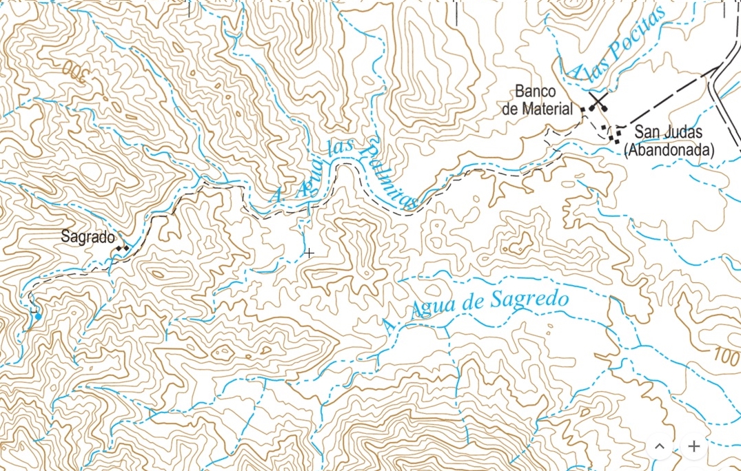
[Edited on 6-19-2025 by David K]
|
|
|
geoffff
Senior Nomad
Posts: 721
Registered: 1-15-2009
Member Is Offline
|
|
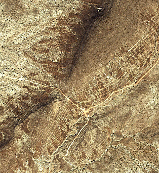
Any idea why there are so many new unmapped roads in that area, west of #6 and Cerro el Huerfanito?
Are these mining exploration roads?
It looks like they were bulldozed somewhere between 2009 and 2014
|
|
|
geoffff
Senior Nomad
Posts: 721
Registered: 1-15-2009
Member Is Offline
|
|
A bit to the southwest there are a whole web of roads. I bet Harald knows what this is. 30.0657,-114.8876
|
|
|
4x4abc
Ultra Nomad
Posts: 4455
Registered: 4-24-2009
Location: La Paz, BCS
Member Is Offline
Mood: happy - always
|
|
#10 is 5 miles away from Agua Sagrado - Agua Palmito is farther to the east
#10 is in an Arroyo that has a lot of waterholes
the white blobs represent water holes

Harald Pietschmann
|
|
|
4x4abc
Ultra Nomad
Posts: 4455
Registered: 4-24-2009
Location: La Paz, BCS
Member Is Offline
Mood: happy - always
|
|
| Quote: Originally posted by geoffff | A bit to the southwest there are a whole web of roads. I bet Harald knows what this is. 30.0657,-114.8876
|
yes, I do know
it is a government reforestation project
usually found on larger properties
you gotta have staff that is able to apply for the money
you gotta have personnel and machines to do the work
I know of about 30 different projects in Baja

Harald Pietschmann
|
|
|
4x4abc
Ultra Nomad
Posts: 4455
Registered: 4-24-2009
Location: La Paz, BCS
Member Is Offline
Mood: happy - always
|
|
the new roads and tracks seem to be related to prospecting
there is no water in the area to allow for ranch projects
one of them is growing NE every few years - seems like they eventually want to connect to Matomi wash and MEX5
they have reached the highest point of the Mesa by now with some exploratory dozer track heading down - it's a 500ft drop
the white track is the Bill Nichols MC track

there is a similar attempt east of Guerrero Negro connecting to a new real estate project with a very wide new road to Bahia San Carlos (great beach!)
road example here: 27.830340°, -113.016532° (the white line)

Harald Pietschmann
|
|
|
4x4abc
Ultra Nomad
Posts: 4455
Registered: 4-24-2009
Location: La Paz, BCS
Member Is Offline
Mood: happy - always
|
|
you are right, David
the spring location on the INEGI map is off

Harald Pietschmann
|
|
|
geoffff
Senior Nomad
Posts: 721
Registered: 1-15-2009
Member Is Offline
|
|
| Quote: Originally posted by 4x4abc | yes, I do know
it is a government reforestation project
usually found on larger properties
you gotta have staff that is able to apply for the money
you gotta have personnel and machines to do the work
I know of about 30 different projects in Baja
|
Whoa! I wouldn't have guessed it! Thanks, Harald
|
|
|
geoffff
Senior Nomad
Posts: 721
Registered: 1-15-2009
Member Is Offline
|
|
| Quote: Originally posted by 4x4abc | there is a similar attempt east of Guerrero Negro connecting to a new real estate project with a very wide new road to Bahia San Carlos (great beach!)
road example here: 27.830340°, -113.016532° (the white line)
|
Bahia San Carlos does look nice! I remember you passed through that area a while back on your No Wimps Trail, Harald.
I was just pondering if I could get myself all the way out there driving north from Alfredo V Bonfil when I spotted an elaborate airstrip there at
27.855152,-112.770566 (now ditched)
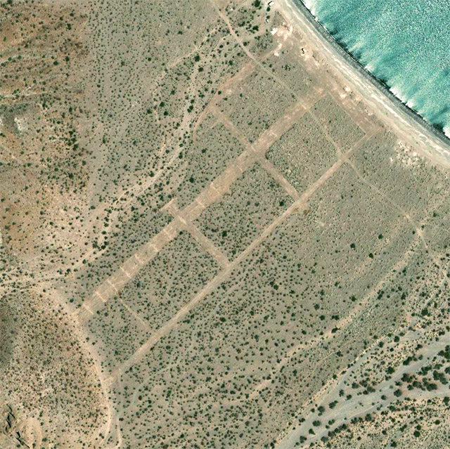
And a very fresh airstrip on the beach at 27.847668,-112.760579 It's not even visible on Google Earth yet. Check out Bing Maps satellite
I guess that means the access road is nice and well maintained!
Not so sure I should go there.
[Edited on 6-20-2025 by geoffff]
|
|
|
PaulW
Ultra Nomad
Posts: 3113
Registered: 5-21-2013
Member Is Offline
|
|
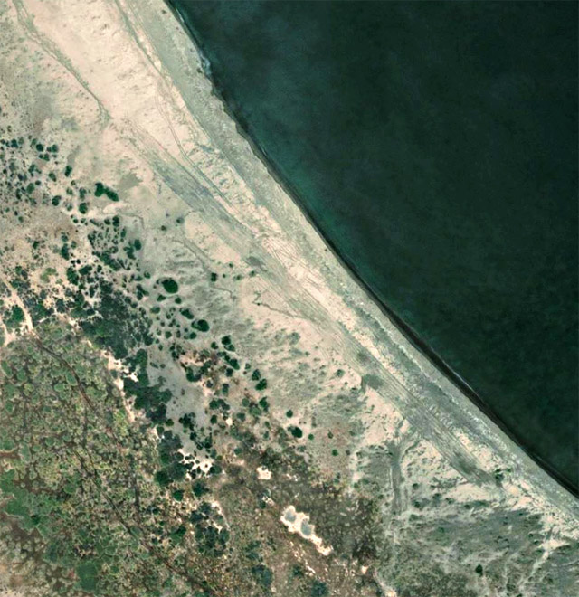
What do you all suppose this is at 27 53.716, -112 46.088
I was never able to drive past the locked gate back when and now I see a large marine project.
North of the landing strip along the Wimps track.

|
|
|
| Pages:
1
2
3 |


