| Pages:
1
2
3
4 |
pauldavidmena
Super Nomad

Posts: 1870
Registered: 5-23-2013
Location: Centerville, MA, USA
Member Is Offline
|
|
A Facebook friend in Todos Santos mentioned getting four inches of rain in an hour on Saturday (September 6th).
|
|
|
AKgringo
Elite Nomad
Posts: 6442
Registered: 9-20-2014
Location: Anchorage, AK (no mas!)
Member Is Online
Mood: Retireded
|
|
The storm probably wiped out the road over the pass through the Los Naranjos Ranch again. I like that road, and would appreciate any recent info
about it.
If you are not living on the edge, you are taking up too much space!
"Could do better if he tried!" Report card comments from most of my grade school teachers. Sadly, still true!
|
|
|
pauldavidmena
Super Nomad
Posts: 1870
Registered: 5-23-2013
Location: Centerville, MA, USA
Member Is Offline
|
|
I haven't read any specific reports about roads in BCS, but this article in the Gringo Gazette mentions 5 people being rescued from overflowing arroyos in Los Cabos.
|
|
|
pauldavidmena
Super Nomad
Posts: 1870
Registered: 5-23-2013
Location: Centerville, MA, USA
Member Is Offline
|
|
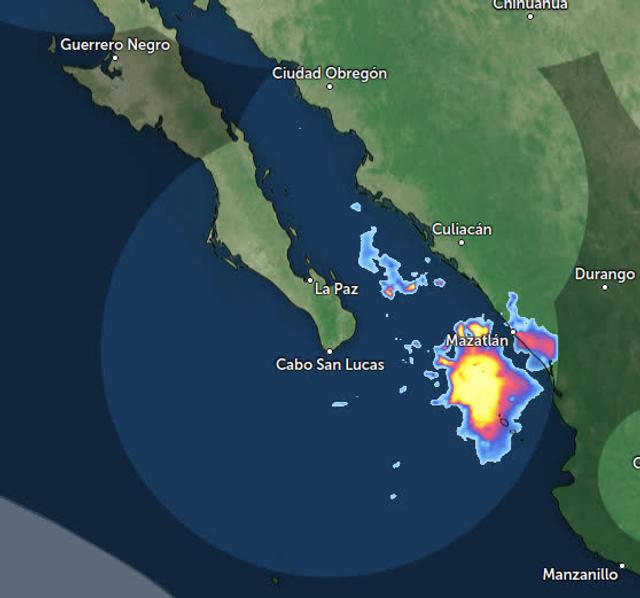
Marie is long gone, but some warm Gulf moisture will continue to influence BCS weather over the next few days.
|
|
|
Don Jorge
Senior Nomad
Posts: 696
Registered: 8-29-2003
Member Is Offline
|
|
An interesting tropical depression is forecast to form this weekend offshore of Mexico. What makes it interesting, at least from my perspective, is
it appears to not be on an east to west parh as previously named storms behaved going out to sea away from Mexico and specifically Baja. Worth
observing.
�And it never failed that during the dry years the people forgot about the rich years, and during the wet years they lost all memory of the dry
years. It was always that way.�― John Steinbeck
"Until a person learns to respect nature and talk to the animal world, he will never know his true role on Earth." Enzo Mallorca
"Nature bats last." Doug "Hayduke" Peac-ck
|
|
|
chippy
Super Nomad
Posts: 1822
Registered: 2-2-2010
Member Is Offline
|
|
Quote: Originally posted by Don Jorge  | | An interesting tropical depression is forecast to form this weekend offshore of Mexico. What makes it interesting, at least from my perspective, is
it appears to not be on an east to west parh as previously named storms behaved going out to sea away from Mexico and specifically Baja. Worth
observing. |
Yeah Windy models show it hitting the coast of Col/Jal on wens. as a tropical storm or more. Looks like I´ll be going down to Melaque to "batten down
the hatches". Hopefully it doesn't wreak havoc like Patricia did.
[Edited on 9-19-2026 by chippy]
|
|
|
pauldavidmena
Super Nomad
Posts: 1870
Registered: 5-23-2013
Location: Centerville, MA, USA
Member Is Offline
|
|
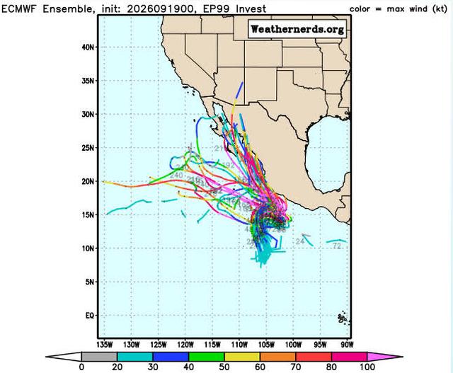
This "spaghetti model" from Weathernerds.com shows the potential for Invest EP99 to impact Baja. The hurricane season is far from over!
Edit: for some reason the image from postimg.cc doesn't seem to be uploading. I will continue to troubleshoot until I can get it working.
Edit #2: The image finally uploaded.
[Edited on 9-19-2026 by pauldavidmena]
[Edited on 9-19-2026 by pauldavidmena]
|
|
|
AKgringo
Elite Nomad
Posts: 6442
Registered: 9-20-2014
Location: Anchorage, AK (no mas!)
Member Is Online
Mood: Retireded
|
|
The current Windy model shows the storm traveling up the Pacific side of the cape and possibly coming ashore mi-way up the coast, about a week from
now!
If you are not living on the edge, you are taking up too much space!
"Could do better if he tried!" Report card comments from most of my grade school teachers. Sadly, still true!
|
|
|
chippy
Super Nomad
Posts: 1822
Registered: 2-2-2010
Member Is Offline
|
|
It has again changed to going up the mainland coast and into the sea of Cortez while tropical storm Odalys takes a hard right and is heading towards
Baja. Wonder what tomorrow will bring
|
|
|
SFandH
Elite Nomad
Posts: 7683
Registered: 8-5-2011
Member Is Offline
|
|
| Quote: Originally posted by chippy | | It has again changed to going up the mainland coast and into the sea of Cortez while tropical storm Odalys takes a hard right and is heading towards
Baja. Wonder what tomorrow will bring |
That agrees with the ECMWF weather model, the Windy.com default model, and the ICON model. They show the storm entering the Sea of Cortez this coming
Friday. The GFS model shows the storm due south of Cabo at a safe distance on the same day.
Windy.com offers predictive, time-lapse animated graphics for all three models.
We'll see....
[Edited on 9-20-2026 by SFandH]
|
|
|
Don Jorge
Senior Nomad
Posts: 696
Registered: 8-29-2003
Member Is Offline
|
|
Fujiwhara Effect
Interesting indeed the guidance models have changed.
Would not be surprised to see a Fujiwhara Effect this season in the Eastern Pacific.
�And it never failed that during the dry years the people forgot about the rich years, and during the wet years they lost all memory of the dry
years. It was always that way.�― John Steinbeck
"Until a person learns to respect nature and talk to the animal world, he will never know his true role on Earth." Enzo Mallorca
"Nature bats last." Doug "Hayduke" Peac-ck
|
|
|
SFandH
Elite Nomad
Posts: 7683
Registered: 8-5-2011
Member Is Offline
|
|
| Quote: Originally posted by Don Jorge | Interesting indeed the guidance models have changed.
Would not be surprised to see a Fujiwhara Effect this season in the Eastern Pacific.
|
Had to google that. I guess that would complicate predictions.
|
|
|
Don Jorge
Senior Nomad
Posts: 696
Registered: 8-29-2003
Member Is Offline
|
|
Officially a depression. Translated says
Watch closely, a major is forming and as of now do not know where or if it will make landfall. Thought we could all practice some Spanish why we wait
and wait and wait...yup stole that from Casablanca. Jaja
Depresión Tropical Seventeen-E Discusión Especial Número 1
Centro Nacional de Huracanes del SNM Miami FL EP172026
300 PM CST domingo 20 de septiembre de 2026
La perturbación tropical al sur de México, anteriormente llamada
Invest 99E, está mejor organizada, con algunas bandas convectivas en
Watch closely. Gonna be a major next week and right now we dont know its exact route.
su semicírculo este. Aunque un paso reciente del dispersómetro no
hizo circulación, los movimientos de nubes bajas indican que el
sistema ahora tiene suficiente circulación de bajo nivel como para
calificar como depresión tropical, con una intensidad inicial de 30
kt esta advertencia.
Hasta ahora ha sido difícil de rastrear, por lo que el movimiento
inicial es de 030/7 kt. Según la mayoría de las previsiones de
trayectoria, es probable que el sistema gire hacia el este en las
próximas 12 a 24 horas. Aparentemente, este movimiento se debe a que
el sistema se encuentra incrustado en un giro ciclónico más amplio
cerca de la costa sur de México. Más adelante en el período de
pronóstico, se espera que el sistema gire hacia el noroeste y se
mueva hacia el sur de una máxima de nivel medio. El pronóstico
oficial se sitúa cerca del lado norte de la envolvente del modelo de
guía.
La depresión debería situarse dentro de un entorno propicio para su
fortalecimiento durante los próximos días, con una ligera
cizalladura del viento vertical y temperaturas muy altas en la
superficie del mar. El pronóstico de intensidad oficial está cerca
del consenso del modelo y muestra que el sistema se convertirá en un
huracán en 36 horas. Cabe señalar que las previsiones de Google
DeepMind y HCCA prevén un huracán más fuerte de lo que se muestra en
este pronóstico inicial.
Mensajes clave:
1. Las fuertes lluvias asociadas con la Depresión Tropical 17-E
afectarán las porciones costeras del suroeste de México esta
semana.Esta lluvia podría producir inundaciones y deslizamientos de
tierra que amenazan la vida, especialmente en áreas de terreno
empinado.
2. Se pronostica que la Depresión Tropical 17-E se fortalezca y se
acerque a la costa suroeste de México como huracán mayor a finales
de semana. Aunque es demasiado pronto para determinar la ubicación
exacta o la magnitud de los impactos asociados con el sistema,
México debería seguir de cerca su progreso y las actualizaciones del
pronóstico.
When it gets a name it earns it own thread.
�And it never failed that during the dry years the people forgot about the rich years, and during the wet years they lost all memory of the dry
years. It was always that way.�― John Steinbeck
"Until a person learns to respect nature and talk to the animal world, he will never know his true role on Earth." Enzo Mallorca
"Nature bats last." Doug "Hayduke" Peac-ck
|
|
|
SFandH
Elite Nomad
Posts: 7683
Registered: 8-5-2011
Member Is Offline
|
|
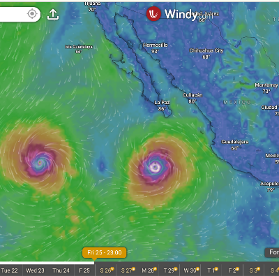
Friday night.......maybe
[Edited on 9-20-2026 by SFandH]
|
|
|
pauldavidmena
Super Nomad
Posts: 1870
Registered: 5-23-2013
Location: Centerville, MA, USA
Member Is Offline
|
|
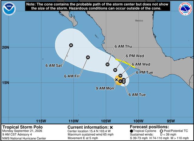
What ever you do, don't shout "Marco!"
|
|
|
CaboMagic
Super Nomad
Posts: 1137
Registered: 4-30-2005
Member Is Offline
|
|
9/23/2026 6:30am
Our port will close today at noon.
Boats that left this morning can return at 'normal' time.
Satellite views (eebmike) show the outflow of Odalys - is being "pulled in" by the ridge from the north.
Edit: Odalys is the storm that was on its way west. This is not activity from Polo.
[Edited on 9-23-2026 by CaboMagic]
|
|
|
pauldavidmena
Super Nomad
Posts: 1870
Registered: 5-23-2013
Location: Centerville, MA, USA
Member Is Offline
|
|
| Quote: Originally posted by CaboMagic | 9/23/2026 6:30am
Our port will close today at noon.
Boats that left this morning can return at 'normal' time.
Satellite views (eebmike) show the outflow of Odalys - is being "pulled in" by the ridge from the north.
Edit: Odalys is the storm that was on its way west. This is not activity from Polo.
[Edited on 9-23-2026 by CaboMagic] |
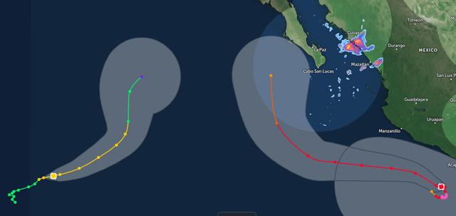
This image from Zoom Earth shows the projected interaction between Odalys and Polo.
|
|
|
CaboMagic
Super Nomad
Posts: 1137
Registered: 4-30-2005
Member Is Offline
|
|
Not sure what argument you are attempting to make PDM
If you look at CURRENT SATELLITE VIEWS you will see what I am referring to. The reason for TODAYS PORT CLOSURE is due to the OUTFLOW from ODALYS NOT
POLO
See you in Cabo.
| Quote: Originally posted by pauldavidmena | | Quote: Originally posted by CaboMagic | 9/23/2026 6:30am
Our port will close today at noon.
Boats that left this morning can return at 'normal' time.
Satellite views (eebmike) show the outflow of Odalys - is being "pulled in" by the ridge from the north.
Edit: Odalys is the storm that was on its way west. This is not activity from Polo.
[Edited on 9-23-2026 by CaboMagic] |
This image from Zoom Earth shows the projected interaction between Odalys and Polo.
|
|
|
|
CaboMagic
Super Nomad
Posts: 1137
Registered: 4-30-2005
Member Is Offline
|
|
https://cdn.star.nesdis.noaa.gov/GOES19/ABI/SECTOR/eep/13/GO...
|
|
|
AKgringo
Elite Nomad
Posts: 6442
Registered: 9-20-2014
Location: Anchorage, AK (no mas!)
Member Is Online
Mood: Retireded
|
|
Thank you Cabomagic for your on the scene feedback! Most of us are contributing from a thousand miles away.
If you are not living on the edge, you are taking up too much space!
"Could do better if he tried!" Report card comments from most of my grade school teachers. Sadly, still true!
|
|
|
| Pages:
1
2
3
4 |






![[*]](images/xmbforum/default_icon.gif)