rts551
Elite Nomad

Posts: 6700
Registered: 9-5-2003
Member Is Offline
|
|
New Road From Tecate HWY Around Ensenada?
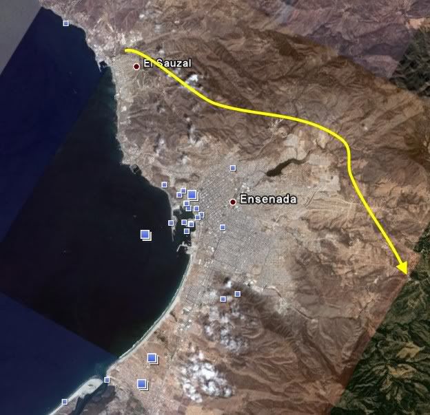
Any one have any info. I have been told by the locals between Ensenada and Tecate that it is part of a 4 lane road being built from Tecate, bypassing
Ensenada, and heading South. See blue line on poor photo

|
|
|
fdt
Ultra Nomad
Posts: 4059
Registered: 9-7-2003
Location: Tijuana, Baja California
Member Is Offline
Mood: Yeah, what if it all goes right
|
|
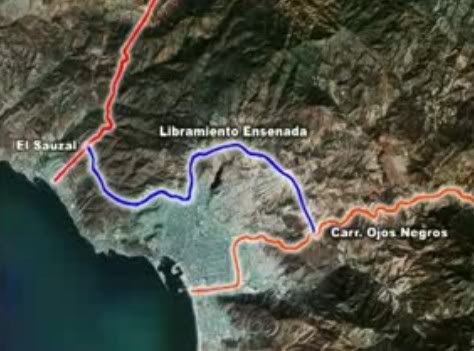
South but not Hwy 1 south, the "Libramiento Ensenada" will go from the Ensenada-Tecate road to meet with the Ensenada-Ojos Negroas road. It will be a
great way to avoid Ensenada totaly say if youre going to Laguna Hanson or San Felipe.
I don't have a map of it but it will be like this
A well informed Baja California traveler is a smart Baja California traveler!
|
|
|
rts551
Elite Nomad
Posts: 6700
Registered: 9-5-2003
Member Is Offline
|
|
Thanks FDT. Do you know if the State has a website explaining their major road/infrastructure projects?
|
|
|
DENNIS
Platinum Nomad
Posts: 29510
Registered: 9-2-2006
Location: Punta Banda
Member Is Offline
|
|
| Quote: | Originally posted by fdt
South but not Hwy 1 south, the "Libramiento Ensenada" will go from the Ensenada-Tecate road to meet with the Ensenada-Ojos Negroas road. It will be a
great way to avoid Ensenada totaly say if youre going to Laguna Hanson or San Felipe.
I don't have a map of it but it will be like this
|
Thanks, Ferna.
Let me see...Merging into the Ojos Negro highway will put southbound traffic back onto Hwy 1 just south of the Big Gigante/Soriana unless they plan to
continue a new road south. Gawd..I hope they do. That would be a mess although it will relieve pressure within the city.
|
|
|
David K
Honored Nomad
Posts: 65512
Registered: 8-30-2002
Location: San Diego County
Member Is Offline
Mood: Have Baja Fever
|
|
Take a closer look at that billboard Ferna... that proposed road is heading beyond the Ojos Negros highway and towards Santo Tomas (the blurry image
shows it east of Maneadero... which is well south of Hwy. 3, and going south of the entrance to San Carlos Canyon... This could be GOOD!!!
|
|
|
Katiejay99
Nomad
Posts: 429
Registered: 9-3-2008
Location: Todos Santos
Member Is Offline
Mood: it is what it is
|
|
Here is a You Tube video (in Spanish) about it.
http://www.youtube.com/watch?v=7VJRKG-C1aMhttp://www.youtube.com/watch?v=7VJRKG-C1aM
Here is the official info about it (in Spanish but has a couple of maps)
http://www.bajacalifornia.gob.mx/informe/1er_informe/des_urbano.htmhttp://www.bajacalifornia.gob.mx/informe/1er_informe/des_urb...
|
|
|
rts551
Elite Nomad
Posts: 6700
Registered: 9-5-2003
Member Is Offline
|
|
This board is up on the intersection of the new road and the Tecate HWY.
Take a look.
As I went by you could not stop because of the construction. Thus the image - driving, windshield, etc Would be nice to know timeframes etc
|
|
|
fdt
Ultra Nomad
Posts: 4059
Registered: 9-7-2003
Location: Tijuana, Baja California
Member Is Offline
Mood: Yeah, what if it all goes right
|
|
| Quote: | Originally posted by David K
Take a closer look at that billboard Ferna... that proposed road is heading beyond the Ojos Negros highway and towards Santo Tomas (the blurry image
shows it east of Maneadero... which is well south of Hwy. 3, and going south of the entrance to San Carlos Canyon... This could be GOOD!!!
|
No David, it does not go to Hwy 1 or Santo Tomas.
A well informed Baja California traveler is a smart Baja California traveler!
|
|
|
fdt
Ultra Nomad
Posts: 4059
Registered: 9-7-2003
Location: Tijuana, Baja California
Member Is Offline
Mood: Yeah, what if it all goes right
|
|
| Quote: | Originally posted by DENNIS
Let me see...Merging into the Ojos Negro highway will put southbound traffic back onto Hwy 1 just south of the Big Gigante/Soriana
|
Nope, It will end way east of the city, nowere close to Hwy 1 and no Soriana that I know of there, maybe when all the housing starts.
A well informed Baja California traveler is a smart Baja California traveler!
|
|
|
DENNIS
Platinum Nomad
Posts: 29510
Registered: 9-2-2006
Location: Punta Banda
Member Is Offline
|
|
| Quote: | Originally posted by fdt
| Quote: | Originally posted by DENNIS
Nope, It will end way east of the city, nowere close to Hwy 1 and no Soriana that I know of there, maybe when all the housing starts.
|
OK...I'm lost and confused.
When it hits the road to Ojos, does it cross and continue on it's new path or does it join the road, as in merge, and follow it past the cement plant,
along the river to its end as I described. |
|
|
|
DENNIS
Platinum Nomad
Posts: 29510
Registered: 9-2-2006
Location: Punta Banda
Member Is Offline
|
|
Jeezo...Look at the mess I made up there. I won't try to fix it.
|
|
|
David K
Honored Nomad
Posts: 65512
Registered: 8-30-2002
Location: San Diego County
Member Is Offline
Mood: Have Baja Fever
|
|
Ferna, the billboard is what I am looking at... the 'proposed' road shown on it is well south of Hwy. 3 and straight east of Punta Banda/ Maneadero.
That billboard map is oriented with east on top (not north).
With the Colonet port, a highway around Ensenada IS needed... and it would be great for everyone else, too!
|
|
|
Dave
Elite Nomad
Posts: 6005
Registered: 11-5-2002
Member Is Offline
|
|
And another detour worth noting
The el Tigre road, connecting Mex 3 in Valley Guadalupe with Mex 1 south of la Mision, has been blacktopped. Used to be a washboard mess...Now
smoooth. 
It's no longer necessary to drive to Ensenada and then back up Mex 3 to the valley.
|
|
|
DENNIS
Platinum Nomad
Posts: 29510
Registered: 9-2-2006
Location: Punta Banda
Member Is Offline
|
|
| Quote: | Originally posted by David K
Ferna, the billboard is what I am looking at... the 'proposed' road shown on it is well south of Hwy. 3 and straight east of Punta Banda/ Maneadero.
That billboard map is oriented with east on top (not north).
|
I don't know, David. That doesn't look like Punta Banda. The Spit, with all the expropriated houses is missing. The profile of the land is wrong
for PB. There's no sign of life anywhere. It makes no sense.
|
|
|
BajaGringo
Ultra Nomad
Posts: 3922
Registered: 8-24-2006
Location: La Chorera
Member Is Offline
Mood: Let's have a BBQ!
|
|
I had heard that they were working on a route around Ensenada for the Colonet traffic and assumed this was it. Maybe they are just doing it in phases
and it will eventually continue south towards Santo Tomas.
That would be a very good thing...
|
|
|