| Pages:
1
2
3 |
bajasuzie
Junior Nomad

Posts: 47
Registered: 8-19-2007
Location: San Jose del cabo
Member Is Offline
Mood: 
|
|
where is the true tip of baja?
Is it true that Land's End is not the true tip of Baja? That actually the point where the light house is on the pacific side is the tip?
|
|
|
oldjack
Nomad
Posts: 350
Registered: 1-26-2006
Location: Los Barriles
Member Is Offline
Mood: retired
|
|
The "true tip" is 1.73miles south of Los Barriles... that which temporarily extends beyond that point is just an alluvial event waiting for some
cleansing action(sorry Judy you need to relocate)...
I may have mis-read the question but the "true tip" would probably be the most southerly land point....
|
|
|
vandenberg
Elite Nomad
Posts: 5118
Registered: 6-21-2005
Location: Nopolo
Member Is Offline
Mood: mellow
|
|
| Quote: | Originally posted by oldjack
I may have mis-read the question but the "true tip" would probably be the most southerly land point.... |
.....OR....don't cross the street against a red light.......
|
|
|
Baja&Back
Senior Nomad
Posts: 549
Registered: 9-10-2004
Location: Vancouver, Canada / todo de Baja
Member Is Offline
Mood: Rarin' to go South!
|
|
By GPS, the "true tip" attached to land actually is the Arch at Cabo. The most southerly piece of land sticking above the waves is the Roca Ultima,
about 8 feet high, maybe 60 feet south of the arch
Before some Nomad starts a war about the accuracy of 8 feet, yes, I know about Tidal Ranges. 
Am I getting paranoid or is it this board??? 
|
|
|
David K
Honored Nomad
Posts: 65591
Registered: 8-30-2002
Location: San Diego County
Member Is Offline
Mood: Have Baja Fever
|
|
| Quote: | Originally posted by oldjack
... but the "true tip" would probably be the most southerly land point.... |
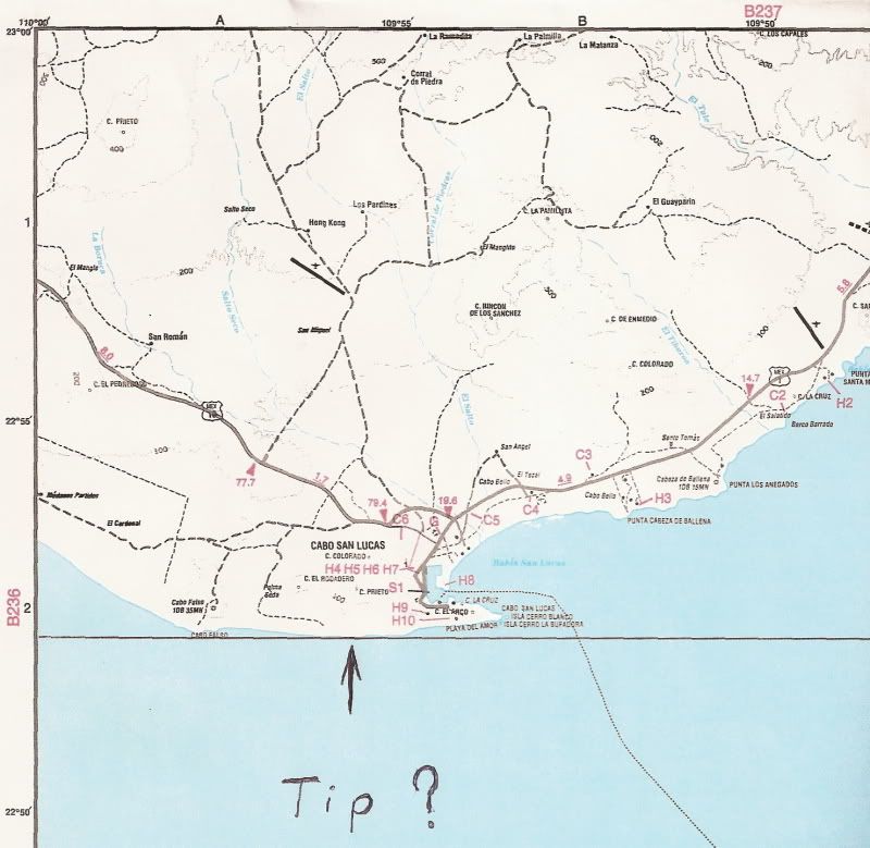
The map is Baja Topo Atlas, from government topos. I added an east/west line of latitude to see the place that is the most southern... the beach
between Cabo Falso and Cabo San Lucas. Cabo Falso, above which is the lighthouse is #2...
The rocks of 'Los Arcos' is surely the most dynamic looking of the three points... I think keeping it as the 'tip of Baja' would be best for photo
shots, etc!
|
|
|
Baja&Back
Senior Nomad
Posts: 549
Registered: 9-10-2004
Location: Vancouver, Canada / todo de Baja
Member Is Offline
Mood: Rarin' to go South!
|
|
David: your map is crooked! Too many Pacificos.
|
|
|
Barry A.
Select Nomad
Posts: 10007
Registered: 11-30-2003
Location: Redding, Northern CA
Member Is Offline
Mood: optimistic
|
|
| Quote: | Originally posted by Baja&Back
David: your map is crooked! Too many Pacificos. |
According to the Latitude lines (which show in David's picture), David has the map oriented correctly----also according to my "old" BAJA ATLAS which
is a duplicate of the one that David used. Of course, the Atlas may be wrong, I suppose.
Barry
|
|
|
Barry A.
Select Nomad
Posts: 10007
Registered: 11-30-2003
Location: Redding, Northern CA
Member Is Offline
Mood: optimistic
|
|
Just a note of interest---------the main AAA club map of Baja is oriented incorrectly, as you look at it, but when you check out the Latitude lines on
it you will realize this, and correct to account for it.
Barry
|
|
|
David K
Honored Nomad
Posts: 65591
Registered: 8-30-2002
Location: San Diego County
Member Is Offline
Mood: Have Baja Fever
|
|
| Quote: | Originally posted by Barry A.
Just a note of interest---------the main AAA club map of Baja is oriented incorrectly, as you look at it, but when you check out the Latitude lines on
it you will realize this, and correct to account for it.
Barry |
That's because Baja isn't a perfect north/ south peninsula, it goes southeast, so much that the southern half is in a different time zone... So, for
it to fit on rectangular map AAA or wall maps, it needs to be tilted or leaning.
As you can see the 'cape' at San Lucas points EAST, not south.
|
|
|
Barry A.
Select Nomad
Posts: 10007
Registered: 11-30-2003
Location: Redding, Northern CA
Member Is Offline
Mood: optimistic
|
|
I know, I know---------you are just trying to convince all of us that the peninsula leans "right", not "left"------obviously a political statement,
very rude and haughty of you, and obviously just can't be true because YOU said it. I bet you watch FOX NEWS, too!
OK, now attack me------------------
(sorry about this-------I just could not help myself)
Barry
|
|
|
JESSE
Ultra Nomad
Posts: 3370
Registered: 11-5-2002
Member Is Offline
|
|
So technically, the Arch is not on both sides, just on the Sea of Cortez one.
|
|
|
Cardon Man
Super Nomad
Posts: 1319
Registered: 8-28-2003
Location: Thetis Bank
Member Is Offline
Mood: !Al Chingaso!
|
|
Pacific or Gulf?
| Quote: | Originally posted by JESSE
So technically, the Arch is not on both sides, just on the Sea of Cortez one. |
I've often wondered about where the Pacific ends and the Cortez begins. Is it a line drawn from the arch to the mainland? On Wikipedia there is a map
that shows the Gulf of California beginning well "around the corner", around Cabo Pulmo or so. What up?
|
|
|
MrBillM
Platinum Nomad
Posts: 21656
Registered: 8-20-2003
Location: Out and About
Member Is Offline
Mood: It's a Zip-a-Dee-Doo-Dah Day
|
|
The True Tip ?
More importantly, where do you find the Best Tri-Tip in Baja ?
|
|
|
fdt
Ultra Nomad
Posts: 4059
Registered: 9-7-2003
Location: Tijuana, Baja California
Member Is Offline
Mood: Yeah, what if it all goes right
|
|
And lovers beach (Playa del Amor)? Does this mean it's gay?
A well informed Baja California traveler is a smart Baja California traveler!
|
|
|
Bajahowodd
Elite Nomad
Posts: 9274
Registered: 12-15-2008
Location: Disneyland Adjacent and anywhere in Baja
Member Is Offline
|
|
Despite David's map, why would anyone have put el faro where it is unless it was to signify something? For as long as I can remember, Cabo Falso was
considered to be the Southern-most point.
|
|
|
bajasuzie
Junior Nomad
Posts: 47
Registered: 8-19-2007
Location: San Jose del cabo
Member Is Offline
Mood:
|
|
Can any provide more info on whether the tip would then be Sea of Cortez or Pacific. Or is there such a thing as a mixture?
|
|
|
Bajahowodd
Elite Nomad
Posts: 9274
Registered: 12-15-2008
Location: Disneyland Adjacent and anywhere in Baja
Member Is Offline
|
|
I suppose an oceanographer would be of help here. What I do know from personal experience is that on the SOC side, the water does not warm
significantly until many miles NW of El Arco. I would guess that the actual body of water by name would be when it is no longer directly influenced by
the Pacific. Just a guess. Look forward to any help on this.
|
|
|
Barry A.
Select Nomad
Posts: 10007
Registered: 11-30-2003
Location: Redding, Northern CA
Member Is Offline
Mood: optimistic
|
|
Susie------I don't believe that it has ever been really defined----nor should it be, probably. Since technically the "Sea of Cortez" is an appendage
of the Pacific Ocean, the actual boundery is really moot, and up to personal interpretation--------at least that is the way I have always heard it
explained.
Barry
|
|
|
David K
Honored Nomad
Posts: 65591
Registered: 8-30-2002
Location: San Diego County
Member Is Offline
Mood: Have Baja Fever
|
|
| Quote: | Originally posted by Bajahowodd
Despite David's map, why would anyone have put el faro where it is unless it was to signify something? For as long as I can remember, Cabo Falso was
considered to be the Southern-most point. |
The map is Mexican government in origin, and correct... North is the top. What I did was draw that east/west line so it is easy to see the
SOUTHERNMOST 'tip' of Baja... and drew the arrow to point that out.
IMO:
As for the romantic cape (San Lucas) and the seperation of the gulf from the Pacific... taking a line and going straight east from the cape to the
mainland would be logical... However, as said above, the water isn't really typical of being a gulf vs. an ocean until one is north of the cape
region... where there are no ocean swell created waves. That would probably be where the coast faces more east instead of more south?
Do the people who live between San Jose del Cabo and Cabo San Lucas call the sea water in front of them the Gulf of California (Sea of Cortés) or the
Pacific Ocean?
Here is the McMahan wall map with Baja tilted NW to SE:

|
|
|
Bajahowodd
Elite Nomad
Posts: 9274
Registered: 12-15-2008
Location: Disneyland Adjacent and anywhere in Baja
Member Is Offline
|
|
Still doesn't explain why the lighthouse is where it is. btw, a friend and I visited the lighthouse many years ago. Unbeknownst to us, there was a
caretaker. We came upon him taking a bath in a tub that was outside, just below the lighthouse. He jumped up, grabbed a gun, and chased us wet and
naked. At least he didn't fire his weapon.
|
|
|
| Pages:
1
2
3 |