| Pages:
1
2
3
4
..
6 |
David K
Honored Nomad

Posts: 65595
Registered: 8-30-2002
Location: San Diego County
Member Is Offline
Mood: Have Baja Fever
|
|
Even with the best of maps, GPS, photos of the area... you cannot take the mystery out of Baja. Nothing compares with being there... Photos, maps,
trip reports only can HINT at what will be found when one goes there. The purpose of the trip details and maps is one of SAFETY. Know where you are in
relation to assistance, help, food, fuel... What roads go where... which saves the enviroment from unnecessary back tracking and fuel consumption...
The details may save a life or at least help to have a great trip.
|
|
|
Bajahowodd
Elite Nomad
Posts: 9274
Registered: 12-15-2008
Location: Disneyland Adjacent and anywhere in Baja
Member Is Offline
|
|
Just goes to show that our society, in general, will be more and more dependent on resources that didn't exist just a few years ago. The next
generation of Baja aficionados will have internet phones, GPS, and who knows what? Whatever happened to the idea of trying to disappear?
|
|
|
motoged
Elite Nomad
Posts: 6481
Registered: 7-31-2006
Location: Kamloops, BC
Member Is Offline
Mood: Gettin' Better
|
|
| Quote: | Originally posted by Bajahowodd
<snip....Whatever happened to the idea of trying to disappear? |
BH,
That is kind of my intention...to see some terrain new to me without disappearing for real....just temporarily removing myself from samsara 
I like my adventures to have some modicum of foresight, but expect the unexpected.
"Risk" is the "proximity to danger"....I try to manage it more than eliminate it....so Nomad comments about the area in question are helpful in that
management....
Don't believe everything you think....
|
|
|
woody with a view
PITA Nomad
Posts: 15940
Registered: 11-8-2004
Location: Looking at the Coronado Islands
Member Is Offline
Mood: Everchangin'
|
|
| Quote: | Originally posted by David K
Even with the best of maps, GPS, photos of the area... you cannot take the mystery out of Baja. Nothing compares with being there... Photos, maps,
trip reports only can HINT at what will be found when one goes there. The purpose of the trip details and maps is one of SAFETY. Know where you are in
relation to assistance, help, food, fuel... What roads go where... which saves the enviroment from unnecessary back tracking and fuel consumption...
The details may save a life or at least help to have a great trip. |
not everyone wants their hand held.
|
|
|
David K
Honored Nomad
Posts: 65595
Registered: 8-30-2002
Location: San Diego County
Member Is Offline
Mood: Have Baja Fever
|
|
I don't insist anyone look at what I post here. BUT...
Why have or go to a Baja forum if one doesn't have Baja stuff to read about?
I don't think most people come here just so they cannot read or see about places to go in Baja. This is supposed to be a place where friends/ fellow
Nomads exchange information and share... You know give a little back for all that you take...
|
|
|
DEVEAU
Nomad
Posts: 104
Registered: 11-29-2005
Member Is Offline
Mood: "WFO"
|
|
| Quote: | Originally posted by David K
Nice trip! Looks like the route to San Ignacio south of El Barril via Trinidad is back open... You may have used some of the Jesuit El Camino Real
between Trinidad and San Marta!
Hope you have photos to share!
Thank you! |
We failed on the photo mission, we have very few. It's hard to grasp the view with just a snapshot.
We were wondering if the "road" from San Marta to the coast was back from the time of the Missions? It pretty much followed the wash.
From Trinidad to El Barril was very doable on a bike, just a real long day, hard to follow in places.
Chase Trucks? ??
We don\'t need no stinking chase trucks!
|
|
|
Curt63
Super Nomad
Posts: 1171
Registered: 3-28-2009
Location: San Diego, Ca.
Member Is Offline
Mood: Fish tacos and Tecate
|
|
A long time ago (June 2006) St. Rosalillita had jug gas at the only abarrotes in town.
For some reason we just loved this picture. I'm not sure why. We even had a nickname for this lady...I can't seem to remember it.

Another bit of advice for fish camps. The one medium of exchange they cant refuse is lingerie. This stuff is not readily available down there and you
would be surprised how many lobster you get.
If they have gas, they will trade for it!
No worries
|
|
|
David K
Honored Nomad
Posts: 65595
Registered: 8-30-2002
Location: San Diego County
Member Is Offline
Mood: Have Baja Fever
|
|
Post counts have nothing at all to do with anything I do on Nomad... Wouldn't mind at all if Doug did away with the ranking system.
I enjoy reading about everyone's trips, where they went, what they saw... We all 'take' something from Nomad... that's what is here for... us Nomads!
Now, about the giving... some give a lot, some a little (reports, answers, info., photos)... some would like to post photos but haven't figured out
how... doesn't matter. Having a good Baja amigo spirit says more... No need to u2u secret messages... that is there for phone numbers or other
non-Internet stuff between friends.
Just what do you say to book authors/ map makers who have published that road along the Pacific coast? Do you really think you have some special right
to bad mouth anything that gets close to the Seven Sisters? I went by there in 2007 and have no interest in surfing. I had the AAA map and Baja
Almanac and the Lower Ca Guidebook to compare notes with what I found.
I really don't get what you are affraid of? So many fewer people are going to Baja because they are affraid or they are broke, than the years before
2009.
I have published the photos, maps and location of my favorite camp area (Shell Island) for years here. The place is just as beautiful and perfect as
it was when I first camped out there in 1978. The Cortez side gets a ton more vacation people than your foggy Pacific Sisters... What are you
protecting out there? Isn't the ocean big enough for another Nomad surfer to enjoy, too?
If you have an issue with opening the place up, take it up with the Mexican government who is building a very good road north from Santa Rosalillita.
Good roads will mess up a place, not road logs or maps.
|
|
|
woody with a view
PITA Nomad
Posts: 15940
Registered: 11-8-2004
Location: Looking at the Coronado Islands
Member Is Offline
Mood: Everchangin'
|
|
| Quote: | Originally posted by Curt63
A long time ago (June 2006) St. Rosalillita had jug gas at the only abarrotes in town.
For some reason we just loved this picture. I'm not sure why. We even had a nickname for this lady...I can't seem to remember it.
Another bit of advice for fish camps. The one medium of exchange they cant refuse is lingerie. This stuff is not readily available down there and you
would be surprised how many lobster you get.
If they have gas, they will trade for it! |
is that a jug of octane booster? there is a 10,000 gallon PEMEX tank at the marina now. the ? is, is there any gas in it? or is it for the boats who
use the escalera nautica?
edit: BTW, what is a crusty old fisherman gonna do with lingerie?????
and more important, why are you carrying it around with you????
[Edited on 12-2-2009 by woody in ob]
|
|
|
woody with a view
PITA Nomad
Posts: 15940
Registered: 11-8-2004
Location: Looking at the Coronado Islands
Member Is Offline
Mood: Everchangin'
|
|
like i said......
| Quote: |
you have no idea what i take! you can have the last word now... or continue shining the spotlight on yourself, i've been down this road before....
|
you just don't get it! i understand!!!
|
|
|
DianaT
Select Nomad
Posts: 10020
Registered: 12-17-2004
Member Is Offline
|
|
| Quote: | Originally posted by woody in ob
is that a jug of octane booster? there is a 10,000 gallon PEMEX tank at the marina now. the ? is, is there any gas in it? or is it for the boats who
use the escalera nautica? |
Build it and they will come, yes build it and they will come. If there is gas in that tank, I hope it is a strong tank that will protect the gas for
a VERY long time
|
|
|
mtgoat666
Platinum Nomad
Posts: 21174
Registered: 9-16-2006
Location: San Diego
Member Is Offline
Mood: Hot n spicy
|
|
| Quote: | Originally posted by woody in ob
| Quote: | Originally posted by David K
I don't insist anyone look at what I post here. BUT...
Why have or go to a Baja forum if one doesn't have Baja stuff to read about?
I don't think most people come here just so they cannot read or see about places to go in Baja. This is supposed to be a place where friends/ fellow
Nomads exchange information and share... You know give a little back for all that you take... |
you have no idea what i take!
you can have the last word now... or continue shining the spotlight on yourself, i've been down this road before....
give the info u2u sometime. not all Nomads NEED to see their
post count rise. try viagra..... |
i hate to admit this, but in this case i partly agree with DK. publishing the main travel roads is helpful and what armchair travelers like DK have
done since dawn of time.
i do agree with Woody that DK should not publish locations/info on surf breaks, archaeolgical sites and other "sensitive" sites,... let people figure
it out for themselves, and hopefully slow the rush to crowding.
|
|
|
woody with a view
PITA Nomad
Posts: 15940
Registered: 11-8-2004
Location: Looking at the Coronado Islands
Member Is Offline
Mood: Everchangin'
|
|
like i said goat, send a u2u once in awhile. hasn't this been beat to death? there is a sensitive area (does it really matter what the subject matter
is?) that some folks use regularly. our hero, dk never uses it but is ALWAYS shining the light on his narcissitic (sp?) ego just to push other folks
buttons. he knows before he posts his map to those "ugly fish camps" as he called them. send a u2u, defer once in awhile. let someone else take the
discussion private. i'm not into censoring dk or anyone. so far my u2u's are 4-0 against, you guessed it, dk.
i'm not trying to claim local guy status. i'm just trying to beat a dead horse. someday, on a single track - Neptune willing!!!!
|
|
|
Skipjack Joe
Elite Nomad
Posts: 8092
Registered: 7-12-2004
Location: Bahia Asuncion
Member Is Offline
|
|
| Quote: | Originally posted by Curt63
Another bit of advice for fish camps. The one medium of exchange they cant refuse is lingerie. This stuff is not readily available down there and you
would be surprised how many lobster you get.
|
How do you know what size to get. 
| Quote: | Originally posted by woody in ob
[DK]...just to push other folks buttons.
|
Absolutely. He gets off on getting people agitated. This entire thread could have been handled differently. You have to wonder: where's the
satisfaction.
|
|
|
Crusoe
Senior Nomad
Posts: 731
Registered: 10-14-2006
Member Is Offline
|
|
All this "SECRET STUFF" is just more amusing B.S..... This part of Baja is rugged and remote.....Saying that, we have to realize it has been traversed
by hundreds of people over the last 40 years or so. Desert Vagabonds, surfers, fisherman, miners, explorerers, crminals on the lamb and the likes of
who knows who. The area is no big secret.The surfbreaks all are available on the internet and guidebooks. Google is another whole story. People that
want an adventure and are challanged in this quest will find lots to see if they go slow and pay attention to their surroundings. It is very doable.
Not to worry that this area will ever become overrun or over used in our lifetime. ++C++
|
|
|
bajaandy
Senior Nomad
Posts: 769
Registered: 2-7-2004
Location: North County
Member Is Offline
Mood: Adventurous
|
|
Now now woody... lets not forget that not all that long ago you were the one asking the questions just like the OP. (True, we conversed via U2U more
than on the board, but still...) And as far as I'm concerned, DK or anybody else can post all the damn maps and waypoints they want. Who gives a rats
a$$? You can never, NEVER be prepared for what you're going to get into down there whether you've studied every inch of the map or not. It's ALWAYS
going to be an adventure once you set your tires on that road.
I don't know this for sure, but my guess is that the old timers that used to follow hand drawn maps probably got a little miffed when maps and books
came out telling "the masses" all about the places they used to get to only by memory. What I'm trying to say is that change is constant. There is
always going to be someone improving the map. We live in a technological world. Most folks roll with it, some don't, some check out of it. But it
ain't goin' away anytime in my lifetime. You can have all the technology money can buy, but it still won't take away the charm of Baja... especially
when the batteries die, the clouds won't let you connect with the satellite, your tire goes flat and you've already used the spare, the catalytic
converter fouls, the mass air flow sensor clogs, you thought you had more gas than you really do, you play the music too long and kill the truck
battery, but the surf is firing and you're in Baja, so it's all good.
So motoged, get out there on that road and have some fun. Get lost on the wrong road and see where it goes. Take your time and look around closely...
there are some AMAZING things to be seen along that piece of dirt track. Enjoy your time and write it all down so you can look back in ten years and
read it and remember it. And if ya feel like it, share it.
It's all good.
subvert the dominant paradigm
"If you travel with a man, you must either fall out with him or make him your good friend."
JBL Noel
|
|
|
mojo_norte
Senior Nomad
Posts: 725
Registered: 2-14-2006
Member Is Offline
|
|
| Quote: | Originally posted by bajaandy
Now now woody... lets not forget that not all that long ago you were the one asking the questions just like the OP. (True, we conversed via U2U more
than on the board, but still...) And as far as I'm concerned, DK or anybody else can post all the damn maps and waypoints they want. Who gives a rats
a$$? You can never, NEVER be prepared for what you're going to get into down there whether you've studied every inch of the map or not. It's ALWAYS
going to be an adventure once you set your tires on that road.
I don't know this for sure, but my guess is that the old timers that used to follow hand drawn maps probably got a little miffed when maps and books
came out telling "the masses" all about the places they used to get to only by memory. What I'm trying to say is that change is constant. There is
always going to be someone improving the map. We live in a technological world. Most folks roll with it, some don't, some check out of it. But it
ain't goin' away anytime in my lifetime. You can have all the technology money can buy, but it still won't take away the charm of Baja... especially
when the batteries die, the clouds won't let you connect with the satellite, your tire goes flat and you've already used the spare, the catalytic
converter fouls, the mass air flow sensor clogs, you thought you had more gas than you really do, you play the music too long and kill the truck
battery, but the surf is firing and you're in Baja, so it's all good.
So motoged, get out there on that road and have some fun. Get lost on the wrong road and see where it goes. Take your time and look around closely...
there are some AMAZING things to be seen along that piece of dirt track. Enjoy your time and write it all down so you can look back in ten years and
read it and remember it. And if ya feel like it, share it.
It's all good. |
Right on!!
|
|
|
David K
Honored Nomad
Posts: 65595
Registered: 8-30-2002
Location: San Diego County
Member Is Offline
Mood: Have Baja Fever
|
|
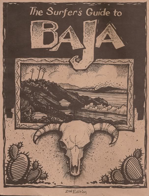
Crusoe and Andy get it, Skipjack doesn't... Is being friendly to people you have met, and have not met, really that foreign to some of you?
Anyway, Woody... take your anger out with the guy who wrote this book... becaue it is a guide to all the surf points in your sacred 7 sisters and the
rest of Pacific Baja... marketed to SURFERS! 2nd edition, 2002. My road log was for off-roaders and because of the u2us you sent to me when I
returned, I made the area less than appealing in my trip report and web page... Because you asked me to be negative about the area, I called thes fish
camps ugly, and the area unattractive, etc. I never posted GPS waypoints of any surf spots (if I even knew where they were) yet you make it sound as
if I did. I try and be nice and considerate to your issues, and still you act the way you do... Oh well...
Now, if you need the contact details on this guidebook... it is for sale at Discover Baja Travel Club.
|
|
|
TMW
Select Nomad
Posts: 10659
Registered: 9-1-2003
Location: Bakersfield, CA
Member Is Offline
|
|
| Quote: | Originally posted by motoged
You guys are why I like BN  
I will contact some of you by U2U for info....as for this thread, my main questions are:
1) First week of February...what are temp and fog
conditions like?
I am thinking it is cold and foggy in morning and late
afternoon???
2) I am wondering if fishcamps have gas.... I have a 5 gal tank on bike and
3) I do not plan on camping and want to do the route in one day...will not do the northern section closest to El Rosario, but will enter boulder
fields 5-8 miles north of Catavina and head towards Arroyo El Bocano and head south from there...
Trip planning is so much fun... |
We've done the Catavina to Santa Rosalillita and out to the hwy on XR500 bikes with the stock 3.4 gallon tanks. I would suggest you carry an extra
gallon or two to be safe. The fish camps may have extra gas to sell but I would only count on them in an emergency.
|
|
|
mojo_norte
Senior Nomad
Posts: 725
Registered: 2-14-2006
Member Is Offline
|
|
| Quote: | Originally posted by David K[/
If you have an issue with opening the place up, take it up with the Mexican government who is building a very good road north from Santa Rosalillita.
Good roads will mess up a place, not road logs or maps. |
Details on this new road north from Santa Rosalillita?!
|
|
|
| Pages:
1
2
3
4
..
6 |


