| Pages:
1
2 |
elfbrewery
Nomad

Posts: 350
Registered: 12-25-2006
Member Is Offline
|
|
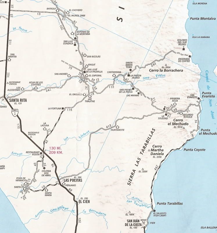
San Evaristo from Hwy 1
Does anyone know how to get from Hwy 1 to San Evaristo via Mision San Luis Gonzaga? Is it worth the effort to go this way?
|
|
|
David K
Honored Nomad
Posts: 65595
Registered: 8-30-2002
Location: San Diego County
Member Is Offline
Mood: Have Baja Fever
|
|
You need the Baja Almanac! It has pretty much most all the dirt roads in the peninsula.
Just be sure to correct the latitude numbers on Map 18 if you are using it with a GPS! Available in San Diego at Discover Baja Travel Club. http://baja-almanac.com
I haven't been to that mission (yet)... here are some notes on the road:
Leave Hwy. 1 about 10 miles south of Cd. Constitucion on the straight graded road to S. L. Gonzaga via the Presa Ihuagil (dam) road. Go 13 miles east,
then take the right fork for 11 miles to the mission village. The AAA guide says there is a camping area, small store and even gs from barrels
available there.
From San Luis Gonzaga to San Evaristo, best to have the Almanac to double check the roads to use... a GPS with the topo maps installed would be killer
to have in that area! You are also inthe area of the two Dolores mission sites (Los Dolores Apate near the coast and the last site at La Pasion (near
Rancho La Presa at La Capilla). See Jack Swords' photos of La Presa at http://vivabaja.com/swords .
Search Nomad (top left of the page) for all posts containing San Evaristo and maybe La Soledad (along the road above San Evaristo)?
[Edited on 12-9-2009 by David K]
|
|
|
TMW
Select Nomad
Posts: 10659
Registered: 9-1-2003
Location: Bakersfield, CA
Member Is Offline
|
|
Always remember the people you meet along the way are always helpful. We came out from Evaristo to hwy 1 at Las Pocitas a couple of years ago, when in
from La Paz, and we met a couple of cowboys on horseback. We gave them a cold one and they let us set on their horses for pictures.
|
|
|
Jack Swords
Super Nomad
Posts: 1097
Registered: 8-30-2002
Location: Nipomo, CA/La Paz, BCS
Member Is Offline
|
|
David's advice is righton. There is a mission sign just south of Constitucion and you turn east and the road to the mission is evident. Going east
to Evaristo you will encounter many branches of roads with noone to ask directions. The atlas will help. From the top down to Evaristo is sometimes
a challenge. The race Dos Mares uses it. Wonderful area, lots of water, great people. It's like stepping back 200 years. We do it from Pocitas on
the highway, but have done the Gonzaga mission too. We camp midway as it can be a long trip. The road from Evaristo to San Juan de la Costa (La Paz)
is maddening due to permanentes (washboard). Fast/slow it is crazy. Suggest asking along the way if the road is passable by a gringo after Segunda
Bosque. You do have 4WD?
|
|
|
monoloco
Elite Nomad
Posts: 6667
Registered: 7-13-2009
Location: Pescadero BCS
Member Is Offline
|
|
The road from El Bosque to the coast can be pretty bad, you will want to know the condition before you try the Las Positas route. Usually the San Juan
de La Costa route is maintained for the fish buyers' trucks who travel to La Paz and back a few times a week.
|
|
|
David K
Honored Nomad
Posts: 65595
Registered: 8-30-2002
Location: San Diego County
Member Is Offline
Mood: Have Baja Fever
|
|
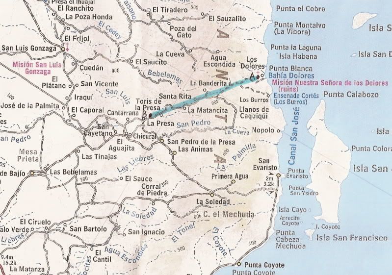
MAPS TO ASSIST
Here is a view of the area... the 2007 AAA map and 2003 Baja topo (blue hi-lightiner line connects the two Dolores mission locations (see my Baja
Missions web site for photos at both sites)...

Zoom in for mileage details...
Both Dolores mission sites (Apate, and Chilla at La Pasion)
|
|
|
elfbrewery
Nomad
Posts: 350
Registered: 12-25-2006
Member Is Offline
|
|
Thanks for the info
Yes, I am looking forward to devouring the new "Almanac" when I receive my copy in the new year. And, yes, we do have 4wd and will be travelling with
others. Just don't want my desire to travel new roads (for me) to bug my fellow travellers.
Are the ruined missions worth the visit?
Thanks for your help.
|
|
|
monoloco
Elite Nomad
Posts: 6667
Registered: 7-13-2009
Location: Pescadero BCS
Member Is Offline
|
|
There is no drivable road to Los Dolores.
|
|
|
David K
Honored Nomad
Posts: 65595
Registered: 8-30-2002
Location: San Diego County
Member Is Offline
Mood: Have Baja Fever
|
|
Depends what is interesting to you... this part of California history is vanishing in our lifetime... The Mexican historic preservation lacks funds to
properly preserve all the old California missions... Dolores and La Pasion have had no restoration or protectionthat I am aware of... see them before
they are gone forever!
Dolores del Sur (both sites), below Guadalupe del Sur on this page: http://www.vivabaja.com/missions1/page5.html
San Luis Gonzaga, at the bottom of this page: http://www.vivabaja.com/missions1/page6.html
|
|
|
David K
Honored Nomad
Posts: 65595
Registered: 8-30-2002
Location: San Diego County
Member Is Offline
Mood: Have Baja Fever
|
|
| Quote: | Originally posted by monoloco
There is no drivable road to Los Dolores. |
That is correct, despite what the Baja Almanac shows, that is a mission trail to Los Dolores near the coast, not an automobile or Jeep road!
La Pasion is on the road, however... as is San Luis Gonzaga.
You can see Dolores if you hike from the Los Burros/Ensenada de Cortez road to the ridge of the canyon (see Jack Swords photo)
|
|
|
rob
Senior Nomad
Posts: 509
Registered: 10-19-2004
Location: Pacific Coast, BCS
Member Is Offline
|
|
SAN EVARISTO/LOS BURROS
What Dave says . .. the road from La Soledad down into San Evaristo is totally beautiful - we camped at the top of the pass (photo).
At San Luis Gonzaga my old Lance camper did its usual party trick of tearing an overhead line down (was being rigged for the big Saturday dance and
VERY low over the road) - it was the same thing I was arrested for in Guerrero Negro where Shari saved us.

|
|
|
rob
Senior Nomad
Posts: 509
Registered: 10-19-2004
Location: Pacific Coast, BCS
Member Is Offline
|
|
LOS BURROS
On Dave's third map you will see a trail headed down to Los Burros (See photo). Nor for the faint of heart but perfectly drivable. Super fisherfolk
who made us feel right at home. I drove (boat) up there from San Evaristo, just around the corner.
Los Dolores is actually a ranch where the welcome was lukewarm. When last visited (2003) it was being foreclosed by a Texas bank, no idea of current
status.

|
|
|
rob
Senior Nomad
Posts: 509
Registered: 10-19-2004
Location: Pacific Coast, BCS
Member Is Offline
|
|
LOS BURROS
On Dave's third map you will see a trail headed down to Los Burros (See photo). Nor for the faint of heart but perfectly drivable. Super fisherfolk
who made us feel right at home. I drove (boat) up there from San Evaristo, just around the corner.
Los Dolores is actually a ranch where the welcome was lukewarm. When last visited (2003) it was being foreclosed by a Texas bank, no idea of current
status.
[Edited on 12-10-2009 by rob]

|
|
|
monoloco
Elite Nomad
Posts: 6667
Registered: 7-13-2009
Location: Pescadero BCS
Member Is Offline
|
|
Rob, Did you take your Lance camper into Los Burros?
|
|
|
wilderone
Ultra Nomad
Posts: 3915
Registered: 2-9-2004
Member Is Offline
|
|
"The road from Evaristo to San Juan de la Costa (La Paz) is maddening due to permanentes (washboard). Fast/slow it is crazy. Suggest asking along the
way if the road is passable by a gringo after Segunda Bosque."
Si - but accessible by kayak/boat. Hire someone to panga you along the coast. What an adventure! (Can "panga" be a verb?)
|
|
|
rob
Senior Nomad
Posts: 509
Registered: 10-19-2004
Location: Pacific Coast, BCS
Member Is Offline
|
|
Hi monoloco - I did indeed take my Lance 8' down to Los Burros (and to Batopilas in Barranca del Cobre - but that's another story!). It's not a great
Baja choice - finally sold it and bought a Northstar pop top.
Highly recommended.
|
|
|
monoloco
Elite Nomad
Posts: 6667
Registered: 7-13-2009
Location: Pescadero BCS
Member Is Offline
|
|
| Quote: | Originally posted by rob
Hi monoloco - I did indeed take my Lance 8' down to Los Burros (and to Batopilas in Barranca del Cobre - but that's another story!). It's not a great
Baja choice - finally sold it and bought a Northstar pop top.
Highly recommended. |
Nice photos. That is a great section of coastline from Evaristo to Los Burros. Great
people, great fishing, islands, it's pretty much got it all except for great roads, but of course that's why it is still nice there. I can't imagine
going into Los Burros with a cabover camper, it takes me 2 hours to go the 15k into San Nicolas with mine and that's a relatively good road compared
to Los Burros.
|
|
|
rob
Senior Nomad
Posts: 509
Registered: 10-19-2004
Location: Pacific Coast, BCS
Member Is Offline
|
|
Campers and roads
I couldn't resist it - the off-topic police will get me, but that's life!
Here is a shot of a road that makes the Los Burros hairpins look rather tame - it is the road to Batopilas in Barranca del Cobre. 6,700 almost
vertical feet of hairpins - and single lane at that! This is why I don't think the Lance is a good exploring camper - even for my F350 diesel, it was
just too heavy.

|
|
|
monoloco
Elite Nomad
Posts: 6667
Registered: 7-13-2009
Location: Pescadero BCS
Member Is Offline
|
|
Yikes!
|
|
|
elfbrewery
Nomad
Posts: 350
Registered: 12-25-2006
Member Is Offline
|
|
Can you give me an idea of how many hours of driving it would take to get from Constitucion to La Paz via the San Luis Gonzaga - San Evaristo - San
Juan de la Costa route? This looks like a great camping/kayaking adventure.
Thanks!
|
|
|
| Pages:
1
2 |


