| Pages:
1
2 |
dizzyspots
Senior Nomad

Posts: 603
Registered: 9-22-2008
Location: Mescal AZ
Member Is Offline
Mood: rather be on the beach at Gonzaga
|
|
where is km 0?
silly, rookie question, but where do you start measuring the KM's as you head south from San Felipe towards Puertecitos and Gonzaga Bay?
Thanks
|
|
|
bajalou
Ultra Nomad
Posts: 4459
Registered: 3-11-2004
Location: South of the broder
Member Is Offline
|
|
At the left turn away from the airport road, just before La Hacienda.
No Bad Days
\"Never argue with an idiot. People watching may not be able to tell the difference\"
\"The trouble with doing nothing is - how do I know when I\'m done?\"
Nomad Baja Interactive map
And in the San Felipe area - check out Valle Chico area |
|
|
David K
Honored Nomad
Posts: 65595
Registered: 8-30-2002
Location: San Diego County
Member Is Offline
Mood: Have Baja Fever
|
|
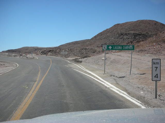
The brand new section south of Puertecitos is using a different 0 point... I wish I took some photos of them...
Here is the Km. sign at the Puertecitos exit:
|
|
|
woody with a view
PITA Nomad
Posts: 15940
Registered: 11-8-2004
Location: Looking at the Coronado Islands
Member Is Offline
Mood: Everchangin'
|
|
km zero is wherever you are at the moment!
and upstream is to the north when facing the sea. downstream is south.....
|
|
|
DavidE
Ultra Nomad
Posts: 3814
Registered: 12-1-2003
Location: Baja California México
Member Is Offline
Mood: 'At home we demand facts and get them. In Mexico one subsists on rumor and never demands anything.' Charles Flandrau,
|
|
"Puertecitos Use Left Lane"
Next it'll be "Alfonsina's Overflow Parking Use Ramp 6"
Too civilized for me; they're chasing me out of Mexico and down to Guatemala. Maybe there there won't be botts dotts and @#$%&^*&! texting!
|
|
|
k-rico
Super Nomad
Posts: 2079
Registered: 7-10-2008
Location: Playas de Tijuana
Member Is Offline
|
|
| Quote: | Originally posted by dizzyspots
silly, rookie question, but where do you start measuring the KM's as you head south from San Felipe towards Puertecitos and Gonzaga Bay?
Thanks |
Great rookie question!!! There's a bunch of them on the peninsula. I think the first one, on the west side, is Tijuana City Hall. Where's the next?
Ensenada? And after, and after......
[Edited on 10-3-2010 by k-rico]
|
|
|
mulegemichael
Super Nomad
Posts: 2310
Registered: 12-24-2007
Location: sequim,wa. and mulege
Member Is Offline
Mood: up on step
|
|
i thought it was at guererro negro???...no?...i know it's where we start, at least mentally, our first kilometer
dyslexia is never having to say you\'re yrros.
|
|
|
bajalou
Ultra Nomad
Posts: 4459
Registered: 3-11-2004
Location: South of the broder
Member Is Offline
|
|
David - I think they are using the same spot - 74 K = 45.98 miles which looks about right to me.
No Bad Days
\"Never argue with an idiot. People watching may not be able to tell the difference\"
\"The trouble with doing nothing is - how do I know when I\'m done?\"
Nomad Baja Interactive map
And in the San Felipe area - check out Valle Chico area |
|
|
bajajudy
Elite Nomad
Posts: 6886
Registered: 10-4-2004
Location: San Jose del Cabo,BCS
Member Is Offline
|
|
There is also one in San Lucas
|
|
|
David K
Honored Nomad
Posts: 65595
Registered: 8-30-2002
Location: San Diego County
Member Is Offline
Mood: Have Baja Fever
|
|
| Quote: | Originally posted by bajalou
David - I think they are using the same spot - 74 K = 45.98 miles which looks about right to me. |
Yes Lou... that one is correct from the 0 point on the Airport road.. I am talking about the new road SOUTH of Puertecitos... they have km. markers
that seem to be from Mexicali... I didn't write them down.. but it was 200 something (I think)...
|
|
|
David K
Honored Nomad
Posts: 65595
Registered: 8-30-2002
Location: San Diego County
Member Is Offline
Mood: Have Baja Fever
|
|
| Quote: | Originally posted by mulegemichael
i thought it was at guererro negro???...no?...i know it's where we start, at least mentally, our first kilometer |
There are many Km. 0s in Baja:
Tijuana, Ensenada, San Quintin (where the newest part of the road was added in 1973 and the highway gets skinnier),
The L.A. Bay Hwy. Jcn. (formerly called Parador Punta Prieta), the State Border (Eagle Monument) near Guerrero Negro, Santa Rosalia, Loreto, Cd.
Insurgentes, La Paz, Cabo San Lucas.
In the state of Baja California they go from north to south. In the state of Baja California Sur they go from south to north.
So, as you drive south the number get bigger as you drive along south from each Km. 0 point.
As you cross into Baja Sur the numbers get smaller as you drive south to each Km. 0 point!
|
|
|
bajalou
Ultra Nomad
Posts: 4459
Registered: 3-11-2004
Location: South of the broder
Member Is Offline
|
|
| Quote: | Originally posted by David K
| Quote: | Originally posted by bajalou
David - I think they are using the same spot - 74 K = 45.98 miles which looks about right to me. |
Yes Lou... that one is correct from the 0 point on the Airport road.. I am talking about the new road SOUTH of Puertecitos... they have km. markers
that seem to be from Mexicali... I didn't write them down.. but it was 200 something (I think)... |
I guess I would expect some different counting on the new road, but San Felipe is about K200 from Mexicali on Hghy 5.
No Bad Days
\"Never argue with an idiot. People watching may not be able to tell the difference\"
\"The trouble with doing nothing is - how do I know when I\'m done?\"
Nomad Baja Interactive map
And in the San Felipe area - check out Valle Chico area |
|
|
David K
Honored Nomad
Posts: 65595
Registered: 8-30-2002
Location: San Diego County
Member Is Offline
Mood: Have Baja Fever
|
|
The rumor is the NEW Highway 5 will not use the current paved road south of San Felipe... that was engineered so poorly with all those steep vados. It
will stay inland like the old Puertecitos road, as it is more direct and they know it will be a busy route for trucks and busses... Perhaps from San
Felipe the 200+ km markers will continue, and they already figured the distance for the new alignment?
|
|
|
mcfez
Elite Nomad
Posts: 8678
Registered: 12-2-2009
Location: aka BN yankeeirishman
Member Is Offline
|
|
So you think the road will be out west of San Felipe....in the area of the transmission lines?
Old people are like the old cars, made of some tough stuff. May show a little rust, but good as gold on the inside.
|
|
|
David K
Honored Nomad
Posts: 65595
Registered: 8-30-2002
Location: San Diego County
Member Is Offline
Mood: Have Baja Fever
|
|
| Quote: | Originally posted by mcfez
So you think the road will be out west of San Felipe....in the area of the transmission lines? |
South of San Felipe... the current paved road goes southeast then south, parallel to the coast.
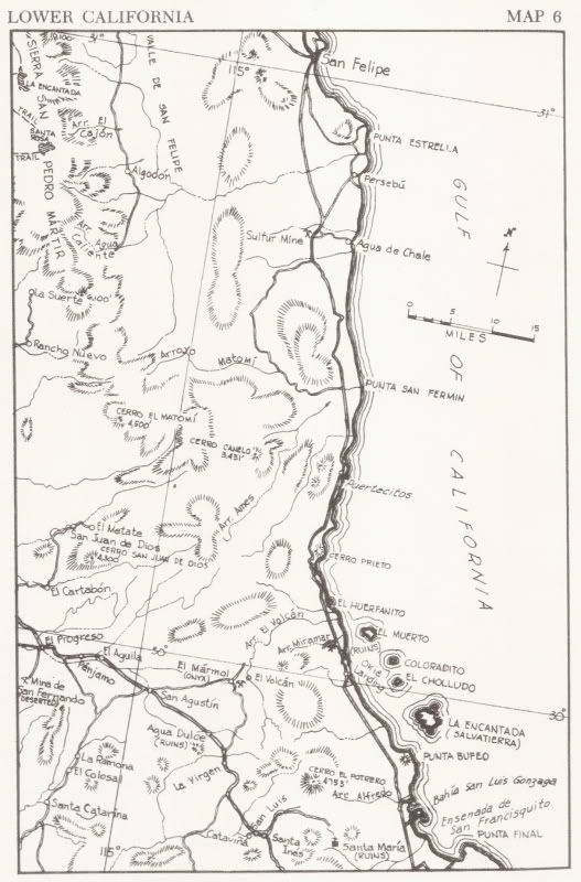
The old Puertecitos road was first built to the sulfur mine back around WWII to Korean War days or there-abouts (sulfur is needed for gunpowder).
Arturo Grosso built the first road north from his Rancho Laguna Chapala in the mid 1950's and took it right to the sulfur mine to complete a road to
San Felipe from the trans-peninsular road at his ranch... thus winning a financial prize offered by the government. There was no 'Puertecitos' until
later in the 1950's... same thing with the campos at Gonzaga Bay... only reached by the sea before roads were built.
Here is 1962 map...
[Edited on 10-4-2010 by David K]
|
|
|
TMW
Select Nomad
Posts: 10659
Registered: 9-1-2003
Location: Bakersfield, CA
Member Is Offline
|
|
When I was there in July of 09 I took a pix of KM282 past Puertecitos and it was about 8 K past the sign DK shows above. So I think they are
referencing to Mexicali as 0KM once you get to Puertecitos and San Felipe up to the town. By 2020 it will be corrected.
|
|
|
David K
Honored Nomad
Posts: 65595
Registered: 8-30-2002
Location: San Diego County
Member Is Offline
Mood: Have Baja Fever
|
|
| Quote: | Originally posted by TW
When I was there in July of 09 I took a pix of KM282 past Puertecitos and it was about 8 K past the sign DK shows above. So I think they are
referencing to Mexicali as 0KM once you get to Puertecitos and San Felipe up to the town. By 2020 it will be corrected. |
Thanks TW... Km. 0 at Mexicali is at the split of Hwy. 5 and Hwy. 2 (5 miles from the border, southbound).
San Felipe is 120 more miles south (192 kms.)... Now, Km. 0 where the current paved Puertecitos road begins (at the airport road) is 6.3 miles from
the traffic circle in San Felipe (10 km.)
192 km. + 10 km. = 202 km. (125 mi.)
Let's add that 74 km. (46 mi.) from the km. sign at the Puertecitos exit... = 276 km. (171 mi.)
You noted a Km. 282 sign...
282 - 276 = 6 km. (3.6 miles) This is close to your 8 km. figure.
I bet that is what they are doing? Perhaps they have the distance on the proposed new Hwy. 5 alignment figured out... It would be a bit shorter than
the current route that runs out past Punta Estrella... maybe 6 kms. shorter (subtract 6 km. from the 276 km. figure for Puertecitos = 270 km.)
Your Km. 282 - my estimate of 270 via the sulfur mine = 12 km., a bit over your 8 km. figure, but close.
|
|
|
durrelllrobert
Elite Nomad
Posts: 7393
Registered: 11-22-2007
Location: Punta Banda BC
Member Is Offline
Mood: thriving in Baja
|
|
| Quote: | Originally posted by David K
Thanks TW... Km. 0 at Mexicali is at the split of Hwy. 5 and Hwy. 2 (5 miles from the border, southbound).
San Felipe is 120 more miles south (192 kms.)... Now, Km. 0 where the current paved Puertecitos road begins (at the airport road) is 6.3 miles from
the traffic circle in San Felipe (10 km.)
192 km. + 10 km. = 202 km. (125 mi.)
Let's add that 74 km. (46 mi.) from the km. sign at the Puertecitos exit... = 276 km. (171 mi.)
You noted a Km. 282 sign...
282 - 276 = 6 km. (3.6 miles) This is close to your 8 km. figure.
I bet that is what they are doing? Perhaps they have the distance on the proposed new Hwy. 5 alignment figured out... It would be a bit shorter than
the current route that runs out past Punta Estrella... maybe 6 kms. shorter (subtract 6 km. from the 276 km. figure for Puertecitos = 270 km.)
Your Km. 282 - my estimate of 270 via the sulfur mine = 12 km., a bit over your 8 km. figure, but close. |
THANKS to our resident math major 
Bob Durrell
|
|
|
dizzyspots
Senior Nomad
Posts: 603
Registered: 9-22-2008
Location: Mescal AZ
Member Is Offline
Mood: rather be on the beach at Gonzaga
|
|
OK so if a fellow Nomad says they live at KM43...
I would start counting klik's where?
|
|
|
bajalou
Ultra Nomad
Posts: 4459
Registered: 3-11-2004
Location: South of the broder
Member Is Offline
|
|
| Quote: | Originally posted by bajalou
At the left turn away from the airport road, just before La Hacienda. |
No Bad Days
\"Never argue with an idiot. People watching may not be able to tell the difference\"
\"The trouble with doing nothing is - how do I know when I\'m done?\"
Nomad Baja Interactive map
And in the San Felipe area - check out Valle Chico area |
|
|
| Pages:
1
2 |


