| Pages:
1
2 |
chrisx
Banned
Posts: 173
Registered: 12-17-2009
Member Is Offline
Mood: baj nomad is broken
|
|
¿road?
Is there a road or trail from Coco´s Corner to Bola road? Or, is there a way from San Felipe to Bola that bypasses M1?
Bola/El arco to San Ignacio, same question? Bypasses M1?
|
|
|
David K
Honored Nomad

Posts: 65591
Registered: 8-30-2002
Location: San Diego County
Member Is Offline
Mood: Have Baja Fever
|
|
| Quote: | Originally posted by chrisx
Is there a road or trail from Coco´s Corner to Bola road? Or, is there a way from San Felipe to Bola that bypasses M1?
Bola/El arco to San Ignacio, same question? Bypasses M1? |
Yes, but it comes within a couple hundred feet of Mex. 1 in one place (El Crucero).
It is possible thank to the Baja 1000 that had a road made that parallels Hwy. 1 from El Crucero (after coming out of Calamajue Canyon) to the old
L.A. Bay road. You will need to ride the pavement for about half the distance or a bit more into L.A. Bay from the old L.A. Bay road where it joins
the new paved road.
You can see all this on Google Earth.
The second part of your question... You will need to be on Hwy 1 coming into San Ignacio from a point south of Vizcaino where the original main Baja
road meets Hwy. 1. The rest of the old main Baja road has been planted and built over by new farms in a few places, so using more of it may not be
easy.
See my posts of the Old Baja road I did recently with Google images.
[Edited on 1-5-2011 by David K]
|
|
|
bajabound2005
Ultra Nomad
Posts: 2762
Registered: 10-15-2005
Location: Punta Banda, BCN
Member Is Offline
Mood: words cannot describe...
|
|
chris: you might be interested in this. I'm doing it!
www.rosendaadventurerace.com
Kathleen
Friends don't let friends drink white zinfandel.
|
|
|
motoged
Elite Nomad
Posts: 6481
Registered: 7-31-2006
Location: Kamloops, BC
Member Is Offline
Mood: Gettin' Better
|
|
Chris,
What maps are you using for your trip planning?
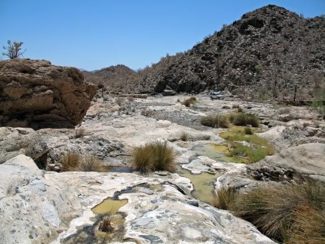
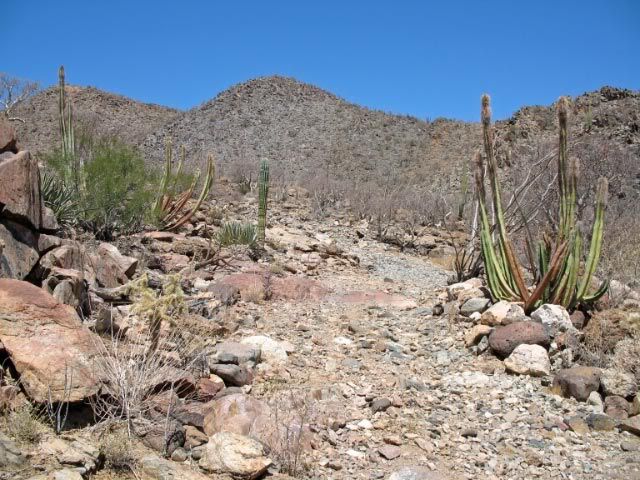
Southeast of Coco's is a lovely stretch known as the Calamujue Canyon wash....it is scenic, offers some water for cooling off in the heat, and is
well-traveled enough that it is easy to find 
The road from there takes you to El Crucero and the road David described to the BoLA road is also well traveled and scenic.
You will undoubtedly not come across any fat girls in Hondas on either road...it is a section you will be bound to remember for years to come as a
great ride...
Don't believe everything you think....
|
|
|
bent-rim
Nomad
Posts: 294
Registered: 7-31-2007
Location: Marin County
Member Is Offline
Mood: Living la vida mota
|
|
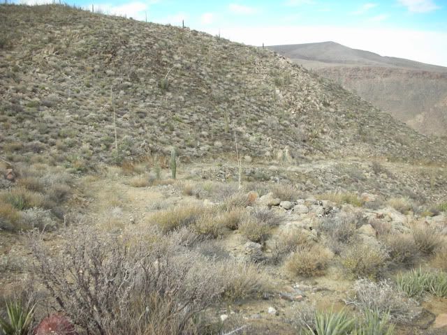
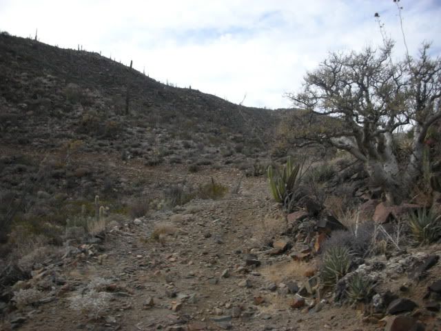
Head east out of Coco's and you'll come to right turn leading up a hill and that road will lead you to Calamajue Canyon. It is one of the most scenic
places in Baja and it has water to test out your filter with. It will be an unforgetable expereience. El Crucero can be bypassed and you'll come out
about 4-5 miles from LA Bay. I've done it on a dirt bike with some riding buddies. Check out Goggle Earth. You can also stay off road at El Crucero
and come out the road to BOLA about 35 miles from town. Lots of whoops in that section.
[Edited on 1-5-2011 by bent-rim]
[Edited on 1-6-2011 by bent-rim]
|
|
|
tripledigitken
Ultra Nomad
Posts: 4848
Registered: 9-27-2006
Member Is Offline
|
|
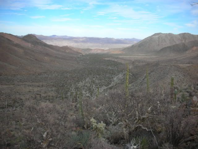
Calamujue Canyon wash
I agree a very scenic section of road.
Ken

Not too far from where this pic was taken there was a water crossing about 1' deep. (Mar 2006)


[Edited on 1-5-2011 by tripledigitken]
|
|
|
motoged
Elite Nomad
Posts: 6481
Registered: 7-31-2006
Location: Kamloops, BC
Member Is Offline
Mood: Gettin' Better
|
|
| Quote: | Originally posted by bent-rim
Head west out of Coco's and you'll come to right turn leading up a hill and that road will lead you to Calamajue Canyon. .... |
BR,
If you head west out of Coco's, you end up at his outhouses...if you go south, you end up at Laguna Chapala....if you go east from Coco's, you end up
at Calamujue....
[img]http://motoged.smugmug.com/Motorcycles/Baja-Ride-March-05/1236033_WZBRj#60218406_6EKYo-A-LB[/img]

[Edited on 1-6-2011 by motoged]
Don't believe everything you think....
|
|
|
bent-rim
Nomad
Posts: 294
Registered: 7-31-2007
Location: Marin County
Member Is Offline
Mood: Living la vida mota
|
|
Thanks, Motoged
I made the change in my post.
|
|
|
motoged
Elite Nomad
Posts: 6481
Registered: 7-31-2006
Location: Kamloops, BC
Member Is Offline
Mood: Gettin' Better
|
|
BR,
Hey, we're just trying to get Chris and his bicycle into deep sand whoops, stinky water, and routes that we love to hate even on motos....so some
misdirection might contribute appropriately 
Don't believe everything you think....
|
|
|
David K
Honored Nomad
Posts: 65591
Registered: 8-30-2002
Location: San Diego County
Member Is Offline
Mood: Have Baja Fever
|
|
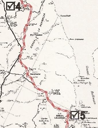
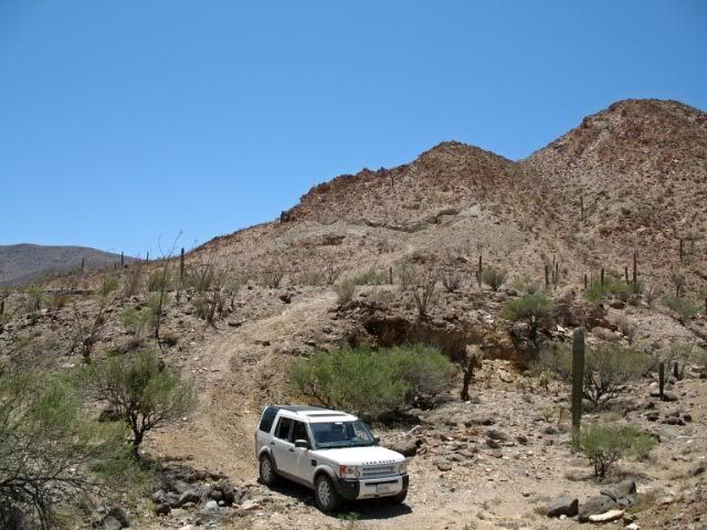
Here is the SCORE map for the Baja 1000 from less than 2 months ago... Checkpoint 4 is Coco's Corner and Checkpoint 5 is Bahia de los Angeles.
The point where it looks like the course touches Hwy. 1 is El Crucero and it does not... there is a parallel dirt road along the east side of Hwy. 1
used for the racers. It runs south to where it meets the old L.A. Bay road and turns left... passes the historic El Desengaño mine...
|
|
|
motoged
Elite Nomad
Posts: 6481
Registered: 7-31-2006
Location: Kamloops, BC
Member Is Offline
Mood: Gettin' Better
|
|
Yeah.....and that stretch just south of El Crucero is a few miles of soft sand whoops....first time through on a dirtbike I almost turned back, not
knowing what was ahead on the way south (I HATE deep sand whoops ) )
Since then, I have learned to grin, curse, and bear it ...the rougher
hardpacked whoops and holes/ruts further south are a blessing compared to the sand....that road comes out at the BoLA road at KM 11 I believe.... ...the rougher
hardpacked whoops and holes/ruts further south are a blessing compared to the sand....that road comes out at the BoLA road at KM 11 I believe....
Coco's to El Crucero 2010 B1000:
http://contour.com/stories/2010-baja-1000-cocos-corner-to-el-crucero
El Crucero to BoLAa:
http://contour.com/stories/2010-baja-1000-el-crucero-to-bay-of-la
Don't believe everything you think....
|
|
|
chrisx
Banned
Posts: 173
Registered: 12-17-2009
Member Is Offline
Mood: baj nomad is broken
|
|
Sound s like a plan. Strong tail wind. My national Geographic (2008) map shows a mission, Calamajue. Photo of ground water. I have a Sawyer in line
drip water purifier, (no moving parts), and the only known water purifier never known to break, miniature tea kettle, complete with bandanna filter.
San Ignacio to Vizcaino is an easy 1 day pedal, even into a head wind. Unfortunately; this is also the last known whereabouts of the fat lady in the
silver Honda. After her high speed fly by, (100 mph), I walked the sand trace next to M1 for 2 kilometers. And yes, I really saw 4 separate
crosses in that 2 k.
Also, I neglected to mention, Although I have the widest 29 inch tires available, 2.55 inches, I can´t really pedal in the sand. Think football coach
standing on a sled yelling at guys to push harder. (Walked the sand trace). Rocks, packed sand, cow path, Honda free area. Even sand for a mile or
3, but not all day. I´m not going to admit turning back from Bahia Tortugas because of deep sand. 1 hour, 1 kilometer = insufficient water.
(SQ)
BR,
Hey, we're just trying to get Chris and his bicycle into deep sand whoops, stinky water, and routes that we love to hate even on motos....so some
misdirection might contribute appropriately lol:" (EQ)
Note to dirt biker, I loaned you buddy my pump last year, even after he tried to pocket my valve core removal tool.
Now, SW from San Ignacio seems to be a multiple choice ¿? Seems as though all roads lead to Honda free adventure down there. (note to fat lady:
large rocks in road). The last tienda ¿20? miles SW of San Ignacio is better stocked than any in town.
Soon I will provide a false start time, and bad directions for my own safety. Until then, consider this, Speedy Gonzales got there first, Slow Poke
Rodrigez had a big piece of cheese and a smile on his face.
http://www.youtube.com/watch?v=ZLdy0GbPtmo
[Edited on 1-6-2011 by chrisx]
|
|
|
bent-rim
Nomad
Posts: 294
Registered: 7-31-2007
Location: Marin County
Member Is Offline
Mood: Living la vida mota
|
|
I'm not sure how you're getting to Coco's, but about 22-23 miles south of Catavina is a trail that heads east and drops down to a wash that will dump
you out near the graded road that leads to Coco's, to the south. If you head north on the graded road it will take you to the Rancho Market in
Gonzaga where you can stock up on supplies. The trail is steep in some sections going downhill. It might be the La Turquesa route that I've seen
mentioned on this site in other threads.
|
|
|
David K
Honored Nomad
Posts: 65591
Registered: 8-30-2002
Location: San Diego County
Member Is Offline
Mood: Have Baja Fever
|
|
| Quote: | Originally posted by bent-rim
I'm not sure how you're getting to Coco's, but about 22-23 miles south of Catavina is a trail that heads east and drops down to a wash that will dump
you out near the graded road that leads to Coco's, to the south. If you head north on the graded road it will take you to the Rancho Market in
Gonzaga where you can stock up on supplies. The trail is steep in some sections going downhill. It might be the La Turquesa route that I've seen
mentioned on this site in other threads. |
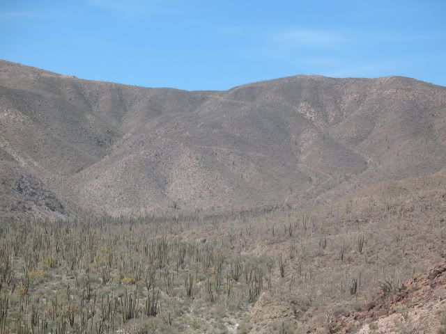
Since he is coming down from San Felipe (see his first post in this thread)... He won't get to enjoy the thrill of the La Turquesa Grade (Kacey's XR
Ride/ Coco's Shortcut)!
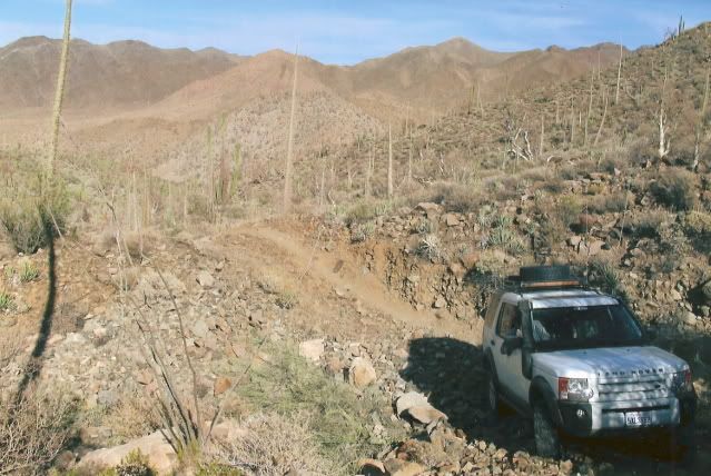
Roy 'TheSquarecircle' with help from TW and others made it UP in his Land Rover after finding and clearing a route from the turquoise mine.
In Feb. 2007, I went from Hwy. 1 (near El Pedregoso) east to the peninsular divide on the abandoned mine road:
There I saw the road dropping down the mountain side... A much better road than I was expecting after reading Kacey's book.
I walked about halfway down the grade to see if it was possible to drive it without a need to turn around. Not being able to see the end, I decided
not to chance it without another vehicle along.
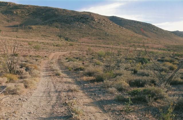
In May, 2007... Roy went in from the Hwy. 5 side, to the turquoise mine and tried to scout a route beyond to the bottom of the grade:
Roy needed more help and time to find the lost road across the valley floor. Nomads Steekers and Ken Cooke made trips in to see if they could get
across.
Steekers took this photo from the turquoise mine area showing the grade coming down the mountain...
Roy, TW and others helping forged a road across the valley from the turquoise mine to the foot of the mountain:
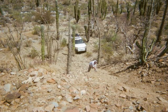
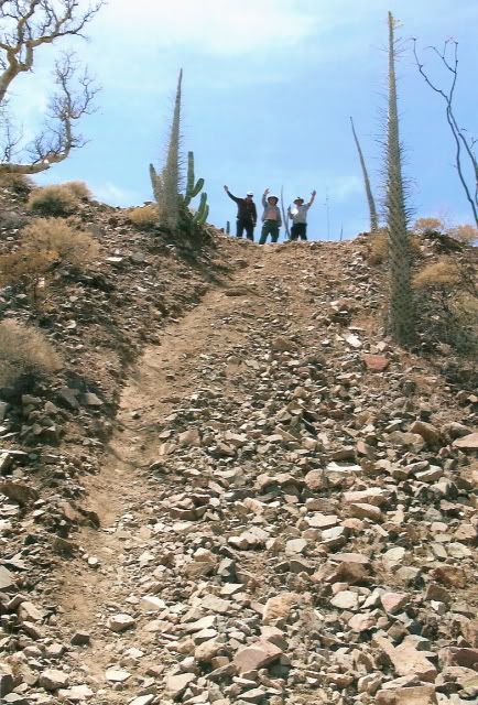
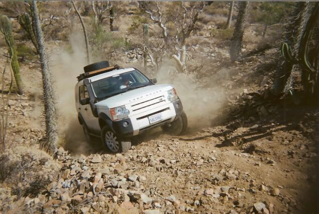
Only motorcycle tracks could be seen on this former mine service road... It was very steep, but the Rover with Roy at the wheel, made it up!
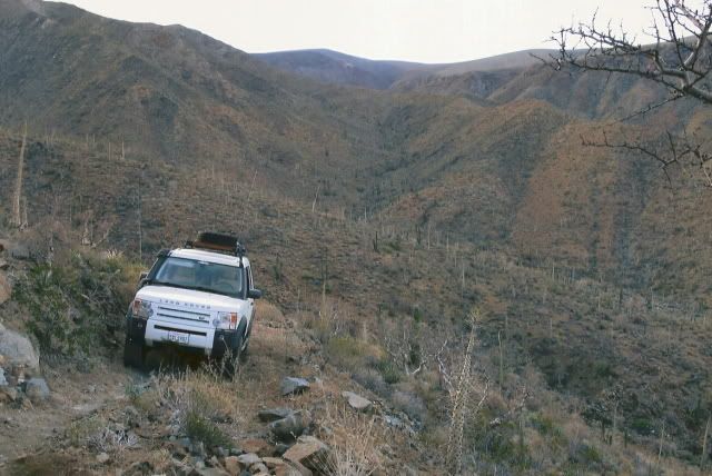
The top of the grade... where I was the previous year...
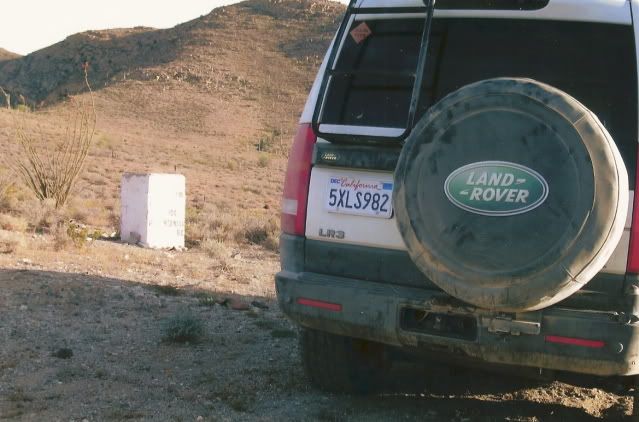
The road on to Hwy. 1:
For more on finding this La Turquesa Canyon shortcut: http://vivabaja.com/207
|
|
|
chrisx
Banned
Posts: 173
Registered: 12-17-2009
Member Is Offline
Mood: baj nomad is broken
|
|
these roads all appear bike / hike a bike able
|
|
|
David K
Honored Nomad
Posts: 65591
Registered: 8-30-2002
Location: San Diego County
Member Is Offline
Mood: Have Baja Fever
|
|
It is just a off road shortcut to get to Gonzaga Bay (or Coco's Corner) from Cataviña/ Hwy. 1
There is also the Camino Real mission 'road' from Mision Santa Maria down to the desert near Gonzaga Bay... It is just a foot trail and is steep in
places.
|
|
|
chrisx
Banned
Posts: 173
Registered: 12-17-2009
Member Is Offline
Mood: baj nomad is broken
|
|
If memory serves, my map shows 3 or 4 missions not to far apart in the South, closer to La Paz. I think one of my darts landed on the map near there.
Not yet time for planning a southern route, hummmmm
|
|
|
David K
Honored Nomad
Posts: 65591
Registered: 8-30-2002
Location: San Diego County
Member Is Offline
Mood: Have Baja Fever
|
|
There are 27 Spanish mission established in Baja and many of them were moved during their operation, and sometimes those get counted as seperate
missions instead of just newer locations.
Calamajue and Santa Maria are the same mission, just two sites... The water at Calamajue was poisonous so crops wouldn't grow there... They moved the
mission up to Santa Maria after a few months... Good water, but not enough land to plant on... When San Fernando was founded 2 years after Santa
Maria, they closed Santa Maria... San Fernando Velicata had lots of land and good water.
|
|
|
Bajatripper
Ultra Nomad
Posts: 3152
Registered: 3-20-2010
Member Is Offline
|
|
| Quote: | Originally posted by David K
The water at Calamajue was poisonous so crops wouldn't grow there... |
David
While I agree with you that the water at Calamajue won't support crops, I believe that it is attributed to its heavy mineral content and not poison.
Clavijero states that the water was undrinkable to Spaniards, so they dug wells about a league away and brought the precious liquid back to the
mission site. But he also says that the natives of the region, not much into digging wells, had no problems surviving on the stuff.
The mineralization is evident by the soda mound on the west side of the canyon wall, where a small spring geyser errupts on top of it. The next time
you're out there, try breaking off a little of the material and dropping it into the water to watch it fizzle away into nothing (I'm easily
entertained, obviously).
So, if our biker friend happens down that canyon, he should be OK if he needs to rely on it for survival. If it turns out that you are right, and the
natives had built up an immunity to the poison, then at least he will become part of the lore that is Baja, a much more interesting way to go than
becoming a hood ornament on a passing motor home
[Edited on 1-6-2011 by Bajatripper]
|
|
|
chrisx
Banned
Posts: 173
Registered: 12-17-2009
Member Is Offline
Mood: baj nomad is broken
|
|
| Quote: | Originally posted by Bajatripper
| Quote: | Originally posted by David K
The water at Calamajue was poisonous so crops wouldn't grow there... |
then at least he will become part of the lore that is Baja, a much more interesting way to go than becoming a hood ornament on a rolling beer can
home
[Edited on 1-6-2011 by Bajatripper] |
¿I wonder, is there a water source information thread/guide here, there, somewhere? perhaps a warning label for bad water thread? Even boiling
doesn't remove high acid content
[Edited on 1-6-2011 by chrisx]
|
|
|
| Pages:
1
2 |


