| Pages:
1
2 |
chrisx
Banned
Posts: 173
Registered: 12-17-2009
Member Is Offline
Mood: baj nomad is broken
|
|
| Quote: | Originally posted by Udo
Here is what I found was a very popular GPS;
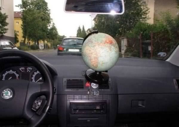 |
si bueno
HEY GRINGO HIT THE BRAKES
SCAN THE ROAD AHEAD AT ALL TIMES
HIT THE BRAKES AND SLOW WAY DOWN
WAIT, PASS WHEN SAFE
HEY GRINGO HIT THE BRAKES!
|
|
|
motoged
Elite Nomad

Posts: 6481
Registered: 7-31-2006
Location: Kamloops, BC
Member Is Offline
Mood: Gettin' Better
|
|
Okay, when you guys are finished joking around, getting it that he isn't asking for paper maps, realize he is asking for GPS maps, and have another
cerveza while you are pleased with your wit and omniscience.....  check out my previously offered link....it surpasses all others mentioned so far:
Don't believe everything you think....
|
|
|
luv2fish
Nomad
Posts: 455
Registered: 5-8-2011
Member Is Offline
|
|
| Quote: | Originally posted by chrisx
Is there a way to block woody from posting? She makes this web page unbearable. |
Chale vato Woody's one of our "Senior" Nomads or "Varsity" players here on the site. Oh and I think Woody is a he and not a she. He actually makes the
site more enjoyable if you will, he and a few other sharks.
|
|
|
805gregg
Super Nomad
Posts: 1344
Registered: 5-21-2006
Location: Ojai, Ca
Member Is Offline
|
|
| Quote: | Originally posted by ElCap
I bought "Baja Navigator" GPS maps for my Garmin from Larry Buck at http://www.lbmaps.com/
They work greta for me, and Larry was very helpful when I had an installation glitch. About $40, and well worth it. [/quote
I agree, these are great. |
|
|
|
chrisx
Banned
Posts: 173
Registered: 12-17-2009
Member Is Offline
Mood: baj nomad is broken
|
|
sounds about right
"THE BEST TOPO MAP FOR OFF ROAD IN MEXICO
OFF-ROAD, 4x4, ATVs, ENDURO, CYCLING, HUNTING, ADVENTURE TOURISM AND MORE "
note to self; read this one again
| Quote: | Originally posted by motoged
Okay, when you guys are finished joking around, getting it that he isn't asking for paper maps, realize he is asking for GPS maps, and have another
cerveza while you are pleased with your wit and omniscience.....
check out my previously offered link....it surpasses all others mentioned so far:
|
HEY GRINGO HIT THE BRAKES
SCAN THE ROAD AHEAD AT ALL TIMES
HIT THE BRAKES AND SLOW WAY DOWN
WAIT, PASS WHEN SAFE
HEY GRINGO HIT THE BRAKES!
|
|
|
Desertbull
Senior Nomad
Posts: 558
Registered: 8-27-2003
Member Is Offline
|
|
I think the reason for the whimsical responses and not a serious response is because most people don't want to give up their own GPS info and trails
etc. Many people have an incredible amount of hours invested in their GPS systems, files and maps.
Anyway, an easy solution is offered by PCI Race Radios in Long Beach, Ca. They offer a download that you purchase and then upload to your GPS. It's
available in GPX (Garmin) or USR (Lowrance).
This file contains the entire Baja Peninsula, every town, highways, villages, dirt roads, fishing villages, containing streets etc. It also contains
the majority of general dirt trails of Baja. It's not cheap, but consider that someone had to do all the work sometime. I'm not affiliated with PCI,
but I do know that it works excellent as I have it and use it in all my GPS units.
Take into consideration that many of the tour guys all have their own GPS files of back trails, crossover trails from Pacific to Sea od Cortez and
beach routes. And no one wants to share their "secret" GPS files.
Hope this helps!
http://www.pciraceradios.com/ProductDetail.jsp?LISTID=480051...
DREAM IT! PLAN IT! LIVE IT!
|
|
|
bajaguy
Elite Nomad
Posts: 9247
Registered: 9-16-2003
Location: Carson City, NV/Ensenada - Baja Country Club
Member Is Offline
Mood: must be 5 O'clock somewhere in Baja
|
|
I would not venture anywhere with just a GPS. Good paper topo maps used with a GPS are the way to go.
|
|
|
chrisx
Banned
Posts: 173
Registered: 12-17-2009
Member Is Offline
Mood: baj nomad is broken
|
|
Suunto MC-2 Global
no batteries needed
works every place
| Quote: | Originally posted by bajaguy
I would not venture anywhere with just a GPS. Good paper topo maps used with a GPS are the way to go. |
si bueno
HEY GRINGO HIT THE BRAKES
SCAN THE ROAD AHEAD AT ALL TIMES
HIT THE BRAKES AND SLOW WAY DOWN
WAIT, PASS WHEN SAFE
HEY GRINGO HIT THE BRAKES!
|
|
|
motoged
Elite Nomad
Posts: 6481
Registered: 7-31-2006
Location: Kamloops, BC
Member Is Offline
Mood: Gettin' Better
|
|
| Quote: | Originally posted by Desertbull
I think the reason for the whimsical responses and not a serious response is because most people don't want to give up their own GPS info and trails
etc. Many people have an incredible amount of hours invested in their GPS systems, files and maps. .... |
I like the joking
He just isn't asking for private track logs or secret spots....just GPS map software....he will make his own files, or not ....entering spots where
fat ladies in Hondas present unlimited danger, speeders are recklessly drinking and driving, areas where no one can pedal a bicycle in soft sand, and
points of interest only he would want to remember. 
Don't believe everything you think....
|
|
|
CortezBlue
Super Nomad
Posts: 2213
Registered: 11-14-2006
Location: Fenix/San Phelipe
Member Is Offline
|
|
| Quote: | Originally posted by chrisx
I finaly got a GPS.
Some where in the world I expect maps of Baja exist. No no, not the city street maps Garmin sells. Some back country topo style maps with hills and
mountains and such.
Up until now I've been getting by on navigation tactics straight from the 1859 Cavalry manual.
Day in the life
My map Shows a road heading south through the mountains. You know, travel east for 11 or 12 miles, turn right travel another 15 etc. 6 or 7 miles
along and I'm on a trail instead of a road. This does not match my map exactly. When does Baja match my map? The pointed mountain off in the
distance seems to be on the map, only a few points east of where I think it should be. The trail turns into a sand creek bed. Dry soft deep hard to
push a bicycle through sand.
Best to turn back. 10 miles of sand or 50 miles of road take about the same amount of time. On the road again and a little thirsty. What happened
to my water? My ten mile search pattern is not succesful. The river of sand must have swallowed my last bottle of water. I have some serious bike
lights, this seems like the right time to use them. 5 hours into the dark I find a place to make camp.
Somebody must know something about gps and maps and Baja? |
Silly Gringo, don't you know that most GPS companies don't know that Mexico is in North America?
I bought a GPS that said, with North America maps. It included Canada and USA. I called, and even the customer support person argued with me that,
first, Mexico was in South America and then, no, Central America. I had to talk her into looking on Google 'til she agreed with me.
However, that being said, do you have an Android or Iphone?
I just downloaded TomTom for my Iphone with Mexico maps and it was pretty good. Now, it will not have off road places that many folks discuss on
here, but it does have the main highways etc.
Good Luck
|
|
|
bigzaggin
Nomad
Posts: 441
Registered: 5-27-2004
Member Is Offline
Mood: way too ites
|
|
| Quote: | Originally posted by David K
| Quote: | Originally posted by Bajatripper
What you need is a Baja California Almanac, usually available from Discover Baja in San Diego. They run about $25.
If you are really lucky, you might get ahold of a Baja Explorer Topographic Atlas Directory, which has been out of print for a while. It has the
largest scale I've come across of the peninsula, but is somewhat dated now. |
Here they all are... all produced by Landon Crumpton...
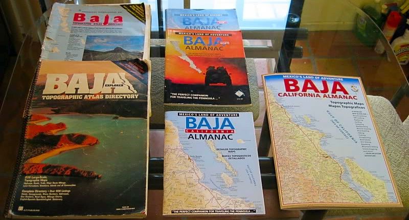
There have been three sizes (scales)... The orig. Baja Topo Atlas was the larges and most detailed sacle, and the biggest pages. The next two versions
had a smaller scale, and 8.5 x 11 inch pages. The newest version has an even smaller scale (the least detail) and went to a bigger size page.
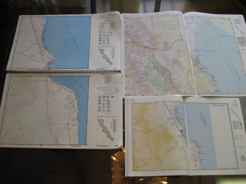
The three scales of the same region (San Felipe). |
How on earth do you still have Almanacs with the cover intact? I typically lose mine on trip #2, when hurriedly re-shoving the thing into the side of
the door at some fork in the washboards.
|
|
|
chrisx
Banned
Posts: 173
Registered: 12-17-2009
Member Is Offline
Mood: baj nomad is broken
|
|
http://www.youtube.com/watch?v=5Z8nhritrso
Gps tracks of baja pavement are like maps of a grocery store, something few people need.
In zona de no fat lady:
the road on the ground and the roads on the map some times do not match. Being lost is more of a blessing than a curse, until the water is gone.
Sometimes the road turns to sand, sometimes the river is the road, sometimes the map shows a road where there is none, sometimes there is a road where
the map shows none.
HEY GRINGO HIT THE BRAKES
SCAN THE ROAD AHEAD AT ALL TIMES
HIT THE BRAKES AND SLOW WAY DOWN
WAIT, PASS WHEN SAFE
HEY GRINGO HIT THE BRAKES!
|
|
|
David K
Honored Nomad
Posts: 65591
Registered: 8-30-2002
Location: San Diego County
Member Is Offline
Mood: Have Baja Fever
|
|
| Quote: | Originally posted by bigzaggin
How on earth do you still have Almanacs with the cover intact? I typically lose mine on trip #2, when hurriedly re-shoving the thing into the side of
the door at some fork in the washboards. |
The cover of the first edition Baja Topo Atlas is indeed torn off the ring binding after just small amount of use... The second edition stays in my
book collection here.
The 1998-ish 2 book Baja Almanacs... the Norte one is held together with duct tape and is marked up with my notes... but I have a second, pristine
one. The Sur is in good shape.
The 2003 edition, well it has a torn cover with duct tape and notes inside, but I have a second pristine copy!
The bigger 2009 edition... well I bought 3 copies when they came out... one copy has my notes in it (the latitude figures were wrong on several of the
maps).
I often get second copies of Baja books... gave many to Antonio (BajaCactus) for his future Baja Library in El Rosario... and I gave away some books
for door prize raffles at my Viva Baja parties... including a Sea of Cortez by Ray Cannon!
The secret is to go to used book stores!
|
|
|
Fernweh
Nomad
Posts: 444
Registered: 2-24-2011
Location: Centenario, BCS
Member Is Offline
|
|
I like to use a laptop when traveling the Baja and have Google Earth running......
I do have to scan the area I like to visit into GE's cache when still online and use that saved cache file (max 2G) when offline.
Two small nifty programs are part of my set-up:
GPS for Google Earth and Cache for Google Earth
you'll find both here: http://www.drregener.com/en/
Together with a small Bluetooth GPS receiver I then can track my route/position in real time on that "cache map".
It works anywhere, not just down the Baja.
Karl
|
|
|
Desertbull
Senior Nomad
Posts: 558
Registered: 8-27-2003
Member Is Offline
|
|
| Quote: | Originally posted by motoged
| Quote: | Originally posted by Desertbull
I think the reason for the whimsical responses and not a serious response is because most people don't want to give up their own GPS info and trails
etc. Many people have an incredible amount of hours invested in their GPS systems, files and maps. .... |
I like the joking
He just isn't asking for private track logs or secret spots....just GPS map software....he will make his own files, or not ....entering spots where
fat ladies in Hondas present unlimited danger, speeders are recklessly drinking and driving, areas
where no one can pedal a bicycle in soft sand, and points of interest only he would
want to remember. |
The maps from PCI are very detailed for public use, but I know many people who use "other" self constructed digital maps, which have been tediously
triangulated using known Baja waypoints, for mobile use with the iPad and many different GPS's, all which allow for really cool real time tracking
without mobile Internet even in Baja...so I was trying to say that their is private GPS map software that is way more advanced then you could imagine,
and those files are kept close by many, so the PCI files will work.
I have been using the iPad exclusively since it's release and with the software and maps that have been shared with us, all I can say "wow.". The
iPad is widely used
by pilots around the globe...similar technology in use on the ground in Baja. No
Internet needed. :-)
DREAM IT! PLAN IT! LIVE IT!
|
|
|
David K
Honored Nomad
Posts: 65591
Registered: 8-30-2002
Location: San Diego County
Member Is Offline
Mood: Have Baja Fever
|
|
Nobody has mentiond Kacey Smith's books: All About Your Whereabouts (The Baja GPS Guide) Volume 1 & 2. (Vol. 2 is an e-book)
http://www.bajagpsguide.com
Primarily for motorbike riders, but many roads included.
[Edited on 8-2-2011 by David K]
|
|
|
tripledigitken
Ultra Nomad
Posts: 4848
Registered: 9-27-2006
Member Is Offline
|
|
| Quote: | Originally posted by Desertbull
| Quote: | Originally posted by motoged
| Quote: | Originally posted by Desertbull
I think the reason for the whimsical responses and not a serious response is because most people don't want to give up their own GPS info and trails
etc. Many people have an incredible amount of hours invested in their GPS systems, files and maps. .... |
I like the joking
He just isn't asking for private track logs or secret spots....just GPS map software....he will make his own files, or not ....entering spots where
fat ladies in Hondas present unlimited danger, speeders are recklessly drinking and driving, areas
where no one can pedal a bicycle in soft sand, and points of interest only he would
want to remember. |
The maps from PCI are very detailed for public use, but I know many people who use "other" self constructed digital maps, which have been tediously
triangulated using known Baja waypoints, for mobile use with the iPad and many different GPS's, all which allow for really cool real time tracking
without mobile Internet even in Baja...so I was trying to say that their is private GPS map software that is way more advanced then you could imagine,
and those files are kept close by many, so the PCI files will work.
I have been using the iPad exclusively since it's release and with the software and maps that have been shared with us, all I can say "wow.". The
iPad is widely used
by pilots around the globe...similar technology in use on the ground in Baja. No
Internet needed. :-) |
Very interesting use of the iPad. What GPS do you use for this setup? No reason this couldn't be done with a laptop I suppose. Please explain how
the GPS interfaces with the cached maps, and what program is used for that. Pardon me if I missed that in the explanation.
Ken
|
|
|
wilderone
Ultra Nomad
Posts: 3915
Registered: 2-9-2004
Member Is Offline
|
|
"the road on the ground and the roads on the map some times do not match. Being lost is more of a blessing than a curse, until the water is gone.
Sometimes the road turns to sand, sometimes the river is the road, sometimes the map shows a road where there is none, sometimes there is a road where
the map shows none. "
Such is the lure and adventure of Baja CA. I would add to that - wish all the squiggly blue lines on a topo meant there was actually water in these
waterways. You have come to the correct conclusion - carry extra water and enjoy the adventure.
|
|
|
Desertbull
Senior Nomad
Posts: 558
Registered: 8-27-2003
Member Is Offline
|
|
| Quote: | Originally posted by tripledigitken
| Quote: | Originally posted by Desertbull
| Quote: | Originally posted by motoged
| Quote: | Originally posted by Desertbull
I think the reason for the whimsical responses and not a serious response is because most people don't want to give up their own GPS info and trails
etc. Many people have an incredible amount of hours invested in their GPS systems, files and maps. .... |
I like the joking
He just isn't asking for private track logs or secret spots....just GPS map
software....he will make his own files, or not ....entering spots where fat ladies in
Hondas present unlimited danger, speeders are recklessly drinking and driving, areas
where no one can pedal a bicycle in soft sand, and points of interest only he would
want to remember. |
The maps from PCI are very detailed for public use, but I know many people who use "other" self constructed digital maps, which have been tediously
triangulated using known Baja waypoints, for mobile use with the iPad and many different GPS's, all which allow for really cool real time tracking
without mobile Internet even in Baja...so I was trying to say that their is private GPS map software that is way more advanced then you could imagine,
and those files are kept close by many, so the PCI files will work.
I have been using the iPad exclusively since it's release and with the software and maps that have been shared with us, all I can say "wow.". The
iPad is widely used
by pilots around the globe...similar technology in use on the ground in Baja. No
Internet needed. :-) |
Very interesting use of the iPad. What GPS do you use for this setup? No reason this couldn't be done with a laptop I suppose. Please explain how
the GPS interfaces with the cached maps, and what program is used for that. Pardon me if I missed that in the explanation.
Ken |
The iPad and the GNS 5870 MFI GPS-Bluetooth along with several different software Apps have been widely used in the aviation field. Those super smart
pilot types are the guys that figured this all out, me and my friends have just adopted it for use in Baja using the maps we created, I've chatted
with others who have used this system as well. We create our maps using OziXplorer software.
For use on the iPad we use the GPX Motion HD App found in the iTunes App Store. You simply download the GPX Motion App and upload your selection of
cached maps via GPX, they have an easy to use procedure for uploading that is detailed in their software.
The GPS is the GNS 5870 MFI GPS BT Receiver Reliable GPS - See Below Cut and Paste info on the GPS. I purchased the GNS 5870 for $90 from an aviation
supply company.
__________________________________________________________________
Now "waas" Enabled!
Transform your iPad, iPhone or iPod into a precise and fast navigation system. With the new wireless GNS 5870 MFI for the first time a portable
highly-sensitive Hybrid-GPS receiver with Bluetooth technology for different Apple devices is available. The new GNS 5870 MFI is fully certified by
Apple. The GNS 5870 MFI GPS-Bluetooth receiver works with the Apple iPad, iPhone 3G, iPhone 3GS (as of iPhone OS 3.0.1), iPod touch 2G, iPod touch 3G
and with other Bluetooth-capable handhelds such as smartphones, notebooks and PDAs. The quality seal "Made for iPod/iPhone/iPad guarantees full
compatibility to Apple products.
The GNS 5870 MFI has a high-sensitive 32-channel GPS chip and a high-quality Bluetooth interface. And even under difficult reception conditions such
as near high buildings, the receiver allows reliable and wireless GPS reception. With an operating time of more than 10 hours you can use the receiver
especially for outdoor pursuits, such as for mountain-bike or hillwalk navigation. Efficient power management means that the receiver switches itself
off when there is no Bluetooth connection.
The GNS 5870 MFI always communicates wirelessly via Bluetooth. For your iPad, iPhone or iPod touch you must only set up once the connection to the
receiver. After that the receiver automatically connects with your Apple device. For additional comfort the GNS 5870 MFI is operated via Smart Touch
Technology. You can switch the receiver on or off only by moving your finger over the touch panel. With its small and light-weight form, the receiver
is a reliable and convenient GPS solution ideal for use in cars or motor homes, on motorcycles, bicycles or on foot.
DREAM IT! PLAN IT! LIVE IT!
|
|
|
tripledigitken
Ultra Nomad
Posts: 4848
Registered: 9-27-2006
Member Is Offline
|
|
Desertbull,
Thanks very much for the information.
Ken
|
|
|
| Pages:
1
2 |