| Pages:
1
2
3
4
5
6 |
TMW
Select Nomad

Posts: 10659
Registered: 9-1-2003
Location: Bakersfield, CA
Member Is Offline
|
|
Presidents weekend is good for me, but I'm flexable.
|
|
|
El Comadante Loco
Nomad
Posts: 274
Registered: 6-12-2004
Member Is Offline
|
|
Thanks TW.. OK we have Pres day in Feb.. I am ok with this date.. How about the rest of you.. Keep dates comining...
|
|
|
David K
Honored Nomad
Posts: 65590
Registered: 8-30-2002
Location: San Diego County
Member Is Online
Mood: Have Baja Fever
|
|
Reviewing this thread, Gonzaga to Mision Santa Maria via El Camino Real (west of Punta Final, on the north rim of Santa Maria Canyon) and on to Santa
Ynez or Gonzaga to Santa Ynez via Junipero Serra's Cargo Trail (passes to the north of the mission from near Papa Fernandez')?
The cargo trail was developed to support the new Franciscan mission of San Fernando Velicata, and does not go through Santa Maria... It is a more
direct route from near Papa Fernandez' to Santa Ynez... It joins the Santa Maria road/ El Camino Real just east of the high point in the Santa
Ynez-Santa Maria road, or about 11 miles from Santa Ynez.
Baja Bucko has traveled the Cargo Trail from end to end (even placed a 'geo-cache' along it, about 10 years ago).
It is probably best to allow at least 3 days to walk from Gonzaga to Santa Ynez using either route. Another 3 to the Pacific... and a day or two to
return north...
This will be a week+, long event overall...
The GeoCache page: http://www.geocaching.com/seek/cache_details.aspx?guid=ca585...
One photo where Baja Bucko hid the cache in 2001:

[Edited on 8-11-2011 by David K]
|
|
|
TMW
Select Nomad
Posts: 10659
Registered: 9-1-2003
Location: Bakersfield, CA
Member Is Offline
|
|
Rudy where did you want to start the walk from the water at Gonzaga Bay?
|
|
|
El Comadante Loco
Nomad
Posts: 274
Registered: 6-12-2004
Member Is Offline
|
|
| Quote: | Originally posted by TW
Rudy where did you want to start the walk from the water at Gonzaga Bay? |
My thought is to start the hike from the trail head up to the mission.. I think it is about 5-7 miles from Gonzaga.. David K knows where it is..
Once we get dropped of the support vehicles can go around and meet us at the mission if they can get past the bog.. If not we can hike up the hill
to meet the trucks.. What do you think???
Let's hear from others who are interested.. Thus far we are looking at Pres, Day,,,
|
|
|
Bajatripper
Ultra Nomad
Posts: 3152
Registered: 3-20-2010
Member Is Offline
|
|
My wife and I will make an effort to be there. But, like a few others, it depends on how our finances line up at that time. Sounds like a lot of fun.
There most certainly is but one side to every story: the TRUTH. Variations of it are nothing but lies.
|
|
|
David K
Honored Nomad
Posts: 65590
Registered: 8-30-2002
Location: San Diego County
Member Is Online
Mood: Have Baja Fever
|
|
| Quote: | Originally posted by El Comadante Loco
| Quote: | Originally posted by TW
Rudy where did you want to start the walk from the water at Gonzaga Bay? |
My thought is to start the hike from the trail head up to the mission.. I think it is about 5-7 miles from Gonzaga.. David K knows where it is..
Once we get dropped of the support vehicles can go around and meet us at the mission if they can get past the bog.. If not we can hike up the hill
to meet the trucks.. What do you think???
Let's hear from others who are interested.. Thus far we are looking at Pres, Day,,, |
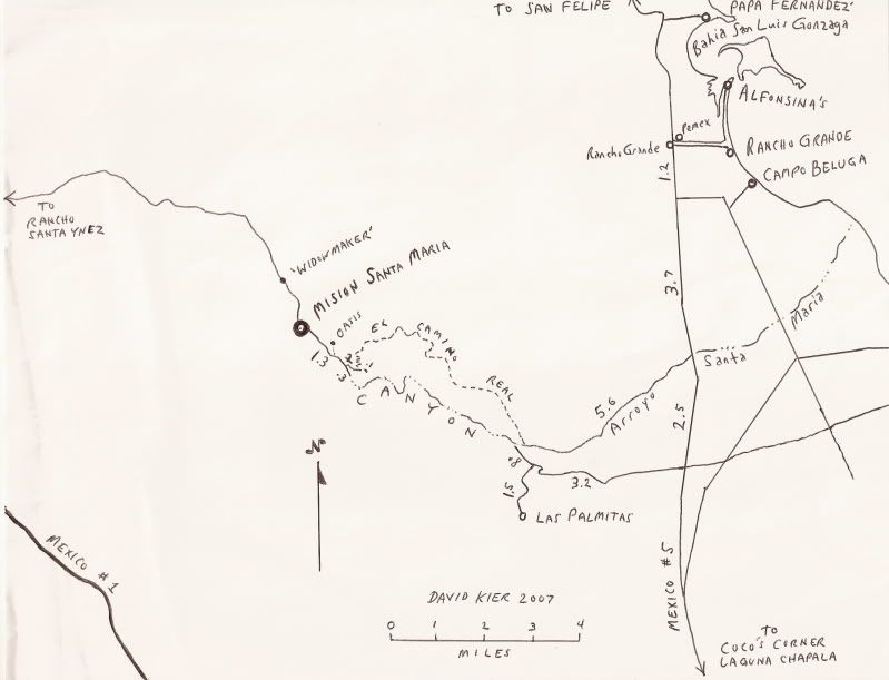
The trail is the El Camino Real post 1769... the dashed line on my map. The easiest way to reach the start of the trail is to use the Las Palmitas
road, just over 7 miles south of Rancho Grande/ Pemex station... then go 4.0 miles east to the parking spot at the edge of the white sand arroyo
(Arroyo Santa Maria). A large boulder is next to this spot and is located at the point where the road drops into the sand.
This is the entrance to the canyon, and you could hike up the canyon, but that is harder and requires wading through deep water.
If you hike the El Camino Real, there is no water, but it would be the easier route to the mission... Allow 6 hours for the hike to the mission. The
trail begins across the white sand arroyo from the parking spot, on the north bank... Look for cattle tracks converging to the one point where they
(and you) can climb out of the big Arroyo Santa Maria.
The Camino Real stays in in the hills above the north rim of the canyon... and there are places where it vanishes and reappears... Myself and Don
Jorge hiked it in 2003 (me about 2/3 of it and him, all the way). Rock piles (ducks) mark it where the Franciscan trail is hard to spot. (The Jesuits
weren't in Baja long enough after founding Santa Maria to build their famous high quality road to it).
See http://vivabaja.com/1103 for more on my hike on it.
GPS Directions (map datum NAD27 Mexico)
Take Hwy. 5 south 7.4 miles from Rancho Grande, turn west: 29°41.094'/ 114°24.566'
3.2 miles west of Hwy. 5, go straight where most traffic curves left for Las Palmitas: 29°41.278'/ 114°27.639'
0.8 miles from above, park at huge boulder: 29°41.68'/ 114°28.20'
Hike to north bank of Arroyo Santa Maria to: 29°41.733'/ 114°28.175' elev. 609' (ECR-1)
Go northwest and climb out of valley, note ocotillos.
Along left side of side valley: 29°42.374'/ 114°28.566' elev. 741' (ECR-2)
On first padre built switchback up: 29°42.669'/ 114°28.937' elev. 906' (ECR-3)
On a ridge, trail continues northwest: 29°42.671'/ 114°29.425' elev. 1308' (ECR-4)
On the Camino Real: 29°42.748'/ 114°29.482' elev. 1391' (ECR-5)
Crossing ridges and little mesas: 29°43.008'/ 114°29.967' elev. 1477' (ECR-6)
Drop along side of ridge, trail narrow: 29°43.074'/ 114°30.128' elev.1610' (ECR-7)
End of today's hike just beyond this last clear sign of the old trail: 29°43.141'/ 114°30.189' elev. 1702' (ECR-8)
Junction of ECR & bulldozed road: 29°43.126'/ 114°31.753' elev.1413'
(End of bulldozed road, on canyon ridge: 29°43.033'/ 114°31.556' elev. 1,615' )
Mision Santa Maria: 29°43.891'/ 114°32.794' elev.1628'
[Edited on 8-12-2011 by David K]
|
|
|
TMW
Select Nomad
Posts: 10659
Registered: 9-1-2003
Location: Bakersfield, CA
Member Is Offline
|
|
| Quote: | Originally posted by El Comadante Loco
My thought is to start the hike from the trail head up to the mission.. I think it is about 5-7 miles from Gonzaga.. David K knows where it is..
Once we get dropped of the support vehicles can go around and meet us at the mission if they can get past the bog.. If not we can hike up the hill
to meet the trucks.. What do you think??? |
That sounds good to me and DK gave us the directions above.
|
|
|
David K
Honored Nomad
Posts: 65590
Registered: 8-30-2002
Location: San Diego County
Member Is Online
Mood: Have Baja Fever
|
|
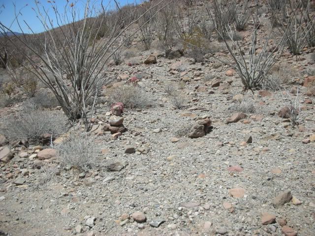
The start of the trail... from Nov. 2002:

Three cattle trails cross Arroyo Santa Maria and converge at the only place where a climb out of the arroyo is possible. This was on my second day
searching, and the reward was worth it.
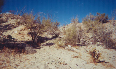
This second climb takes you out of the Santa Maria river valley and into a higher side side valley heading northwest. Ocotillos line the trail just
ahead.

This sign says it all! It was laying along the El Camino Real about a half mile up from Arroyo Santa Maria. I continued hiking, with a big smile on my
face!
Ahead to Mision Santa Maria

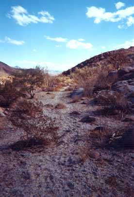
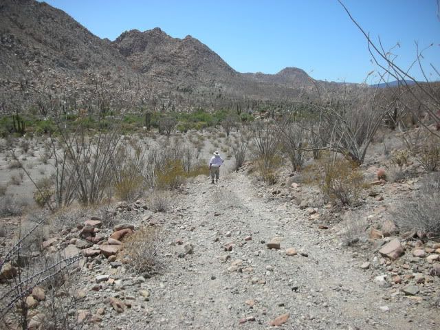
Looking back to the southeast. This was the Baja Highway, before automobiles.
|
|
|
David K
Honored Nomad
Posts: 65590
Registered: 8-30-2002
Location: San Diego County
Member Is Online
Mood: Have Baja Fever
|
|
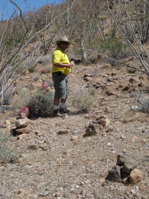
The other end of ECR at the mission valley
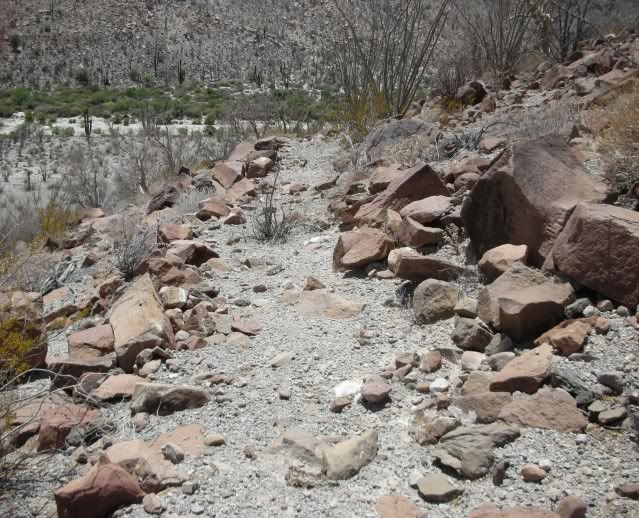
Here is the Camino Real as it switchbacks down the steep hillside to the mission valley.
Here is where it joins the auto road from the mission (looking from the road to the ECR).
Here is the road looking towards the mission... it is 1.5 miles from here.
Last year:
Where ECR meets the road from the mission.
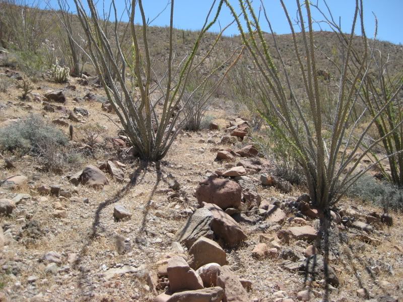
An ocotillo growing in the the padre's trail.
[Edited on 8-12-2011 by David K]
|
|
|
mcfez
Elite Nomad
Posts: 8678
Registered: 12-2-2009
Location: aka BN yankeeirishman
Member Is Offline
|
|
David...if I get tired during this hike.....will you carry me?
I cant believe the library of maps and photos you have acquired over the years. Just great stuff.
Old people are like the old cars, made of some tough stuff. May show a little rust, but good as gold on the inside.
|
|
|
David K
Honored Nomad
Posts: 65590
Registered: 8-30-2002
Location: San Diego County
Member Is Online
Mood: Have Baja Fever
|
|
| Quote: | Originally posted by mcfez
David...if I get tired during this hike.....will you carry me?
I cant believe the library of maps and photos you have acquired over the years. Just great stuff. |
No. 
Thanks... It has been my life's passion, the collection of Baja books and maps... and to travel to the interesting places of Baja and make my own maps
or travel logs of them. Obviously, our favorite area is 15-25 miles south of San Felipe, so most of my maps and photos are of that area.
|
|
|
El Comadante Loco
Nomad
Posts: 274
Registered: 6-12-2004
Member Is Offline
|
|
David, you are a wealth of information and your willingness to share it will all of us is selfless and exemplary. We need you on this hike and
sincerely hope you can make it..
About 9 years ago we started at the trail head west of punta final and made to the mission by late afternoon carrying all of our gear including water
and without any support trucks to meet us there. The next day we hiked out via the wash, what a mistake, it was much more difficult than the padre
trail but it was beautiful and worth the effort.
I agree we need to give this hike at least one week however since there are two parts to this hike if individuals can not take the whole week they
can do either the first or second half of the trek...
Rudy
|
|
|
David K
Honored Nomad
Posts: 65590
Registered: 8-30-2002
Location: San Diego County
Member Is Online
Mood: Have Baja Fever
|
|
| Quote: | Originally posted by El Comadante Loco
David, you are a wealth of information and your willingness to share it will all of us is selfless and exemplary. We need you on this hike and
sincerely hope you can make it..
About 9 years ago we started at the trail head west of punta final and made to the mission by late afternoon carrying all of our gear including water
and without any support trucks to meet us there. The next day we hiked out via the wash, what a mistake, it was much more difficult than the padre
trail but it was beautiful and worth the effort.
I agree we need to give this hike at least one week however since there are two parts to this hike if individuals can not take the whole week they
can do either the first or second half of the trek...
Rudy |
Excellent point! Gulf Half and the Pacific half with Rancho Santa Ynez and Cataviña in the middle. I would love to help or be there, but things would
really need to change for me business-wise to take a week off (or even have money to go at all!!).
|
|
|
TMW
Select Nomad
Posts: 10659
Registered: 9-1-2003
Location: Bakersfield, CA
Member Is Offline
|
|
I'll supply you with beer.
|
|
|
El Comadante Loco
Nomad
Posts: 274
Registered: 6-12-2004
Member Is Offline
|
|
| Quote: | Originally posted by TW
I'll supply you with beer. |
and food!!!!
|
|
|
mcfez
Elite Nomad
Posts: 8678
Registered: 12-2-2009
Location: aka BN yankeeirishman
Member Is Offline
|
|
I'll supply the crazy campfire stories for you
Old people are like the old cars, made of some tough stuff. May show a little rust, but good as gold on the inside.
|
|
|
David K
Honored Nomad
Posts: 65590
Registered: 8-30-2002
Location: San Diego County
Member Is Online
Mood: Have Baja Fever
|
|
I will do my best to be there, thank you my friends!
|
|
|
TMW
Select Nomad
Posts: 10659
Registered: 9-1-2003
Location: Bakersfield, CA
Member Is Offline
|
|
Big 5 had a sale on the little handy talky radios, two for $25 so I picked up a couple of sets. Can use them when the grandkids come out to camp and
hike. Also when we do our hike. Says they work up to 20 miles depending on terrain.
|
|
|
TMW
Select Nomad
Posts: 10659
Registered: 9-1-2003
Location: Bakersfield, CA
Member Is Offline
|
|
Don't want this to get lost our leader, El Comadante Loco, may forget about it.
|
|
|
| Pages:
1
2
3
4
5
6 |


