| Pages:
1
2 |
BAJACAT
Ultra Nomad

Posts: 2902
Registered: 11-21-2005
Location: NATIONAL CITY, CA
Member Is Offline
|
|
LAGUNA SALADA-LAGUNA HANSON VIA PARRA CANYON
Has anybody gone this way to reach Laguna Hanson from laguna Salada, the name of the canyon is PARRA, the entrance is about 8 or 9 miles south of the
entrance to PALOMAR canyon, the map shows a rd from Salada to Cerro prieto and maybe it connects to hanson, anybody MICK, KEN COKE, BARRY,JOHN M..

BAJA IS WHAT YOU WANTED TO BE, FUN,DANGEROUS,INCREDIBLE, REMOTE, EXOTIC..JUST GO AND HAVE FUN.....
|
|
|
Neal Johns
Super Nomad
Posts: 1687
Registered: 10-31-2002
Location: Lytle Creek, CA
Member Is Offline
Mood: In love!
|
|
Yes, twice, but the name is El Mano Canyon on the Baja Almanac.
The first few miles over the foothills are on a road over small bedrock ledges a few inches high which get really tiresome fast. Large fat tires help
but any stock 4x4 can make it. After that, the two track is not bad. There is a cable that can be strung between two post to block the road (after the
bad part  :lol :lol but on my trips a few years ago, a couple of years apart, it looked like it had never been used in years. but on my trips a few years ago, a couple of years apart, it looked like it had never been used in years.
There is a house on the left half way up used only for storage of hay.
Further up, there is a locked gate. Panic! But it turned out to be a side road and the road left took us on up.
On Google Earth, set your Eye Altitude below 40,000 feet and the road to Laguna Hansen will be highlighted if Roads are checked in Layers.
It is a trip everyone should do once, but only once.
At the top, the roads are good, but many are not on any map. We followed signs to some resort backwards and ended up on Hwy. 3. It's fun to be a
little lost. If you speak Spanish, there is a house near where you get to the top.
Edit: The start of the road is easy to find, just bypass the entrance to Guadalupe and continue south about 20 miles, passing Cajabuzo Junction race
checkpoint and continue south about eight miles until you pass a small dark butte (visible on Google Earth at 31 deg 49.73 min and 115 deg 33.81 min
The El Mano road goes southwest off the main road south, and in about four miles, makes a hard right turn, crosses the wash and ascends the hills.
[Edited on 3-17-2009 by Neal Johns]
[Edited on 3-17-2009 by Neal Johns]
[Edited on 3-17-2009 by Neal Johns]
My motto:
Never let a Dragon pass by without pulling its tail!
|
|
|
MICK
Nomad
Posts: 499
Registered: 11-12-2003
Location: Rio Hardy
Member Is Offline
Mood: livin the good life on the river
|
|
I agree with Neal. I did it once and don't plan on doing it anytime soon. Like all baja back roads they change weekly. We came across a guy in a car
up on top that made our trip to Hwy 3 a little easier. If you try it I would camp somewhere along the way to break it up
Have fun and take several vehicles if you try it
Mick
Getting there is ALL the fun!
Ok being here is fun to
|
|
|
David K
Honored Nomad
Posts: 65591
Registered: 8-30-2002
Location: San Diego County
Member Is Offline
Mood: Have Baja Fever
|
|
Jose, if it is El Mano canyon you are talking about... I have a GPS of the points taken when I came down it to get to Guadalupe Canyon after the '03
Baja 500 we watched up by Agua Blanca... on my web site GPS list.
The Almanac does show a canyon of PARRA just south of El Mano... but no road in it.
|
|
|
Ken Cooke
Elite Nomad
Posts: 8971
Registered: 2-9-2004
Location: Riverside, CA
Member Is Offline
Mood: Pole Line Road postponed due to injury
|
|
Jose, this sounds like an adventure!! 
Have a great time out there. The weather should be perfect.
|
|
|
BAJACAT
Ultra Nomad
Posts: 2902
Registered: 11-21-2005
Location: NATIONAL CITY, CA
Member Is Offline
|
|
Thanks everybody, and Neal, I will consider the trip and yes I will not dare to go solo, I found some pictures of some guys that did it it it looks
interesting, i still want to go to Palomar and photograph the Petroglyphs..
BAJA IS WHAT YOU WANTED TO BE, FUN,DANGEROUS,INCREDIBLE, REMOTE, EXOTIC..JUST GO AND HAVE FUN.....
|
|
|
yukonrob
Newbie
Posts: 8
Registered: 2-23-2011
Member Is Offline
|
|
Sorry to resurrect an old thread...we're looking to do L. Salada to L. Hanson in mid October. Any more recent trail reports or general info? A group
of us might head down early and do a side trip to Guadalupe also.
Thanks in advance,
Rob
|
|
|
Neal Johns
Super Nomad
Posts: 1687
Registered: 10-31-2002
Location: Lytle Creek, CA
Member Is Offline
Mood: In love!
|
|
Nothing new to add except exact Google Earth long/lat of the El Mano road junction starting South is 31° 49.725'N 115° 33.812'W (normal GE Datum WGS
84) and it is readily visible on Google Earth. Have not been up there in years.
Neal
My motto:
Never let a Dragon pass by without pulling its tail!
|
|
|
David K
Honored Nomad
Posts: 65591
Registered: 8-30-2002
Location: San Diego County
Member Is Offline
Mood: Have Baja Fever
|
|
Here is part of the page of waypoints that take you from Guadalupe Canyon up to Hwy. 3 via Mano Canyon... this is from 2003 and the map datum is set
at NAD27 Mexico:
Guadalupe Canyon Entrance: 32°09.40'/ 115°47.29'
Cohabuzo Jcn: 31°55.74'/ 115°36.22'
South of Cohabuzo 8.2 mi. is a fork, go right for El Mano (4WD): 31°49.81'/ 115°33.89'
Jcn. with road to left. Ahead-right goes up the mountain via El Mano canyon: 31°47.68'/ 115°36.65'
Rancho El Mano driveway left, road begins major climb: 31°48.56'/ 115°40.39'
Rancho Los Pinos, elev. 5,086': 31°48.77'/ 115°46.26'
Jcn. Santa Catarina left (S)/ Agua Blanca right (SW): 31°45.20'/ 115°51.52'
Jcn. Agua Blanca left (S), Hwy. 3 right (N): 31°42.24', 115°54.25'
|
|
|
yukonrob
Newbie
Posts: 8
Registered: 2-23-2011
Member Is Offline
|
|
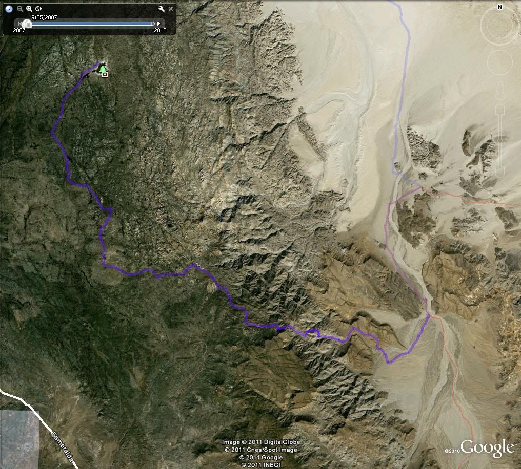
Thanks Neal, Dave:
I'll compare those GPS values to what I've extracted from GE. Attached (I hope) is an image of the planned route.
Thanks again for your input -I'll post a report on current conditions.
[img]http://s1206.photobucket.com/albums/bb450/yukonrob/?action=view¤t=saladatohanson.jpg[/img]
Well clearly there was an operator head-space and timing problem with attaching the image. Hope those interested can make it work.
[Edited on 9-7-2011 by yukonrob]
|
|
|
David K
Honored Nomad
Posts: 65591
Registered: 8-30-2002
Location: San Diego County
Member Is Offline
Mood: Have Baja Fever
|
|
| Quote: | Originally posted by yukonrob
Thanks Neal, Dave:
I'll compare those GPS values to what I've extracted from GE. Attached (I hope) is an image of the planned route.
Thanks again for your input -I'll post a report on current conditions.
[img]http://s1206.photobucket.com/albums/bb450/yukonrob/?action=view¤t=saladatohanson.jpg[/img]
Well clearly there was an operator head-space and timing problem with attaching the image. Hope those interested can make it work.
[Edited on 9-7-2011 by yukonrob] |
|
|
|
yukonrob
Newbie
Posts: 8
Registered: 2-23-2011
Member Is Offline
|
|
Thanks for fixing it. Suppose I ought to learn how to do it correctly.
Again, thanks.
|
|
|
David K
Honored Nomad
Posts: 65591
Registered: 8-30-2002
Location: San Diego County
Member Is Offline
Mood: Have Baja Fever
|
|
On photobucket, under each image in your album is a list of links for various places... for forum posting use the bottom one with [IMG] at the start
and just paste that link directly onto the Nomad page... do not use the Nomad image link icon, not needed.
|
|
|
Neal Johns
Super Nomad
Posts: 1687
Registered: 10-31-2002
Location: Lytle Creek, CA
Member Is Offline
Mood: In love!
|
|
Looks like the route!
Neal
My motto:
Never let a Dragon pass by without pulling its tail!
|
|
|
yukonrob
Newbie
Posts: 8
Registered: 2-23-2011
Member Is Offline
|
|
Thanks for the tutelage on posting the images Dave.
And thanks, Neal, for confirming that I am not horrbly off track - there is quite a spaghetti bowl of trails in some of those areas and google earth
is clearly no substitute for wheels on the ground knowledge.
|
|
|
Neal Johns
Super Nomad
Posts: 1687
Registered: 10-31-2002
Location: Lytle Creek, CA
Member Is Offline
Mood: In love!
|
|
On second look, there is no need for the sideways "V" pointed right on the way down to the La Mano turnoff. The road goes straight south across the
wide mouth of the "V".
My motto:
Never let a Dragon pass by without pulling its tail!
|
|
|
yukonrob
Newbie
Posts: 8
Registered: 2-23-2011
Member Is Offline
|
|
| Quote: | Originally posted by Neal Johns
On second look, there is no need for the sideways "V" pointed right on the way down to the La Mano turnoff. The road goes straight south across the
wide mouth of the "V". |
Ah, yup, I see it now, thanks. Not sure how I missed it the first time - too high or bad rotation or something.
|
|
|
Barry A.
Select Nomad
Posts: 10007
Registered: 11-30-2003
Location: Redding, Northern CA
Member Is Offline
Mood: optimistic
|
|
That trip is something I always wanted to do, but never got-er-done. We have camped and explored all around that area many times back in the '70's
and 80's, and even a few times back in the '60's, but never in 4x4's and were afraid to attempt it in our 2-wheel drive pickups tho we were vaguely
aware of it, as I remember.
What great and wild country that all is. Have a great time seeing more of it, Cat.
Barry
|
|
|
Barry A.
Select Nomad
Posts: 10007
Registered: 11-30-2003
Location: Redding, Northern CA
Member Is Offline
Mood: optimistic
|
|
Opinions please-----------would the trip down to the desert from Luguna Hansen be more pleasant than the other way around??? All the folks I have
heard from have gone the other way, low desert to high mountains.
What say you wise guys?? (and could you ever even find the right road from the "top"??) Which way is easier on your vehicle?
Barry
|
|
|
David K
Honored Nomad
Posts: 65591
Registered: 8-30-2002
Location: San Diego County
Member Is Offline
Mood: Have Baja Fever
|
|
| Quote: | Originally posted by Barry A.
Opinions please-----------would the trip down to the desert from Luguna Hansen be more pleasant than the other way around??? All the folks I have
heard from have gone the other way, low desert to high mountains.
What say you wise guys?? (and could you ever even find the right road from the "top"??) Which way is easier on your vehicle?
Barry |
Barry, my son Chris and I went from the top down... It was in June the day of the Baja 500, and it was a nice, but a LONG days' drive from where we
were watching the race (near Hwy. 3/ Agua Blanca area).
The high point was over 5,000 feet up and big pine trees... and the long down grade was well engineered and not some ranch road. The surface is very
rough from the canyon mouth (El Mano Ranch) to the desert floor, south of Cohabuzo Jcn. It is muy fast from that point north all the way to Guadalupe
Canyon and on to Hwy. 2, however.
Chris emptied the camera taking photos of the racers, so no pics of the road and super views coming down! See http://vivabaja.com/500 for that day's photos! 
|
|
|
| Pages:
1
2 |


