| Pages:
1
2 |
philodog
Nomad

Posts: 168
Registered: 10-9-2010
Member Is Offline
|
|
Fastest way to L Chapala from Calexico?
If I started in Calexico would it be a faster drive time to go south on the Gulf side thru Puertocitos or to go west on I-8, and cross at Tecate or
TJ? And where in Mexicali do you get your FMM? I tried searching the archives with no luck. Thanks!
|
|
|
redhilltown
Super Nomad
Posts: 1130
Registered: 1-24-2009
Location: Long Beach, CA
Member Is Offline
|
|
Wow...kind of a loaded question! Are you actually going TO Chapala? That would be fine but most people pass THROUGH it going somewhere else. And
where that somewhere else is might dictate the responses. If you don't have an suv, truck, or something sturdy even with the new road you don't want
to go the Puertecitos route as there is still a chunk of somewhat nasty dirt road past five islands all the way out. I would personally for SURE go
that way with the right vehicle.
Last time I got my tourist card at Mexicali the office was on the left as you drove in and you park on the right.
|
|
|
David K
Honored Nomad
Posts: 65591
Registered: 8-30-2002
Location: San Diego County
Member Is Offline
Mood: Have Baja Fever
|
|
The San Felipe to Puertecitos 52 mile highway is not for high speed because of many short, steep dips, poorly marked that will keep you under 50
mph...
The newest section from Puertecitos towards Gonzaga is a high speed highway... until pavement ends in about 32 miles... You have about 50 dirt miles
to Laguna Chapala on Hwy. 1.
If you need all paved (with dirt detours for construction), then cross at Tecate and take the Ensenada highway.
|
|
|
durrelllrobert
Elite Nomad
Posts: 7393
Registered: 11-22-2007
Location: Punta Banda BC
Member Is Offline
Mood: thriving in Baja
|
|
Fastest way to L Chapala
are you talking about Laguna de Chapala in Jalisco?
Bob Durrell
|
|
|
David K
Honored Nomad
Posts: 65591
Registered: 8-30-2002
Location: San Diego County
Member Is Offline
Mood: Have Baja Fever
|
|
| Quote: | Originally posted by durrelllrobert
Fastest way to L Chapala
are you talking about Laguna de Chapala in Jalisco?
| Quote: | Originally posted by philodog
If I started in Calexico would it be a faster drive time to go south on the Gulf side thru Puertocitos or to go west on I-8, and cross at Tecate or
TJ? And where in Mexicali do you get your FMM? I tried searching the archives with no luck. Thanks! |
|
Don't think he is Bob...?
|
|
|
durrelllrobert
Elite Nomad
Posts: 7393
Registered: 11-22-2007
Location: Punta Banda BC
Member Is Offline
Mood: thriving in Baja
|
|
| Quote: | Originally posted by David K
| Quote: | Originally posted by durrelllrobert
Fastest way to L Chapala
are you talking about Laguna de Chapala in Jalisco?
| Quote: | Originally posted by philodog
If I started in Calexico would it be a faster drive time to go south on the Gulf side thru Puertocitos or to go west on I-8, and cross at Tecate or
TJ? And where in Mexicali do you get your FMM? I tried searching the archives with no luck. Thanks! |
|
Don't think he is Bob...? |
Sorry, I just had no idea that there was also one in Baja
Bob Durrell
|
|
|
David K
Honored Nomad
Posts: 65591
Registered: 8-30-2002
Location: San Diego County
Member Is Offline
Mood: Have Baja Fever
|
|
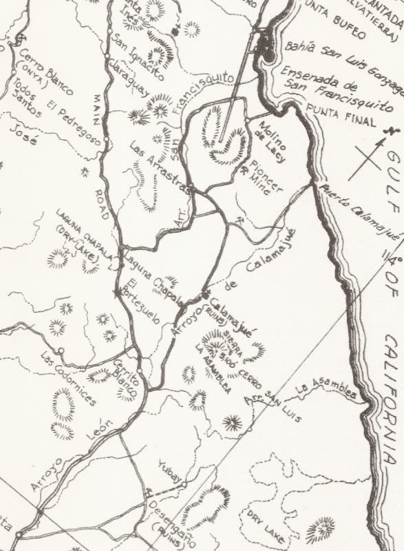
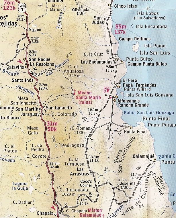
Laguna Chapala is a pretty famous Baja location... In the old days, the deep silt dust beds were perhaps the worst part of the drive to La Paz,
followed by the high speed dry lake bed to blow some dust off. Mama Espinoza's brother Arturo owned Rancho Chapala... as well as many mine claims in
the region.
On maps...
[Edited on 12-30-2011 by David K]
|
|
|
redhilltown
Super Nomad
Posts: 1130
Registered: 1-24-2009
Location: Long Beach, CA
Member Is Offline
|
|
Very interesting DK! About 15 years ago my buddy and I were coming out from Gonzaga and got a flat on the notorious "sharp rock" section. I had the
spare of course but I HATE to drive in Baja very long without fixing it. We came up the house at Laguna Chapala in the dark of night (after the old
military check point stop) and softly called out if anyone was around to possibly help fix a flat. Sure enough, the lights popped on, the compressor
cranked up and a very nice guy and his son fixed it for $5.00. We of course gave him $10.00 which he balked at. It was good ol Mexican hospitality at
its best.
|
|
|
goldhuntress
Senior Nomad
Posts: 663
Registered: 1-28-2010
Member Is Offline
|
|
Once we stopped and parked off the road and walked down to the "dry" lake bed to check it out and I found an arrowhead! I've also gone out there and
looked for meteorites but didn't find one. 
|
|
|
durrelllrobert
Elite Nomad
Posts: 7393
Registered: 11-22-2007
Location: Punta Banda BC
Member Is Offline
Mood: thriving in Baja
|
|
| Quote: | Originally posted by David K
Laguna Chapala is a pretty famous Baja location... In the old days, the deep silt dust beds were perhaps the worst part of the drive to La Paz,
followed by the high speed dry lake bed to blow some dust off. Mama Espinoza's brother Arturo owned Rancho Chapala... as well as many mine claims in
the region.
On maps...
[Edited on 12-30-2011 by David K] |
Oh, it's not a lake. I've been past it many times and didn't realize it
was LAGUNA Chapala..
Bob Durrell
|
|
|
Sandlefoot
Nomad
Posts: 220
Registered: 10-31-2011
Location: La Paz
Member Is Offline
Mood: Home
|
|
FYI
The 52 miles past San Felipe is not a fast road, if you want to live!!! There are several Vado's that are very sharp, drop fast going in and a sharp
angle coming out that will launch you if you are not paying attention. If you do not know the road, 55 to 60 and be very ready to hit the brakes if
one of these pops up. There is one stretch about 3 miles north of Puertecitos that there are five of these.
Now the 15 miles of new road on south of Puetrecitos is a very well built road and flat surface, wide nice piece of road. The only problem is they
made the cuts very steep, and there are rocks down on the road in the cuts. They other day when we came through there were rocks that were difficult
to see, although they were large enough to hurt, because they were in the shadows of the cut. Just pay attention and you will do fine!!!!
|
|
|
tripledigitken
Ultra Nomad
Posts: 4848
Registered: 9-27-2006
Member Is Offline
|
|
Originally posted by durrelllrobert
Oh, it's not a lake. I've been past it many times and didn't realize it was LAGUNA Chapala..
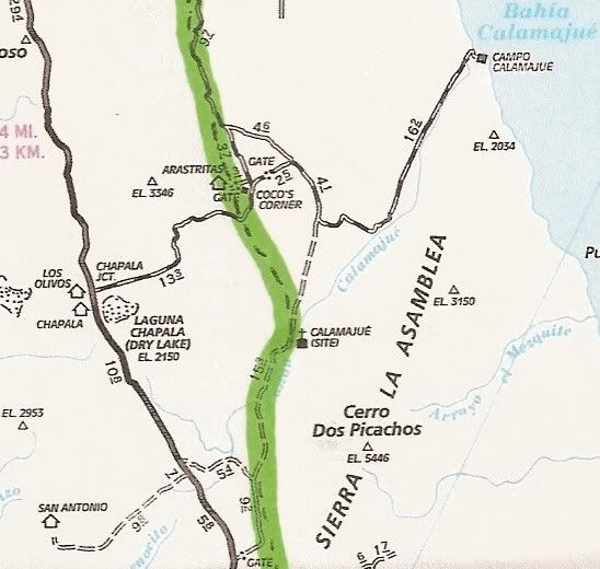
In a wet year it looks like this.................2/10

|
|
|
David K
Honored Nomad
Posts: 65591
Registered: 8-30-2002
Location: San Diego County
Member Is Offline
Mood: Have Baja Fever
|
|
Yup, for a lake to be dry, it first needs to be wet!
In Baja, 'Laguna' is used both for lagoon and for 'seasonal' lakes that are often dry or just muddy (Laguna Hanson, Laguna Salada, Laguna Chapala...
Photos taken May, 2010 by BajaTripper at Laguna Chapala:
|
|
|
philodog
Nomad
Posts: 168
Registered: 10-9-2010
Member Is Offline
|
|
Why Laguna Chapala? I thought it might be a nice place for a family vacation. Rent a lakeside home, kids can play on the beach all day, a little bass
fishing from the dock. I`m sure there`s a decent golf course nearby. Anybody got a recommendation for a good vacation rental agency?
|
|
|
David K
Honored Nomad
Posts: 65591
Registered: 8-30-2002
Location: San Diego County
Member Is Offline
Mood: Have Baja Fever
|
|
| Quote: | Originally posted by philodog
Why Laguna Chapala? I thought it might be a nice place for a family vacation. Rent a lakeside home, kids can play on the beach all day, a little bass
fishing from the dock. I`m sure there`s a decent golf course nearby. Anybody got a recommendation for a good vacation rental agency?
|
 You'll fit right in here, welcome! You'll fit right in here, welcome!
|
|
|
philodog
Nomad
Posts: 168
Registered: 10-9-2010
Member Is Offline
|
|
Just kidding! Laguna Chapala obviously because it`s where both routes meet. I`ll rephrase the question to get rid of any ambiguity: Say two
experienced Baja explorers left Calexico at the same time in identical 4x4 pickups. One crosses at Mexicali and follows the Gulf route, the other goes
west on I-8 and crosses at Tecate and takes the coast route. Barring any breakdowns or unusual delays which person will reach Laguna Chapala first
assuming both drive at prudent speeds for the prevailing conditions?
I did the Gulf route 20 years ago, definitely not a shortcut then but was wondering if the new pavement has evened things up.
|
|
|
David K
Honored Nomad
Posts: 65591
Registered: 8-30-2002
Location: San Diego County
Member Is Offline
Mood: Have Baja Fever
|
|
In 4x4 trucks (4WD not needed)... now, I would go the Gulf route... much shorter distance, less city hassles (no Ensenada or San Quintin valley
traffic delays). If you have a trailer or a street only vehicle, then continue to Hwy. 1 via Tecate and Hwy. 3.
|
|
|
philodog
Nomad
Posts: 168
Registered: 10-9-2010
Member Is Offline
|
|
Thanks, that was the kind of answer I was looking for.
|
|
|
David K
Honored Nomad
Posts: 65591
Registered: 8-30-2002
Location: San Diego County
Member Is Offline
Mood: Have Baja Fever
|
|
| Quote: | Originally posted by philodog
Thanks, that was the kind of answer I was looking for. |
Just take it easy... no Baja 1000 stuff on the graded/ washboard road... 50 miles can be done in ~2 hours safely... 3 with stops like at Coco's
Corner. Maybe drop tire pressure to 25 psi... less rough/ less punctures if rubber can give a bit!
|
|
|
David K
Honored Nomad
Posts: 65591
Registered: 8-30-2002
Location: San Diego County
Member Is Offline
Mood: Have Baja Fever
|
|
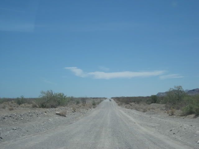
Some road photos:
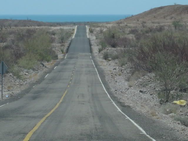
Old style highway San Felipe to Puertecitos
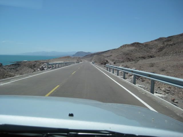
New, high speed highway, south of Puertecitos
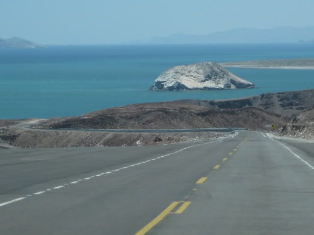
Nearing El Huerfanito
Regraded road along new road construction.
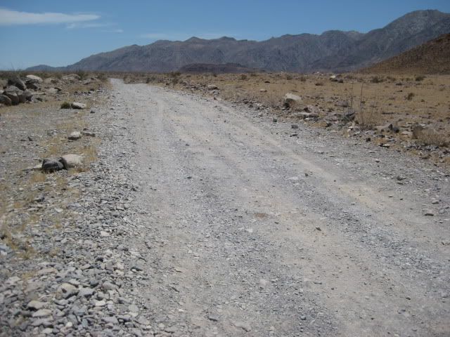
North of Gonzaga, 2010
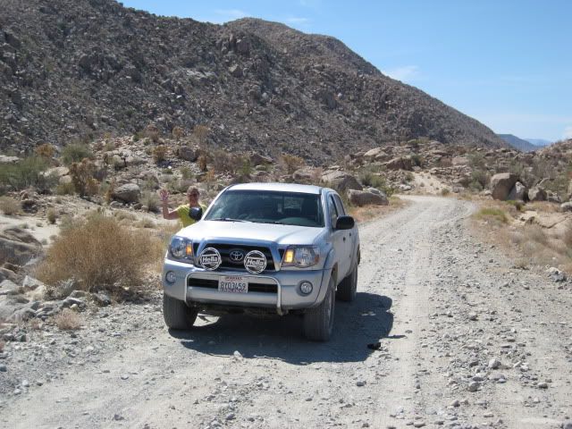
Gonzaga to Coco's

Coco's Corner
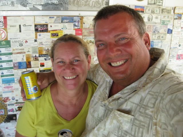
Great place to stop for a Pacifico!
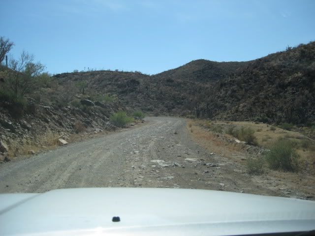
Coco's to Chapala
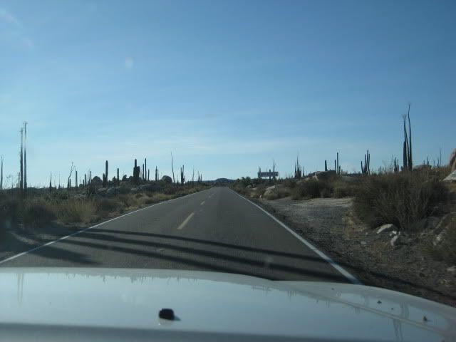
Hwy. 1 near Cataviña
|
|
|
| Pages:
1
2 |