| Pages:
1
2
3 |
Sprocket
Junior Nomad

Posts: 67
Registered: 1-3-2012
Member Is Offline
|
|
Headed down to see the whales got some ?s
I plan to stay at Jardines (san quintin) on the first night. Then load up the wife and kids and head to GN. I would like to stop at the rock art at
Catavina, Marmol, and Mision San Borja. Heres my problem
1) last time I stopped at the rock art sign I couldnt find anything (I was coming back from the baja 1000 in a rush so gave up)
2) on our last try for San Borja I got lost, tried to access via BOLA highway.
Does any one have gps cords?Catavina, Marmol, and Mision San Borja
Can I get to San Borja off the 1 easily?
Anything else we can stop and see easily from the freeway on our way? recommendations
I will be going back thru Cocos to San Felipe.
Will Be driving our 15 pass e350 lifted dont mind off roading just cant deal with getting stuck with the family.
children are 5 and 8 (pretty industrial units)
thanks
[Edited on 2-23-2012 by Sprocket]
|
|
|
BajaRat
Super Nomad
Posts: 1304
Registered: 3-2-2010
Location: SW Four Corners / Bahia Asuncion BCS
Member Is Offline
Mood: Ready for some salt water with my Tecate
|
|
Marmol info.
Just got back, road has just been graded and is in excellent condition. School house approx. 15 km in complete with km markers, mine approx 15 km
further and well marked.
Caution!!!!!!!!!!!! mining has begun again, large dump trucks using road. Dump driver told us they have a market in China for the material.
Have fun! Rat
|
|
|
larryC
Super Nomad
Posts: 1499
Registered: 8-11-2008
Location: BoLA
Member Is Offline
|
|
From Hiway 1 you can get to San Borja through Rosarito, not sure of the KM mark but probably 40 or 50 klicks south of Punta Prieta. The road to Borja
through Roasrito is pretty well marked, and the road is better than the road off the LA bay road.
Hth
Larry
|
|
|
David K
Honored Nomad
Posts: 65591
Registered: 8-30-2002
Location: San Diego County
Member Is Offline
Mood: Have Baja Fever
|
|
| Quote: | Originally posted by Sprocket
I plan to stay at Jardines (san quintin) on the first night. Then load up the wife and kids and head to GN. I would like to stop at the rock art at
Catavina, Marmol, and Mision San Borja. Heres my problem
1) last time I stopped at the rock art sign I couldnt find anything (I was coming back from the baja 1000 in a rush so gave up)
2) on our last try for San Borja I got lost, tried to access via BOLA highway.
Does any one have gps cords?Catavina, Marmol, and Mision San Borja
Can I get to San Borja off the 1 easily?
Anything else we can stop and see easily from the freeway on our way? recommendations
I will be going back thru Cocos to San Felipe.
Will Be driving our 15 pass e350 lifted dont mind off roading just cant deal with getting stuck with the family.
children are 5 and 8 (pretty industrial units)
thanks |
I have ALL that information for you... anytime, just go to http://vivabaja.com there is a GPS waypoint section as well as photos from my trips to those sites. A fast way to find the trip pages (which
usually have GPS and road directions) is to use this index to find the photos of a site: http://vivabaja.com/tours (you will note that link is in each of my Nomad posts, below).
At this time (2:25 pm PST) my server is down while Edison replaces a transformer... so the links will be back up later... I will post them to further
assist your quest.
The Cataviña rock art sign you will note is at the top of the boulder hill, across the arroyo from Hwy. 1 (Km. 176)... just north of the north arroyo
crossing. That is where the cave art is located... at the top, under the big boulder... Drive down off Hwy. 1, park in the arroyo, and climb up to the
top... have a look inside.
Here is the base of the hill the rock art is on top of:

Some more photos inside the cave: http://vivabaja.com/703/page5.html
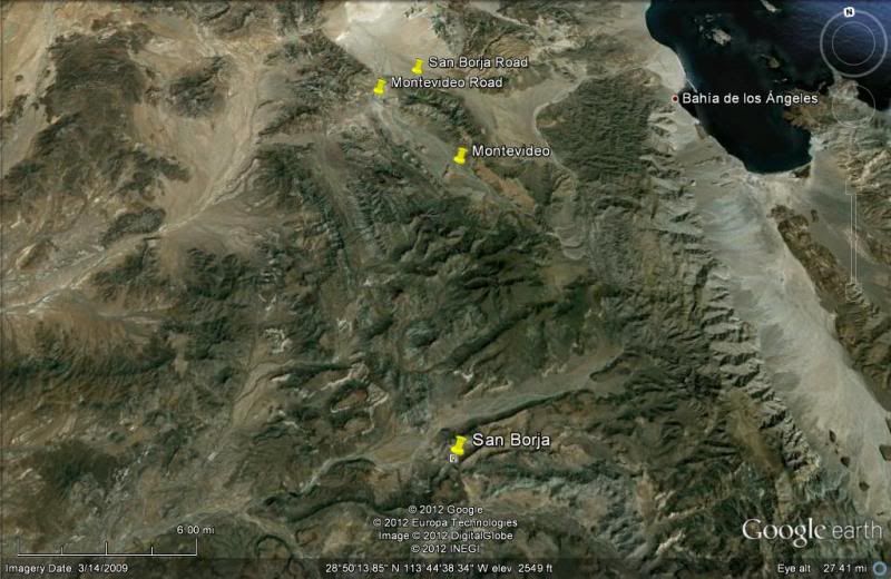
The Road to San Borja (22 miles) from the L.A. Bay Hwy. is signed at the turnoff (near the dry lake bed)... and it is basically just one graded road
all the way there. You can't miss the mission... it is very impressive... the furthest north stone mission in California (Baja)... Construction was
done by the Dominicans and work stopped in 1801. Only the bell tower was left out. Another road in (or a loop route out) is from Hwy. 1 at Rosarito...
also about 22 miles away. It is a bit slower and rougher than the L.A. Bay Hwy. route in... on our last visit 2 years ago.
See both routes to San Borja and the mission on our last trip there in 2009: http://vivabaja.com/709/page16.html
Here is the good road between the mission and the L.A. Bay highway:

Many many sites along Hwy. 1 and it all depends on your time, vehicle, and interests... mines, petroglyphs, fossils, missions! Baja is an awesome
place!!
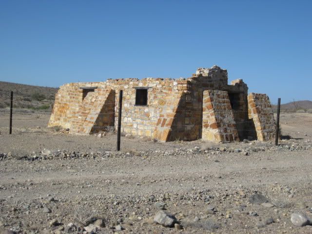
La Lobera, Las Pintas, Sauzalito, San Fernando, El Marmol, Montevideo, all accessible with 2WD...
[Edited on 1-18-2012 by David K]
|
|
|
David K
Honored Nomad
Posts: 65591
Registered: 8-30-2002
Location: San Diego County
Member Is Offline
Mood: Have Baja Fever
|
|
| Quote: | Originally posted by larryC
From Hiway 1 you can get to San Borja through Rosarito, not sure of the KM mark but probably 40 or 50 klicks south of Punta Prieta. The road to Borja
through Roasrito is pretty well marked, and the road is better than the road off the LA bay road.
Hth
Larry |
KM. 52... from TW on the KM. Marker thread (I just bumped up)
KM14 Punta Prieta
KM39 Hwy to Santa Rosalillita
KM52 Rosarito and access to Mission San Borja
KM62/63 Access to Pacific Ocean by Altamira (AB)
KM67/68 Access to El Tomatal and Miller's Landing
KM70 Access east to El Marmolito Onyx mine
KM96 Jesus Maria
|
|
|
David K
Honored Nomad
Posts: 65591
Registered: 8-30-2002
Location: San Diego County
Member Is Offline
Mood: Have Baja Fever
|
|
EL MARMOL (from my Mar. 2011 post):
The 56 mile drive down Highway One to the El Marmol road (from El Rosario) was a breeze and the signed road was between the 148 and 149 kilometer
markers. The next 9 miles to El Marmol are dirt, but some of the easiest dirt miles in Baja and would be a breeze for most vehicles.
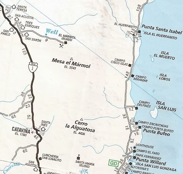
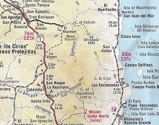
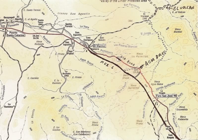
Of course... even more interesting than El Marmol, is the rare cold water geyser and soda springs of El Volcan, just 4 miles and a short 1/4 mile hike
away!
SEE EL VOLCAN here: http://forums.bajanomad.com/viewthread.php?tid=52804
[Edited on 1-17-2012 by David K]
|
|
|
David K
Honored Nomad
Posts: 65591
Registered: 8-30-2002
Location: San Diego County
Member Is Offline
Mood: Have Baja Fever
|
|
| Quote: | Originally posted by BajaRat
Marmol info.
Just got back, road has just been graded and is in excellent condition. School house approx. 15 km in complete with km markers, mine approx 15 km
further and well marked.
Caution!!!!!!!!!!!! mining has begun again, large dump trucks using road. Dump driver told us they have a market in China for the material.
Have fun! Rat |
The mine is La Olvidada, now reached by a good graded road from El Marmol... There they are mining barite used for oil exploration/ drilling... See it
here:
http://forums.bajanomad.com/viewthread.php?tid=52779
|
|
|
Sprocket
Junior Nomad
Posts: 67
Registered: 1-3-2012
Member Is Offline
|
|
David thanks
1) rock art in cave under big rock. NE of parking lot with whats left of a palapa. is it over the ridge we saw or just right in that area?
2) El Marmol looks like it should be easy with your instructions (is it easy to get to the guadalupe rock shrine from El Marmol rd?
3) San Borja. I checked earth google, Iam now sure we took the first sand wash
after the juction to bola not the rd. a few mile further east. Will 2x4 work to get there on this road. or should we go in off 1.
I was told the the road from Rosarito was better of highway 1. Is this true and if so where would I find the entrance off the 1? How long should I
plan from the time we leave the highway to San Borja?
thanks
[Edited on 1-18-2012 by Sprocket]
[Edited on 1-18-2012 by Sprocket]
|
|
|
David K
Honored Nomad
Posts: 65591
Registered: 8-30-2002
Location: San Diego County
Member Is Offline
Mood: Have Baja Fever
|
|
| Quote: | Originally posted by Sprocket
David thanks
1) rock art in cave under big rock. NE of parking lot with whats left of a palapa. is it over the ridge we saw or just right in that area?
|
Always happy to help others find a Baja adventure!
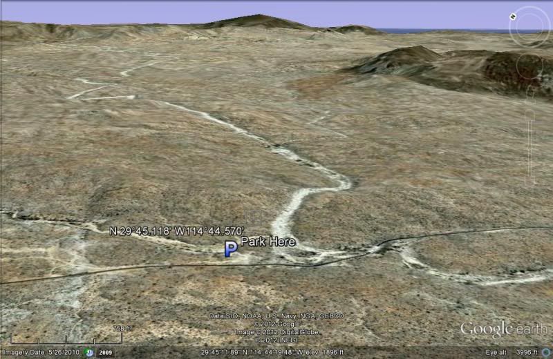
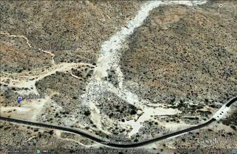
1) rock art in cave under big rock. NE of parking lot with whats left of a palapa. is it over the ridge we saw or just right in that area?:
At about Km. 176, just north of the arroyo crossing, pull off the highway... a palapa used to be there, correct. Park there or go on down to the
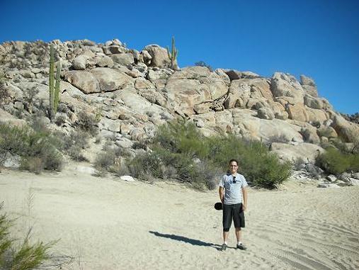
arroyo and park... be careful of sand if you do. Look across the arroyo from the park area and see the boulder hill (in my photo with Josh above). The
sign is on top of that hill, as is the painted cave. The hill is at the junction of the two arroyos (may have water in them). A trail also climbs up
from the south side as well as the west side (pictured).
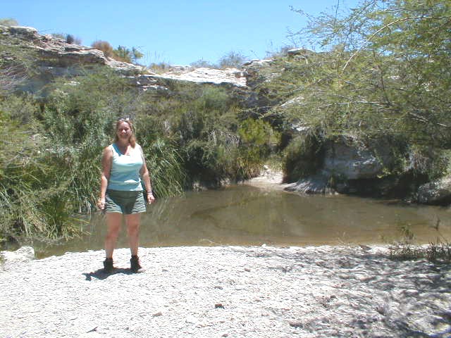
Here's more photos from 2001... that's Amo Pescar with camera in cave:
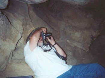
Mike (Amo Pescar) photographs the Catavina rock art found in this cave, on top of a hill just a short distance from Mex.#1. N 29°45.118' W114°44.570'
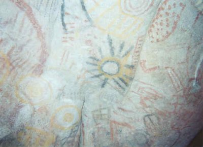
This is just a small sample of the colorful ancient pictographs
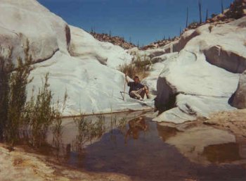
Here's Chrstopher at the ' swimming pool', just north of the painted cave hill. N 29°45.106' W114°44.451'
==============================================
[Edited on 1-18-2012 by David K]
|
|
|
David K
Honored Nomad
Posts: 65591
Registered: 8-30-2002
Location: San Diego County
Member Is Offline
Mood: Have Baja Fever
|
|
| Quote: | Originally posted by Sprocket
David thanks
2) El Marmol looks like it should be easy with your instructions (is it easy to get to the guadalupe rock shrine from El Marmol rd?
thanks
|
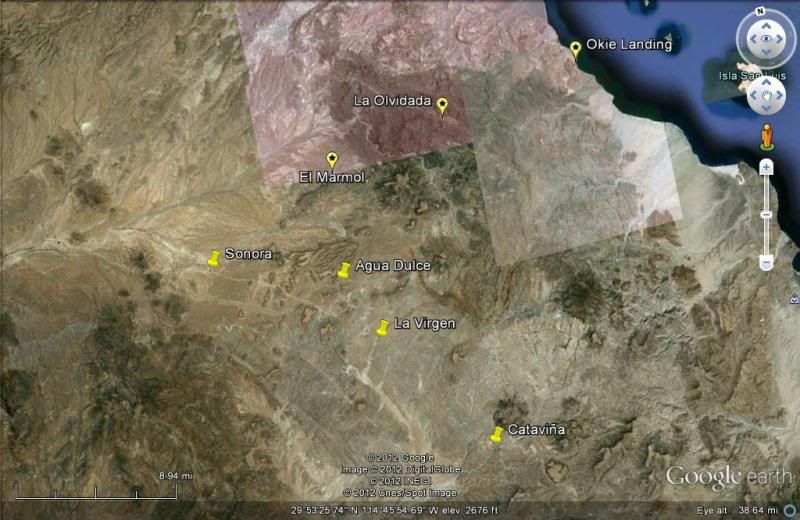
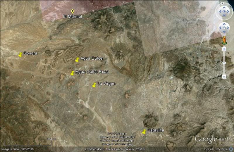
I have no idea what 'guadalupe rock shrine' you are speaking about near El Marmol road???
The El Marmol road goes from near Rancho Sonora (where onyx crafts are sold) past the former San Simon windmill to El Marmol... then continues to
Arroyo El Volcan and ends at mina La Olvidada (with a view down to the islands south of Puertecitos).
|
|
|
David K
Honored Nomad
Posts: 65591
Registered: 8-30-2002
Location: San Diego County
Member Is Offline
Mood: Have Baja Fever
|
|
| Quote: | Originally posted by Sprocket
David thanks
3) San Borja. I checked earth google, Iam now sure we took the first sand wash
after the juction to bola not the rd. a few mile further east. Will 2x4 work to get there on this road. or should we go in off 1.
I was told the the road from Rosarito was better of highway 1. Is this true and if so where would I find the entrance off the 1? How long should I
plan from the time we leave the highway to San Borja?
thanks
|
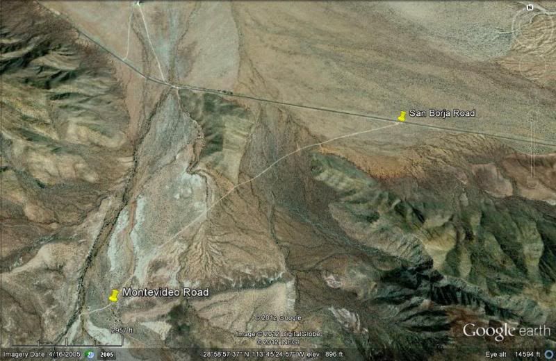
In 2009, the road from the L.A. Bay Highway to San Borja was much better than the road from Rosarito... In 2003, it was the other way around... Things
do change... But, they are both 2WD roads... and not a lot of rocky parts on the L.A. Bay route.
If you go from Rosarito, you leave Hwy. 1 at the big curve where the highway swings from southbound to west bound. Continue south into town on the
dirt road, and soon you will take a road to the left (east)... You will find it or just ask... don't remember seeing any sign... but it is a small
town and only one road leaves to the east and the other to the south over the hill.
The road form the L.A. Bay highway is signed... and is a wide graded road that meets the pavement at an angle heading towards L.A. Bay. 2 miles down
the road is the side road to Montevideo painted cliff (7 miles)... Well worth a visit... 2WD okay as long as you are in a truck or big van. Beautiful
desert in there... the world's tallest boojum trees, too.
[Edited on 1-18-2012 by David K]
|
|
|
Sprocket
Junior Nomad
Posts: 67
Registered: 1-3-2012
Member Is Offline
|
|
I have no idea what 'guadalupe rock shrine' you are speaking about near El Marmol road.
La Virgen??
I have traveled to El Marmol, La Virgen(shrine rock) and a window rock all by dirt bike on single track they all seemed close but we didnt use roads
and you do loose track of time on bikes.
[Edited on 1-18-2012 by Sprocket]
[Edited on 1-18-2012 by Sprocket]

|
|
|
ArvadaGeorge
Nomad
Posts: 358
Registered: 9-2-2003
Member Is Offline
|
|
There is a major shrine on the west side of the road between El Rosario And Marmo Turn . Once you get into the big rocks keep a eye
to the west
|
|
|
David K
Honored Nomad
Posts: 65591
Registered: 8-30-2002
Location: San Diego County
Member Is Offline
Mood: Have Baja Fever
|
|
| Quote: | Originally posted by Sprocket
I have no idea what 'guadalupe rock shrine' you are speaking about near El Marmol road.
La Virgen??
I have traveled to El Marmol, La Virgen(shrine rock) and a window rock all by dirt bike on single track they all seemed close but we didnt use roads
and you do loose track of time on bikes.
[Edited on 1-18-2012 by Sprocket]
[Edited on 1-18-2012 by Sprocket] |
OH, yes... but it has never been refered to as a Guadalupe shrine... but simply as La Virgen.... Thanks for clearing that up.
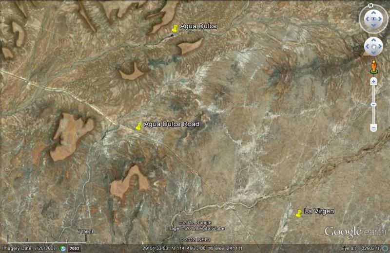
La Virgen is on the old main road, between the El Marmol road and Cataviña. If you visit historic Agua Dulce, then continue south on the old road to
La Virgen, and then you can return to Hwy. 1 or just continue south on the old Baja 1000 road, which rejoins Hwy. 1 right by the Painted Cave parking
area.

La Virgen
AGUA DULCE : 29º52.97', 114º49.38'(NAD27)
Elizabeth at Agua Dulce... Turn north from Hwy. 1 between
Km. 160-161 (29º51.56', 114º50.35'). Go 1.4 mi. to old Baja main road , turn left for 0.3 mi. then right 0.3 more. Hike into gully.
|
|
|
David K
Honored Nomad
Posts: 65591
Registered: 8-30-2002
Location: San Diego County
Member Is Offline
Mood: Have Baja Fever
|
|
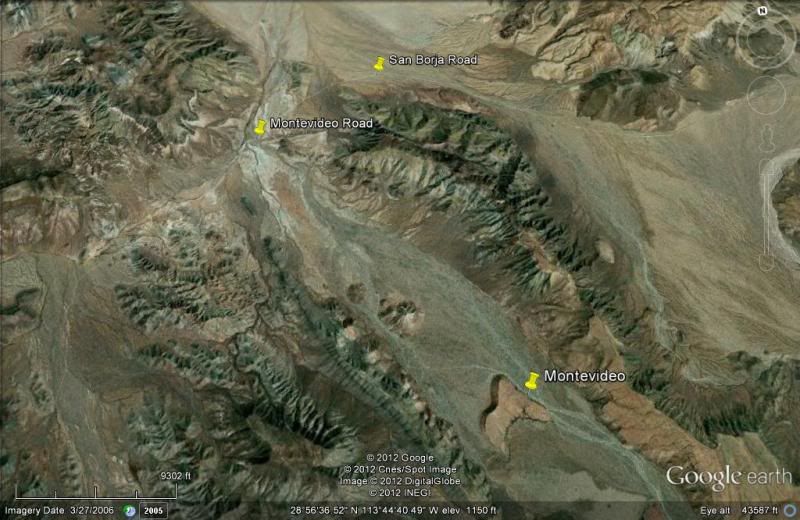
From Space!
|
|
|
Bajatripper
Ultra Nomad
Posts: 3152
Registered: 3-20-2010
Member Is Offline
|
|
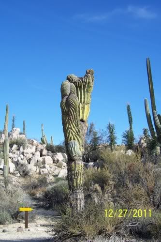
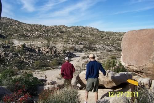
On the Cataviña rock art (I seem to recall reading it's informal name is the nursery), you won't have any problem finding it this time down.
They are developing it into a small tourist trap, with a very clearly-marked trail up, going around the left side instead of what always seemed the
natural way up, head-on. From the looks of it, I think I was the second person to use one of the two new primitive-style toilets. There's a new
parking area and now they make you walk along a trail down the arroyo and up to the cave. I seldom use "you can't miss it" because it usually means
you will, but I'd use it in this context.
David, nice pics on the old Virgencita, something only a true "old road buff" would know about. It is one of my favorite spots to take newbies to. I
remember the old man who lived there in the 1960s, getting by on selling machaca, coffee and gasoline. I remember something about a fire, but can't
quite recall what. Perhaps your family was through the area then and you remember something.
New trail marker leading the way up the hill, past the weird cardon.
View from the top, heading back. Those new markers remind me of DavidK's map posts.
[Edited on 1-19-2012 by Bajatripper]
There most certainly is but one side to every story: the TRUTH. Variations of it are nothing but lies.
|
|
|
Bajatripper
Ultra Nomad
Posts: 3152
Registered: 3-20-2010
Member Is Offline
|
|
Some advice on whale-watching at San Ignacio Lagoon, should you make it there. If you approach the camps from the north, the price gets cheaper the
further south you get. Last year, we ended up at Campo Cortez, which is the last camp reachable by road (there are some further south, but you have to
contract through a tour company to reach them by boat).
A side benefit of going further south is that the whale-watching area is closer-by, so the boat ride isn't very long. That can make a BIG difference
on windy, choppy days. The camps reached by boats are near enough to the action to see whales from the comfort of folding chairs set up along the
shoreline.
Campo Cortez, from the boat
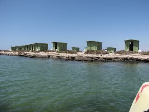
One of several temporary camps where boat tourists get to watch whales from the shore
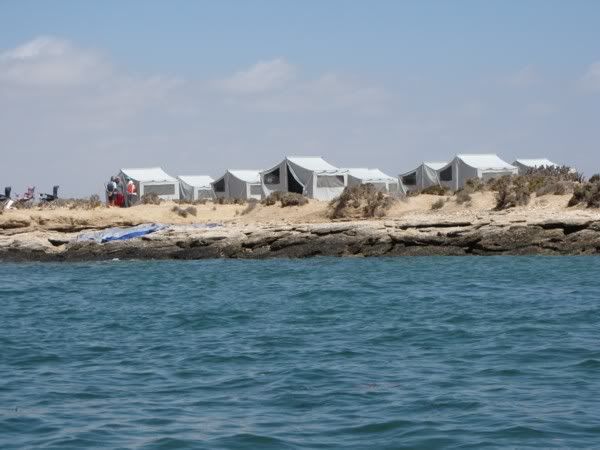
[Edited on 1-19-2012 by Bajatripper]
There most certainly is but one side to every story: the TRUTH. Variations of it are nothing but lies.
|
|
|
Islandbuilder
Senior Nomad
Posts: 555
Registered: 11-9-2011
Location: nob
Member Is Offline
Mood: bewildered
|
|
| Quote: | Originally posted by Bajatripper
Some advice on whale-watching at San Ignacio Lagoon, should you make it there. If you approach the camps from the north, the price gets cheaper the
further south you get. Last year, we ended up at Campo Cortez, which is the last camp reachable by road (there are some further south, but you have to
contract through a tour company to reach them by boat).
A side benefit of going further south is that the whale-watching area is closer-by, so the boat ride isn't very long. That can make a BIG difference
on windy, choppy days. The camps reached by boats are near enough to the action to see whales from the comfort of folding chairs set up along the
shoreline.
Campo Cortez, from the boat
One of several temporary camps where boat tourists get to watch whales from the shore
[Edited on 1-19-2012 by Bajatripper] |
Great info, BT.
Can you just drive up to those camps and hire a panga, or do you need to make prior arrangements?
Thanks.
|
|
|
woody with a view
PITA Nomad
Posts: 15940
Registered: 11-8-2004
Location: Looking at the Coronado Islands
Member Is Offline
Mood: Everchangin'
|
|
drive right up, as far as the road goes.
|
|
|
Islandbuilder
Senior Nomad
Posts: 555
Registered: 11-9-2011
Location: nob
Member Is Offline
Mood: bewildered
|
|
Thanks Woody!
|
|
|
| Pages:
1
2
3 |


