| Pages:
1
2
3
4 |
BajaWarrior
Super Nomad

Posts: 2307
Registered: 9-27-2006
Location: Mission Bay, San Diego. Playa Hermosa, San Felipe.
Member Is Offline
Mood: Anxious to get south
|
|
Larry, we're going to need a barge type vessel pulled by your aluminum boat to deliver ATV's to the Canyon!
We're ready!

Or perhaps pulled by Seadoos?

Haven't had a bad trip yet....
|
|
|
Bug
Junior Nomad
Posts: 62
Registered: 11-12-2005
Location: San Felipe, Baja
Member Is Offline
Mood: Life can not get better than this!
|
|
Larry,,,
Thanks for the pictures there wonderful.. I will put this on my bucket list to do..
one day..
|
|
|
David K
Honored Nomad
Posts: 65559
Registered: 8-30-2002
Location: San Diego County
Member Is Offline
Mood: Have Baja Fever
|
|
Beautiful canyon... no wonder Erle Stanley Gardner tried so hard to get in there!
The prospector's pick story is a classic, too! (be careful of Red Diamondbacks!)
|
|
|
Mexitron
Ultra Nomad
Posts: 3397
Registered: 9-21-2003
Location: Fort Worth, Texas
Member Is Offline
Mood: Happy!
|
|
Awesome trip! That's the stuff I love doing, looks like a beautiful canyon. Thanks for posting.
BTW those look like Washingtonia robusta---Mexican Fan Palms---which oddly enough aren't too common in the wilds...
|
|
|
David K
Honored Nomad
Posts: 65559
Registered: 8-30-2002
Location: San Diego County
Member Is Offline
Mood: Have Baja Fever
|
|
| Quote: | Originally posted by Mexitron
Awesome trip! That's the stuff I love doing, looks like a beautiful canyon. Thanks for posting.
BTW those look like Washingtonia robusta---Mexican Fan Palms---which oddly enough aren't too common in the wilds... |
Looks like it might be their point of origin?
|
|
|
BAJACAT
Ultra Nomad
Posts: 2902
Registered: 11-21-2005
Location: NATIONAL CITY, CA
Member Is Offline
|
|
So manny canyons, so little time," watch out for RED DIAMOND BACKS".
nice trip report...
|
|
|
wilderone
Ultra Nomad
Posts: 3907
Registered: 2-9-2004
Member Is Offline
|
|
Great report - great photos. Where are the water sources? Do you think any are permanent?
|
|
|
Neal Johns
Super Nomad
Posts: 1687
Registered: 10-31-2002
Location: Lytle Creek, CA
Member Is Offline
Mood: In love!
|
|
One of the best, if not the best, trip reports and photos I have ever seen. Wow!
Neal Johns - Wish I were 60 years younger. 
My motto:
Never let a Dragon pass by without pulling its tail!
|
|
|
Santiago
Ultra Nomad
Posts: 3544
Registered: 8-27-2003
Member Is Offline
|
|
| Quote: | Originally posted by Neal Johns
Neal Johns - Wish I were 60 years younger. |
That's odd - exactly what the various WIW say.
|
|
|
David K
Honored Nomad
Posts: 65559
Registered: 8-30-2002
Location: San Diego County
Member Is Offline
Mood: Have Baja Fever
|
|
| Quote: | Originally posted by Santiago
| Quote: | Originally posted by Neal Johns
Neal Johns - Wish I were 60 years younger. |
That's odd - exactly what the various WIW say. |
That's low Santiago!
|
|
|
Neal Johns
Super Nomad
Posts: 1687
Registered: 10-31-2002
Location: Lytle Creek, CA
Member Is Offline
Mood: In love!
|
|
Santiago,
The next time my covered wagon heads your way, watch out! 
My motto:
Never let a Dragon pass by without pulling its tail!
|
|
|
Barry A.
Select Nomad
Posts: 10007
Registered: 11-30-2003
Location: Redding, Northern CA
Member Is Offline
Mood: optimistic
|
|
LarryC (or anybody that can help)----
Did you get GPS coordinates of the exact location of the "cliff" (dry waterfall) in your photo----the one that Gardner and crew lowered their Pac-Jacs
over?
----or even better, a "stick pin" in the Google earth view of the
dry waterfall location?
(I think I need to buy a couple of ROKON's)
barry
|
|
|
larryC
Super Nomad
Posts: 1499
Registered: 8-11-2008
Location: BoLA
Member Is Offline
|
|
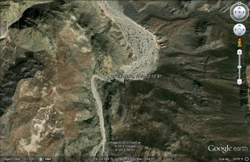
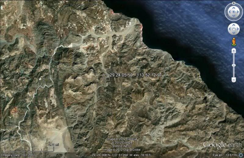
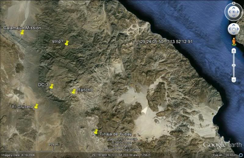
Barry
The GE coordinates are N 29 24'05.50 and W 113 52'12.91. It is in La Botica wash 5 or 6 miles from the coast. If you go in by boat you do not need to
lower the bikes over the cliff. If you go in from above as ESG did then you will have negotiate that drop off one way or the other. If you follow
Botica wash up to the dry lake and look in a northerly direction you will see Salsipudes canyon. I think if you were able to get to that dry lake
somehow you could find a way into the canyon without going through La Botica. Be fun hunting for that path. Maybe through Mesa Yubay and down the
wash.
Larry
Larry
|
|
|
David K
Honored Nomad
Posts: 65559
Registered: 8-30-2002
Location: San Diego County
Member Is Offline
Mood: Have Baja Fever
|
|
| Quote: | Originally posted by Barry A.
LarryC (or anybody that can help)----
Did you get GPS coordinates of the exact location of the "cliff" (dry waterfall) in your photo----the one that Gardner and crew lowered their Pac-Jacs
over?
----or even better, a "stick pin" in the Google earth view of the
dry waterfall location?
(I think I need to buy a couple of ROKON's)
barry |
Baja Nomad 'BillB' has a Rokon just for getting into Salsipuedes from the dry lake bed...
|
|
|
larryC
Super Nomad
Posts: 1499
Registered: 8-11-2008
Location: BoLA
Member Is Offline
|
|
But has he figured out how to get the rokon to the dry lake bed?
|
|
|
larryC
Super Nomad
Posts: 1499
Registered: 8-11-2008
Location: BoLA
Member Is Offline
|
|
And David, can you tell me how to post a GE shot on here. You do it all the time and I can't figure it out.
|
|
|
David K
Honored Nomad
Posts: 65559
Registered: 8-30-2002
Location: San Diego County
Member Is Offline
Mood: Have Baja Fever
|
|
| Quote: | Originally posted by Barry A.
LarryC (or anybody that can help)----
Did you get GPS coordinates of the exact location of the "cliff" (dry waterfall) in your photo----the one that Gardner and crew lowered their Pac-Jacs
over?
----or even better, a "stick pin" in the Google earth view of the
dry waterfall location?
(I think I need to buy a couple of ROKON's)
barry |
|
|
|
David K
Honored Nomad
Posts: 65559
Registered: 8-30-2002
Location: San Diego County
Member Is Offline
Mood: Have Baja Fever
|
|
| Quote: | Originally posted by larryC
But has he figured out how to get the rokon to the dry lake bed? |
That is the easy part... you can drive right onto the north dry lake bed... in 2WD (dry weather) even! It is finding a route to Salsipuedes that has
been the chalange.
Now, the waypoint you gave for the dry waterfall (which I just posted (and yes, I will tell you how) does not seem logical location-wise from the
Gardner camp on Laguna Seca... But, you have been there and if you say that's the spot, then great! Did they just ride down the entire length of La
Botica and got to there from Laguna Seca across the desert?
[Edited on 3-23-2012 by David K]
|
|
|
David K
Honored Nomad
Posts: 65559
Registered: 8-30-2002
Location: San Diego County
Member Is Offline
Mood: Have Baja Fever
|
|
Google Earth on to Baja Nomad
1) Once you have the Earth area on your screen, click File (top left), then Save, then Save Image...
2) Give that image a file name ('ssp1' was mine for SalSiPuedes-1)
3) Click Save (this will put the image into your 'My Pictures' folder, or where ever you want).
4) Open up you Photobucket album... make a new sub-album if you want to store these in their own place, easy to find, etc.
5) Click 'Upload', then 'Customize Upload Options' and select 800 x 600 (the max. size for Nomad without distorting the page, also per Doug's
request), then click SAVE at the bottom of that sizing menu pop up.
6) Upload the Google Earth files from your PC folder (My Pictures or other) to your Photobucket album.
7) Click the IMG code under the image you want to post on Nomad and copy it with your mouse, then paste that link onto the Nomad page!
|
|
|
Santiago
Ultra Nomad
Posts: 3544
Registered: 8-27-2003
Member Is Offline
|
|
OK guys, I give up, what's a rokon? And in my view, going up the canyon from the water is far more interesting.
|
|
|
| Pages:
1
2
3
4 |


