rockman
Junior Nomad

Posts: 98
Registered: 11-30-2003
Location: Port Hadlock, WA & Loreto BCS
Member Is Offline
|
|
OLD MAPS ?
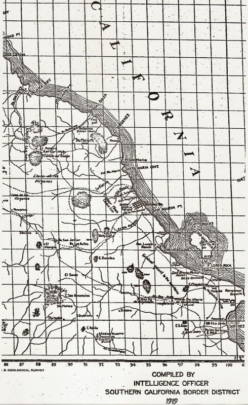
I have a set of maps, 5 sheets, of Lower California dated 1919 and 1920 compiled by the Intelligence Officer, Southern California Border District.
I have been told that there is a written report to accompany the maps.
Does anyone out there have a copy or can anyone confirm its existence ?
Direct email: normanc@olypen.com
|
|
|
rhintransit
Super Nomad
Posts: 1588
Registered: 9-4-2006
Location: Loreto
Member Is Offline
|
|
oh, the 'old' post was just a false start...will be interesting to see where that thread goes.
bump
reality\'s never been of much use out here...
|
|
|
Udo
Elite Nomad
Posts: 6364
Registered: 4-26-2008
Location: Black Hills, SD/Ensenada/San Felipe
Member Is Offline
Mood: TEQUILA!
|
|
I'll bet that DK knows!
Udo
Youth is wasted on the young!
|
|
|
Gaucho
Nomad
Posts: 405
Registered: 11-7-2008
Location: Laguna Beach/East Cape
Member Is Offline
Mood: Bohemia por favor...
|
|
DK...
|
|
|
David K
Honored Nomad
Posts: 65590
Registered: 8-30-2002
Location: San Diego County
Member Is Offline
Mood: Have Baja Fever
|
|

|
|
|
bajaguy
Elite Nomad
Posts: 9247
Registered: 9-16-2003
Location: Carson City, NV/Ensenada - Baja Country Club
Member Is Offline
Mood: must be 5 O'clock somewhere in Baja
|
|
More info, please
Who, or what agency......US Navy, US Army, US Customs, US Border Patrol?????
".....compiled by the Intelligence Officer, Southern California Border District......."
Does it list any names?????
|
|
|
bufeo
Senior Nomad
Posts: 793
Registered: 11-16-2003
Location: Santa Fe New Mexico
Member Is Offline
|
|
| Quote: | Originally posted by bajaguy
Who, or what agency......US Navy, US Army, US Customs, US Border Patrol?????
".....compiled by the Intelligence Officer, Southern California Border District......."
Does it list any names????? |
Since the Border Patrol wasn't officially established until 1924 these maps may...repeat, may...have been done by some IO in the U.S. Immigration
Service.
I have a copy ot "Mexico and Central Pilot", 1928 ed., and in it there's a hand-written note (in pencil) from the giver to the recipient of this book.
In the note, written in 1937, the writer makes a reference to an up-coming "aerial voyage" and later in the pilot adds this note (same handwriting,
also in pencil): "See the USIS notes and maps I sent you earlier."
I have no idea if this note is referring to the maps you have.
Allen R
|
|
|
David K
Honored Nomad
Posts: 65590
Registered: 8-30-2002
Location: San Diego County
Member Is Offline
Mood: Have Baja Fever
|
|
Also, a lot of stuff was going on during WWII. The U.S. was seriously thinking that the Japanese had or could have secret air bases in Baja California
to attack us from. That led to us putting up radar stations in Baja and building many of the airports that are still in use today (Ensenada, El
Rosario, Valle de Tridnidad, etc.). We also offered in 1941 to build a paved road down the peninsula, but were turned down on that one!
|
|
|
rockman
Junior Nomad
Posts: 98
Registered: 11-30-2003
Location: Port Hadlock, WA & Loreto BCS
Member Is Offline
|
|
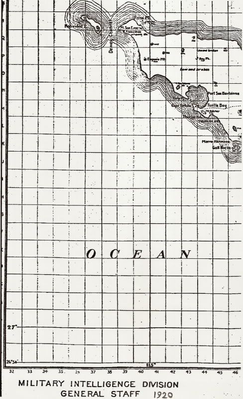
Each map sheet has 2 title blocks:
Lower right: "Compiled by Intelligence Officer Southern California border District 1919.
Lower Left: Military Intelligence Division General Staff 1920.
|
|
|
bajaguy
Elite Nomad
Posts: 9247
Registered: 9-16-2003
Location: Carson City, NV/Ensenada - Baja Country Club
Member Is Offline
Mood: must be 5 O'clock somewhere in Baja
|
|
Ahhhhhhhhhhhhh
My next move would be to do a FOIA (Freedom Of Information Act) request for the maps and reports in question, and any other data regarding the area in
that time frame.
Be specific in your request for data (maps, photographs, reports, notes)
I would send a request to:
US Army Corps of Engineers
Defense Mapping Agency
US Army Intelligence and Security Command
A Google search titled FOIA Request Address for each of the above agencies should result in mailing addresses.
Include all information on the subject you are requesting and possibly include a copy of the corner of the map with the information in your 10:26AM
post highlighted.
[Edited on 3-30-2012 by bajaguy]
|
|
|
bajaguy
Elite Nomad
Posts: 9247
Registered: 9-16-2003
Location: Carson City, NV/Ensenada - Baja Country Club
Member Is Offline
Mood: must be 5 O'clock somewhere in Baja
|
|
More info
http://www.archives.gov/research/guide-fed-records/groups/39...
http://www.archives.gov/research/guide-fed-records/groups/39...
|
|
|
David K
Honored Nomad
Posts: 65590
Registered: 8-30-2002
Location: San Diego County
Member Is Offline
Mood: Have Baja Fever
|
|
| Quote: | Originally posted by rockman
Each map sheet has 2 title blocks:
Lower right: "Compiled by Intelligence Officer Southern California border District 1919.
Lower Left: Military Intelligence Division General Staff 1920. |
Can you show them to us Norm? (SCAN, Upload to Photobucket at 800 pixels, post the IMG link here)
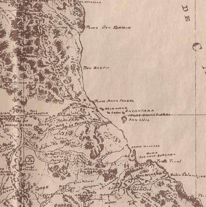
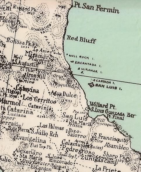
HERE is a 1919 map and a 1930 map of the area around Gonzaga Bay:
[Edited on 3-30-2012 by David K]
|
|
|
rockman
Junior Nomad
Posts: 98
Registered: 11-30-2003
Location: Port Hadlock, WA & Loreto BCS
Member Is Offline
|
|
Hi DK
Confirm your current email address and I will send a couple of map excerpts.
NKC
|
|
|
David K
Honored Nomad
Posts: 65590
Registered: 8-30-2002
Location: San Diego County
Member Is Offline
Mood: Have Baja Fever
|
|
| Quote: | Originally posted by rockman
Hi DK
Confirm your current email address and I will send a couple of map excerpts.
NKC |
You can use the one on my web site: info (at) vivabaja.com
change the (at) to @ 
Thank you...
|
|
|
David K
Honored Nomad
Posts: 65590
Registered: 8-30-2002
Location: San Diego County
Member Is Offline
Mood: Have Baja Fever
|
|
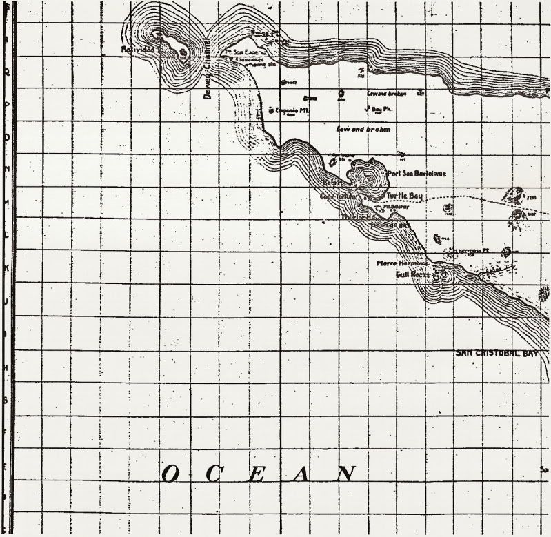
OK, here are the two maps Rockman sent to me...
| Quote: | Originally posted by rockman
Hi DK
Confirm your current email address and I will send a couple of map excerpts.
NKC |
To get all of the first one, I had to do two images:
The date was off the scan, so I copied it at the bottom... You recognize this as Bahia Tortugas region.
This is the Santa Rosalia region, and if you look closely, it has the Magdalena ruins shown as 'Mission Sta Maria de Magdalena', an error started by
Arthur North in his 1908 and 1910 Baja books.
Thank you Rockman! Send more if you can or want to!
|
|
|


