| Pages:
1
2 |
Bajaboy
Ultra Nomad

Posts: 4375
Registered: 10-9-2003
Location: Bahia Asuncion, BCS, Mexico
Member Is Offline
|
|
Hiking trails up to San Pedro Martir
After reading about Rancho Coyote, I got to thinking about trail running in the area. Does anyone know of any hiking trails up to San Pedro Martir?
I suppose we could run the roads but single track is my preference. My buddy and I contemplating a long trail run up that way....anything up to 40
miles would be considered.
Thanks in advance for any information. We're also going to email the ranch but figured Astrobaja or someone else might have info.
Thanks
Zac
|
|
|
Barry A.
Select Nomad
Posts: 10007
Registered: 11-30-2003
Location: Redding, Northern CA
Member Is Offline
Mood: optimistic
|
|
There are several non-vehicular "trails" from near Socorro (up the road from the Meling Ranch) up into the Sierra San Pedro Martir. Nomad Vince and I
have both riden (horse) and hiked them back in the early '50's. Not sure of their condition today, tho.
Barry
|
|
|
David K
Honored Nomad
Posts: 65590
Registered: 8-30-2002
Location: San Diego County
Member Is Offline
Mood: Have Baja Fever
|
|
Read Graham's 'Nearer My Dog to Thee' and also get John Robinson's 'Camping and Climbing in Baja', old but valuable logs of the San Pedro Martir
trails.
|
|
|
DavidE
Ultra Nomad
Posts: 3814
Registered: 12-1-2003
Location: Baja California México
Member Is Offline
Mood: 'At home we demand facts and get them. In Mexico one subsists on rumor and never demands anything.' Charles Flandrau,
|
|
My dos centavos would be to get a G.P.S. and make way-points from start to finish. I could not believe how similar that country looks: Rolling ridge
after rolling ridge. If we didn't have an arriero along my bones would have been bleaching somewhere up there long ago..
A Lot To See And A Lot To Do
|
|
|
mtgoat666
Platinum Nomad
Posts: 21162
Registered: 9-16-2006
Location: San Diego
Member Is Offline
Mood: Hot n spicy
|
|
| Quote: | Originally posted by Bajaboy
After reading about Rancho Coyote, I got to thinking about trail running in the area. Does anyone know of any hiking trails up to San Pedro Martir?
I suppose we could run the roads but single track is my preference. My buddy and I contemplating a long trail run up that way....anything up to 40
miles would be considered.
Thanks in advance for any information. We're also going to email the ranch but figured Astrobaja or someone else might have info.
Thanks
Zac |
the edges of plateau are very steep, not many good trails. probably a lot of stock trails, but those are not mapped, just ranchers know their routes.
jerry schaad's map of plateau is still best map, shows most trails and roads, and best published map available to buy.
you could have lots of fun running up there on plateau, as understory is clear, but the run on/of the plateau is a lot of bushwhacking in scrub
vegetation.
not sure you will find good info before you leave for SPM. suggest you buy schaad's map, then go explore and look for routes using car or mt bike to
get around. then come back later for a longer run. on the plateau, the old roads are some great mt biking, nice grussy ground.
|
|
|
Bajaboy
Ultra Nomad
Posts: 4375
Registered: 10-9-2003
Location: Bahia Asuncion, BCS, Mexico
Member Is Offline
|
|
All great ideas. One thought might be to stay at Mike's place and then explore a bit with some day hikes/runs. Mainly looking for a new adventure
and an excuse to explore the area a bit more. I've got a few other Baja runs on my bucket list but I'd like to knock this one out this year.
|
|
|
wilderone
Ultra Nomad
Posts: 3915
Registered: 2-9-2004
Member Is Offline
|
|
There is a short book called Camping and Climbing in Baja by John
Robinson. There are a cople maps; the routes are explained. Says there are Indian trails, cattleman trails and that there is no reason to make
recreational trails. Best is to be guided by the info you have, and know how to use map and compass and try to get a decent topo. I made a pdf of
one of the maps that shows the trails, but I can't figure out how to post it here. It's an older publication, but probably the area hasn't changed
much except for the main road. I'll make copies of the pertinent pages and mail them to you if you'd like.
|
|
|
Baja Bucko
Nomad
Posts: 288
Registered: 9-23-2003
Member Is Offline
|
|
Yes, Robinson's book is a classic...traveling w speed on foot-keep your eyes open for rattlesnakes-they are BAD.......you do not want to end up like
the guy several years ago who liked to travel fast and light-and died up there waiting for a navy helicopter to rescue him. Nailed by a
rattlesnake....
30 years ago when I was on my 3rd trip to the mission site via La Grulla-we saw plenty of the buggers. Not someplace you want to get bitten as rescue
takes awhile.
My other 4WD is a Baja Mule!
La Mula Mil Survivor 2013-2014!
1000 miles by mule from the tip to Tecate!
|
|
|
mtgoat666
Platinum Nomad
Posts: 21162
Registered: 9-16-2006
Location: San Diego
Member Is Offline
Mood: Hot n spicy
|
|
| Quote: | Originally posted by wilderone
There is a short book called Camping and Climbing in Baja by John
Robinson. There are a cople maps; the routes are explained. Says there are Indian trails, cattleman trails and that there is no reason to make
recreational trails. Best is to be guided by the info you have, and know how to use map and compass and try to get a decent topo. I made a pdf of
one of the maps that shows the trails, but I can't figure out how to post it here. It's an older publication, but probably the area hasn't changed
much except for the main road. I'll make copies of the pertinent pages and mail them to you if you'd like. |
robinson's book is good. schaad's map is better and more useful for navigating. get 'em both.
yes, watch for snakes, but that's same as anywhere in mtns of alta or baja
|
|
|
Bajaboy
Ultra Nomad
Posts: 4375
Registered: 10-9-2003
Location: Bahia Asuncion, BCS, Mexico
Member Is Offline
|
|
See rattlers all the time in San Diego...but in the remote wilderness could be a big problem. I'll be traveling with a gps and my spot....just in
case. Thanks again for all the good advice.
|
|
|
David K
Honored Nomad
Posts: 65590
Registered: 8-30-2002
Location: San Diego County
Member Is Offline
Mood: Have Baja Fever
|
|
I have posted maps from both Robinson and Schaad here on Nomad... and Zac, you can come over and see the map and book, and I will loan them to you to
study and use...
Robinson's:
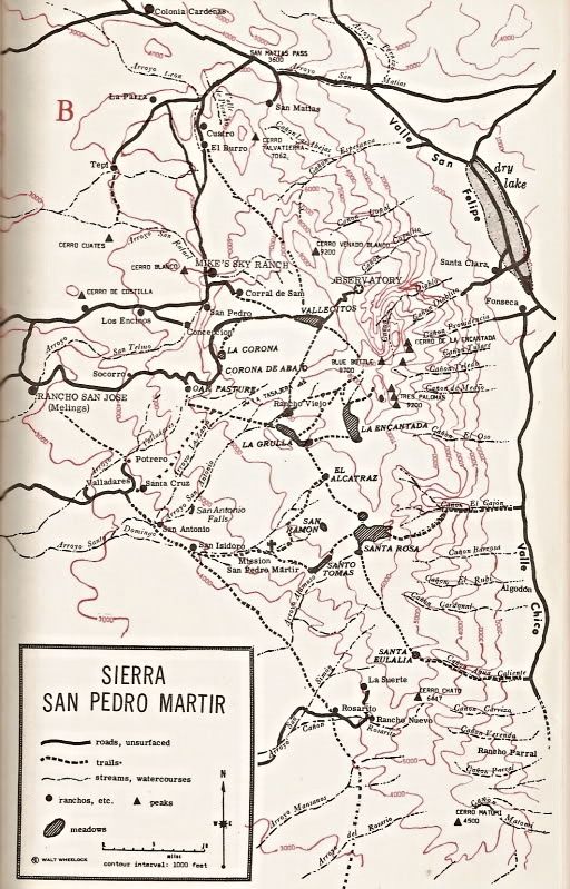
Close up:
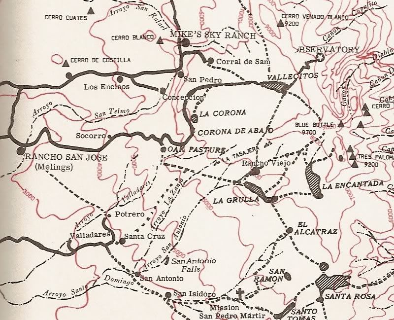
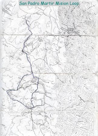
Here is Bicycle/ Baja Bob's map from their hike to the mission:
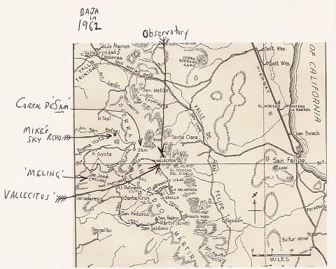
Howard Gulick's (with some notes I added):
|
|
|
wilderone
Ultra Nomad
Posts: 3915
Registered: 2-9-2004
Member Is Offline
|
|
Yes, I've heard about the rattlers around there. Be sure to wear some good gaitors.
|
|
|
Mexitron
Ultra Nomad
Posts: 3397
Registered: 9-21-2003
Location: Fort Worth, Texas
Member Is Offline
Mood: Happy!
|
|
David---On the first map is a place called Santa Eulalia ( on the trail from Agua Caliente to Santa Rosa)---don't recall seeing that name before---is
that a rancho or a visita?
|
|
|
David K
Honored Nomad
Posts: 65590
Registered: 8-30-2002
Location: San Diego County
Member Is Offline
Mood: Have Baja Fever
|
|
| Quote: | Originally posted by Mexitron
David---On the first map is a place called Santa Eulalia ( on the trail from Agua Caliente to Santa Rosa)---don't recall seeing that name before---is
that a rancho or a visita? |
John Robinson (Camping and Climbing in Baja) describes it as a region using the term 'Santa Eulalia country' as well as 'rolling plateau country',
between Santa Rosa meadow and the top of Agua Caliente Canyon... He says vaqueros drive their cattle to feed during summer months there. In the note
on Agua Caliente Canyon, Robinson mentions the Indian trail ascends the canyon to Santa Eulalia.
Very little is available on Mision San Pedro Martir history... even the first site of the mission (in La Grulla meadow) was a mystery until just a few
years ago. San Isidoro was a visita or way station for San Pedro Martir, but no historic record of any place called Santa Eulalia appears in my
collection of books.
|
|
|
David K
Honored Nomad
Posts: 65590
Registered: 8-30-2002
Location: San Diego County
Member Is Offline
Mood: Have Baja Fever
|
|
| Quote: | Originally posted by mtgoat666
| Quote: | Originally posted by wilderone
There is a short book called Camping and Climbing in Baja by John
Robinson. There are a cople maps; the routes are explained. Says there are Indian trails, cattleman trails and that there is no reason to make
recreational trails. Best is to be guided by the info you have, and know how to use map and compass and try to get a decent topo. I made a pdf of
one of the maps that shows the trails, but I can't figure out how to post it here. It's an older publication, but probably the area hasn't changed
much except for the main road. I'll make copies of the pertinent pages and mail them to you if you'd like. |
robinson's book is good. schaad's map is better and more useful for navigating. get 'em both.
yes, watch for snakes, but that's same as anywhere in mtns of alta or baja |
Jerry Schad's is a great map, but only shows the north half of the SPM Park, and a close up of Diablo Mountain climbing routes, on the other side.
However, for Zac, it probably covers any area he would be hiking in... closer to the observatory road.
It was published in 1988 by Centra Publications, 4705 Laurel St. San Diego 92105. ISBN 0-9617288-2-5
|
|
|
Bajaboy
Ultra Nomad
Posts: 4375
Registered: 10-9-2003
Location: Bahia Asuncion, BCS, Mexico
Member Is Offline
|
|
DK, thanks for the maps....getting some good ideas. Ideally, we might stay a few days at Mike's and check out that area and maybe scout a route up
the mountain. I'm open to running the dirt roads but would be interested in single track. I think we'll find out more info from the ranchers.
Thanks for all the input so far. We're tentatively shooting for mid to late fall.
|
|
|
Bajaboy
Ultra Nomad
Posts: 4375
Registered: 10-9-2003
Location: Bahia Asuncion, BCS, Mexico
Member Is Offline
|
|
Hey DK, where on the maps is Mike's place? I have an idea but not sure exactly.
|
|
|
David K
Honored Nomad
Posts: 65590
Registered: 8-30-2002
Location: San Diego County
Member Is Offline
Mood: Have Baja Fever
|
|
| Quote: | Originally posted by Bajaboy
Hey DK, where on the maps is Mike's place? I have an idea but not sure exactly. |
Concepcion... the road to it, from the observatory road is near Socorro, on the Robinson map.
|
|
|
mtgoat666
Platinum Nomad
Posts: 21162
Registered: 9-16-2006
Location: San Diego
Member Is Offline
Mood: Hot n spicy
|
|
| Quote: | Originally posted by David K
| Quote: | Originally posted by Mexitron
David---On the first map is a place called Santa Eulalia ( on the trail from Agua Caliente to Santa Rosa)---don't recall seeing that name before---is
that a rancho or a visita? |
John Robinson (Camping and Climbing in Baja) describes it as a region using the term 'Santa Eulalia country' as well as 'rolling plateau country',
between Santa Rosa meadow and the top of Agua Caliente Canyon... He says vaqueros drive their cattle to feed during summer months there. In the note
on Agua Caliente Canyon, Robinson mentions the Indian trail ascends the canyon to Santa Eulalia.
Very little is available on Mision San Pedro Martir history... even the first site of the mission (in La Grulla meadow) was a mystery until just a few
years ago. San Isidoro was a visita or way station for San Pedro Martir, but no historic record of any place called Santa Eulalia appears in my
collection of books. |
when was last time you were on the plateau, dk?
|
|
|
latina
Nomad
Posts: 210
Registered: 3-19-2011
Location: La Paz
Member Is Offline
|
|
You can also see the trails on Google Earth. Fly to Sierra San Pedro Martir and you will be able to see the terrain and compare the maps to the Spot
and Google images.
|
|
|
| Pages:
1
2 |


