MexicoTed
Senior Nomad

Posts: 708
Registered: 8-2-2004
Member Is Offline
|
|
Advice: La Paz to San Juan de la Costa & beyond?
Any Nomads out there driven from La Paz to San Juan de la Costa and beyond recently? What is the farther north I can go staying somewhat near the
coastline? My map says San Evaristo? Where do I need to head back to Hwy 1 to head north?
Taking a Baja adventure on roads less traveled this June and any advice or ideas will be greatly appreciated.
Thanks,
Ted
|
|
|
LaPazGringo
Nomad
Posts: 237
Registered: 2-28-2012
Location: La Paz
Member Is Offline
|
|
Ted, there's some talk here you'll be interested in:
http://forums.bajanomad.com/viewthread.php?tid=59908
I'm very interested in the same route and can't wait to add Mission San Luis Gonzaga to my list of visited missions.
|
|
|
David K
Honored Nomad
Posts: 65590
Registered: 8-30-2002
Location: San Diego County
Member Is Offline
Mood: Have Baja Fever
|
|
San Evaristo to Mision San Luis Gonzaga... if you don't see the connecting roads, you don't have the right map!
Look at the AAA map:
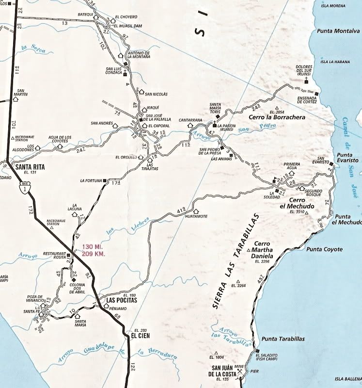
Further out...
Oh, and Ted... that route is (was) the NORRA race course southbound, just a week ago!
[Edited on 5-9-2012 by David K]
|
|
|
Jack Swords
Super Nomad
Posts: 1097
Registered: 8-30-2002
Location: Nipomo, CA/La Paz, BCS
Member Is Offline
|
|
Did it twice earlier this year (Highway 1 to Gonzaga to Evaristo to La Paz) 2010 4Runner, never switched into 4WD, less than a full tank used. Many
intersecting roads, most not on maps. Stopped at ranchos and visited and got good information. Generally head east. Did it in 2 days, one night
camped out. Mechudo part of road twisty, but previous bad spots from 2WD digging out going uphill have all been concreted and are quite good. Much
improved over previous years I have traveled it. The permanentes "washboard" between San Juan de la Costa and Evaristo are maddening, always have
been. Saw NO vehicles traveling the roads in two days. We travel with compressor, ham radio and handheld GPS and TOPO topographical map of Baja and
the Almanac. Still, GPS and maps didn't have roads we were on. Have now netbook computer and USB GPS unit that attaches to roof or dash. Able to
use Google Earth (cached) and see where we are AND see the road we are on (dirt roads are very visible in GE). Unit records tracks so you can go back
from where you started. Already used in Mojave it will be the thing to wander around that area between SOC, Constitucion, La Paz. Next fall we'll be
back out there.
|
|
|
Martyman
Super Nomad
Posts: 1904
Registered: 9-10-2004
Member Is Offline
|
|
I hooked a dorado from shore at Punta Mechudo.
|
|
|
KurtG
Super Nomad
Posts: 1211
Registered: 1-27-2004
Location: California Central Coast
Member Is Offline
Mood: Press On Regardless!!
|
|
Jack,
What is the brand and cost of the USB GPS you are using. Sounds like a great sytem.
|
|
|
Jack Swords
Super Nomad
Posts: 1097
Registered: 8-30-2002
Location: Nipomo, CA/La Paz, BCS
Member Is Offline
|
|
http://www.amazon.com/GlobalSat-BU-353-Waterproof-USB-Receiv...
the xgps 150 is wireless (Bluetooth) and requires no USB cable, Amazon carries it too.
Using Google Earth (cached before) allows full use of GE features away from Internet connection. Typical steep learning curve...lots of free
software out there to help.
|
|
|
Fernweh
Nomad
Posts: 444
Registered: 2-24-2011
Location: Centenario, BCS
Member Is Offline
|
|
| Quote: | Originally posted by Jack Swords
http://www.amazon.com/GlobalSat-BU-353-Waterproof-USB-Receiv...
the xgps 150 is wireless (Bluetooth) and requires no USB cable, Amazon carries it too.
Using Google Earth (cached before) allows full use of GE features away from Internet connection. Typical steep learning curve...lots of free
software out there to help. |
I did use a similar set up, blueooth GPS receiver and a special cache saving program to use the GE features on our recent adventure from Aqua Verde to
Timbabichi. Very easy to use, but it is not a free program.
|
|
|
Jack Swords
Super Nomad
Posts: 1097
Registered: 8-30-2002
Location: Nipomo, CA/La Paz, BCS
Member Is Offline
|
|
Earthbridge is free as is GooPs. Both enhance the GPS use with GE. GE will, in itself, work with the USB GPS, but the tracking leaves something to be
desired. I am using Earthbridge with its tracking path and it works fine. On our boat, there is software for this application, but it is not free.
Lots of additional programs on the Internet from map servers etc. that can be used with the computer. The TOPO products (not free) will work with the
GPS, but lack all the little roads. At least GE shows roads, different elevations, etc. Great trip by-the-way, I'm jealous!
|
|
|
Fernweh
Nomad
Posts: 444
Registered: 2-24-2011
Location: Centenario, BCS
Member Is Offline
|
|
| Quote: | Originally posted by Jack Swords
Earthbridge is free as is GooPs. Both enhance the GPS use with GE. GE will, in itself, work with the USB GPS, but the tracking leaves something to be
desired. I am using Earthbridge with its tracking path and it works fine. On our boat, there is software for this application, but it is not free.
Lots of additional programs on the Internet from map servers etc. that can be used with the computer. The TOPO products (not free) will work with the
GPS, but lack all the little roads. At least GE shows roads, different elevations, etc. Great trip by-the-way, I'm jealous! |
Yeah, it was a nice trip, made lots of new friends, but long driving hrs.
The cache software I'm using is called GPS for Google Earth. It allows you to create multiple 2g max cache file, and save them to your harddrive.
Free evaluation at http://www.coipos.com/en/order.php
|
|
|
David K
Honored Nomad
Posts: 65590
Registered: 8-30-2002
Location: San Diego County
Member Is Offline
Mood: Have Baja Fever
|
|
Ted??? You get lost already??? Oh Ted...
|
|
|
MexicoTed
Senior Nomad
Posts: 708
Registered: 8-2-2004
Member Is Offline
|
|
Hey all, I'm here just away on business trip. Thanks for all the answers. A couple follow up questions.
Is it worth it to drive out to the ruins of Dolores del Sur?
If we head north from Mission San Luis Gonzaga, where to we turn east to reach Timbabichi? I know there was just a trip there, but coming from Agua
Verde to the north.
Thanks,
Ted
|
|
|
David K
Honored Nomad
Posts: 65590
Registered: 8-30-2002
Location: San Diego County
Member Is Offline
Mood: Have Baja Fever
|
|
Dolores Apate has no road access. Dolores Chilla, La Pasion is on a road. Jack Swords reported a pig ranch was on the site.
|
|
|
David K
Honored Nomad
Posts: 65590
Registered: 8-30-2002
Location: San Diego County
Member Is Offline
Mood: Have Baja Fever
|
|
Los Dolores Apate is the site near the coast, by Rancho Los Dolores. You can walk to it down the Camino Real a few miles from the auto road to
Ensenada de Cortez (Los Burros) or have a panga drop you off on the beach and walk about 3 miles to the site in the canyon. Lot's to see there per Ed
Vernon's book, 'Las Misiones Antiguas' (I have not been to either of the Dolores ruins).
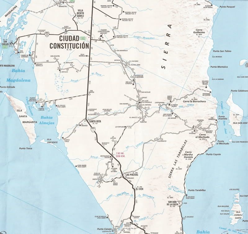
Los Dolores Chilla (at La Pasion) is along the same road to Ensenada de Cortez, but much closer to San Luis Gonzaga mission. See the AAA map I posted
above as it is very close to being accurate showing the two sites with ruins, but calling the final site by its more common name, La Pasion. The Baja
Almanac is incorrect at pointing out the La Pasion site... the true site is called La Capilla on the Almanac, just east of La Presa. Also, the Almanac
shows a road to Los Dolores, and it is a foot or mule trail.
GPS and satellite views of all missions are found in my Baja Missions page at http://vivabaja.com/bajamissions in the Part 4 section.
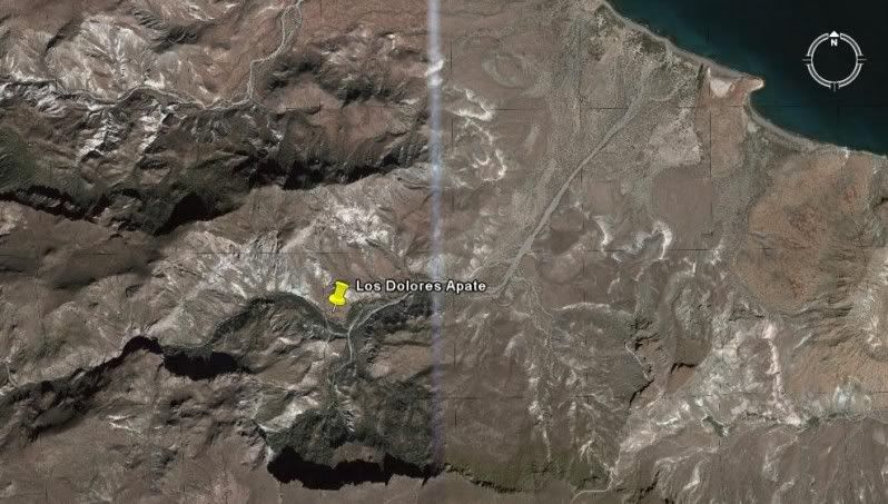
LOS DOLORES APATE 25°03'19.04" 110°53'03.33" Access by foot/ mule trail off road to Los Burros
about 15 miles norteast of La Presa and Los Dolores Chilla (La Pasion).
------------------------------------------------------------------------------------
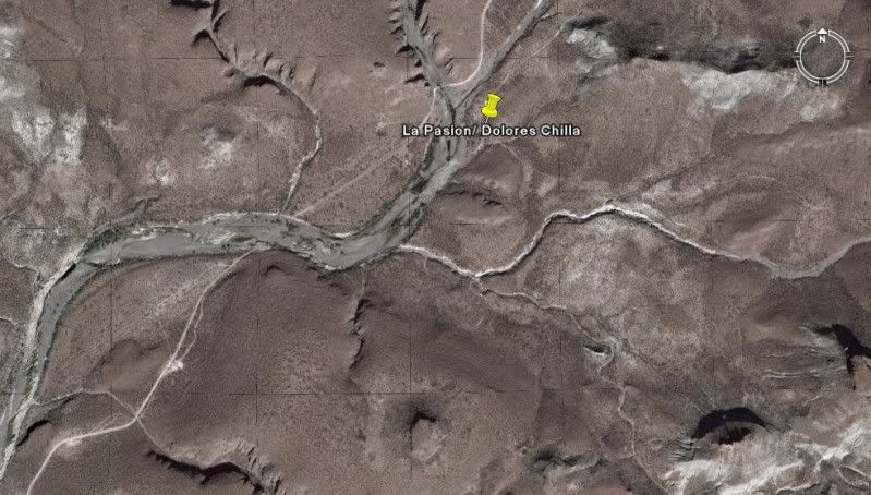
LOS DOLORES CHILLA (La Pasion) 24°53'14.4" 111°01'49.81" Just east of Rancho La Presa at Rancho
La Capilla off the road to San Pedro de la Presa.
[Edited on 5-23-2012 by David K]
|
|
|
Jack Swords
Super Nomad
Posts: 1097
Registered: 8-30-2002
Location: Nipomo, CA/La Paz, BCS
Member Is Offline
|
|
There is a trail down the cliff to mission Dolores, but difficult to find and I can't find my GPS coordinates for it. The road down to Los Burros is
doable, but quite steep. As to La Pasion mission site, it was rubble 10 years ago (David's Mission site might have a photo) and not remarkable.
Earlier this year we went back to La Pasion and it was covered by a goat ranch. Many more casitas in the area and "ranching" compared to 10 years ago.
The ranch at Dolores and the mission are interesting. You can get a panga at Evaristo, but the anchorage off the ranch is open roadstead and any
other boat would be at risk anchored there, if unattended. Not a panga, of course. I believe the AAA map shows a road to Dolores, but there is none.
However, the ranch has a couple of pickups driving around. Rancho La Presa and the surrounding area are closed and a "resort" of some type. New
consruction etc. Nobody there though. No access to ranch, de la Toba's graves. Lots of water in the rio earlier this year, Bosques one and two were
green and lush. Report back what you find.
|
|
|
David K
Honored Nomad
Posts: 65590
Registered: 8-30-2002
Location: San Diego County
Member Is Offline
Mood: Have Baja Fever
|
|
The latest AAA map (see above) corrected the road to Los Dolores error and now shows the mission north of the road to Los Burros (Ensenada de Cortez).
Here is Jack's photo of the final Dolores site (La Pasion) about 10 years ago, followed by one taken in 1950:


GPS: 24°53'14.4" 111°01'49.8"
|
|
|
MexicoTed
Senior Nomad
Posts: 708
Registered: 8-2-2004
Member Is Offline
|
|
Thanks DK and Jack. Any info helps immensely. I will certainly do a trip report with lot's of photos when I return. We also plan to be in Comondu,
Bahia Magdalena, etc.
Ted
|
|
|


