| Pages:
1
2 |
mcfez
Elite Nomad

Posts: 8678
Registered: 12-2-2009
Location: aka BN yankeeirishman
Member Is Offline
|
|
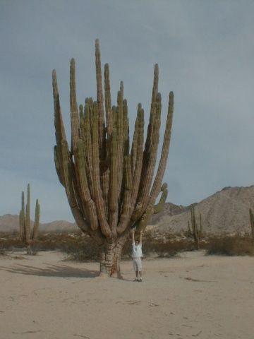
Just south of the town of San Felipe is a cactus "forest" of the worlds largest cactus in the Valley of the Giants natural preserve. A two-wheeled
drive car can get you to the first rest stop where you can get out and walk around but you won't be able to see all the "named cactus" without the all
terrain vehicle. About 5 bucks to get in.
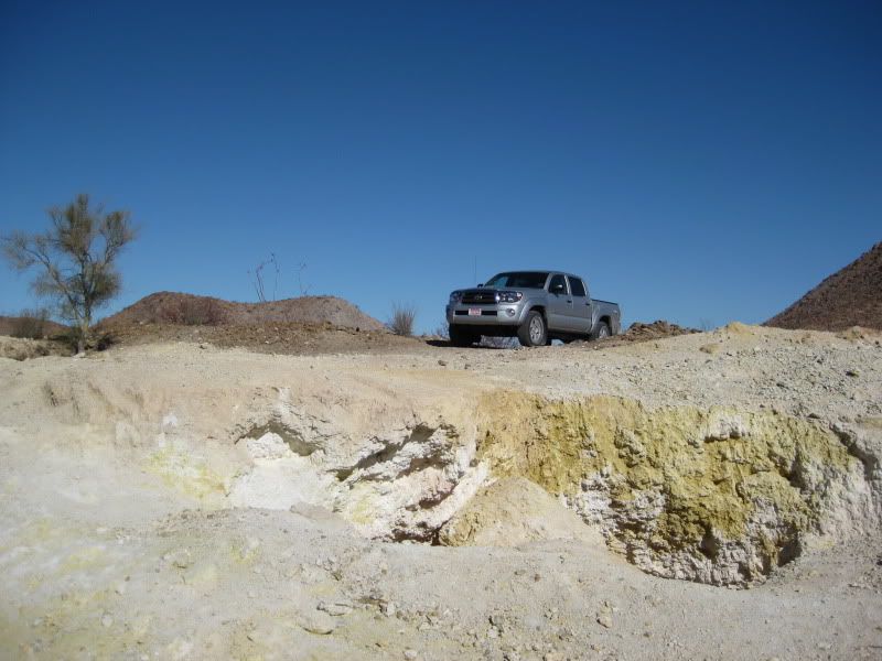
Sulfur mines K45'ish
Very cool place to pick up a yellow rock and light it on fire :-) Old mining area. Few structures left.
DK's site has good info
http://vivabaja.com/204/page11.html
Puertecitos hot mineral baths is a great spot to soak your bones. The hot springs are located a short drive from the Campo Puertecitos entrance on a
medium-quality dirt road. Go past the camping area to its left, toward the residential area, and once in the residential area, generally stay to the
right at just about every fork in the dirt road except when you see the marked entrance to the springs on the left. About ten bucks to use. Worth it
because they installed concrete ramps to the hot springs.
The pier there is GREAT for fishing (for the kids). Cast out to your right from the end of the pier...you'll catch every time. The camp itself is not
upgraded. Gas is avail...if the station is not open, go around to the rear. Attendant will be there......or go to the camp and ask for gas (station is
owned by the camp).

Black Mountain 8 miles or so pass Puertecitos ......north side of it has piles and piles of sea shells, great spot for whale watching (in season) and
surf fishing that will keep the reel busy.
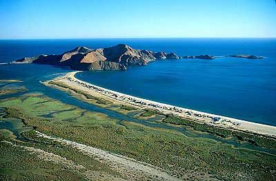
Gonzaga Bay....Alfonsina's Motel / restaurant is the best game in town and the scenery at your doorstep there is amazing. Rates are about 60 a nite
and you get no key to the room. No locks :-) Fantastic swimming, hiking, shore exploring. Great fishing. gas and full market (has a phone in there
for the public) There are several campsites within a few miles of Alfonsina's......
When leaving town after your turn at the South end of the Airport runway you'll be heading West and be looking toward the mountains and the Pemex gas
station. look for a large white rocky area at the base of the mountains. This an area that has an intermittent geyser. The whole canyon there is full
of onyx, which is banded and very colorful.. You'll have to find your way into that area, and it requires a short hike to get to it, but it's worth it
Punta Final south of Gonzaga Bay .......excellent area for snorkeling and fishing. Once arrive at the little township...look at your right for a dirt
road that goes over a hill. Good spot there to camp and to set off for snorkeling.
From there the drive up the high country to Highway 1 is awesome. Make sure to stop by Coco's corner and buy a few colas. I strongly suggest you go to
Bay of Los Angeles,
A few hours away.......
Daggett's Beach CampingDaggett's Beach Camping
Right on the Sea of Cortez on a Beautiful Beach
Bahia De Los Angeles, Baja California
Phone/Fax message: (011-52-) 615-650-3206
E-mail: rubendaggett@hotmail.com
Kayaking to clamming to swimming......a full town a few miles away. We love this place. Make sure to go to the most southern part of the bay....just
fantastic exploring.
Old people are like the old cars, made of some tough stuff. May show a little rust, but good as gold on the inside.
|
|
|
David K
Honored Nomad
Posts: 65590
Registered: 8-30-2002
Location: San Diego County
Member Is Offline
Mood: Have Baja Fever
|
|
| Quote: | Originally posted by Sweetwater
| Quote: | Originally posted by Hook
Personally, I have not seen a "Not to be missed thing to do" in San Felipe.
The only thing that might come close is experiencing the great tidal change. It's pretty incredible seeing the tide go out a quarter mile in a couple
hours and then walking out on all that sand. That doesnt happen in many parts of the world. I think San Felipe's tides are in the top ten greatest
tidal changes in the world. |
This is a way cool tip....where do I track these tidal changes?
and thanks for those exemplary photos. |
Tide Calendar is posted on the San Felipe web site, this page: http://sanfelipe.com.mx/weather/tide-calendars/
|
|
|
David K
Honored Nomad
Posts: 65590
Registered: 8-30-2002
Location: San Diego County
Member Is Offline
Mood: Have Baja Fever
|
|
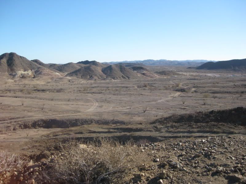
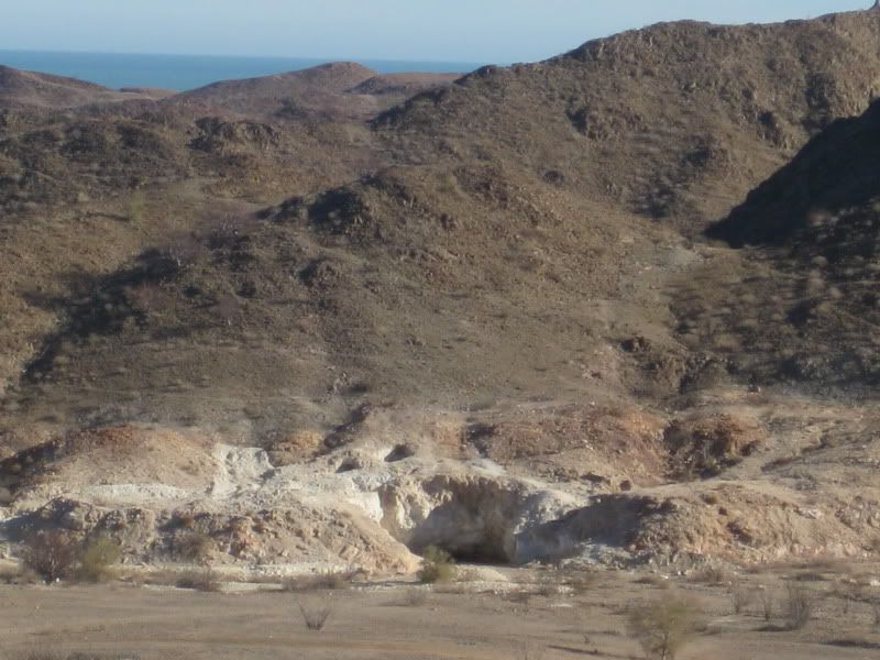
Sulfur Mine & Gonzaga's Onyx/Soda Springs
McFez made an excellent tour page and mentioned both the Sulfur Mine (23 miles south of San Felipe) and the white slope onyx or soda spring
over-looking Gonzaga Bay.
In addition to the the link he gave for the sulfur mine, here is a couple newer photos: http://vivabaja.com/106/page2.html and the first President's Day Group trip there, in 2001: http://www.vivabaja.com/shell/
The last time I was at the Sulfur Mine was New Years 2010, here are those photos:
Later Baja Angel and I drove west to the sulfur mine along the old Puertecitos road and exlored around there. I found a really steep hill to climb and
made great photo location.
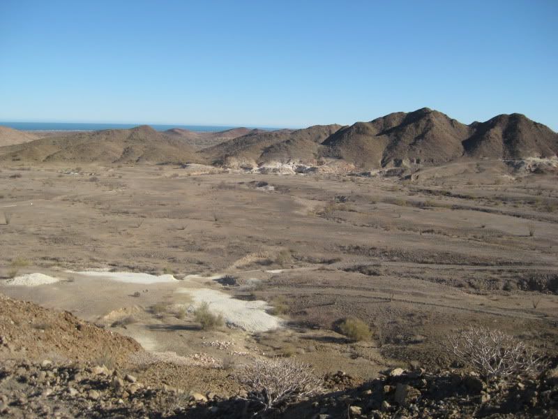
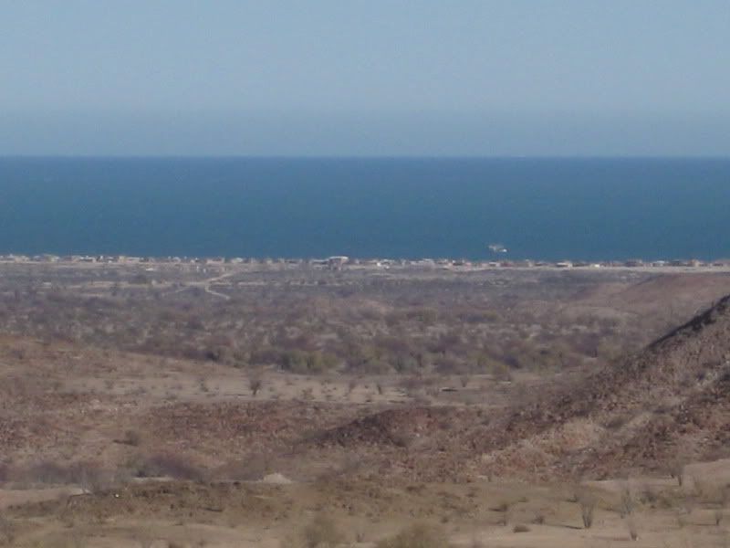
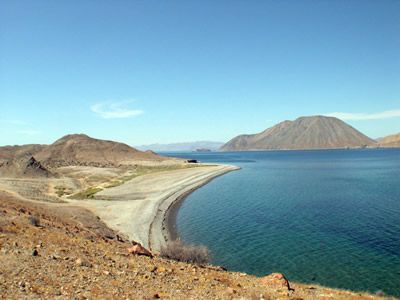
(above: Bahia Santa Maria from the Sulfur Mine hilltop)
The above is from my trip report, that includes pics at Bahia Santa Maria and BajaRob's home: http://forums.bajanomad.com/viewthread.php?tid=43469
The Onyx Spring is reached from a road that goes west from Rancho Grande... and you can see it from the beach near the east end of the Rancho Grande
runway... looks like a glacier.
Here are my photos from 2002: http://www.vivabaja.com/1102/page5.html
|
|
|
Phil S
Super Nomad
Posts: 1205
Registered: 10-28-2003
Member Is Offline
Mood: After 34 years. Still in love w/ my wife
|
|
Wendy & I made it through in our Sienna van November of last year. No problems, except for the vada's before you get to San Felipe?????
Yikes!!!!!!!!! Drive slow, otherwise you'll leave the ground (after bottoming out) I think David K has these described by km markers. I had
forgotten about the no locks on the doors. But wasn't a problem for us, because we travel with a little device that anchors in the latch hole, and has
a swivel plate so when you close the door on it, it swings & clicks, and short of "kicking in the door", you are secure. We've used this many
times in our travels in Europe & Mexico/Baja. Not sure if it would pass airport security these days. It's not a weapon by any means. But good
night sleeps when it's installed. Good to read about the hot springs. Sure missed knowing
about the hot springs. That is one we'll take in next trip down, which should be late October 2013. (that is if we all make it passed Dec 21st, at
11:12 whatever.)
[Edited on 12-4-2012 by Phil S]
|
|
|
mcfez
Elite Nomad
Posts: 8678
Registered: 12-2-2009
Location: aka BN yankeeirishman
Member Is Offline
|
|
Time is important for the springs. Check the tide for low point. Arrive just as that's to happen. Easy access ...even for the elder
| Quote: | Originally posted by Phil S
Wendy & I made it through in our Sienna van November of last year. No problems, except for the vada's before you get to San Felipe?????
Yikes!!!!!!!!! Drive slow, otherwise you'll leave the ground (after bottoming out) I think David K has these described by km markers. I had
forgotten about the no locks on the doors. But wasn't a problem for us, because we travel with a little device that anchors in the latch hole, and has
a swivel plate so when you close the door on it, it swings & clicks, and short of "kicking in the door", you are secure. We've used this many
times in our travels in Europe & Mexico/Baja. Not sure if it would pass airport security these days. It's not a weapon by any means. But good
night sleeps when it's installed. Good to read about the hot springs. Sure missed knowing
about the hot springs. That is one we'll take in next trip down, which should be late October 2013. (that is if we all make it passed Dec 21st, at
11:12 whatever.)
[Edited on 12-4-2012 by Phil S] |
Old people are like the old cars, made of some tough stuff. May show a little rust, but good as gold on the inside.
|
|
|
bajafam
Senior Nomad
Posts: 654
Registered: 9-6-2009
Location: Northeast AZ, Bahia Asuncion, BCS :)
Member Is Offline
Mood: DLTBGYD
|
|
Thanks guys!! Love it!! So excited to check out some of your suggestions!!
|
|
|
David K
Honored Nomad
Posts: 65590
Registered: 8-30-2002
Location: San Diego County
Member Is Offline
Mood: Have Baja Fever
|
|
There are too many poorly engineered dips between San Felipe and Puertecitos to try and document... just don't exceed 50 mph (the speed limit that
actually fits here) so you can either slow enough at a vado (dip) or if you don't slow, you won't get too far airborne... South of Puertecitos is a
totally different, high speed highway for 34 miles or where ever the pavement ends.
Before they finish paving to Hwy. 1, they need to replace the road north of Puertecitos to make it work for trucks and RVs, etc. The dips as they are
now will cause a lot of accidents and damaged vehicles.
|
|
|
David K
Honored Nomad
Posts: 65590
Registered: 8-30-2002
Location: San Diego County
Member Is Offline
Mood: Have Baja Fever
|
|
Baja Fam... here is my original 2002 Gonzaga side trips report, from which came the Onyx springs discovery, and other area sites, a couple are 2WD
friendly even!
Another 'old' Nomad Trip Report from 2002: Gonzaga Bay Sidetrips
Gonzaga Bay Side Trips Thanksgiving 2002
My Thanksgiving week vacation with my 13 year old son Chris began Tuesday afternoon. Daughter Sarah was spending the holiday with her mom.
We crossed the border about 5:00pm and were in Ensenada in no time at all. Lobster dinner at Las Cazuelas (expensive and not that good), but it was
good father and son time! We were off to San Quintin where it started to rain, and got to Gypsy's indoor camping building at 10 o'clock.
It rained all night, but we stayed dry. Laura's awesome breakfast burrito and hot coffee for a good start, Chris wasn't hungry. The rain stayed with
us until San Agustin. We saw a semi wreck in the boojum hills... those truckers just can't slow down enough.
Past Cataviña, we pulled over as Chris was finally hungry for a bowl of Captain Crunch... I hiked a bit among the boojum trees.
FYI: no more military stop at El Rosario Mesa or past Santa Ynez's driveway (Cataviña).
The day remained cloudy, but dry after San Agustin. We left the pavement at Laguna Chapala and headed for Coco's Corner. The graded dirt road started
excellent and 55 mph was easy. As we neared Coco's Corner, the conditions required slowing to 40 something.
Coco was in Ensenada, but an amigo was minding the store in his absence. I signed the guest book and saw Coco's sketch from my last visit on Jan. 2,
2002.
Here we took Chris's dirt bike (Kawasaki 110) off my truck so he could start to ride... he was so anxious for this part! We both zipped along about 40
mph to our first side trip: The Green Pools!
Located in La Turquesa Canyon, 2.7 miles west from the main road, I last visited them in 1975. A turquoise mine is located a mile further up the
canyon. This is also the bottom of Kacey Smith's XR Motorcycle GPS ride up to Highway One... also called 'Coco's Shortcut'!
The pools were photographed by Wayno recently ( http://vivabaja.com/wayno ).
The turnoff to La Turquesa Canyon is 2.4 miles north of the abandoned ranch at Las Arrastras, north of Coco's, at N29º34.347' W114º21.943' (NAD27).
The end of the road at the pools is at N29º33.716' W114º23.890'.
--------------------------------------------------------------------
We returned to the main road and headed to Alfonsina's, on Gonzaga Bay.
On the road to Gonzaga, both Chris on his motorcycle and me in my truck got flats! Like father, like son?
Rancho Grande has an impressive tire repair facility and patched me up for only $5. Pedro was the man in charge and 'Cecil' made the repair. While
there, I noticed the white hillside to the west, that might be the onyx springs I read about in an old Desert Magazine article? First however, I
wanted to find Molino de Lacy, to the south, near Punta Final.
Timothy Walker has several great photos on his web site of Molino de Lacy under 'Mystery Solved' ( http://timsbaja.com ). Molino means mill and William Lacy was the man who operated it in the late 1800's. His well preserved grave is on one side
of the hill, and the mill was on the other. One of my irrigation customers is his great grand daughter. When she knew of my Baja interests she told me
of a relative who had a mine in Baja, but didn't know where. Her last name is Lacy, and it finally dawned on me who and where it was. I told her about
Tim's photos and said I would also find it on a future trip.
From Rancho Grande (N29º47.50' W114º24.85', NAD27) or Alfonsina's road at the closed Pemex, go south on the main road 0.4 mile to 29º47.12'/
114º24.77', an unsigned graded road east... this is the detour route around Rancho Grande's cross runway, to the old main road. Take the old road
south about four miles to the Punta Final access road, cross it and continue south 1.6 more miles to a second cross road at 29º41.87'/ 114º21.47'.
Turn Left (east) and go 2.0 miles to a small hill. A large tank is passed off to the left before the hill with the mill site and debris laying about.
The mill was on the west side of the hill and William Lacy's grave is on the east side, with its view of Punta Final and the Sea of Cortez. GPS for
Molino de Lacy at Lacy's grave is 29º42.49'/ 114º19.62'.
The road circles the hill, and one road goes northeast from the hill to Punta Final (formerly known as Puerto de San Francisquito in mining days) on
the southern end of Ensenada de San Francisquito (the correct name for the bigger half of Gonzaga Bay). Another road goes southeast from the molino
side of the hill and is a rough (possibly impassable to all but motorcycles) route south to Coco's Corner, passing the Pioneer gold mine in 8.2 miles.
I took my Toyota 2.5 miles south on it, then turned around fearing another flat tire, as the road is all rocks, and looks totally unused. There was
thunder in the mountains with wonderful echoes bouncing in the canyons.
This seldom visited area could yield many discoveries... please photograph your findings and leave them for future generations to enjoy. Remember all
dirt roads lead to somewhere in Baja. My sharing GPS waypoints is only to help you discover the wonders to be found out there.
------------------------------------------------------------------------
Thanksgiving was pretty wet, but the trip to Molino de Lacy was fun. Chris rode the whole time on his motorcycle, and he was all grins. Irma at
Alfonsina's had invited us to their Thanksgiving dinner where pilot Doug Bowles ('Doooglas') asked us to sit at his table. A full course turkey dinner
was served to the packed restaurant. I met Alfonsina's son, Roman Card##as. He and his brother Joaquin take care of business affairs for Alfonsina...
Antonio and Irma manage the operation, on site. He plans on having satellite Internet service soon. Until then, reservations for Alfonsina's motel can
be faxed to 011-52-664-626-2626 or mobile message 011-52-664-648-1951. There are nine rooms in the new building and four 'original' rooms, next to the
restaurant. Single bed is $45, double is $50, and triple is $55.
Baja GPS guide 'All About Your Whereabouts' author Kacey Smith was there for the feast. I had met Kacey just before her extensive guide was published,
at my first Viva Baja get-together... http://vivabaja.com/vivabaja Kacey and her future husband were researching for the second edition of her book, following their 5th place finish in
the recent Baja 1000! One new ride will be a trail that connects Puertecitos with Cataviña! http://www.bajagpsguide.com is her web site.
Friday was cloudy, but dry! Our first side trip was to Papa Fernandez' Resort, on the north side of Bahia San Luis Gonzaga. It is across the bay from
Alfonsina's which is located on a sand peninsula that connects to the island that separates Bahia San Luis Gonzaga from the larger Ensenada de San
Francisquito (usually called Gonzaga Bay, also). In fact, the topo maps have the bay names reversed and some maps even call the smaller Bay 'Willard
Bay'. Punta Willard is the correct name for the point on the north end, next to Papa Fernandez' Resort. Papa Fernadez' Restaurant GPS waypoint is
N29º49.74' W114º24.12' NAD27.
A military checkpoint is on the main road between Rancho Grande/Alfonsina's road and Papa's road. The soldier on duty will ask for your ID and note it
in his log. This is the only checkpoint in Baja I have seen do that. Papa's road is 2.5 miles from Rancho Grande, then about a mile in. Private homes
and the camping area on Punta Willard are behind closed 'gates' for security and privacy.
A small restaurant will serve you meals or even cook your own meat or fish, to order. A photo of the late Papa Fernandez with John Wayne is an
attraction inside. John Wayne had helped Papa secure his property in the 1960's, being quite fond of his sport fishing operation. A photo of Papa with
Baja hiking amigo Desert Rat is at http://vivabaja.com/desert_rat That was when Desert Rat was following the first Baja adventure of Graham Mackintosh ('Into a Desert Place') and
walked from San Felipe to Gonzaga Bay.
-----------------------------------------------------------------------
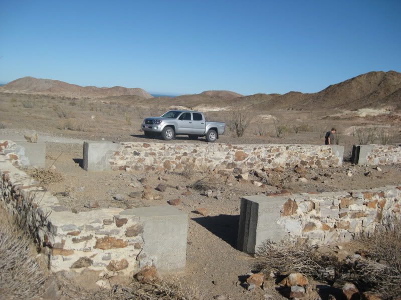
My next goal was to locate the remains of the Jesuit & Franciscan mission era warehouse built near the shore of the bay. We poked in several roads
leaving Papa's, but was successful on only one branch towards the bay.
Just south of the military checkpoint a road goes around the hill and leads to an abandoned fish camp, midway between Papa's and Alfonsina's on the
shore. West of the concrete slab at the end of that side road is an older rectangular ruined foundation. I believe that is the remains of the stone
structure mentioned in the 1958 (and later editions of the) 'Lower California Guidebook'. GPS: 29º48.91'/ 114º24.57'.
Mision Santa Maria, founded by the Jesuits in 1767 was supplied by shipments, off-loaded here. The Franciscan padres who soon replaced the Jesuits
continued to off-load supplies at Gonzaga Bay for their first California mission at San Fernando Velicata. Fr. Junipero Serra had a cargo trail built
to haul supplies to Santa Maria, as a more direct route than using the El Camino Real which is reached at the mouth of Santa Maria Canyon, south of
Gonzaga.
After finding the Jesuit warehouse ruins, I tried to imagine the cargo route up to Mision Santa Maria. Baja Bucko traveled it last year on muleback
almost to Gonzaga from Santa Ynez via Santa Maria. The year before, Bucko rode on the El Camino Real from El Crucero to Santa Maria, again on a mule!
------------------------------------------------------------------------
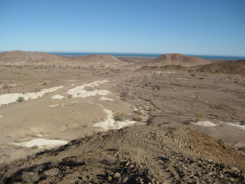
My next quest was the onyx or soda springs reported in a 1959 issue of Desert Magazine.
Gonzaga Bay was uninhabited back in 1959, and a long four wheel drive trail was the only way there. The white, mineralized slope is very visible from
the beach near Alfonsina's and from Rancho Grande. The article said it was 4 miles from the beach, and that was quite accurate. The article author and
her husband hiked all the way there. We chose to 'Toyota' and 'Kawasaki' all the way, or close! But which way?
Going south of Rancho Grande we took the first Jeep trail to the right, but that dead ended. The second trail did go several miles inland, but south
of the white hillside. It took us to a beautiful valley at the base of the lava mountain range. We turned north in this valley and drove cross country
(no shrubs, just grass) until we came to another Jeep trail. This may have been the route of Serra's Cargo Trail?
We did get to less than a mile from the white hillside, but I believed there was a closer approach. We returned to camp for a break in exploring, by
following this trail north. The trail took us right back to Rancho Grande, from behind!
When we returned for the next attempt to drive to the white, glacier-like slope we used that same trail, in reverse. Chris went up one side wash, to
the right, that looked promising. After a few minutes he rode back to where I could see him and waved frantically. He found the way in! In fact, some
rocks had letters marking the trail and near where the Toyota could go no further, red ribbons were tied to ocotillos marking a way to get close as
possible. The sight (1/4 mile) ahead was a white, mineralized waterfall, with a trickle of salty water flowing down. All around were several onyx
boulders, just like at El Marmol, but not quarried.
A climb up the waterfall and the huge whitened field, about 1500' by 1000' in size, was above. All this was surrounded by the dark lava mountainside.
The view of Gonzaga Bay was wonderful. Mineralized water trickles forth from several places in this white field.
For all the years I have been going to Gonzaga, that white slope never caught my attention. A 1959 Desert Magazine article sent to me by Mexray and
some emails by Punta Final resident and Baja book collector Norm Christie intrigued me to see this place for myself. Norm asked that visitors please
don't walk on the white crystal sheets. He also asked me not to publish GPS directions, which I always honor when a new special place is shared with
me. Baja explorers with respect for preserving the natural beauty can contact me if they need more details.
So, like me, you have some hints to go by. Have fun finding your own way to this amazing natural wonder in Mexico's magic peninsula!
--------------------------------------------------------------------------
In May of 1999, just months after discovering the Internet's many Baja web sites and the amigos here, Baja Mur met me and we went to Mision Santa
Maria from Rancho Santa Ynez (on a m/c and a quad). We returned to Santa Ynez at sundown, then loaded our rides and drove to Gonzaga Bay, staying at
Doug's casa (at Alfonsina's).
When the wind one day prevented us from fishing, we went up the Santa Maria Canyon to see how close we could ride, (then walk) towards the mission. We
found refreshing pools of water and took a swim, rather than hike any further.
On our last day of that trip, Doug took us over the canyon and mission in his plane for an aerial recon. All this can be seen on mine and Baja Mur's
web sites: http://vivabaja.com/missionsm
The gap between the mission and the canyon pools below is only about 5 miles (straight), but is so rugged, years of attempts by Rancho Santa Ynez to
build a road between the mission and Gonzaga were abandoned. The Mexican government even deemed it impossible and built the connecting road from
Laguna Chapala instead.
From the end of the bulldozed road, just east of the mission, an old trail descends to the canyon floor (can be seen in our aerial photos). This was
an Indian trail and Graham Mackintosh tried taking his burro down it... too rough!
The padres built their El Camino Real north of the rocky canyon, parallel to it. I knew the old camino east of the canyon went to Las Palmitas oasis.
But where did it cross the sandy Arroyo Santa Maria and ascend the mountain, to reach Mision Santa Maria? That was my next quest!
Friday afternoon, we headed south from the Pemex/Rancho Grande Store 7.4 miles to the Las Palmitas road going west at 29º41.09'/ 114º24.57'(NAD27).
Taking this road you will cross two large arroyos (Las Arrastras and Tomas, in the Almanac) and after three miles come to a steep long down grade to
the Santa Maria (dry river) valley.
At 3.2 miles or 29º41.28'/ 114º27.64' the greater traveled road forks south, but tracks also continue straight ahead towards the Santa Maria Canyon.
The south road goes through a beautiful desert gorge and ends in 1.5 miles at an oasis of 30 tall palms and more smaller ones around a full water
hole. This is Las Palmitas or as a sign spells it 'Las Palmytas' oasis at 29º40.35'/ 114º28.29'. The El Camino Real comes over the low rise (to the
east) from Calamajue, and either uses the route just driven on or goes over the hill to the Arroyo Santa Maria valley.
Back at the fork at Mile 3.2, continue west along the valley. Before reaching a point 4.0 miles from dirt Highway 5 or 0.8 mi. from the Las Palmitas
fork, is a parking spot by a huge boulder. The tracks ahead drop into the white sand arroyo, but rocks will soon block your way at 29º41.65'/
114º28.25'.
Turning around (4WD), you will see a set of tire tracks coming in from the left take this to the north bank of the arroyo. One can continue east from
here and drive all the way back to Highway 5. However, it's all very sandy for 5.6 miles. The Las Palmitas road is far easier.
We didn't find it that cloudy day... very disappointing! Saturday, the sun came out and we returned. With the sun shining bright, we could see a trail
as we neared the end of the road. It was climbing up from the arroyo to a side valley, above.
If you leave your vehicle at the huge boulder at the edge of the sandy arroyo, you can walk across the arroyo to the opposite side to find the El
Camino Real. You are near the mouth (or entrance) of the Santa Maria Canyon. Walking up the canyon (about a mile) will bring you to the blue palms and
pools Mur and I swam in, in 1999.
The north bank of the arroyo has about an 8 foot high cliff, so I was searching for some access that mules and people could climb up. I soon found it,
three northbound cattle trails converged, and that is where the El Camino Real leaves Arroyo Santa Maria, going north. A small granite boulder 'step'
marks the spot at 29º41.733'/ 114º28.175' (NAD27).
Following the cattle tracks, they go a short distance to a steep climb up the side of the valley, through some ocotillos. This would be difficult on a
motorcycle, but has been done on a XR600, per a letter I received. The trail beyond turns from north to northwest. Along here, a sign was laying on
the ground with 'Mission Santa Maria' and arrows painted on it. Baja Bucko (who rode a mule here 2 years ago) told me about the sign. I was now
confirmed to be on the El Camino Real!
I walked about a mile, and was smiling from ear to ear the whole time. Chris elected to wait by my truck, otherwise I may have walked all the way to
the mission! This was a great day for me. I felt like I was in a place I belonged, it was very special for me. This cattle path of today was once the
main highway through Baja, before automobiles. Junipero Serra, Arthur North, and Harry Crosby had all been on this path before me.
Who will join me on a hike all the way to the mission? (The point where I turned back was at 29º42.374'/ 114º28.566')
With all my planned quests met, I was a very satisfied explorer. We had a nice camp fire that night and were joined by John Baretta, Heather, and
John's kids.
We left at 8:30, Sunday morning, for the trip home. Passed Puertecitos at 10:30, San Felipe at noon, Mexicali at 2:15... and Calexico at 4:15! That 3
mile line took as long as the 50 mile rough road from Gonzaga to Puertecitos! We were home by 7:15... lots of traffic from Glamis on I-8.
Until the next Baja adventure... be good to yourselves and your fellow Baja Nomads and Amigos! Happy Holidays!
Photos of this trip begin at http://vivabaja.com/1102/page2.html
|
|
|
nbacc
Senior Nomad
Posts: 770
Registered: 12-27-2008
Location: Northern California
Member Is Offline
|
|
Don't miss the hot springs........it is pretty unique. Nancy
|
|
|
| Pages:
1
2 |
|


