| Pages:
1
2
3 |
wilderone
Ultra Nomad

Posts: 3915
Registered: 2-9-2004
Member Is Offline
|
|
IMO, 7 days in Baja isn't very long to do the entire peninsula. The days will be short in February - sunset probably around 6 pm, and you will need to
be at some hotel or B&B at the end of the day. There's plenty to see en route that won't take up a lot of time going to and fro, will get you out
of the car, and allow you to experience a sampling of Baja.
You asked about crossing in Mexicali in order to go to Gonzaga and out Hwy 1, passing Coco's. That's a trip better left when you have more time, IMO.
Cross in Tecate, stop at a couple wineries, on Mex. 3. Stop for lunch in Ensenada; buy some groceries at the CaliMex or Gigante stores. Visit the
Mision de San Vicente Ferrer; drive about a mile off road when you get to the boulder gardens at Catavina and hike around, see the rock art there.
It's an easy drive to Bahia de los Angeles - do that. Defintely time your trip so you can drive out to Scammons and see the whales there (or stay in
Guerrero Negro and sign up for a bus trip in town). Buy honey in Vizcaino. Doing an off-road section via Asuncion/La Bocana/Abreojos would also be
time consuming and a lot of in-the-car hours. Get to Mulege and take a couple days there. At this point, you'd only have 3 days left.
Seewhatimtalkinabout?
|
|
|
honda tom
Nomad
Posts: 493
Registered: 8-28-2003
Location: middle calif
Member Is Offline
|
|
IMO you will have a more relaxing time by crossing at Mexicali and driving through San Felipe and onto Gonzaga the first night. This way the next
morning you can cross the "visit cocos" off your list. BOLA is only 3 hours from Gonzaga, and you could decide to stay or continue to San
Francisquito (here you will be nearly alone with a hut or palapa and a beautiful beach). then continy=ue the next day to Mulege. You will not need 4X4
and food and fuel is readily available on your route. I beleive this is the most bang for your buck for a trip south. Hwy 1 from TJ south is not
much to enjoy for the first 5 hours.
|
|
|
Jaybo
Nomad
Posts: 240
Registered: 12-7-2009
Location: NW Oregon
Member Is Offline
Mood: Praying for Baja!
|
|
Is there any current maps of what is and is not paved?
|
|
|
wsdunc
Nomad
Posts: 179
Registered: 8-24-2006
Location: So Cal
Member Is Offline
Mood: Upbeat
|
|
I second the idea of whale watching at Ojo de Liebre lagoon, Shari can tell you all about it. When near Mulege think about checking out Punta
Chivato, I think it is one of the most beautiful places in Baja
|
|
|
David K
Honored Nomad
Posts: 65590
Registered: 8-30-2002
Location: San Diego County
Member Is Offline
Mood: Have Baja Fever
|
|
| Quote: | Originally posted by Jaybo
Is there any current maps of what is and is not paved? |
No... unless I (or another) make you one. The only Federal Highway unpaved in Baja (I can think of) is Mex. 5. Last July the pavement ended 31 miles
south of Puertecitos/ 10 miles north of Papa Fernandez' road... and they were ready to open more miles very soon. Road and bridge construction lasted
up to Papa's road with a well graded dirt detour alongside.
Papa's to Hwy. 1 at Chapala is about 38 miles, and it is easy to drive in 2WD, but the surface is rough, so slow going for most.
Other roads paved since the last AAA map was made include:
Hwy. 1 to Observatory San Pedro Martir (62 miles)
Hwy. 1 to Bahia Asuncion (70 miles) some repaving going on.*
Hwy. 1 to Punta Abreojos (65 miles)
Hwy. 1 to San Francisco de la Sierra (only partly paved)
Hwy. 1 to Laguna San Ignacio (only partly paved)
Hwy. 1 to Geothermal Plant Las Tres Virgenes.
* See today's paving post with photos: http://forums.bajanomad.com/viewthread.php?tid=64428
[Edited on 12-13-2012 by David K]
|
|
|
Jaybo
Nomad
Posts: 240
Registered: 12-7-2009
Location: NW Oregon
Member Is Offline
Mood: Praying for Baja!
|
|
David, Thank you. I'll mark the hwy 5 info in my almanac. I'm starting to like the idea of going down 5 perhaps all the way to Alfonsina's the first
day if that is doable. It looks beautiful. If I didn't go down from Mexicali and went via Hwy 3 instead any pro's and con's on that? I'm just
concerned about the time to go across To Mexicali .. or would it actually take longer because of all of the cities?
|
|
|
David K
Honored Nomad
Posts: 65590
Registered: 8-30-2002
Location: San Diego County
Member Is Offline
Mood: Have Baja Fever
|
|
We cross at Tecate or Mexicali to go to San Felipe. Tecate east on 2-D avoids Mexicali city streets. On the Almanac, pavement ended 1 km north of
Delfines road but paving was near ready to Papa Fernandez' road. Mexicali is easy to cross if you do the border southbound there.
|
|
|
Marc
Ultra Nomad
Posts: 2802
Registered: 5-15-2010
Location: San Francisco & Palm Springs
Member Is Offline
Mood: Waiting
|
|
Mex5 gets you to Gonzaga and then Coco's on the way to Mex1 and south the BOLA turn off. I prefer this route over Mex1 from Ensenada. BTW
Alfonsina's in Gonzaga tends to fill up on weekends.
I find DK's maps valuable. I used one of his hand drawn maps recently to explore one of the canyons at Gonzaga.
|
|
|
captkw
Ultra Nomad
Posts: 3850
Registered: 10-19-2010
Location: el charro b.c.s.
Member Is Offline
Mood: new dog/missing the old 1
|
|
7 day road guero
thats a fast and short trip in 7 days...BTW baja looks a lot smaller on a map than in real life !!!! K&T
|
|
|
Jaybo
Nomad
Posts: 240
Registered: 12-7-2009
Location: NW Oregon
Member Is Offline
Mood: Praying for Baja!
|
|
kw - That's the beauty of it, 7 days is a target - We will be down there for 24 days total, so if we are a couple days late getting to SJDC the sky
wont fall on us  I guess I should have mentioned that. I guess I should have mentioned that.
David - any time advantage of crossing at Tecate and taking 2-D vs. taking I-8 to Mexicali? Wife is concerned about excess time spent in the border
region as well since that is where the "problems" are ..
|
|
|
Marc
Ultra Nomad
Posts: 2802
Registered: 5-15-2010
Location: San Francisco & Palm Springs
Member Is Offline
Mood: Waiting
|
|
Crossing southbound is never a problem anywhere. Crossing NORTH, big problem.
|
|
|
honda tom
Nomad
Posts: 493
Registered: 8-28-2003
Location: middle calif
Member Is Offline
|
|
I would drive out to el centro ca, then cross at calexico. 10 minutes of mexicali and your in the countryside, then its 2 hours to san felipe for a
taco, and less than 3 hours to alfonsinas. all but the last 15 minutes of this day is paved. Weekday no problem getting room, in Feb. I dont think it
will be a problem on weekend either. Sometimes he likes to tell you hes all full, but keep pressing him and he always comes up with one more room, (it
makes you feel special).
From alfonsinas (gonzaga) to coco's is smooth dirt, then a rough patch of rocks(but still no problem for any vehicle driven slowly) then smooth dirt
again, plan 45 minutes to cocos.
From coco to hwy 1 is rough and rocky (just go slow for 1 hour) .
hwy 1 to bola is all paved and about 1.5 hours.
I like BOLA, but mostly just for lunch because you are only 80 miles from san francisquito. 2.5 hours of fun desert road, to a isolated beach wit
cabanas, or palapas. bring sleeping bags (they have cots) get food at a market in BOLA for backup, but they will cook fish or beef for you 95% of the
time. 20 bucs a head to sleep under cover with sides, or 8 bucs for a open palapa. Dont plan on hot water 75% of the time.... but for me its the
atmosphere. get gas at BOLA and you will have range to Viscaino.
|
|
|
Jaybo
Nomad
Posts: 240
Registered: 12-7-2009
Location: NW Oregon
Member Is Offline
Mood: Praying for Baja!
|
|
Tom, I am thinking exactly that in regards to Alfonsina's the first day. The hard part for us, is where we stay for the extra day or two on the way
down. We would be coming in there on a Sunday afternoon so not worried about rooms.
We also want to see BOLA but we would stay in a hotel - Wife says she is not ready to camp yet , and room for camp stuff will be at a premium. From
there its off to I think Asuncion. Whale trip sounds like a must do as well. extra day there? From there to Mulege and see that area and maybe a
couple days there?
We have a stop in LaPaz to make, and one in Los Barrillesbefore heading to SJDC. We'll be there for 2 weeks so if we are a day or 2 late it is not a
big deal.
What kind of Honda?
|
|
|
Jaybo
Nomad
Posts: 240
Registered: 12-7-2009
Location: NW Oregon
Member Is Offline
Mood: Praying for Baja!
|
|
| Quote: | Originally posted by Marc
Crossing southbound is never a problem anywhere. Crossing NORTH, big problem. |
Yeah, for that part Glad we are flying back
|
|
|
honda tom
Nomad
Posts: 493
Registered: 8-28-2003
Location: middle calif
Member Is Offline
|
|
BOLA has plenty of hotels 25-55 bucs. Because of short drive from Gonzaga to BOLA youll have plenty of time to see it. There is also a small musuem.
on the BOLA hwy.... 13 miles west of BOLA is the turnoff to mission san borja. about a 1 hour dirt road to a cool mission you can walk through the
entire thing. the family that lives there is restoring it. just a thought if your into that kind of thing.
From BOLA I would still take the dirt to Viscaino (mostly cause i like dirt roads). Cross the road and your on your way to Asuncion.
[Edited on 12-14-2012 by honda tom]
|
|
|
honda tom
Nomad
Posts: 493
Registered: 8-28-2003
Location: middle calif
Member Is Offline
|
|
XR 400 with over 12,000 miles of baja dirt
|
|
|
Jaybo
Nomad
Posts: 240
Registered: 12-7-2009
Location: NW Oregon
Member Is Offline
Mood: Praying for Baja!
|
|
Tom, The Almanac is not very clear as far as which road is going to Viscaino - seems to be lots of them. I am a bit concerned about that much dirt
on a vehicle I don't own. David, do you have a chunk of map of that area that is more clear than the Almanac?
|
|
|
David K
Honored Nomad
Posts: 65590
Registered: 8-30-2002
Location: San Diego County
Member Is Offline
Mood: Have Baja Fever
|
|
| Quote: | Originally posted by Jaybo
Tom, The Almanac is not very clear as far as which road is going to Viscaino - seems to be lots of them. I am a bit concerned about that much dirt
on a vehicle I don't own. David, do you have a chunk of map of that area that is more clear than the Almanac? |
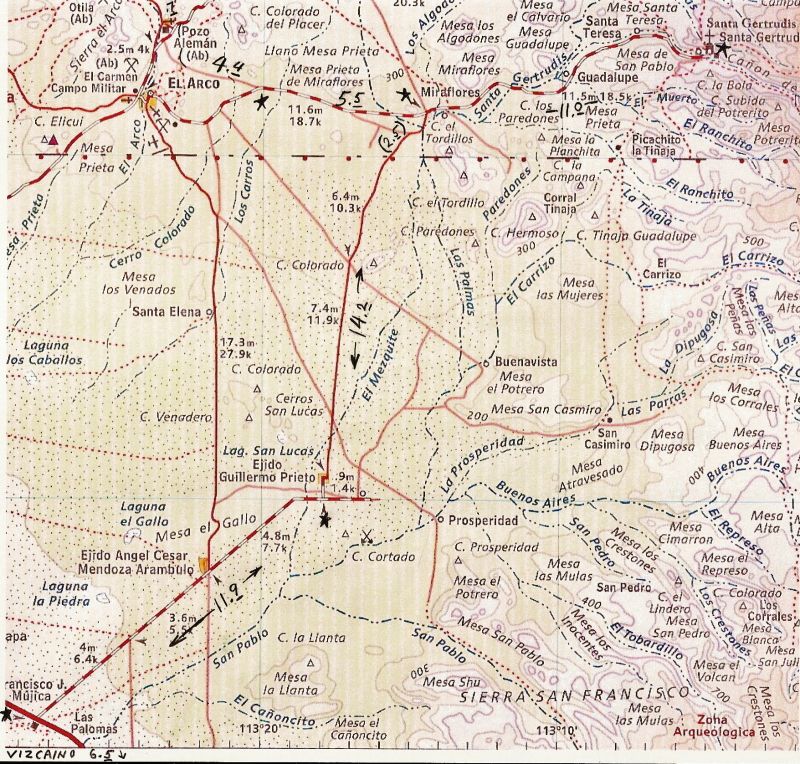
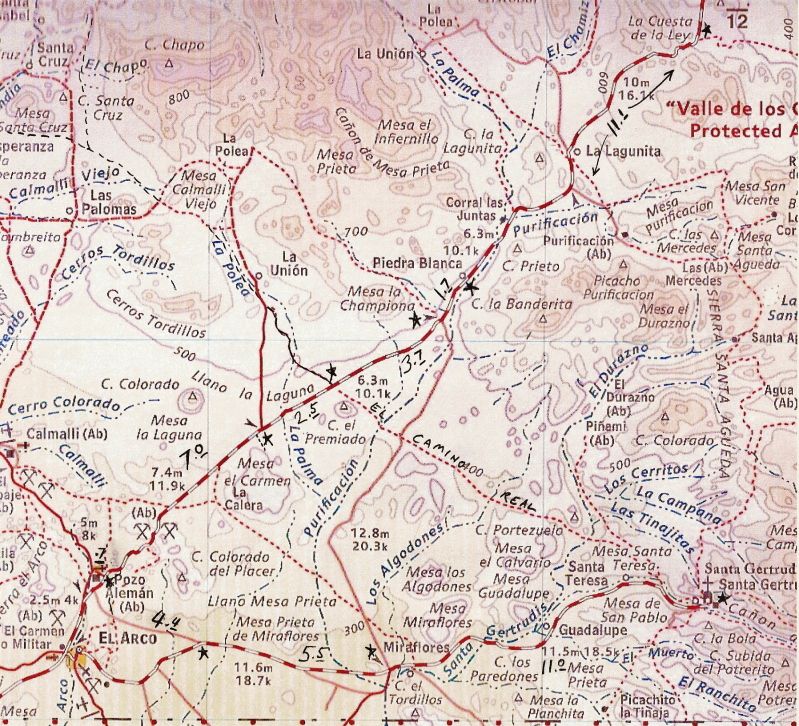
The following are AAA map portions with an unmapped road drawn in, that I first drove on in 2001 and has also been used for the Baja 1000 (not this
last one)... it is 2WD and was graded... signed for Mision Santa Gertrudis, which is 11 miles off to the east from it. Obviously, rain can affect the
road.. and the village of Guillermo Prieto was abandoned on our last time through (last July).:
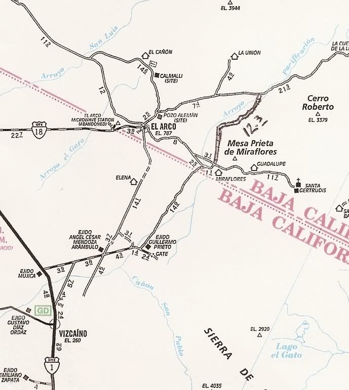
The new Baja Almanac does have this road... and it is surprising that the Auto Club neglected to add the north half of it in, but it was there when
they added the south half of it.
|
|
|
David K
Honored Nomad
Posts: 65590
Registered: 8-30-2002
Location: San Diego County
Member Is Offline
Mood: Have Baja Fever
|
|
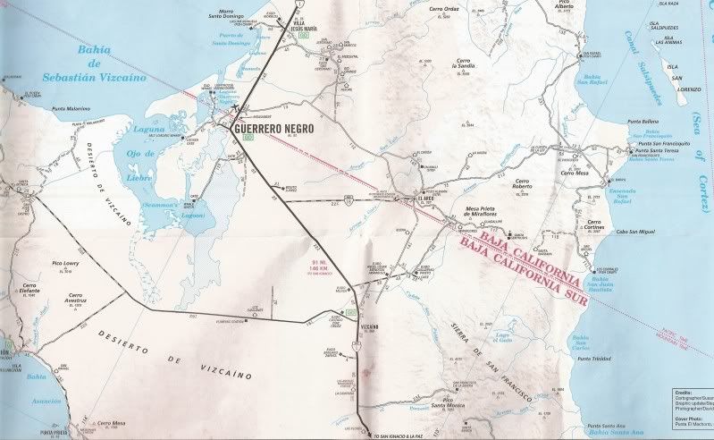
This was my route last July... we diverted over to the El Arco road from Santa Gertrudis to see Pozo Grande and the giant cave art of El Carmen near
the La Union ranch road... http://www.bajabound.com/bajatravel/painted_cave_of_el_carme...
AAA Map and Baja Almanac map with my travel notes added:
[Edited on 12-14-2012 by David K]
|
|
|
Jaybo
Nomad
Posts: 240
Registered: 12-7-2009
Location: NW Oregon
Member Is Offline
Mood: Praying for Baja!
|
|
David, Wow, Thank you so much, that's really helpful! My only concern of course is it not being my vehicle, and the condition of the roads. I'll have
to really think on that and perhaps adjust when we are there ....
|
|
|
| Pages:
1
2
3 |