| Pages:
1
2 |
TMW
Select Nomad
      
Posts: 10659
Registered: 9-1-2003
Location: Bakersfield, CA
Member Is Offline
|
|
Gonzaga to Chapala
From a friend in San Felipe:
Chatted with the head dood from SIDUE (Baja’s version of CalTrans) yesterday. He told me the new federal administration has committed all the funds to
complete the construction of highway 5 between Gonzaga and Chapala. Construction will begin soon and completion of all phases approximately 3 years …
end of 2015.
|
|
|
David K
Honored Nomad
        
Posts: 65436
Registered: 8-30-2002
Location: San Diego County
Member Is Offline
Mood: Have Baja Fever
|
|
That does it... 
All the semi trucks will be short cutting to Mexicali that way.
Tom, next time you talk to him, ask about a new highway between San Felipe and Puertecitos. All those steep vados will do a number on the
tractor-trailer rigs.
In the past it was reported a new, state-of-the-art style highway would fill in the void and go along the older road to Puertecitos (via the sulfur
mine).
[Edited on 2-1-2013 by David K]
|
|
|
TMW
Select Nomad
      
Posts: 10659
Registered: 9-1-2003
Location: Bakersfield, CA
Member Is Offline
|
|
He said there was no funds for a bypass of San Felipe. I'll ask about the vados.
|
|
|
David K
Honored Nomad
        
Posts: 65436
Registered: 8-30-2002
Location: San Diego County
Member Is Offline
Mood: Have Baja Fever
|
|
You have a 110 kph, new style, wide highway north of San Felipe and south of Puertecitos. In between those two towns in 52 mils of narrow, deep/ steep
angled dips, old style highway. Can you picture what will happen when the giant semis high center on one of them, or a passenger car hits one at the
speed the rest of the highways allow?

|
|
|
redhilltown
Super Nomad
   
Posts: 1130
Registered: 1-24-2009
Location: Long Beach, CA
Member Is Offline
|
|
DK is sooooo right about this one. That stretch of highway has minimal construction at best...it will be torn to pieces by heavy traffic not to
mention what mother nature might do.
Just a bit odd that they started in Puertecitos and not outside of San Felipe.
|
|
|
David K
Honored Nomad
        
Posts: 65436
Registered: 8-30-2002
Location: San Diego County
Member Is Offline
Mood: Have Baja Fever
|
|
| Quote: | Originally posted by redhilltown
DK is sooooo right about this one. That stretch of highway has minimal construction at best...it will be torn to pieces by heavy traffic not to
mention what mother nature might do.
Just a bit odd that they started in Puertecitos and not outside of San Felipe. |
The contractor that paved the San Felipe to Puertecitos road went to jail, the story goes...
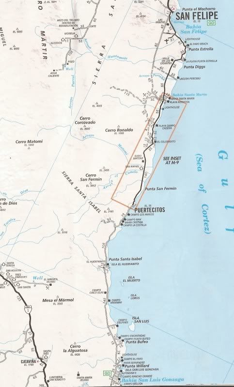
The roadbed (graded dirt) was built in 1982... so being dirt, the short steep vados were no big deal, as we weren't going 50 mph on it.
Many years later they got funds to pave it, and that took a while... getting to Puertecitos by 1996. Just 4 year more, the pavement was full of holes
and the last 10 miles was mostly gone. It would be 10 years before the entire job was repaved... by 2007.
The contractor put just enough asphalt down to make it look paved... and the government inspector never cored the highway to verify the thickness of
the pavement... in fact, he didn't even drive it (the steep vados would be an issue), he took a plane and looked down to see the blacktop reached
Puertecitos, it had... so the final payment was made!
|
|
|
TMW
Select Nomad
      
Posts: 10659
Registered: 9-1-2003
Location: Bakersfield, CA
Member Is Offline
|
|
We raced the 87 1000 and it was a graded road coming out of Matomi wash. At the 88 1000 it was paved but as DK said it was minimum. When the pot holes
started to show, which was soon, the asphalt was only 1/4 inch think in many places.
|
|
|
David K
Honored Nomad
        
Posts: 65436
Registered: 8-30-2002
Location: San Diego County
Member Is Offline
Mood: Have Baja Fever
|
|
| Quote: | Originally posted by TW
We raced the 87 1000 and it was a graded road coming out of Matomi wash. At the 88 1000 it was paved but as DK said it was minimum. When the pot holes
started to show, which was soon, the asphalt was only 1/4 inch think in many places. |
Thanks TW, I yield to your first hand report!... During the time of babies 1988-2002, we didn't make many Baja trips, '87 we went to Gonzaga on the
new roadbed... but it was dirt...
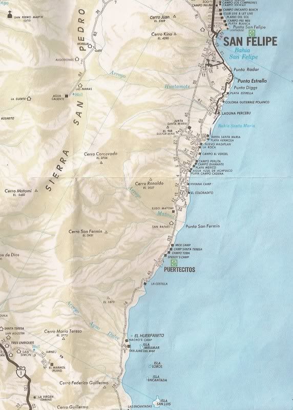
For my comments above, I was going by the AAA maps, which were annually updated back then, and the 1989 and 1990 map shows the pavement ending at the
Laguna Percebu junction and the rest of the road to Puertecitos as gravel/ ready for paving. The '89 map did pave over the wrong road to Percebu!
Here are some of the Auto Club of So. Cal maps:
1987:
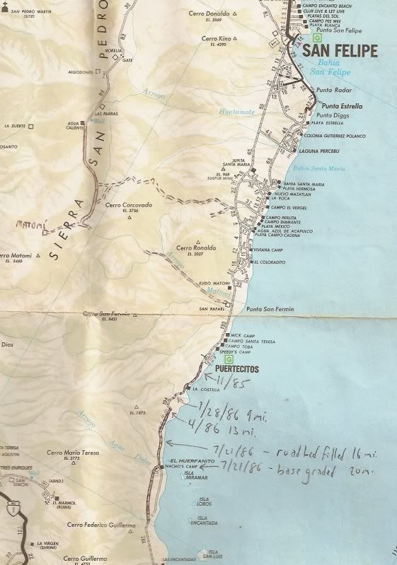
The notes I penciled in are pointing to the end of new roadbed construction with dates.
1989:
1990:
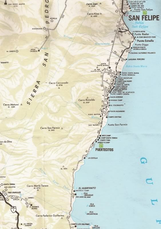
1996:
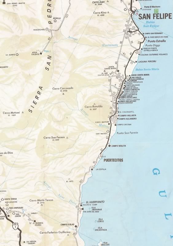
1997:
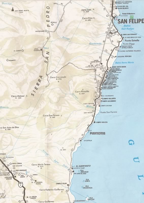
2000:
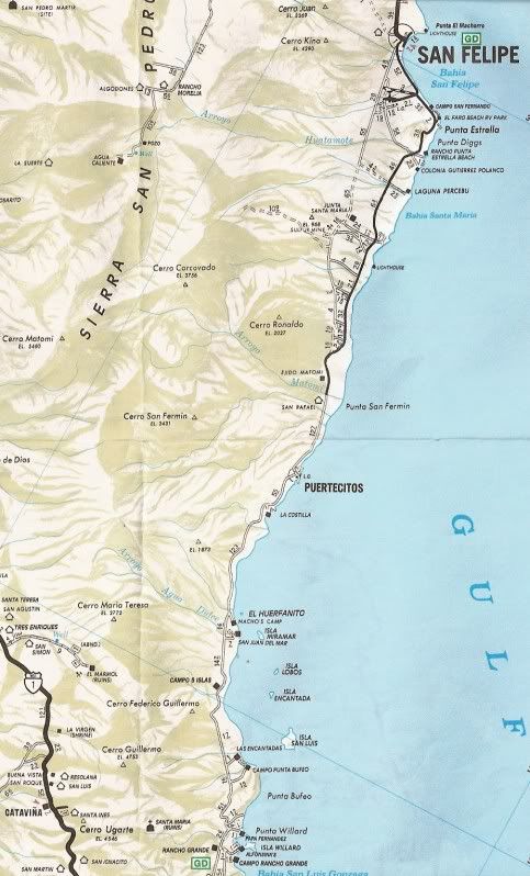
2001:
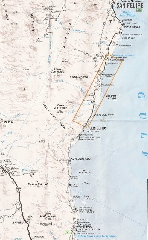
2004:
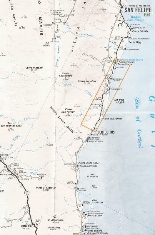
2007:
[Edited on 2-4-2013 by David K]
|
|
|
PYandre
Newbie
Posts: 8
Registered: 11-23-2006
Member Is Offline
|
|
Chapala-Gonzago road passable w/trailer????
I'm heading north from Loreto pulling a 21' Airstream with my Ford Excursion and am wondering if the road from Chapala to Gonzago Bay is passable with
a travel trailer. Has anyone driven it since the last hurricane (i.e. last fall 2012)?
|
|
|
David K
Honored Nomad
        
Posts: 65436
Registered: 8-30-2002
Location: San Diego County
Member Is Offline
Mood: Have Baja Fever
|
|
The 38 unpaved miles from Chapala to pavement near Papa Fernandez' will shake up a trailer real good... So be prep'ed for that and also going maybe 10
mph for those miles...?
|
|
|
RnR
Senior Nomad
  
Posts: 839
Registered: 5-1-2010
Member Is Offline
|
|
| Quote: | Originally posted by David K
The 38 unpaved miles from Chapala to pavement near Papa Fernandez' will shake up a trailer real good... So be prep'ed for that and also going maybe 10
mph for those miles...? |
The road is doable for the trailer but it will probably never be the same afterwards. An Airstream is an expensive rig to beat up on that road!
|
|
|
PYandre
Newbie
Posts: 8
Registered: 11-23-2006
Member Is Offline
|
|
When was the last time you drove the road?
|
|
|
David K
Honored Nomad
        
Posts: 65436
Registered: 8-30-2002
Location: San Diego County
Member Is Offline
Mood: Have Baja Fever
|
|
I drove it last July, and since then, 10 more miles of pavement was opened per Nomad bbbait who showed us photos of the end by the new big bridge just
north of Papa Fernandez' road. The miles from Gonzaga to Chapala were not freshly graded and slower than years past... lots of small sharp rocks to
flatten tires!
|
|
|
tripledigitken
Ultra Nomad
    
Posts: 4848
Registered: 9-27-2006
Member Is Offline
|
|
| Quote: | Originally posted by PYandre
I'm heading north from Loreto pulling a 21' Airstream with my Ford Excursion and am wondering if the road from Chapala to Gonzago Bay is passable with
a travel trailer. Has anyone driven it since the last hurricane (i.e. last fall 2012)? |
I drove it a month ago. Yes the road is "passable" with your rig, but I wouldn't put an Airstream through the abuse. We saw someone heading south by
Coco's pulling a 2 axle utility trailer loaded 8' high with building materials and appliances. We just wondered is the risk/reward of taking that rig
over that road worth it. To them it was.
Ken
|
|
|
dizzyspots
Senior Nomad
  
Posts: 603
Registered: 9-22-2008
Location: Mescal AZ
Member Is Offline
Mood: rather be on the beach at Gonzaga
|
|
We went to see Coco last November...not too bad...washboard and a couple of washout areas on northside thru the "rock garden"...didnt go past Coco's
|
|
|
PYandre
Newbie
Posts: 8
Registered: 11-23-2006
Member Is Offline
|
|
Thanks to all! I've decided not to try to pull the trailer through. I hope to return in a month without the trailer and then I will try it with just
my car and no trailer. I think I'll check out Asuncion and Santa Rosallita instead this time.
|
|
|
micah202
Super Nomad
   
Posts: 1615
Registered: 1-19-2011
Location: vancouver,BC
Member Is Offline
|
|
...as of a few weeks ago the road from a few miles before GonzagaBay on south is mucho washboardo through to the #1,,,going by observations and
reports.
.....some travelers from the south looked downright -shaken- by their experiences!!
.......it's so funny how the stretch between Puerticitos and Gonzaga is equal to the BEST paved highway I've seen in Baja,,,even has paved sidewalks
and big pullouts in the middle of no-where......
........while the SanFelipe to Puerticitos stretch has some of the nasty-est dips around,,,some unmarked 
|
|
|
David K
Honored Nomad
        
Posts: 65436
Registered: 8-30-2002
Location: San Diego County
Member Is Offline
Mood: Have Baja Fever
|
|
Yup, Hwy. 5 has all phases of work on it:
4 lanes out of Mexicali for about 30 miles, then 2 lanes of old and new style (old is narrow vs. the newer style that is wide with bike lanes on each
side, or wide shoulders). They are rebuilding the old into new in the middle section now.
Then back to 4 lanes for the final 20 miles into San Felipe...
Then once off the airport road, you got old style narrow pavement and steep dips for the run to Puertecitos (52 miles from SF). This is where you get
back to the new, wide, modern style highway built the past 7 years to the edge of Gonzaga where the pavement ends and you have a government graded
dirt highway with rocks and washboard for the last 38 miles to Laguna Chapala (Hwy. 1).
|
|
|
PYandre
Newbie
Posts: 8
Registered: 11-23-2006
Member Is Offline
|
|
I just received this email today (3/12/13) from friends who drove from Chapala to Coco's Corners to San Felipe yesterday:
The road from Chapala to Gonzaga is quite rough, especially the 20km section between Coco's Corner and Chapala (Hwy 1). However, we felt it was well
worth it. We went slow to Coco's Corner but even then it took less than an hour. And the section between Coco's Corner and Gonzaga (almost 40 km) was
a lot easier, especially with some side sand roads which were easy to drive. The whole 60 km took about 2 hours, and that includes the obligatory beer
stop at Coco's Corner.
We stopped at Alfonsina's in Gonzaga Bay -- very pretty but decided to go on to San Felipe for the night. The road is paved almost all the way from
Gonzaga to San Felipe and it is a beautiful drive along the Sea of Cortez (except for the tacky little developments along the way). The only thing to
watch out for are the vados between San Felipe and Puertocitos -- a 70 km stretch or so. YOU HAVE TO SLOW DOWN FOR THEM, unless you want to really
shake things up in the car.
The advice you got on Baja Nomad about pulling a trailer over this sections was very good. I wouldn't want to pull between Chapala and Gonzaga. We met
one fellow who was doing that and he was fine, but said it was taking a long time.
|
|
|
David K
Honored Nomad
        
Posts: 65436
Registered: 8-30-2002
Location: San Diego County
Member Is Offline
Mood: Have Baja Fever
|
|
| Quote: | Originally posted by PYandre
I just received this email today (3/12/13) from friends who drove from Chapala to Coco's Corners to San Felipe yesterday:
The road from Chapala to Gonzaga is quite rough, especially the 20km section between Coco's Corner and Chapala (Hwy 1). However, we felt it was well
worth it. We went slow to Coco's Corner but even then it took less than an hour. And the section between Coco's Corner and Gonzaga (almost 40 km) was
a lot easier, especially with some side sand roads which were easy to drive. The whole 60 km took about 2 hours, and that includes the obligatory beer
stop at Coco's Corner.
We stopped at Alfonsina's in Gonzaga Bay -- very pretty but decided to go on to San Felipe for the night. The road is paved almost all the way from
Gonzaga to San Felipe and it is a beautiful drive along the Sea of Cortez (except for the tacky little developments along the way). The only thing to
watch out for are the vados between San Felipe and Puertocitos -- a 70 km stretch or so. YOU HAVE TO SLOW DOWN FOR THEM, unless you want to really
shake things up in the car.
The advice you got on Baja Nomad about pulling a trailer over this sections was very good. I wouldn't want to pull between Chapala and Gonzaga. We met
one fellow who was doing that and he was fine, but said it was taking a long time. |
Did you see the photo above? That was painted on Hwy. 5 for many years near a dip close to Punta Estrella (Valley of the Giants area).
|
|
|
| Pages:
1
2 |

