| Pages:
1
2 |
PaulW
Ultra Nomad

Posts: 3113
Registered: 5-21-2013
Member Is Offline
|
|
Tule Canyon
What is the story? I find reference by Coral Pepper and Bruce Barber and both agree that Tule is in the general area of Jaquegel/Pole Line as viewed
from the Arroyo Grande area.
My search has found lots of places with Tule in the name, but none are anywhere near the place either mentioned.
Seems like the name has been lost ofver time?
Maybe someone with old maps can help?
Thanks, PaulW
|
|
|
Barry A.
Select Nomad
Posts: 10007
Registered: 11-30-2003
Location: Redding, Northern CA
Member Is Offline
Mood: optimistic
|
|
I just checked my Mexican Govt. Topo maps of that area, and I can't find any "Tule" canyon or wash. That name sure rings a bell with me, but I am
stumped for now.
Barry
|
|
|
Barry A.
Select Nomad
Posts: 10007
Registered: 11-30-2003
Location: Redding, Northern CA
Member Is Offline
Mood: optimistic
|
|
I also checked Gulick and Gerhard's BAJA CA GUIDE BOOK copyright 1964 and they don't show a "Tule" canyon or wash in that area either as far as I can
tell, and they are pretty detailed in their treatment of that area.
Barry
|
|
|
mtgoat666
Platinum Nomad
Posts: 21162
Registered: 9-16-2006
Location: San Diego
Member Is Offline
Mood: Hot n spicy
|
|
| Quote: | Originally posted by PaulW
What is the story? I find reference by Coral Pepper and Bruce Barber and both agree that Tule is in the general area of Jaquegel/Pole Line as viewed
from the Arroyo Grande area.
My search has found lots of places with Tule in the name, but none are anywhere near the place either mentioned.
Seems like the name has been lost ofver time?
Maybe someone with old maps can help?
Thanks, PaulW |
I think "tule" in the old California colony days was a word for low, swampy land or grass lands,... so maybe that can narrow down your review of
maps,...
tule makes me think of tule river or tule fog
|
|
|
Barry A.
Select Nomad
Posts: 10007
Registered: 11-30-2003
Location: Redding, Northern CA
Member Is Offline
Mood: optimistic
|
|
There is a "Tule Wash" in Anza-Borrego St. Park (USA), or more precisely in the Ocatillo Wells ORV Area, running west to east towards the Salton Sea
beside the "Pumpkin Patch". I think that is what I thought of when I knew I had heard "Tule Wash".
Barry
|
|
|
Mexitron
Ultra Nomad
Posts: 3397
Registered: 9-21-2003
Location: Fort Worth, Texas
Member Is Offline
Mood: Happy!
|
|
Possibly Carrizo Canyon? Carrizo means reed, tule is a reed.
|
|
|
David K
Honored Nomad
Posts: 65590
Registered: 8-30-2002
Location: San Diego County
Member Is Offline
Mood: Have Baja Fever
|
|
Hi guys, I am out of town so not easy for me to post the old maps that use the name Tule. It is the wash used by the Pole Line Road and the region of
the Lost Diaz Grave. Search my posts for Pole Line Road. The new name is Jaquegel. sorry but posting from my phone isn't easy for me. When I am back
home I will add details. You guys might figure it out with what I could type. See http://choralpepper.com also!
[Edited on 6-6-2013 by David K]
|
|
|
David K
Honored Nomad
Posts: 65590
Registered: 8-30-2002
Location: San Diego County
Member Is Offline
Mood: Have Baja Fever
|
|
Tule wash was also the name of Arroyo el Volcan (near El Marmol) used in the early 1900's maps. I think Walter Henderson used the name Tule for Arroyo
Jaquegel when he hiked towards it in the 1930's.
|
|
|
PaulW
Ultra Nomad
Posts: 3113
Registered: 5-21-2013
Member Is Offline
|
|
Tule
Super. Thanks DavidK.
With all the discussion about the Pole line Road I knew there would be more info.
Please post the map when you get a chance.
Thanks, PaulW
|
|
|
David K
Honored Nomad
Posts: 65590
Registered: 8-30-2002
Location: San Diego County
Member Is Offline
Mood: Have Baja Fever
|
|
Sure thing but I did not see Tule (the one off Arroyo Grande) on either the 1941 or 1930 maps. I suggest you read my threads on the Lost Diaz Grave
including the newest version that Choral Pepper wrote that was going into her never published edition. Bruce Barber worked off her earlier versions
and sadly had the wrong starting point for Walter Henderson's hike.
|
|
|
PaulW
Ultra Nomad
Posts: 3113
Registered: 5-21-2013
Member Is Offline
|
|
| Quote: | Originally posted by David K
Sure thing but I did not see Tule (the one off Arroyo Grande) on either the 1941 or 1930 maps. I suggest you read my threads on the Lost Diaz Grave
including the newest version that Choral Pepper wrote that was going into her never published edition. Bruce Barber worked off her earlier versions
and sadly had the wrong starting point for Walter Henderson's hike. |
====
So far the Coral Diaz article and discussions with Bruce are the only leads I have. Bruce has been helping me for quite a time. Tule could be anywhere
west of La Ventana.
Either N or S on the east slope of the mountains. Sure would like to drive from La Ventana west over the mountains. Maybe next winter?
have you got a link to the never published edition?
PaulW
|
|
|
David K
Honored Nomad
Posts: 65590
Registered: 8-30-2002
Location: San Diego County
Member Is Offline
Mood: Have Baja Fever
|
|
| Quote: | Originally posted by PaulW
| Quote: | Originally posted by David K
Sure thing but I did not see Tule (the one off Arroyo Grande) on either the 1941 or 1930 maps. I suggest you read my threads on the Lost Diaz Grave
including the newest version that Choral Pepper wrote that was going into her never published edition. Bruce Barber worked off her earlier versions
and sadly had the wrong starting point for Walter Henderson's hike. |
====
So far the Coral Diaz article and discussions with Bruce are the only leads I have. Bruce has been helping me for quite a time. Tule could be anywhere
west of La Ventana.
Either N or S on the east slope of the mountains. Sure would like to drive from La Ventana west over the mountains. Maybe next winter?
have you got a link to the never published edition?
PaulW |
It is here on Nomad... use the search link at top of page. As for the Pole Line Road, see Ken Cooke's recent posts. The Baja 500 used parts of the
road last week. I have given Bruce details on the Diaz grave in hopes he was still searching. That was many years ago. You can go west from La Ventana
then south in Arroyo Grande to the road and take it west but don't go it alone. Ken will add his knowledge...
|
|
|
TMW
Select Nomad
Posts: 10659
Registered: 9-1-2003
Location: Bakersfield, CA
Member Is Offline
|
|
Arroyo El Tule is shown in the newest almanac on page 2 at the bottom to the left of K and on page 3 at the top under K. This originally from DKs trip
report in 2003 or 4 where he went down El Mono.
|
|
|
TMW
Select Nomad
Posts: 10659
Registered: 9-1-2003
Location: Bakersfield, CA
Member Is Offline
|
|
If you want to go from La Ventana west over the mtns following the Pole Line road you would go up the summit (part of the SCORE race course) and come
by way of El Jamau, almanac page 3 L1.5 and down to hwy 3 at KM108, almanac page 3 K2.5, is the easiest route other wise you would go out by way of
Santa Catarina on a much rougher road, read whoops.
|
|
|
PaulW
Ultra Nomad
Posts: 3113
Registered: 5-21-2013
Member Is Offline
|
|
| Quote: | Originally posted by TW
If you want to go from La Ventana west over the mtns following the Pole Line road you would go up the summit (part of the SCORE race course) and come
by way of El Jamau, almanac page 3 L1.5 and down to hwy 3 at KM108, almanac page 3 K2.5, is the easiest route other wise you would go out by way of
Santa Catarina on a much rougher road, read whoops. |
===
From the summit its a long way west to the Jamau region. That would e a good way to go. I have a track plotted on my Mx Topo and I found that the
Murdock GPS background map shows a similar track leading to west of Sam Matias. Hard to see on Google Earth. Pretty tenative route because when I do
this method I usually end up in a blocked canyon.
I am now in the states, but when I get back to SF I will put together a real track off GE. I already have track logs for just about every road in the
Arroyo Grande/ La Ventana region. I did the drive to the AG dead end from the north. Now I want to do the pole line then the west entrance to AG to
get to Arroyo Grande - the place probably via C Taraiso.
It may require two trips due to terrain and bad roads. I will bring my hard core Jeep buddies.
PaulW
|
|
|
David K
Honored Nomad
Posts: 65590
Registered: 8-30-2002
Location: San Diego County
Member Is Offline
Mood: Have Baja Fever
|
|
A Toyota wouldn't be too bad either! 
|
|
|
TMW
Select Nomad
Posts: 10659
Registered: 9-1-2003
Location: Bakersfield, CA
Member Is Offline
|
|
Here is a Google Earth shot of Arroyo Grande coming out to hwy 3 at the locked gate at Choyall at KM153 and further west past the Mike Sky Ranch
turnoff.
There is a post on here where someone did the A. Grande to Choyall then further east to the ranch to get out.
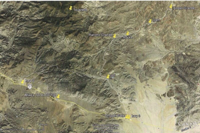
The jct for the Pole Line Rd is about 10 miles northeast of the Arroyo Grande pin.
[Edited on 6-7-2013 by TW]
|
|
|
TMW
Select Nomad
Posts: 10659
Registered: 9-1-2003
Location: Bakersfield, CA
Member Is Offline
|
|
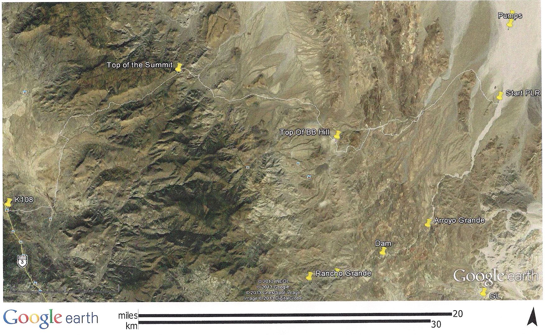
Here is another Google Earth view showing the relationship of the PLR, Summit and Arroyo Grande.
|
|
|
David K
Honored Nomad
Posts: 65590
Registered: 8-30-2002
Location: San Diego County
Member Is Offline
Mood: Have Baja Fever
|
|
Tom, what is the marker pin indicating in the lower right-corner?
|
|
|
TMW
Select Nomad
Posts: 10659
Registered: 9-1-2003
Location: Bakersfield, CA
Member Is Offline
|
|
That was the new section at the SF250 race this year that went around the mtn. GL means Go Left. Some pre-runners were missing the bear left line and
going right to a dead end.
|
|
|
| Pages:
1
2 |


