| Pages:
1
2 |
Bwana_John
Nomad

Posts: 300
Registered: 10-17-2007
Member Is Offline
|
|
| Quote: | Originally posted by mtgoat666
I think "tule" in the old California colony days was a word for low, swampy land or grass lands,... so maybe that can narrow down your review of
maps,...
tule makes me think of tule river or tule fog |
Or tularemia 
|
|
|
David K
Honored Nomad
Posts: 65590
Registered: 8-30-2002
Location: San Diego County
Member Is Offline
Mood: Have Baja Fever
|
|
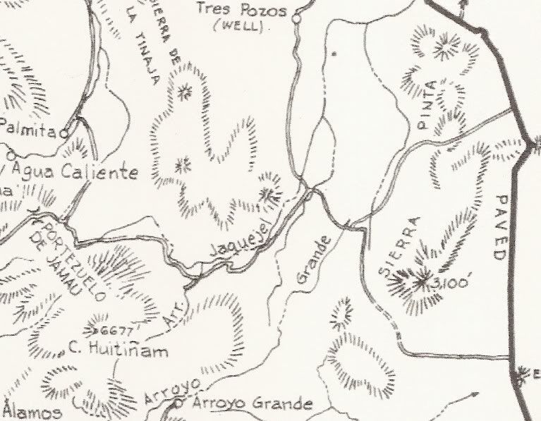
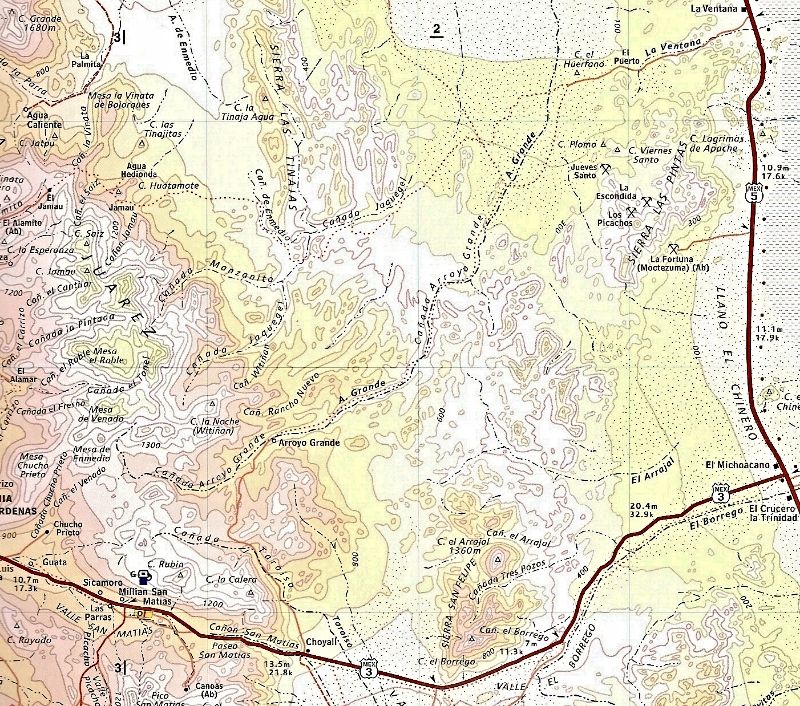
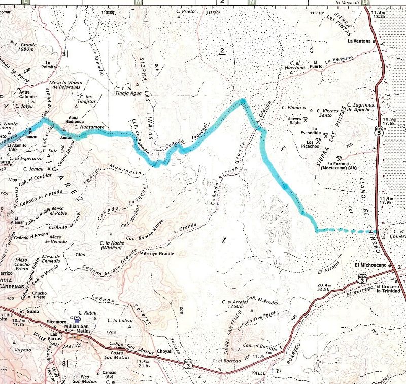
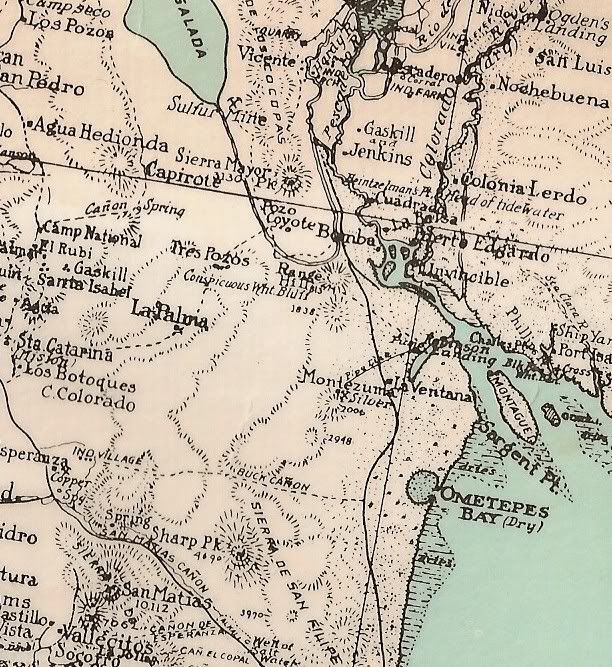
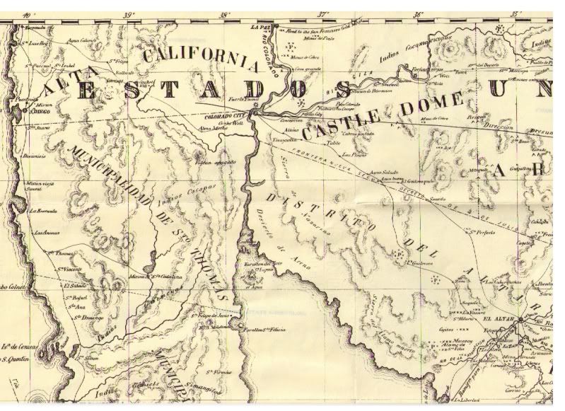
Arroyo El Tule/ Jaquegel (Jaquejel) region on maps
The name Tule for Jaquelgel appears on the 1919 Nelson expedition map showing the 1905 trip route, and is likely where Walter Henderson got the name
'Tule' when he explored the area in the 1930s. Here are what I have that show this area:
On the 1962 Gulick map, close up:
On the 2009 Topo map:
Pole Line Road highlighted:
Older maps:
1941:
1930:
1919 (Goldbaum):
1905/1919 (Nelson):
UP CLOSE:
"Arr. El Tule"
1865:

1864:
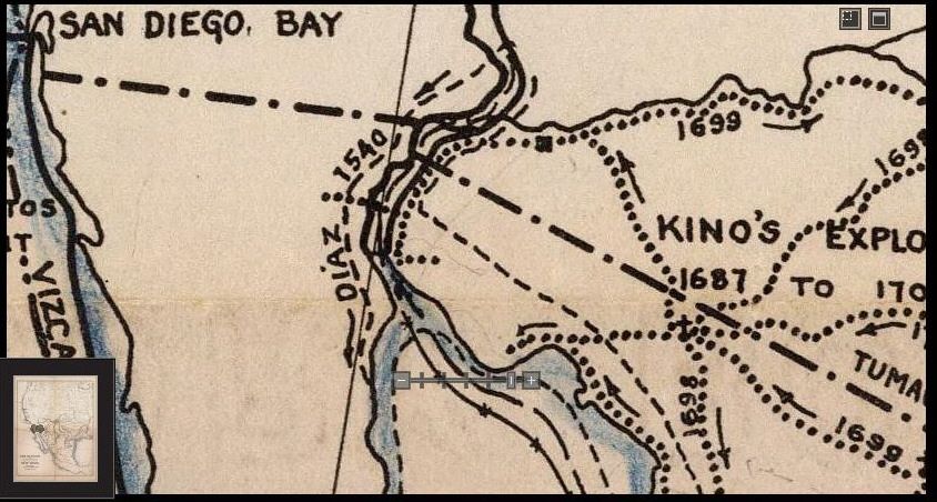
A 'modern' map showing the Diaz Expedition route down into Baja in 1540... Other historians think he was in Sonora when he died, and was buried there.
[Edited on 6-8-2013 by David K]
|
|
|
David K
Honored Nomad
Posts: 65590
Registered: 8-30-2002
Location: San Diego County
Member Is Offline
Mood: Have Baja Fever
|
|
Hope that all helps with the Arroyo Tule/Jaquegel question...
Here (in part) is the chapter from the last/ unpublished Choral Pepper book, where Tule Wash is mentioned... and the rest of the Lost Diaz Grave
story:
The explosive history of Diaz' grave first came to my attention through a letter from the late historian Walter Henderson while I was editor
of Desert magazine -- ?explosive? because it refutes several hundred years of fallaciously celebrating Padre Eusebio Kino as the first white man to
set foot on the west shore of the Colorado River. It was that chapter in my book that ignited Robinette's interest.
Baja California's true first European visitor to the northern sector was Melchior Diaz, a beloved Spanish army captain dispatched in 1540 by Coronado
to effect a land rendezvous with Fernando de Alarcon, whose fleet was carrying heavy supplies up the Gulf of California to assist in Coronado's
expedition in search of the fabled Seven Cities of Cibola.
It was during the depression of the early 1930s that Walter Henderson and his southern California companions cranked their Model A Ford roadster
through the rock arroyos of the unpaved road that led toward San Felipe, a Mexican fishing village about 125 miles south of the border at Mexicali. At
a spot a few miles beyond a window-shaped rock formation known as 'La Ventana', they unloaded their camping gear, filled their canteens from a water
tank in the rear of the car, and set out by foot.
On other of their frequent weekend safaris into Baja, if the Ford hadn't drunk too much of their water, they often camped overnight while searching
for old Spanish mines, Indian arrowheads, or whatever else adventure produced. Sometimes they found the powerful horns of a bighorn sheep arched over
its bleached and sand-pitted skull. At other times they heard the screeching wail of a wild cat or caught the fleeting shadow of a mule deer high up
in the Sierras. If a covey of quail flushed from a sparse clump of desert greasewood, they knew that water was nearby. Sometimes they found the
spring; most often they did not. Water is elusive in this rugged, raw land and rarely does it surface in a logical and accessible spot.
But on this cool day in April they were lucky. The Model A had behaved well and used less water than usual and they had managed to drive as far as the
foot of the Sierra Pintos with only three punched tires. Henderson had long fostered a yen to find a way into a canyon oasis he had heard about from
another man named Henderson (Randall, the founder of Desert magazine) who had described an oasis where native blue palms rose above huge granite
basins of water stored from mountain runoffs after storms.
As it turned out, they had hiked too far south. Baja California was only crudely mapped in those days and the Mexican woodcutters who supplied
ironwood for ovens to bake the tortillas of Mexicali and Tijuana had not yet been forced this far below the border, so there was no one to give
Henderson and his party directions.
Throughout the entire Arroyo Grande and Arroyo Tule watershed, they had found no sign of man -- just twisted cacti writhing across the sandy ground,
occasional stubby tarote trees, and lizards basking in the sun. On both sides of the wide arroyo up which they hiked, jumbled boulders stuck like
knobs to the mountainsides. In some areas the mountains were the deep, dark red of an ancient lava flow, in other sectors they were granite, bleached
as white as the sand in the wash.
When night fell, the hikers unrolled their sleeping bags, built an ironwood fire and fell asleep while watching the starry spectacle overhead. In
Baja's clear air, the stars appeared low enough to mingle with their campfire smoke.
At dawn, they brewed a pot of coffee, refried their beans from the night before, and tore hunks of sourdough from a loaf carried by one of the men in
his pack. There was no hurry. They had all day to explore as long as they kept moving back in the general direction of their car.
Late in the afternoon, after hiking across a range of hills, they came upon a curious pile of rocks set back a short distance from the edge of a steep
ravine. For miles around there had been no other signs of human life, neither modern nor ancient. The pile was nearly as tall as a man and twice as
long as it was high. The base was oval and the general shape of the structure resembled a haystack. The stones were rounded rather than sharp-edged,
and although the ground in the vicinity was not littered with them, Henderson and his companions figured that they had been gathered at great labor
from the general area.
They lifted a rock and turned it over. It was dark on the top, light colored underneath. The dark coating acquired by rocks in the desert is called
desert varnish. It is caused by a capillary action of the sun drawing moisture out of the rock. The dark deposit is left from minerals in the water.
In an arid region where rainfall is practically nil, desert varnish takes hundreds of years to form. The fact that these rocks were all coated by
desert varnish on the top indicated that they had remained in their positions for a very, very long time.
The men were tempted to investigate further, but it was the end of April, when the dangerous red rattlers of Baja California come out of hibernation,
so they contented themselves with speculation. The pile of rocks provided an inviting recess for these reptiles and the men were unarmed.
The rock pile stood close to the edge of a narrow ravine that twisted down from the hills over which they had descended. The site was not visible from
the surrounding country so it obviously was not intended as a landmark. That it was a grave, they felt certain, even though it was an unusually
elaborate structure for its isolated situation. Baja California natives have always conscientiously buried corpses found in remote countryside, but
usually the grave is simply outlined with a series of rocks rather than built up man-high like a monument. Whoever lay beneath this rock pile was
obviously revered by his companions who must have numbered more than a few in order to erect it.
Tilted against one end of the rock pile was an ancient piece of weathered ironwood nearly a yard long and as thick as a man's thigh. If a smaller
crosspiece had been lashed to it to form a cross, the addition had long ago eroded away. Ironwood, Olneya tesota, is a tall spreading tree found only
in washes of hot desert areas in the Southwest. Its wood is brittle, very hard and heavy, and it burns with a slow, hot flame. Mexican woodcutters
have all but depleted the desert of it in recent years, but during the 1930s when Henderson discovered the mysterious grave, it still was conceivable
that the heavy log could have been found close enough to drag to the graveside.
By this time the sun was falling low in the mountains behind them, so the men left the pile of stones and hurried on across the desert to reach their
car before nightfall. They never had occasion to return.
Two years later, however, the memory of the mysterious pile of rocks rose to taunt Henderson and continued to do so for the rest of his life.
The Narratives of Castaneda had been translated into English and a copy had fallen into his hands. When he came upon a passage that read " on a height
of land overlooking a narrow valley, under a pile of rocks, Melchior Diaz lies buried," he would have known immediately that he had found the lost
grave of this Spanish hero except for the fact that Pedro de Castaneda, who traveled as a scribe for Coronado, believed that Diaz was buried on the
opposite side of the Colorado River. However, Castaneda wrote his manuscript twenty years after it had happened and, since he was with Coronado rather
than with Diaz, his only authority was hearsay.
Melchior Diaz would have been completely ignored by history had it not been for the exploits of Fernando de Alarcon, who had been fitted out with two
vessels and sent up the Gulf of California by Viceroy Mendoza to support Coronado?s land expedition. A rendezvous had been arranged at which time the
land forces were to pick up supplies that Alarcon would bring by sea. As Coronado and his forces moved north, however, their guides led them further
and further toward what is now New Mexico, and away from the Gulf where they were to meet Alarcon. When Alarcon arrived at a lush valley near an
Indian village far east of the Gulf, he established a camp and dispatched Melchior Diaz westward with a forty-man patrol mounted on his best horses to
search for Alarcon?s ships and make a rendezvous on the Gulf.
Diaz, traveling west, arrived about 100 miles above the Gulf on the bank of the Colorado River. There he learned from an Indian who had helped drag
Alarcon's boats through the tidal bore that Alarcon had been there, but was now down river and had left a note on a marked tree near where the river
emptied into the Gulf.
Diaz then marched south for three days until he came to the marked tree. At the foot of it he dug up an earthenware jug with contained letters, a copy
of Alarcon's instructions, and a record of the nautical expedition's discoveries up to that point.
Knowing now that Alarcon was returning to Mexico, Diaz retraced his steps up the river to what is now Yuma, Arizona, where he forded the river. The
trail through Sonora by which he had come north took his army far inland from the sea. In the event that Alarcon still lingered in the area, Diaz
hoped that by following down the West Coast of the Gulf his men might be able to stay closer to the shore and thus sight the ships.
Marching southward from the present Yuma where they had crossed the Colorado, Diaz and his men came upon Laguna de los Volcanoes, about thirty miles
south of Mexicali. It is from this point that the narrative grows vague, except for the historical account of Diaz' fatal injury and subsequent
burial.
The injury occurred one day when a dog from an Indian camp chased the sheep that accompanied his troops. Angered Diaz threw his lance at the dog from
his running horse. Unable to halt the horse, he ran upon the lance that had upended in the sand in such a fashion that it shafted him through the
thigh, rupturing his bladder.
References vary as to how long he lived following the accident. Castenada reported that Diaz lived for several days only, carried on a litter by his
men under difficult conditions over rough terrain.
Castaneda's report may be flawed. Not only did he write it twenty years after the fact, but his report was based on hearsay evidence since he was with
Coronado in what is now New Mexico and not along the Colorado with Diaz. A more modern historian, Baltasar de Obregon, wrote that Diaz lived for a
month following the accident. Herbert Bolton, the distinguished California historian, wrote that after crossing the Colorado River on rafts, Diaz and
his troops made five or six day-long marches westward before turning back after Diaz' injury.
If Bolton's information relative to the days that they marched is correct, and if Castaneda is accurate relative to the number of days Diaz lived
after the accident, Diaz is buried on the West Coast of the Gulf. If he lived for a month, however, his grave very likely lies on the Sonora coast.
This has never been established, although historians have searched fruitlessly for the grave on the East Coast of the Gulf for several centuries.
So convinced was Henderson that he had found Diaz' grave that he proposed an investigation to the Mexican consul in Los Angeles. He was received
politely enough, but turned away with the deluge of problems his suggestion encountered. He was told that to conform to Mexican law of that time his
search party must consist of from two to four soldiers, an historian with official status, a guide to show them where they wanted to go, a cook to
feed them, and mules and saddles so the Mexican officials 'would not have to walk or carry packs on their backs like common peons.'
In addition, the party would have to include someone to put the mules to bed and saddle them, a muleteer, and a security guard to protect Diaz'
helmet, leather armor, blunderbuss, broadsword, coins, jewelry and whatever else of value accompanied the skeleton in the grave. All this was to be
paid for by Henderson. A further stipulation stated that if the area turned out to be too dangerous or rough for the retinue involved, regardless of
expense incurred, Henderson would be obliged to call off the whole thing and turn back.
This, during those years of the depression, was out of the question for Henderson, or just about anyone else. In later years the rigors of such a trip
for Henderson were too great. Faced with those complications, he ultimately went to his own grave never having solved the mystery of Diaz, but haunted
throughout life by the memory of that mysterious pile of rocks. So Diaz sleeps, a neglected hero while Mexicans and Americans alike pay homage to the
prevalent belief that Padre Eusebio Kino was the first white man to come ashore on the west side of the Colorado River.
Now that Baja has come into its own as a popular destination, the present government might be more amenable to investigating the gravesite if it can
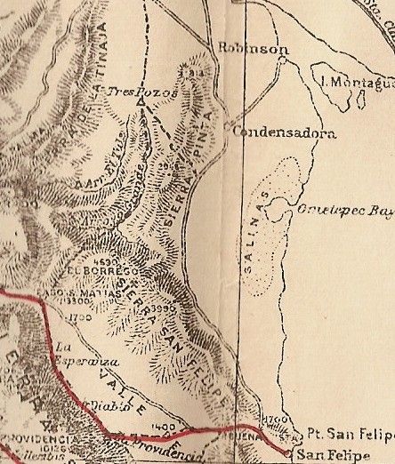
be found. According to Henderson's directions, a line drawn on the hydrographic chart of the Gulf of California from Sharp Peak (31 degrees 22 minutes
N. Lat., elevation 4,690, 115 degrees 10 minutes W. Long.) to an unnamed peak of 2,948 feet, NE from Sharp peak (about twelve miles away) will roughly
follow the divide of a range separating the watershed that flows to the sea. Somewhere near the center of that line, plunging down the westerly slope,
is a rather deep rock-strewn arroyo. On the north rim of this arroyo, and set back a short distance, is a small mesa-like protrudence, or knob of
land. There may be a number of arroyos running parallel. It is on one of these where the land falls away to the west that the rock pile overlooks the
arroyo. That was as close as Henderson was able to identify it on a map.
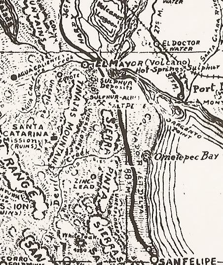
On one of my flights with Gardner in the 1960s, as we flew over land and water to Sierra Pinto, some thirty-two land-miles north of San Felipe, I
looked for a rugged ravine plunging down from the east side of Cerro del Borrego, a peak north of the present intersections of Highways 5 and 3, but
even the practiced eyes of pilot Francisco Munoz, who circled the area several times, were not sharp enough to etch a rock-covered grave out of the
colorless land. We did detect a dirt road about ten miles south of the La Ventana marker on modern maps that led into ruins of an old mine called La
Fortuna. That may have been where Henderson and his friends left their Model A Ford and initiated their hike.
So much for my treasure hunting competence!
Of interest, I have the original Walter Henderson letter and 'Rockpile' location notes. Choral Pepper changed a couple of details that were in the
letter, on accident or on purpose, we don't know.
|
|
|
PaulW
Ultra Nomad
Posts: 3113
Registered: 5-21-2013
Member Is Offline
|
|
| Quote: | Originally posted by TW
Here is another Google Earth view showing the relationship of the PLR, Summit and Arroyo Grande.
=========
Hi TW,
Been gone and am dealing with backlog of messages.
Anyway, Can you share the WP coords of your GE posts?
I will add a couple for you to add to your GE post.
The place I tell others where Arroyo Grande ends is 31.45179, 115.43670 El ~2464'. This is a place where its easy to turn around. I did make it to
31.45151, 115.44322 with dificulty due to cutting a bunch of tree branches and bushes. At that point is was obvious that more than a small saw was
needed as the trees were 3-6" in diameter. We walked for another hundred yards and just found more stuff to cut. Then headed back to SF.
Paul
[Edited on 6-10-2013 by PaulW] |
|
|
|
TMW
Select Nomad
Posts: 10659
Registered: 9-1-2003
Location: Bakersfield, CA
Member Is Offline
|
|
Here you go Paul.
K108 31.491400x115.777974 ~3478
Summit 31.627237x115.610338 ~4146
BB Hill 31.579715x115.438255 ~1833
Start PLR 31.625808x115.261799 ~795
Dam 31.475620x115.377519 ~2140
Rocks 31.452964x115.426170 ~2443
R. Grande 31.447703x115.454181 ~2592
Jct 31.374089x115.468476 ~3207
C. Gate 31.301795x115.427441 ~2169
Ranch east to get out about 1/4 mile. 31.300510x115416571 ~2049
|
|
|
| Pages:
1
2 |
|


