| Pages:
1
2 |
Ateo
Elite Nomad

Posts: 5965
Registered: 7-18-2011
Member Is Offline
|
|
Any favorite things to see in Gonzaga??
Hello Nomads,
Any favorite things to see in Gonzaga? Planning to do a trip soon...............
|
|
|
Ateo
Elite Nomad
Posts: 5965
Registered: 7-18-2011
Member Is Offline
|
|
And any favorite places to stay or basic motels? Probably not..............and I did search Nomad before posting this.
|
|
|
woody with a view
PITA Nomad
Posts: 15940
Registered: 11-8-2004
Location: Looking at the Coronado Islands
Member Is Offline
Mood: Everchangin'
|
|
alphonsinas is about the best place there unless you know someone with a house. lotsa beaches to explore.....
|
|
|
Pacifico
Super Nomad
Posts: 1299
Registered: 5-26-2008
Member Is Offline
|
|
Favorite things to see in Gonzaga?
I like to see a plate full of shrimp and a Pacifico in front of me at Alphonsina's! 
"Plan your life as if you are going to live forever. Live your life as if you are going to die tomorrow." - Carlos Fiesta
|
|
|
mcfez
Elite Nomad
Posts: 8678
Registered: 12-2-2009
Location: aka BN yankeeirishman
Member Is Offline
|
|
http://www.alfonsinasresort.com/
Has VERY simply rooms......not the Holiday Inn....but it's great. Restaurant is good chow....they will cook your day's fish for you too. Do indeed
call in for reservations.
There are other places nearby....many camps. Local store has everything that you could wish for. Plenty of fuel most of the time.
If you fish....this is the perfect Bay. Kayaking paradise ...especially if you go north of Punta Final. Great snorkeling there at PF too.
More info here:
http://forums.bajanomad.com/viewthread.php?tid=47044
This is my destination most of the time..... that I go to. The ride between San Felipe to GB is really cool. Very little development.
Old people are like the old cars, made of some tough stuff. May show a little rust, but good as gold on the inside.
|
|
|
Marc
Ultra Nomad
Posts: 2802
Registered: 5-15-2010
Location: San Francisco & Palm Springs
Member Is Offline
Mood: Waiting
|
|
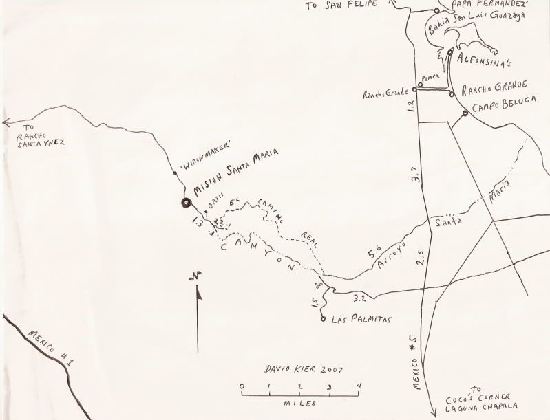
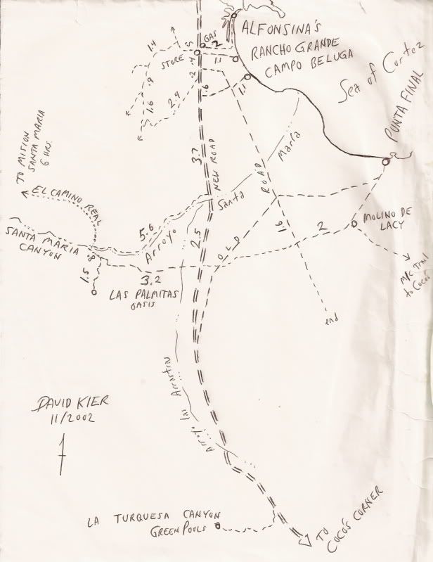
See DK's maps.
Las Palmitas
Hike up the same canyon there's a spring

[Edited on 12-21-2013 by Marc]
|
|
|
redhilltown
Super Nomad
Posts: 1130
Registered: 1-24-2009
Location: Long Beach, CA
Member Is Offline
|
|
You can always run out to Cocos or Calamajue as a day trip. If you have 4X4 there are great arroyos and canyons heading into the mountains as you
travel south from San Felipe...and great roads to the beach as well (though with the new road I am not sure as to access for some of the old faves.)
(possibly a map or two from DK is in order?). El Faro north of Papa Fernandez is a nice beach and the road north from there to Bufeo is fun with a
couple of access points to water (once again, I am hoping for 4x4.)
That said: Pacifico really nailed it!!! 
|
|
|
Casey67
Junior Nomad
Posts: 75
Registered: 4-4-2009
Location: Bahia Concepcion
Member Is Offline
Mood: Baja Hot
|
|
My favorite thing to see in Gonzaga is Gasoline. When I was there in January 2010 they had accidentally dropped the keys down into the main tank or
something like that and were closed for several days 
A rose by any other name is still just rice
|
|
|
basautter
Senior Nomad
Posts: 862
Registered: 7-1-2013
Member Is Offline
|
|
Gonzaga is one of my favorite places to go in Baja, and I always stay at Alfonsiona's. Great staff, great food, rooms are good. I spend most of my
time in/on the water when I am there(fishing/snorkeling). The bay is known for whale sharks, but I don't know about this late in the year. The
fishing is also great, but again. Send me an email for more info. One very unique feature is a soda spring geyser. It's about 1/4 mile west of
Rancho Grande (you can see it as a white spot on Google Earth). It only blows about once a month, so good luck!
|
|
|
Ateo
Elite Nomad
Posts: 5965
Registered: 7-18-2011
Member Is Offline
|
|
| Quote: | Originally posted by Casey67
My favorite thing to see in Gonzaga is Gasoline. When I was there in January 2010 they had accidentally dropped the keys down into the main tank or
something like that and were closed for several days |
Funny. I dropped an entire set of keys into a tank once in LA. Bye bye keys.
|
|
|
Ateo
Elite Nomad
Posts: 5965
Registered: 7-18-2011
Member Is Offline
|
|
Hello and Thanks All!
I will give this a read when I get home today.
I really appreciate the time you took to post links and photos. Gracias.
|
|
|
David K
Honored Nomad
Posts: 65589
Registered: 8-30-2002
Location: San Diego County
Member Is Offline
Mood: Have Baja Fever
|
|
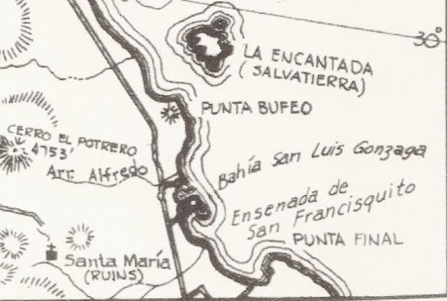
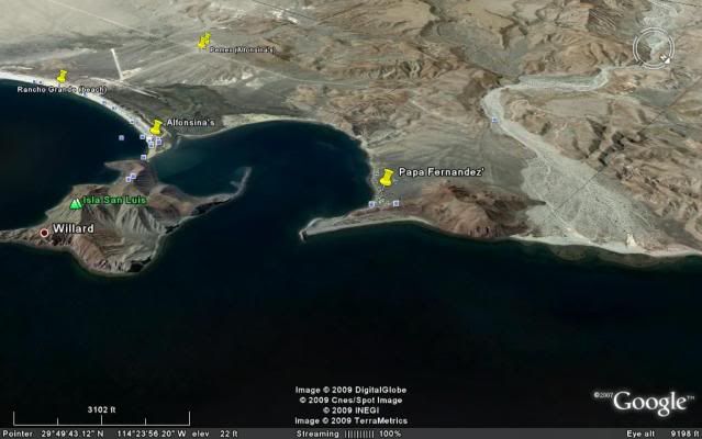
Jon, on my web page to Baja photos is a whole section on sites to see near Gonzaga Bay... Here's the list, and on the actual page they are clickable
links: http://vivabaja.com/tours/index.html
Bahia San Luis Gonzaga Area
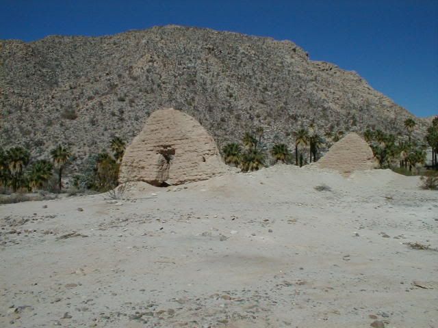
Mission-era warehouse ruins on the shore of the bay
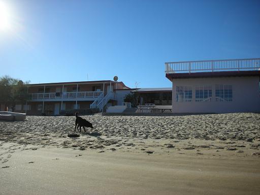
Alfonsina's Beach
Onyx Springs create a mineral glacier
Molino de Lacy ruins & grave
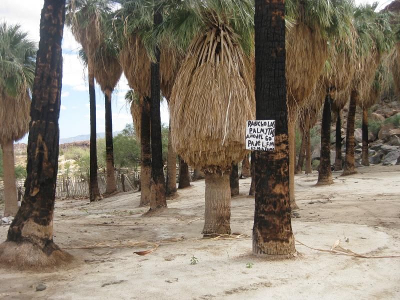
Las Palmitas oasis and Santa Maria Canyon
El Camino Real to Mision Santa Maria
Santa Maria Canyon from the air
La Turquesa Canyon
La Turquesa Grade
Calamajue mission site
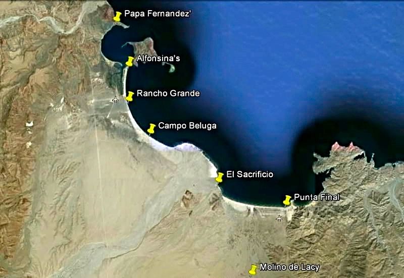
Campo Beluga (Gonzaga Bay)
Coco's Corner 11-06
Alfonsina's 11-06
more Coco's Corner
ALFONSINA'S MOTEL, on the beach:
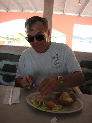
ALFONSINA'S GARLIC SHRIMP (being consumed with glee by The Squarecircle):


Private homes at Alfonsina's, south of motel/restaurant. The big hill is the island that separates Bahia San Luis Gonzaga from Ensenada de San
Francisquito:

View from the island trail:
Just up Santa Maria Canyon from the end of the road (past Las Palmitas turnoff):

Going north from the arroyo, before entering the canyon... EL CAMINO REAL:


GPS Directions (map datum NAD27 Mexico)
Take Hwy. 5 south 7.4 miles from Rancho Grande, turn west: 29°41.094'/ 114°24.566'
3.2 miles west of Hwy. 5, go straight where most traffic curves left for Las Palmitas: 29°41.278'/ 114°27.639'
0.8 miles from above, park at huge boulder: 29°41.68'/ 114°28.20'
Hike to north bank of Arroyo Santa Maria to: 29°41.733'/ 114°28.175' elev. 609' (ECR-1)
Go northwest and climb out of valley, note ocotillos.
Along left side of side valley: 29°42.374'/ 114°28.566' elev. 741' (ECR-2)
On first padre built switchback up: 29°42.669'/ 114°28.937' elev. 906' (ECR-3)
On a ridge, trail continues northwest: 29°42.671'/ 114°29.425' elev. 1308' (ECR-4)
On the Camino Real: 29°42.748'/ 114°29.482' elev. 1391' (ECR-5)
Crossing ridges and little mesas: 29°43.008'/ 114°29.967' elev. 1477' (ECR-6)
Drop along side of ridge, trail narrow: 29°43.074'/ 114°30.128' elev.1610' (ECR-7)
End of today's hike just beyond this last clear sign of the old trail: 29°43.141'/ 114°30.189' elev. 1702' (ECR-8)
Junction of ECR & bulldozed road: 29°43.126'/ 114°31.753' elev.1413'
(End of bulldozed road, on canyon ridge: 29°43.033'/ 114°31.556' elev. 1,615' )
Mision Santa Maria: 29°43.891'/ 114°32.794' elev.1628'
We did not make it to the mission that trip, as we left too late in the morning. Allow 6 hours one way, bring water! The other end of El Camino Real,
in the mission valley is shown here: http://vivabaja.com/msm/page8.html


There is no PH (for F sound) in Spanish!
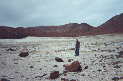
The onyx spring near Gonzaga... very interesting, (looks like a glacier) short hike.
Mission warehouse on shore of Gonzaga Bay (~1769+)

So much to see...
|
|
|
Bob H
Elite Nomad
Posts: 5867
Registered: 8-19-2003
Location: San Diego
Member Is Offline
|
|
Great maps David... as usual!! Thanks.
The SAME boiling water that softens the potato hardens the egg. It's about what you are made of NOT the circumstance.
|
|
|
Casey67
Junior Nomad
Posts: 75
Registered: 4-4-2009
Location: Bahia Concepcion
Member Is Offline
Mood: Baja Hot
|
|
Enjoy Gonzaga 'as is' while you can. In 2029 once the road is fully paved to HWY1 it will become the defacto route in and out of Baja for every gringo
I've talked to, which means a lot of changes. I'm all for the paving though, no more San Quintin to TJ crawl through the sprawl.
A rose by any other name is still just rice
|
|
|
David K
Honored Nomad
Posts: 65589
Registered: 8-30-2002
Location: San Diego County
Member Is Offline
Mood: Have Baja Fever
|
|
2029 huh? Are we taking bets on the last 38 miles to Chapala?
|
|
|
treuboff
Nomad
Posts: 127
Registered: 8-27-2013
Location: prescott az
Member Is Offline
|
|
El Sacraficio is on the web and has a kitchen and rooms. Snorkeling or Scuba at Punta Final. Water is clear, take your own gear. Most of the time just
being there is good enough.
|
|
|
Marc
Ultra Nomad
Posts: 2802
Registered: 5-15-2010
Location: San Francisco & Palm Springs
Member Is Offline
Mood: Waiting
|
|
| Quote: | Originally posted by treuboff
El Sacraficio is on the web and has a kitchen and rooms. Snorkeling or Scuba at Punta Final. Water is clear, take your own gear. Most of the time just
being there is good enough. |
OK for rooms-not so good for camping
|
|
|
Ateo
Elite Nomad
Posts: 5965
Registered: 7-18-2011
Member Is Offline
|
|
Wow. I can tell you all love this place by the time you have spent posting photos and giving advice. Thanks for taking the time. I'm taking notes.
I think my wife is gonna dig this area. We're either gonna hit it up on the drive south, or the drive back north from, or heading to the Pacific
Coast for some waves!!
|
|
|
David K
Honored Nomad
Posts: 65589
Registered: 8-30-2002
Location: San Diego County
Member Is Offline
Mood: Have Baja Fever
|
|
| Quote: | Originally posted by Ateo
Wow. I can tell you all love this place by the time you have spent posting photos and giving advice. Thanks for taking the time. I'm taking notes.
I think my wife is gonna dig this area. We're either gonna hit it up on the drive south, or the drive back north from, or heading to the Pacific
Coast for some waves!! |
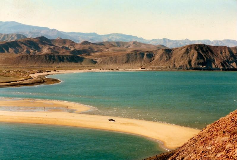
Jon, the beach is perfect, especially at Alfonsina's to Beluga and again at Punta Final (nice sand). There is a beach outside the bay, and over the
hill from Papa Fernandez' restaurant (on the outer side of Willard Point for camping.
So, if the weather isn't good for beach activity all day, then Gonzaga has all these other places to see... and more. As you saw in the photo from
Marc (location on my hand drawn map), Las Palmitas is an oasis... I mean Baja is like magic the places water comes out of the ground, and thanks to
birds, palm trees grow there! The El Camino Real comes the closest to sea level by Gonzaga (at Arroyo Santa María) since leaving Loreto! Gold ore was
milled at Molino de Lacy (originally called Molino de San Francisquito before William Lacy died). The processed gold was shipped from the beach by
today's Punta Final resort (then called Puerto de San Francisquito) on Ensenada de San Francisquito (the bigger half of 'Gonzaga Bay').
[Edited on 12-21-2013 by David K]
|
|
|
David K
Honored Nomad
Posts: 65589
Registered: 8-30-2002
Location: San Diego County
Member Is Offline
Mood: Have Baja Fever
|
|
Just great places... from BajaTaco in 2002
I remembered Chris talking about his run up Arroyo Alfredo... this is the wash the new Hwy. 5 bridge crosses right before Papa Fernandez' driveway.
The Franciscan Padre Serra cargo trail from Gonzaga to the Camino Real goes up this way (how supplies were brought to San Fernando de Velicatá
mission). It saved a bit of travel by not detouring south to Mission Santa María from Gonzaga Bay.
Baja Bucko traveled the cargo trail by mule in 2001 and recorded a Geo-Cache at an oasis up that way: http://www.geocaching.com/geocache/GC8C7_no-wheels-need-appl...
You can see the 1769 built mission road on Google Earth between the area of the oasis and where it joins to Camino Real (overlaid by the 4WD road to
Mission Santa María from Santa Ynez.
[Edited on 1-17-2014 by David K]
|
|
|
| Pages:
1
2 |