gorv
Newbie
Posts: 10
Registered: 10-3-2013
Member Is Offline
|
|
Crossing northbound at Algodones
We will be heading north from La Paz in a few weeks via Gonzaga/San Felipe and are considering crossing at Algodones rather than the Mexicali East
crossing which we have taken the past 2 years. Any suggestions on the best route to take from Mex 5 would be appreciated. We aren't towing, just a
pickup. Any tricky turns to watch out for?..thanks...
|
|
|
Marc
Ultra Nomad

Posts: 2802
Registered: 5-15-2010
Location: San Francisco & Palm Springs
Member Is Offline
Mood: Waiting
|
|
Did it last year. Not a busy crossing & easy to find. Maybe 20 minute line. We were sent to secondary for being two very suspicious looking 70+
fishermen.
|
|
|
Pescador
Ultra Nomad
Posts: 3587
Registered: 10-17-2002
Location: Baja California Sur
Member Is Offline
|
|
I stay on Hwy 2 and take the last exit before crossing the river at San Luis, and follow along the river into Algodones. You can also come in at
Benito Juarez and through Cuidad Morelos on BCN6 but you have to go north at Morelos and then take hwy 8 the rest of the way into Algodones.
|
|
|
Riom
Nomad
Posts: 492
Registered: 12-17-2004
Member Is Offline
|
|
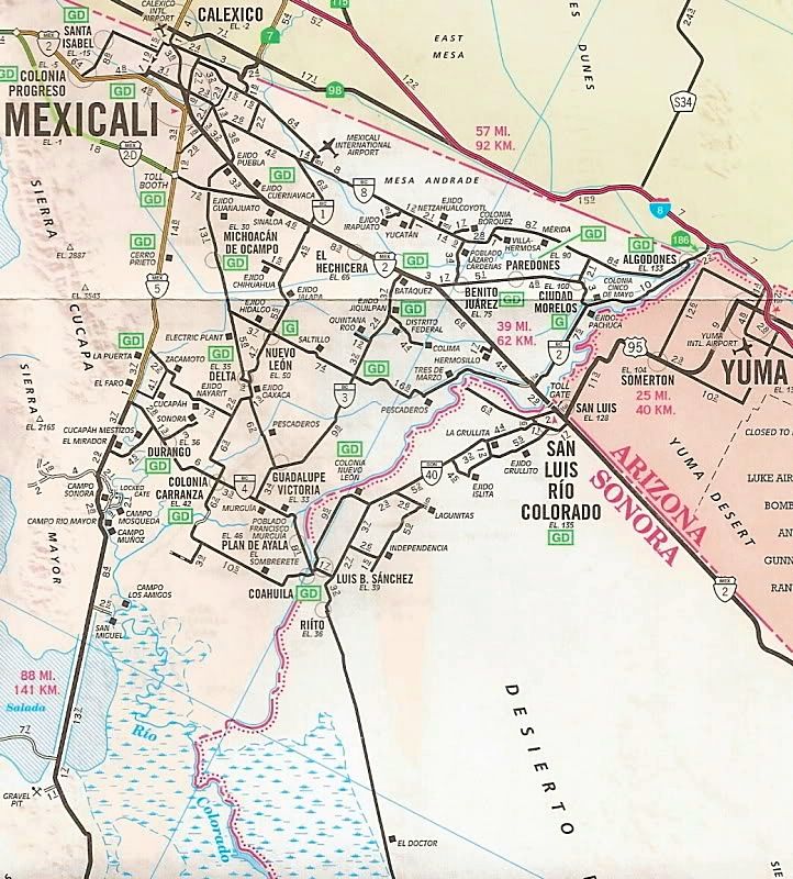
I agree with Pescador, stay on Mexico 2 almost until San Luis Rio Colorado, then head north on BC 2 following the river. See the map below.
In detail:
Head north from San Felipe on Mex 5. When you go under the Mex 2 bypass (before Mexicali), do a U-turn a few hundred yards up the road, and go back
to where you can get on it, following the signs to San Luis Rio Colorado (SLRC). Pay toll on entry (20 pesos).
Continue on Mexico 2 towards SLRC. After a while there's a sign for Algondones. That's the disconnected zig-zag line on the map. That's slightly
shorter but takes you through a lot of small towns and a few turns, OK but hard work.
It's easier to stay on Mexico 2 until the next Algodones sign (this is the continuous line on the map, by the border), which is right on a long
flyover shortly before you get to SLRC (if you get to the toll bridge, you've gone too far). Coming down off the highway by following that Algodones
sign, take a sharp left under the highway and go straight across the roundabout (it's not marked).
You are now on a narrower road, few fields then there is a canal on the left. Follow this road (BC 2) straight ahead all the way. Just the edge of
one village with topes, otherwise an easy run.
As you approach Algodones, with sand dunes on the left, there's a big dam on the right (and big topes). After the dam, the road bears left. At the
first stop sign, with a walled sports field on the right, turn right. You're now on the road that leads to the border, just follow it all the way
along and eventually you'll be at the end of the line (in other words, the stopped traffic in front of you is the end of the queue, there's just one
lane).
I've crossed that border with 2 cars in front of me, and another time with an hour and three quarter wait, but it's generally 15-20 minutes on a good
day, not often over an hour.
[Edited on 2014-3-7 by Riom]

|
|
|
David K
Honored Nomad
Posts: 65589
Registered: 8-30-2002
Location: San Diego County
Member Is Offline
Mood: Have Baja Fever
|
|
Thanks Riom... I was wondering which farm road was less farm and more road!
Here's the AAA map of the area:
|
|
|
RogerMears
Junior Nomad
Posts: 30
Registered: 3-7-2014
Location: Bahia de Los Angeles
Member Is Offline
|
|
Cross at Algodones
We are planning a trip to the border next week and want to cross at Algodones. We will be towing a 28' empty toy hauler. We will be traveling from
Bahia de Los Angeles taking the Lake Chapala turn off, heading for Coco's corner, Gonzaga Bay, thru San Felipe then we were going to take Hwy. 4 to
Hwy. 3 thru Guadalupe Victoria to Hwy. 2, to Los Algodones. Has anyone traveled this route?? We know about the 38 miles of dirt road and will let
air out of tires and travel very slow. We did read that RVs cross back and forth at Los Algodones so we are assuming our toy hauler will cross just
fine as well. Can anyone enlighten us on our travel plans and if anyone has taken the route we are taking?
Also, what is up with a protest on Hwy 5 blocking lanes both ways. Hopefully that is resolved!!!
Thanks for any suggestions from anyone familiar with our planned route!!
|
|
|
Pappy Jon
Nomad
Posts: 494
Registered: 8-27-2003
Location: Wrong side of the Continental divide.
Member Is Offline
Mood: Temp rising.
|
|
Fabulous! I take the ziz-zag road. I will try this next time. I might even try it in reverse going south.
"The association of flowers and warm-blooded love is more than a romantic convention; it is based upon one of the great advances in the evolution
of life." Ed Abbey
|
|
|
Pappy Jon
Nomad
Posts: 494
Registered: 8-27-2003
Location: Wrong side of the Continental divide.
Member Is Offline
Mood: Temp rising.
|
|
| Quote: | Originally posted by RogerMears
We are planning a trip to the border next week and want to cross at Algodones. We will be towing a 28' empty toy hauler. We will be traveling from
Bahia de Los Angeles taking the Lake Chapala turn off, heading for Coco's corner, Gonzaga Bay, thru San Felipe then we were going to take Hwy. 4 to
Hwy. 3 thru Guadalupe Victoria to Hwy. 2, to Los Algodones. Has anyone traveled this route?? |
Yes, I used to go that way. It took too long, especially when compared to the MX2 toll road to MX5. Those little villages really eat up time.
"The association of flowers and warm-blooded love is more than a romantic convention; it is based upon one of the great advances in the evolution
of life." Ed Abbey
|
|
|
gorv
Newbie
Posts: 10
Registered: 10-3-2013
Member Is Offline
|
|
Thanks for all the info
.the directions and the maps. Much appreciated and we may give it a go.
|
|
|
Riom
Nomad
Posts: 492
Registered: 12-17-2004
Member Is Offline
|
|
| Quote: | Originally posted by RogerMears
We are planning a trip to the border next week and want to cross at Algodones. We will be towing a 28' empty toy hauler. ... take Hwy. 4 to Hwy. 3
thru Guadalupe Victoria to Hwy. 2, to Los Algodones. ...
Also, what is up with a protest on Hwy 5 blocking lanes both ways. Hopefully that is resolved!!!
Thanks for any suggestions from anyone familiar with our planned route!! |
I did the 4, 3, 2 route once a long time ago. Very slow, too many towns. Since the upgrading of Mex 2 to 4 lanes all the way from SLRC to Mexicali,
and the opening of the Mexicali toll bypass, it's much easier to stick to those. (the AAA map has one error: the 7.2 mile section of the 2-D bypass
east of 5 should be in green as it's also a toll, 20 pesos).
I haven't seen many trailers (or even A-classes) crossing northbound at Algodones. The last corner in particular is quite tight (see satellite
image). Nothing to actually stop you as far as I can tell (I don't tow) but Mexicali East would be easier.
The road block protest in San Felipe was just for a few hours, nothing since.

|
|
|