| Pages:
1
2
3 |
redhilltown
Super Nomad

Posts: 1130
Registered: 1-24-2009
Location: Long Beach, CA
Member Is Offline
|
|
| Quote: | Originally posted by 250xcfw
| Quote: | Originally posted by redhilltown
La Gringa? North of town just about as far as you can go. Great views, sand, water...nothing else except a nice guy who will come around once a day
and collect the rent. |
How much rent? How's the fishing in La Gringa?
John |
I "think" for our regular vehicles it was $5.00 a day...the usual going rate in Baja...for your rig I am not sure. Fishing is just your resident
locals of bay bass, triggers, corvina and a few others. For the most part the shore fishing in L.A. Bay is not too exciting. Find Igor at
Guillermo's or stop by Dagget's if you want a day on the water...depending on how important fishing is to you. They will find you something. If shore
fishing is key then head south to Bahia de Las Animas or San Rafael. Rough roads though and I'm not sure if you are towing a Jeep or the like...a bit
far for quads.
|
|
|
David K
Honored Nomad
Posts: 65589
Registered: 8-30-2002
Location: San Diego County
Member Is Offline
Mood: Have Baja Fever
|
|
| Quote: | Originally posted by 250xcfw
| Quote: | Originally posted by David K
Well, a paved road goes about halfway to La Gringa from town. Riding a quad on it is probably not an issue with anyone?
An all dirt to town option is to camp at the south end of the bay... huge all sand beach... about 6 miles south of town, just past Muñoz' property,
where the bay bottoms out. |
What is the place called in La Gringa ? Are there signs? GPS location?
John |

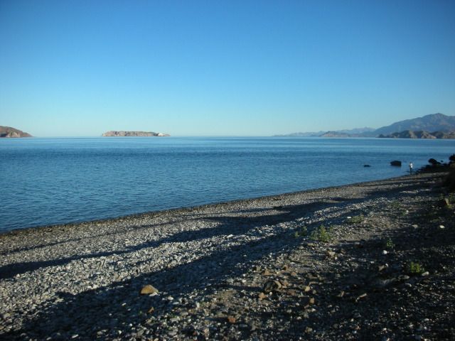
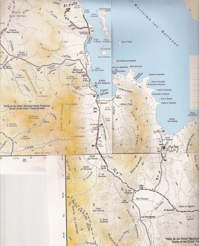
La Gringa up close
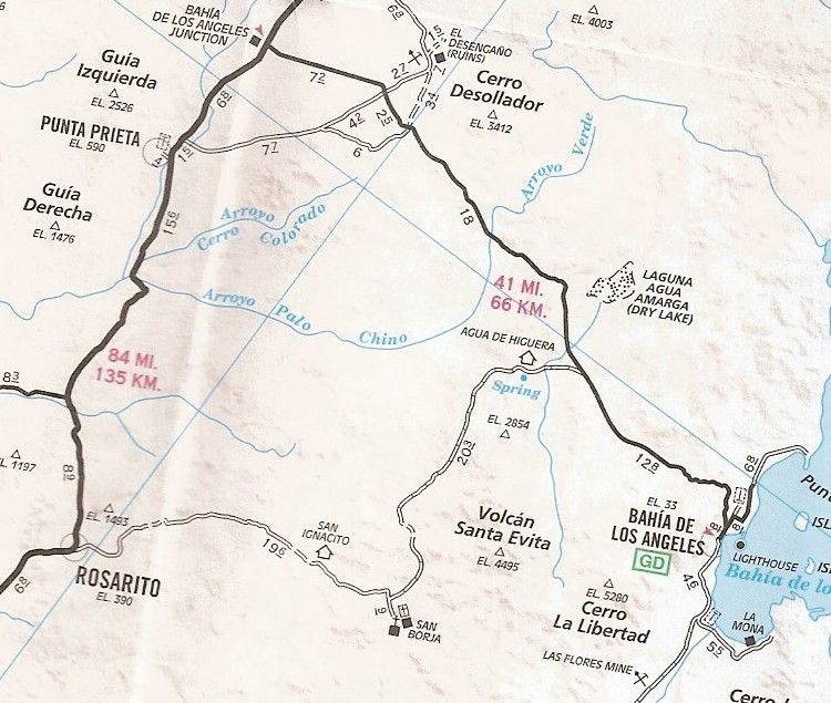
See the road going north from the town of L.A. Bay, mileages 0.8 and then 6.8, paved half way? That's the La Gringa road... The Punta La Gringa (with
this map cut off after Pun...) is it... the north end of L.A. Bay.
Some photos taken there...
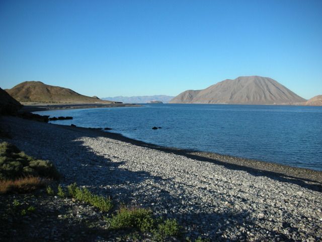
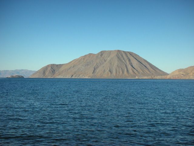
Smith Island (a volcano) is just off shore.
L.A. BAY as seen where the highway comes out of the mountain...

There's La Gringa and Smith Island, beyond...
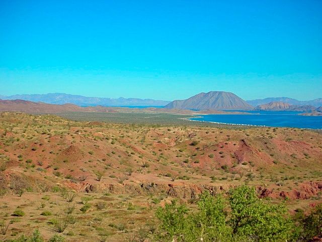
A sand beach is just before La Gringa, as well.
|
|
|
250xcfw
Newbie
Posts: 18
Registered: 2-16-2014
Location: Central Oregon
Member Is Offline
|
|
Looks good to me, I'm thinking of staying at Daggetts and using it for a base for a day or two. Then using the quads to scout the roads before going
to far off the beaten path. La Gringa looks like what I'm after.
I've been using https://maps.google.com/maps/ms?msa=0&msid=2049990104019... for rv parks along the way. It seems to have quit a few spots to camp but little
detail on most.
Once again thanks for all the info and once again everyone has given more than I ever expected.
My next stop will be Santa Rosalia area, Mulege area, and then on to Loreto.
Thanks,
John
|
|
|
250xcfw
Newbie
Posts: 18
Registered: 2-16-2014
Location: Central Oregon
Member Is Offline
|
|
This is my setup I'm big and heavy 5th wheel toy hauler with quads and kayaks on board for exploring both land and sea. If you see me stop by and have
a beer.
[Edited on 3-8-2014 by 250xcfw]
[Edited on 3-8-2014 by 250xcfw]
|
|
|
David K
Honored Nomad
Posts: 65589
Registered: 8-30-2002
Location: San Diego County
Member Is Offline
Mood: Have Baja Fever
|
|
Hi John,
I think the best data on motels and campgrounds at Bahia de los Angeles is at Mia's web site: http://bahiadelosangeles.info
Here is the page over there: http://bahiadelosangeles.info/rv-trailer-parks.htm
Daggett's is along the La Gringa road, right by Raquel & Larry's Motel.
There is a copper mine about 7 miles north and west from La Gringa that makes an interesting side trip... It is the El Toro copper mine, and not on
maps (most maps).
The copper ore (green rock) was shipped out from La Gringa... and some ore may still be seen along the hill there. Tossed into a campfire, the copper
adds beautiful colors to the flames once it heats up. Paulina named them 'Magic Rocks'... 
|
|
|
David K
Honored Nomad
Posts: 65589
Registered: 8-30-2002
Location: San Diego County
Member Is Offline
Mood: Have Baja Fever
|
|
| Quote: | Originally posted by 250xcfw
This is my setup I'm big and heavy. I've have quads and kayaks on board for exploring both land and sea. If you see me stop by and have a beer.
[Edited on 3-8-2014 by 250xcfw] |
I am going to guess that you tried to upload a photo directly from your folder onto Nomad (using the attachment feature)?
Sadly, the photo must be shrunk to under 50 kb to show here... BUT, a better way, that doesn't reduce the photo quality or use bandwidth on Nomad, is
to use a photo hosting site, such as Photobucket.com. Just set the UPLOAD size to 800 pixels or less to not distort the page. Full instructions on how
to use Photobucket for Nomad are at the top of the Nomad Photo forum, here: http://forums.bajanomad.com/viewthread.php?tid=65085
|
|
|
250xcfw
Newbie
Posts: 18
Registered: 2-16-2014
Location: Central Oregon
Member Is Offline
|
|
Yes, I was trying to use the upload function.
What maps are you using or what are the best maps to use?
John
|
|
|
redhilltown
Super Nomad
Posts: 1130
Registered: 1-24-2009
Location: Long Beach, CA
Member Is Offline
|
|
Uh oh!!! A David K map question!!!!!!! 
You have come to the right place John!
Final thought on La Gringa...good place to hear the whales sing at night if it is quiet/no wind...quite magical if you've never heard it.
|
|
|
David K
Honored Nomad
Posts: 65589
Registered: 8-30-2002
Location: San Diego County
Member Is Offline
Mood: Have Baja Fever
|
|
The Baja Almanac (topo road/ trail map book) would be #1, and the AAA Baja map is next as far as usefulness. The Nat Geo maps are nice and big, but
really don't help with planning where to go.
Google Earth or Bing Birdseye satellite images are great to see what's there and where there are track to explore... Most or only a year to 6 old, so
you can see all the roads and tracks in Baja... You just need to know where to look!
In my web site, are lots of resources and pages to look at to help plan a Baja adventure... There is so much I have put in them, I am happy to help. I
just need to know where you will be based, what you will be driving/ riding and what is interesting to you. I did make a index that you can click on
to see some points of interest around various Baja destinations.... look here: http://vivabaja.com/tours
Here's the sites listed for L.A. Bay on that page:
Bahia de los Angeles Area
Tinaja de Yubay
Punta Candeleros & Remedios (Bahia Guadalupe)
El Toro Copper Mine
Camp Gecko cabin, turtle research station, & La Gringa
Bahia de los Angeles highway, Pemex, etc. '05
Bahia de los Angeles Museum
Mision San Borja
Mision San Borja (inside)
Old San Gregorio
Santa Ana, San Ignacito
Montevideo Petroglyphs
Las Tinajitas Petroglyphs
Camp Gecko '03
Las Flores
Los Paredones, La Bocana, Bahia San Rafeal
Las Flores Railroad and Tramway
Rock Palm Hill (near Yubay)
Bahia las Animas
Punta La Gringa
Mysterious Ruins/ Lost Mission Site?
[Edited on 3-8-2014 by David K]
|
|
|
250xcfw
Newbie
Posts: 18
Registered: 2-16-2014
Location: Central Oregon
Member Is Offline
|
|
I should be entering Mex in the AM and headed south. Wish me luck.
I will try and ask question as i go but I not sure on reception.
Thanks for the help.
John
|
|
|
redhilltown
Super Nomad
Posts: 1130
Registered: 1-24-2009
Location: Long Beach, CA
Member Is Offline
|
|
Have a safe fun trip and please report back!
|
|
|
wilderone
Ultra Nomad
Posts: 3915
Registered: 2-9-2004
Member Is Offline
|
|
"What is the place called in La Gringa?"
It's at the end of the road north of town. Some brutle washboard en route. You'll see the military camp and then it's just past. There's a fenced
area with camp sites, or you can find dispersed camping. Some of the larger places for larger vehicles are right on the sand - make sure you won't get
stuck. And you'll have to make some turns, in, out and around.
|
|
|
absinvestor
Senior Nomad
Posts: 725
Registered: 11-28-2009
Member Is Offline
|
|
Lots of good info. I would just reiterate two things. After San Quintin the road narrows to 19ft. Many times the 18 wheelers take up more than their
half. No shoulders so lots of mirrors lost and a few roll overs so be careful. I did one Santa Semana in Baja and would not do it again. During Santa
Semana finding beach parking for anything bigger than a tricycle will be impossible. Santa Semana is from April 13th to April 20th. The crowds will
start a couple days earlier. You'll have lots of fun- enjoy!!

|
|
|
redhilltown
Super Nomad
Posts: 1130
Registered: 1-24-2009
Location: Long Beach, CA
Member Is Offline
|
|
| Quote: | Originally posted by wilderone
"What is the place called in La Gringa?"
It's at the end of the road north of town. Some brutle washboard en route. You'll see the military camp and then it's just past. There's a fenced
area with camp sites, or you can find dispersed camping. Some of the larger places for larger vehicles are right on the sand - make sure you won't get
stuck. And you'll have to make some turns, in, out and around. |
Yikes! I don't remember brutal washboard, fences, or a military camp!! But I was there for fishing and I guess my brain (what is left of it that is)
was focused somewhere else...
|
|
|
250xcfw
Newbie
Posts: 18
Registered: 2-16-2014
Location: Central Oregon
Member Is Offline
|
|
Made it to Loreto everything going good. Any good places to camp on the beach north of Loreto.
|
|
|
shari
Select Nomad
Posts: 13052
Registered: 3-10-2006
Location: bahia asuncion, baja sur
Member Is Offline
Mood: there is no reality except the one contained within us "Herman Hesse"
|
|
| Quote: | Originally posted by RnR
Mexican "semana santa" is a Mexican tradition to head to the beaches for the entire week. ALL beaches (everywhere in the country) will be beyond
PACKED! |
Not true amigo...the beaches on the Gulf side will be packed but the Pacific side beaches are mostly empty as all the locals from our side go over to
the Gulf for nice hot weather. It's a good time to visit the Pacific side in places like Bahia Asuncion, La Bocana, Abreojos where the villages are
like ghost towns on the long weekend.
|
|
|
David K
Honored Nomad
Posts: 65589
Registered: 8-30-2002
Location: San Diego County
Member Is Offline
Mood: Have Baja Fever
|
|
| Quote: | Originally posted by 250xcfw
Made it to Loreto everything going good. Any good places to camp on the beach north of Loreto. |
Hope you get a reply for north, but south of Loreto, past Puerto Escondido, is PLAYA LIGUI, just before the highway climbs the mountain. Public sand
beach with palapas.
|
|
|
DavidE
Ultra Nomad
Posts: 3814
Registered: 12-1-2003
Location: Baja California México
Member Is Offline
Mood: 'At home we demand facts and get them. In Mexico one subsists on rumor and never demands anything.' Charles Flandrau,
|
|
Semana Santa on the Pacific side! Shorts and Tee shirt time
If you bring a 12 foot parabolic mirror...
A Lot To See And A Lot To Do
|
|
|
250xcfw
Newbie
Posts: 18
Registered: 2-16-2014
Location: Central Oregon
Member Is Offline
|
|
So how is the hwy south coming out of San Felipe? One of the guys staying next to use is planning on going home that way? Any thoughts?
John
|
|
|
David K
Honored Nomad
Posts: 65589
Registered: 8-30-2002
Location: San Diego County
Member Is Offline
Mood: Have Baja Fever
|
|
The pavement expansion south of San Felipe has got to be one of the most common topics here on Nomad, not sure how you miss seeing them!? 
I don't mind repeating data for anyone who can't find it...
San Felipe to Gonzaga Bay is PAVED (100 miles)... pavement ends about 2 miles south of the Gonzaga Pemex (Alfonsina's entrance)/ Rancho Grande store,
per a Nomad.
From the end of pavement to Hwy. 1 (Laguna Chapala) is about 34 miles and is a 2WD graded dirt road, but ROUGH surface from rocks, washboard, lack of
maintenance. Low cars, trailers, motorhomes would do better to go around via San Quintin on all paved roads.
|
|
|
| Pages:
1
2
3 |


