ligui
Senior Nomad

Posts: 896
Registered: 2-9-2008
Location: Fraser co.
Member Is Offline
Mood: love Baja !
|
|
Loreto Road construction
How about an update on the 4 lane road heading out of town .
Are they really planning on heading all the way to Ligui with 4 lanes ?
Pics. ?
Thanks ! i'll headed down in about a month , looking forward to the Heat . 
|
|
|
Bajahowodd
Elite Nomad
Posts: 9274
Registered: 12-15-2008
Location: Disneyland Adjacent and anywhere in Baja
Member Is Offline
|
|
Kinda funny since that from the time they opened the Villas Group property down South, I have wondered just why the stretch of Mex 1 from Loreto down
to the point where it heads up the hill toward Insurgentes was probably the worst in all Southern Baja. Guess the Villa folks had some juice.
|
|
|
Udo
Elite Nomad
Posts: 6364
Registered: 4-26-2008
Location: Black Hills, SD/Ensenada/San Felipe
Member Is Offline
Mood: TEQUILA!
|
|
IMHO:
The stretch about 20 miles below San Ignacio (I think it is called Ejido Alfredo Bonfil) and reaching Santa Rosalia, is the worst stretch in all of
Baja. Very narrow mountainous road, huge cliffs at every turn, and 18 wheelers who constantly cross the center lane. It seems like 25 miles of pure
stress when driving that stretch of road.
Udo
Youth is wasted on the young!
|
|
|
David K
Honored Nomad
Posts: 65589
Registered: 8-30-2002
Location: San Diego County
Member Is Online
Mood: Have Baja Fever
|
|
| Quote: | Originally posted by Udo
IMHO:
The stretch about 20 miles below San Ignacio (I think it is called Ejido Alfredo Bonfil) and reaching Santa Rosalia, is the worst stretch in all of
Baja. Very narrow mountainous road, huge cliffs at every turn, and 18 wheelers who constantly cross the center lane. It seems like 25 miles of pure
stress when driving that stretch of road. |
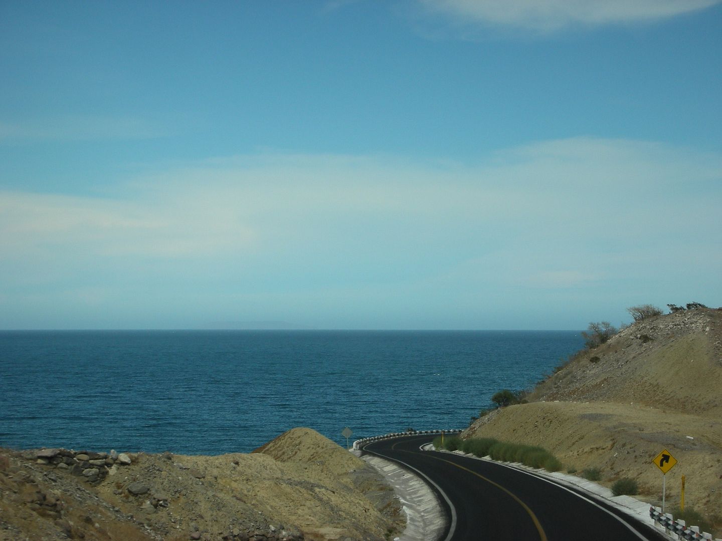
The Grade to Hell (Cuesta del Infierno) was widened in July 2012... it was crazy narrow and steep before then! However, you will admit Udo, that
driving southbound... after hundreds of desert miles, seeing the gulf for the first time on Hwy. 1 is really something!
|
|
|
Paula
Super Nomad
Posts: 2219
Registered: 1-5-2006
Location: Loreto
Member Is Offline
|
|
Ligui, I don't know how far the 4 lane section will go, but the stretch to the airport and a ways past is in good shape. Yellow lines mark the lanes,
and there is an American style left turn lane into the airport. There are several construction zones south of the finished part, the worst being at
Mirador Frida. They seem to let people pass through every hour, so if you learn to time it right it isn't too bad (or too good), but you could wait
there for nearly an hour either direction. I hear there are many construction zones heading south all the way to Insurgentes, but we haven't gone
past Ensenada Blanca for several months.
|
|
|
RnR
Senior Nomad
Posts: 841
Registered: 5-1-2010
Member Is Offline
|
|
| Quote: | Originally posted by ligui
How about an update on the 4 lane road heading out of town .
Are they really planning on heading all the way to Ligui with 4 lanes ?
Pics. ?
Thanks ! i'll headed down in about a month , looking forward to the Heat . |
Not sure about the extent of the 4-lane.
There is MAJOR work going on at the Mirador area. There are currently three large excavators WAY above the current highway bringing down a new cut
slope. At least a 100 ft up! Looking beyond and above them, the top of the new slope was probably another 100 ft above the level that they were
working on.
No other signs of new construction except for this major excavation at the Mirador. But, there must be bigger plans than a new Mirador in the works.
This cut slope work alone will probably go on for another couple months before they get down to the current road level.
|
|
|
David K
Honored Nomad
Posts: 65589
Registered: 8-30-2002
Location: San Diego County
Member Is Online
Mood: Have Baja Fever
|
|
Well, the highway was built north to Santa Rosalia from Constitucion by 1970, with paving done by 1972... So, that's 42 years without much major
change. They got their money's worth out of it, indeed. Now, a 4 lane highway is probably about time. I am surprised they don't work on the Scorpion
Bay to San Ignacio paving for traffic that doesn't need to hit the gulf coast towns.
Of course, I wish for a time machine so I could drive the entire old road, but at least I was a passenger and remember it well!
|
|
|
ligui
Senior Nomad
Posts: 896
Registered: 2-9-2008
Location: Fraser co.
Member Is Offline
Mood: love Baja !
|
|
Would love to join you on that trip David ! 
Best i can do is my first trip down baja in an old school bus full of scuba gear , lots of cold beer , good friends , and no phones .

|
|
|
DaliDali
Super Nomad
Posts: 1132
Registered: 4-21-2010
Location: BCS
Member Is Offline
|
|
| Quote: | Originally posted by Paula
. I hear there are many construction zones heading south all the way to Insurgentes, but we haven't gone past Ensenada Blanca for several months.
|
There are two sections of the road, after the top of the hill and west into Insurgentes that are under renovation right now......as of Monday May
26th.
Both sections take you off on a side road that is easily passable but in some parts of that dirt path, are patches of very soft "pulvo" dust that is
awful.
Patches in some parts are a little tricky....super soft fine dirt that will make your vehicle tires wander and give you that "oh sheet, will I get
stuck" feeling
Getting stuck behind a truck or bus is worse than awful.
And yet idle water trucks relax peacefully nearby, as clouds of dust can be seen for miles.
|
|
|
Udo
Elite Nomad
Posts: 6364
Registered: 4-26-2008
Location: Black Hills, SD/Ensenada/San Felipe
Member Is Offline
Mood: TEQUILA!
|
|
You are absolutely correct, DK. The sight of seeing water again after all those desert miles makes for a great relief.
| Quote: | Originally posted by David K
| Quote: | Originally posted by Udo
IMHO:
The stretch about 20 miles below San Ignacio (I think it is called Ejido Alfredo Bonfil) and reaching Santa Rosalia, is the worst stretch in all of
Baja. Very narrow mountainous road, huge cliffs at every turn, and 18 wheelers who constantly cross the center lane. It seems like 25 miles of pure
stress when driving that stretch of road. |
The Grade to Hell (Cuesta del Infierno) was widened in July 2012... it was crazy narrow and steep before then! However, you will admit Udo, that
driving southbound... after hundreds of desert miles, seeing the gulf for the first time on Hwy. 1 is really something!
|
Udo
Youth is wasted on the young!
|
|
|
Bajahowodd
Elite Nomad
Posts: 9274
Registered: 12-15-2008
Location: Disneyland Adjacent and anywhere in Baja
Member Is Offline
|
|
| Quote: | Originally posted by Udo
IMHO:
The stretch about 20 miles below San Ignacio (I think it is called Ejido Alfredo Bonfil) and reaching Santa Rosalia, is the worst stretch in all of
Baja. Very narrow mountainous road, huge cliffs at every turn, and 18 wheelers who constantly cross the center lane. It seems like 25 miles of pure
stress when driving that stretch of road. |
I was referring to the condition of the pavement. Not the curves and hills. That stretch has been awful for years. The pavement.
|
|
|


