| Pages:
1
2
3
4 |
micah202
Super Nomad
   
Posts: 1615
Registered: 1-19-2011
Location: vancouver,BC
Member Is Offline
|
|
.
....sorry Cerveza,,I know '12 gringo homes' was a bit tough,,,but it is a local chuckle about 'who's going to live in the floodplain next'.
...anyone with a multi-generational view of Mulege will be aware that there's a reason that that gorge is carved into the coastline and the native
population live in some places and not others.
....It's a good point you make about some of the project$ that get completed,,and following the money trail. Maybe I'm wrong but it's my feeling that
quite possibly all of those projects together in BajaSud over the past 10 years might not equal the expense of a proper solution for Mulege's battle
against nature. Any shortcoming in such a project,,or a major flow event occurring during construction could be both very expensive AND cataclysmic.
It just seems to me that the staw and wood piggies are better off than the stone piggie in this case ...maybe that's why Mulege's holding those pig
races these days...competition has always been a good way to keep the population fit and ready!  
[Edited on 1-29-2015 by micah202]
|
|
|
willyAirstream
Super Nomad
   
Posts: 1786
Registered: 1-1-2010
Member Is Offline
|
|
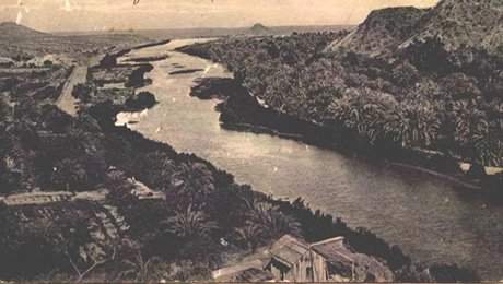
BEFORE

|
|
|
cervezafrio
Newbie
Posts: 19
Registered: 10-15-2010
Member Is Offline
|
|
WillyAir - Does that picture have a time stamp? Best guess. It is from town looking towards the lighthouse mound? Has any body done a recent Ariel
shot to compare. Thanks Stream
Footnote: if the conversation continues the thoughts and ideas are not lost or forgotten. Other wise it becomes a memory.
|
|
|
willyAirstream
Super Nomad
   
Posts: 1786
Registered: 1-1-2010
Member Is Offline
|
|
Still looking for a date.
Yes, looking at the lighthouse, from town.
Ariel pics are posted in one of the other dam threads.
Time to add that second story to your casa. The locals are snapping up the lots on high ground along light house road and in the hills beyond the
mission. The lots along the highway south of town are also being sold.
If you drive to the top of the mountains toward Paso Hondo, you can see that any dam would be gigantic, not going to happen.
Mulege is changing, moving forward. People are looking at alternate sources of income, instead of depending on tourism. A fertilizer plant has opened
up in the valley. The govt is sponsoring growing corn for ethanol here and there are Rumors of other non tourist industries starting.
|
|
|
cervezafrio
Newbie
Posts: 19
Registered: 10-15-2010
Member Is Offline
|
|
Ok I think I am getting the message.. As I mentioned before I am not the fastest. But . So it is the 5 gallon bucket approach, bail out the water as
fast as possible. Get to a point where a equilibrium is possible. Then abandon ship and go for high ground. Eventually all the river rats will either
learn to swim or be drown out. Since I alone can not bail out fast enough to empty the river valley, I will plug the hole, anchor a house boat to a
long line and ride the ups and downs of river bank living.. Thanks every body for your input.. I appreciate the sensible discussion with out all the
usual diversionary side / snide remarks... I well close with the old adage of '' stay high and dry '' . Which is more than relevant at this time and
space in life......
|
|
|
wetto
Nomad
 
Posts: 119
Registered: 10-28-2013
Location: Grass Valley, CA / Mulege
Member Is Offline
|
|
Any idea if they are going to reconnect the beachfront road (north river road) to the lighthouse and boat ramp?
As of last week there was a large (not passable) gap connecting the estuary to the sea. A lot of fill would be needed.
Anyone hear of any plans?
Lee S
|
|
|
Gulliver
Senior Nomad
  
Posts: 651
Registered: 11-18-2013
Member Is Offline
|
|
I'm riding my motorcycle out there later today. Will post the results.
|
|
|
alacran
Nomad
 
Posts: 316
Registered: 9-22-2011
Location: Mulege
Member Is Offline
|
|
In past years and floods, the northern winds of winter have helped to close that gap to the lighthouse.
|
|
|
Gulliver
Senior Nomad
  
Posts: 651
Registered: 11-18-2013
Member Is Offline
|
|
Just got back. Still a channel through the spit. The locals say that you can walk across at low tide but that doesn't sound like anything one would
want to negotiate with a wheeled vehicle. And the high ground on both sides is deep sand and gravel.
The North road, for those of you not driving it every day, has had a typical mexican treatment. A bunch of silt trucked in followed by a grader
followed by everyone driving fast even when it was wet from some rain.
It is probably better than it was a few weeks ago but not much. We'll see what transpires. They seem to be filling in the area behind the old concrete
malecon and, ust possibly, there we some final spasm of road building with a hard surface. One can only hope.
Just now the water department came and buried the last bit of exposed pipe just West of Jungla Jim's in front of Janine's on the South road. Of
course, they buried it about eight inches deep so give it a week before it starts leaking like the other six places along in front of the Oasis.
The coots really like drinking from the fresh water springs.
Always resources to patch things up but never to do it so it will last. Sigh.
|
|
|
| Pages:
1
2
3
4 |

