| Pages:
1
..
8
9
10
11
12
13 |
Ken Cooke
Elite Nomad
     
Posts: 8970
Registered: 2-9-2004
Location: Riverside, CA
Member Is Offline
Mood: Pole Line Road postponed due to injury
|
|
| Quote: | Originally posted by TW
Ken I'm trying to get you interested in it again. Remember the saying "out of sight out of mind". I'm going to check out parts of it next Thursday and
Friday. If I can get past the first road block S section I think my Tacoma could make it. Maybe an Ad deal with Toyota. "Toughest truck in the world,
it beats the Baja from mining fields and arroyos to rock covered mountains". Just a thought. They might not buy it since my truck is a 2004. But DKs
could be passed as a new one. |
Don't worry, amigo. I'm very interested in this route. It would be great if this route could be traveled by 4 wheel vehicles from the Gonzaga
vicinity to Hwy 1 and back. I want to take up any of the Baja Grande participants in traveling this route with me. Some may stay at the beach that
day, but the ones who are up for some decent rock crawling and trail scouting will have a wonderful time!
Trail Scouting for La Turquesa Trail in Nov. 2007

Visiting at the La Turquesa Mine with friends


|
|
|
BAJACAT
Ultra Nomad
    
Posts: 2902
Registered: 11-21-2005
Location: NATIONAL CITY, CA
Member Is Offline
|
|
bump
BAJA IS WHAT YOU WANTED TO BE, FUN,DANGEROUS,INCREDIBLE, REMOTE, EXOTIC..JUST GO AND HAVE FUN.....
|
|
|
TMW
Select Nomad
      
Posts: 10659
Registered: 9-1-2003
Location: Bakersfield, CA
Member Is Offline
|
|
Jose are you going to try it? When the squarecircle did it he walked it first from the mine area to the bottom of the hill where it gets out of the
wash and then marked it with ribbons back to the mine. We followed mostly the motorcycle path except in a few locations. It's two miles and stays on
the north side of the arroyo. There are two bad places, the first is right as you leave the mine area and is an S shaped turn. You would need to find
a way around because only a short wheelbase vehicle can make it like a Jeep, 4 runner or Xterra and even them it's tricky. I do think if we could get
a group together like the dirty 8 we could find a way for the full size vehicles to get thru. Might take a little road building.
|
|
|
Ken Cooke
Elite Nomad
     
Posts: 8970
Registered: 2-9-2004
Location: Riverside, CA
Member Is Offline
Mood: Pole Line Road postponed due to injury
|
|
View from the La Turquesa Mine sites.

Very rugged conditions

View of the massive arroyo that lies east of the trail down the mountainside

|
|
|
TMW
Select Nomad
      
Posts: 10659
Registered: 9-1-2003
Location: Bakersfield, CA
Member Is Offline
|
|
It's been three years since Roy made it thru. It would be interesting to see how much if any the wash has changed.
|
|
|
Ken Cooke
Elite Nomad
     
Posts: 8970
Registered: 2-9-2004
Location: Riverside, CA
Member Is Offline
Mood: Pole Line Road postponed due to injury
|
|
| Quote: | Originally posted by TW
It's been three years since Roy made it thru. It would be interesting to see how much if any the wash has changed. |
The next time you guys make it through, please record GPS waypoints as you travel through. That way, I can find my way from Gonzaga to Hwy 1.
|
|
|
BAJACAT
Ultra Nomad
    
Posts: 2902
Registered: 11-21-2005
Location: NATIONAL CITY, CA
Member Is Offline
|
|
| Quote: | Originally posted by TW
Jose are you going to try it? When the squarecircle did it he walked it first from the mine area to the bottom of the hill where it gets out of the
wash and then marked it with ribbons back to the mine. We followed mostly the motorcycle path except in a few locations. It's two miles and stays on
the north side of the arroyo. There are two bad places, the first is right as you leave the mine area and is an S shaped turn. You would need to find
a way around because only a short wheelbase vehicle can make it like a Jeep, 4 runner or Xterra and even them it's tricky. I do think if we could get
a group together like the dirty 8 we could find a way for the full size vehicles to get thru. Might take a little road building.
|
TW, Im just going to the pools and thats it..Maybe we can make that in a mission haunt type trip ..the other
truck is afull size too, so I don't think so, mayber I can do it on the 4runner(1990 4x4), that I bought, it's not Baja ready jet, it has street tires
I got it on Craigs list..maybe it will be ready for the next trip.
BAJA IS WHAT YOU WANTED TO BE, FUN,DANGEROUS,INCREDIBLE, REMOTE, EXOTIC..JUST GO AND HAVE FUN.....
|
|
|
Ken Cooke
Elite Nomad
     
Posts: 8970
Registered: 2-9-2004
Location: Riverside, CA
Member Is Offline
Mood: Pole Line Road postponed due to injury
|
|
Jose - Enjoy the pools, but don't destroy your vehicle trying to find the other end of the arroyo to reach Hwy 1. The route is extremely rugged, and
you can damage tires and drivetrain components with the rocky outcroppings that you will encounter in this canyon.
Trying to find the other side of the Canyon


|
|
|
BAJACAT
Ultra Nomad
    
Posts: 2902
Registered: 11-21-2005
Location: NATIONAL CITY, CA
Member Is Offline
|
|
| Quote: | Originally posted by Ken Cooke
Jose - Enjoy the pools, but don't destroy your vehicle trying to find the other end of the arroyo to reach Hwy 1. The route is extremely rugged, and
you can damage tires and drivetrain components with the rocky outcroppings that you will encounter in this canyon.
Trying to find the other side of the Canyon


 |
Thanks Ken,Im just driving to the pools thats it..thanks for the advise..
BAJA IS WHAT YOU WANTED TO BE, FUN,DANGEROUS,INCREDIBLE, REMOTE, EXOTIC..JUST GO AND HAVE FUN.....
|
|
|
David K
Honored Nomad
        
Posts: 65433
Registered: 8-30-2002
Location: San Diego County
Member Is Offline
Mood: Have Baja Fever
|
|
A Nomad asked about the road to the La Turquesa Canyon (green pools. turquoise mine, old mine grade up to Hwy. 1 by El Pedregoso boulder mountain...
Since Roy 'The Squarecircle' is the first documented to drive a four wheel drive Land Rover all the way across from Hwy. 5 to Hwy. 1 here (in recent
history), it seemed like a good time to bump this thread up for some good old Baja off roading adventure.
More on the Turquoise Mine here: http://vivabaja.com/wayno
Photo I took at the mine in 1975:

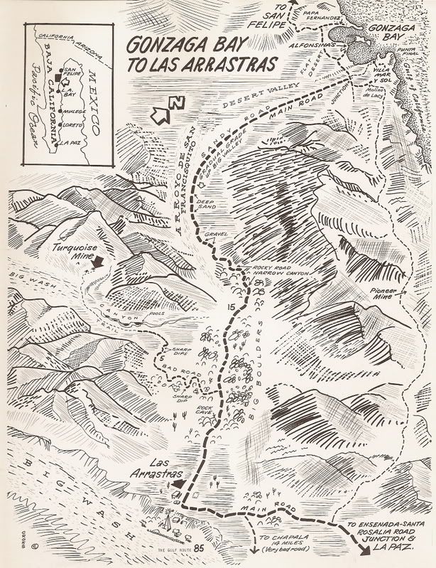
1970 map
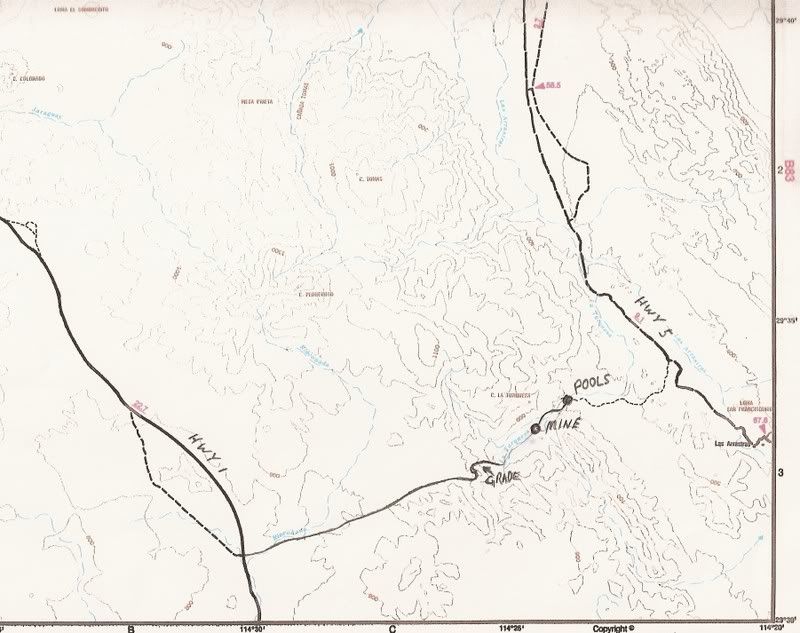
The area on topo map
|
|
|
David K
Honored Nomad
        
Posts: 65433
Registered: 8-30-2002
Location: San Diego County
Member Is Offline
Mood: Have Baja Fever
|
|
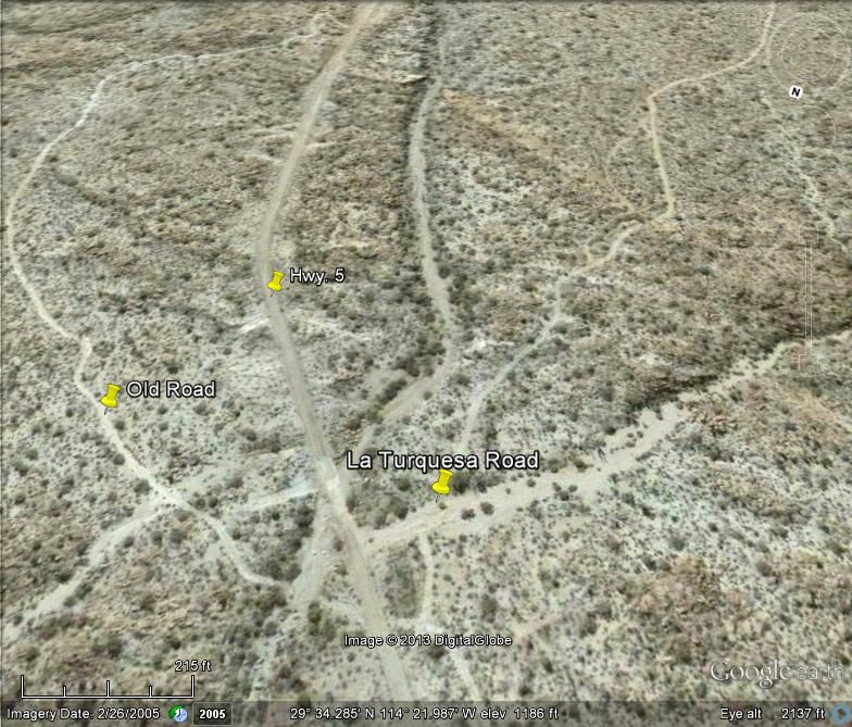
From Space:
North at top, unless otherwise noted...
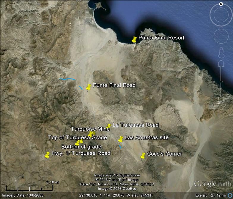
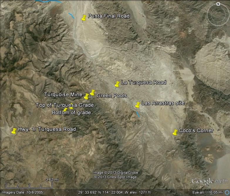
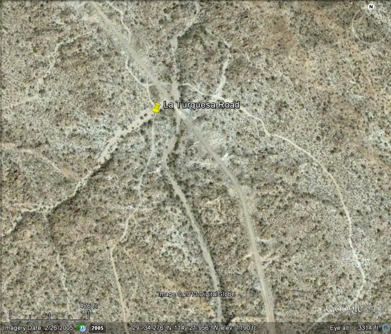
Looking South:
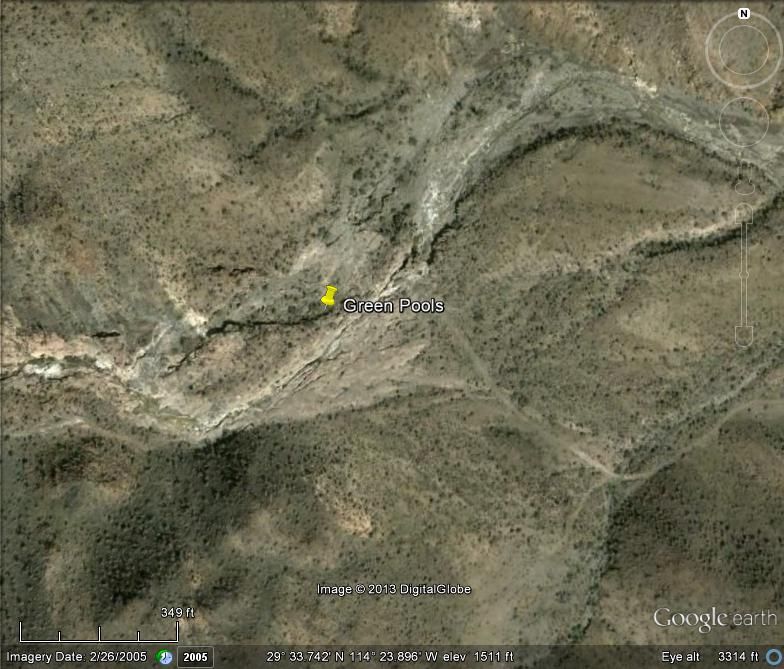
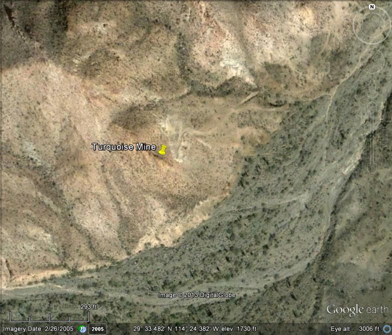
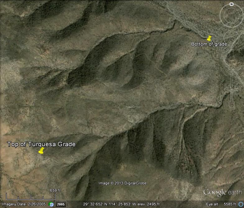
Looking west:
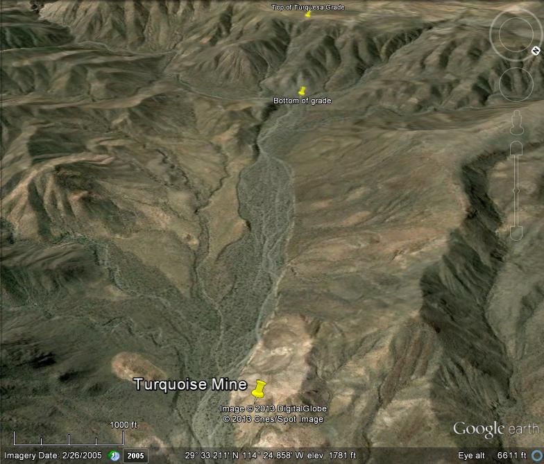
Looking at side of grade (north-west):
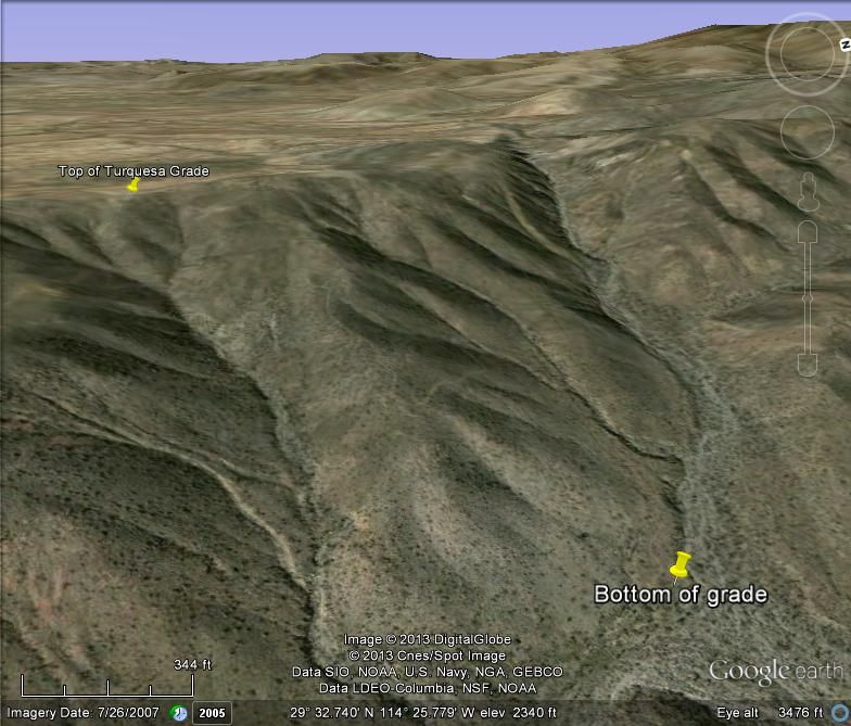
|
|
|
Ken Cooke
Elite Nomad
     
Posts: 8970
Registered: 2-9-2004
Location: Riverside, CA
Member Is Offline
Mood: Pole Line Road postponed due to injury
|
|
Baja Grande 2007
My crew traveling the Turquoise Mine Road.


|
|
|
BajaWarrior
Super Nomad
   
Posts: 2307
Registered: 9-27-2006
Location: Mission Bay, San Diego. Playa Hermosa, San Felipe.
Member Is Offline
Mood: Anxious to get south
|
|
What a coincedence you guys brought this old post up.
We were just at La Turquesa between Christmas and New Years.
My wife Chris and I left our Beach House in Playa Hermosa/Bahia Santa Maria early in the morning and traveled to Rancho Grande/Gonzaga Bay which is 73
miles door to door for us.
We parked at Rancho Grande and offloaded the ATV's and headed South. We found the turnoff to the mine and springs and headed up the canyon. We only
got as far as the mine but searched for a road in the riverbed but just like Matomi Canyon, it had been washed out pretty good from the summer rains.
I didn't know there was a road that goes to Highway 1 but now it all makes sense.
Also, it was freezing that day so we made this a pretty quick stop. Next we headed down to see Coco, and as usual there was a lot of activity. At this
point we were really cold and knew we had 20 miles North into the wind to make it back to the truck. We literally raced one another back to Rancho
Grande on the dirt highway.
The paved highway was in great shape but believe it or not, we're already seeing potholes on sections that were paved less than two years ago. Only
three miles remain unpaved to Gonzaga Bay. The army had the usual inspection, both ways, and we handed them a bunch of candy canes we had left over
from Christmas.
That's about it, except for the extreme cold, which got even colder at any speed on our ATV's, it was a great side trip. We mad it back to our house
in an hour and 40 minutes door to door.


[Edited on 1-15-2013 by BajaWarrior]
Haven't had a bad trip yet....
|
|
|
TMW
Select Nomad
      
Posts: 10659
Registered: 9-1-2003
Location: Bakersfield, CA
Member Is Offline
|
|
The road in the wash has been gone for several years. The only trail is from motorcycles passing thru. When the Squarecircle went thru in his SUV we
walked it the day before to where it went out of the wash and up the mtn then he marked the trail he was to take. It's about 2 miles in the wash and
there were two really hard spots and a couple of difficult spots but he got thru with no damage to his SUV. After getting out of the wash there is a
considerable amount of rocks to get over or around at the bottom of the mtn. An ATV would not have any problems getting thru and it would be a fun
trip. I don't recall the actual distance up the mtn, maybe a mile, but I think it is 4 to 5 miles to the highway from the top. A short wheelbase is
the key to getting thru as you have to navigate around some large rocks.
I should add that the rains during the last several years probably have changed everything. Time to check it out again.
[Edited on 1-15-2013 by TW]
|
|
|
David K
Honored Nomad
        
Posts: 65433
Registered: 8-30-2002
Location: San Diego County
Member Is Offline
Mood: Have Baja Fever
|
|
Chuck, Tom, or anyone: Did you get the mileage from the La Turquesa road to Coco's Corner or the Punta Final south road?
|
|
|
BajaWarrior
Super Nomad
   
Posts: 2307
Registered: 9-27-2006
Location: Mission Bay, San Diego. Playa Hermosa, San Felipe.
Member Is Offline
Mood: Anxious to get south
|
|
| Quote: | Originally posted by David K
Chuck, Tom, or anyone: Did you get the mileage from the La Turquesa road to Coco's Corner or the Punta Final south road? |
11 miles David from Rancho Grande.
The cutoff for La Turquesa is in a "vado" and literally the only tracks to the West along the "highway".
Haven't had a bad trip yet....
|
|
|
Tacodawgtim
Junior Nomad

Posts: 90
Registered: 9-15-2012
Location: San Felipe. Full time
Member Is Offline
Mood: No Bad Days
|
|
I am getting ready to head back to San Felipe in a couple weeks. Ill be there for a couple months. Ill definitely have to look into the road, or
trail. Sounds like a ride for a jeep or Toyota, luckily I'll have both down there. Ill try to send back more pictures. Just need to find another
vehicle to go. I know the way down is no problem it's just once you turn off road.
|
|
|
TMW
Select Nomad
      
Posts: 10659
Registered: 9-1-2003
Location: Bakersfield, CA
Member Is Offline
|
|
| Quote: | Originally posted by David K
Chuck, Tom, or anyone: Did you get the mileage from the La Turquesa road to Coco's Corner or the Punta Final south road? |
It's 7.5 miles from the mine road turnoff to Cocos.
|
|
|
David K
Honored Nomad
        
Posts: 65433
Registered: 8-30-2002
Location: San Diego County
Member Is Offline
Mood: Have Baja Fever
|
|
| Quote: | Originally posted by TW
| Quote: | Originally posted by David K
Chuck, Tom, or anyone: Did you get the mileage from the La Turquesa road to Coco's Corner or the Punta Final south road? |
It's 7.5 miles from the mine road turnoff to Cocos. |

Eureka, I found my mileage notes from 2011 and the distance to Coco's Corner is exactly the same as TW's. However, the distance to Rancho Grande/
Gonzaga Pemex is more than Chuck's...?
Total (and partial) mileages from San Luis Gonzaga
00.0 (0.0) Rancho Grande Store, Gonzaga (across from Pemex)
01.2 (1.2) Campo Beluga and El Sacrificio road
04.9 (3.7) Arroyo Santa Maria
07.2 (2.3) Las Palmitas/Santa Maria Canyon road
09.7 (2.5) Punta Final road
14.6 (4.9) La Turquesa road
18.4 (3.8) Las Arrastras road
22.1 (3.7) Coco's Corner
34.8 (12.7) Hwy. 1, Laguna Chapala
|
|
|
TMW
Select Nomad
      
Posts: 10659
Registered: 9-1-2003
Location: Bakersfield, CA
Member Is Offline
|
|
If a usable road was built thru there one would save a lot of time to Gonzaga instead of going around by Cocos. Maybe the new paved hwy will go that
way. Wouldn't that be interesting.
FYI DK I got the milage from your road log. Ha Ha
|
|
|
| Pages:
1
..
8
9
10
11
12
13 |

