| Pages:
1
..
9
10
11
12
13 |
BajaWarrior
Super Nomad
   
Posts: 2307
Registered: 9-27-2006
Location: Mission Bay, San Diego. Playa Hermosa, San Felipe.
Member Is Offline
Mood: Anxious to get south
|
|
| Quote: | Originally posted by David K
| Quote: | Originally posted by TW
| Quote: | Originally posted by David K
Chuck, Tom, or anyone: Did you get the mileage from the La Turquesa road to Coco's Corner or the Punta Final south road? |
It's 7.5 miles from the mine road turnoff to Cocos. |

Eureka, I found my mileage notes from 2011 and the distance to Coco's Corner is exactly the same as TW's. However, the distance to Rancho Grande/
Gonzaga Pemex is more than Chuck's...?
Total (and partial) mileages from San Luis Gonzaga
00.0 (0.0) Rancho Grande Store, Gonzaga (across from Pemex)
01.2 (1.2) Campo Beluga and El Sacrificio road
04.9 (3.7) Arroyo Santa Maria
07.2 (2.3) Las Palmitas/Santa Maria Canyon road
09.7 (2.5) Punta Final road
14.6 (4.9) La Turquesa road
18.4 (3.8) Las Arrastras road
22.1 (3.7) Coco's Corner
34.8 (12.7) Hwy. 1, Laguna Chapala |
Allright, you got me. I merely thought it said 11 miles on my wife's ATV odometer, bad memory probably...
Haven't had a bad trip yet....
|
|
|
David K
Honored Nomad
        
Posts: 65433
Registered: 8-30-2002
Location: San Diego County
Member Is Offline
Mood: Have Baja Fever
|
|
Tom, no fair if I check my odometer against yours, if it wasn't yours, but was mine? LOL
Chuck, it's all good! It is the only road to the west between the Punta Final junction and Las Arrastras... and you can see the vado in the road where
the Turquesa trail leads off. Thank you!
|
|
|
4x4abc
Ultra Nomad
    
Posts: 4454
Registered: 4-24-2009
Location: La Paz, BCS
Member Is Offline
Mood: happy - always
|
|
la turquesa
cool trail!
Drove it for the first time about 1992 (Mercedes 300GD 4x4). Finding a path through the wash was annoying but not difficult.
Guided some friends a few weeks ago again - this time it was like a freeway. Well, kind of. Took about 3 hours for the 2 miles in the wash.
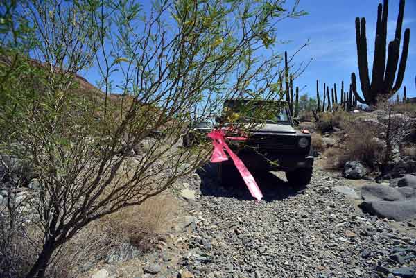
Thanks for the ribbons! Now even a blind driver can find the trail.
The short grade is about 30 degrees - not 45 as posted earlier. 45 degrees (100% grade) on dirt would not be possible to drive.
The first section after the grade is pretty rocky. No signs of recent truck travel - bikes only
Here is the latest GPS record: http://rubicon-trail.com/Rubicon.Trail.GPS/la.turquesa.GPX
Harald Pietschmann
|
|
|
Ken Cooke
Elite Nomad
     
Posts: 8970
Registered: 2-9-2004
Location: Riverside, CA
Member Is Offline
Mood: Pole Line Road postponed due to injury
|
|
For reference, a 30 degree sidehill section constitutes either a 'moderate' or 'difficult' 4WD trail according to the Mile High Jeep Club.
link:
http://www.mhjc.org/page26.html
|
|
|
4x4abc
Ultra Nomad
    
Posts: 4454
Registered: 4-24-2009
Location: La Paz, BCS
Member Is Offline
Mood: happy - always
|
|
Ken,
it's a grade not a sidehill. A 30+ degree grade is a "9" (difficult) on their list. It sure ain't easy!
Harald Pietschmann
|
|
|
Barry A.
Select Nomad
      
Posts: 10007
Registered: 11-30-2003
Location: Redding, Northern CA
Member Is Offline
Mood: optimistic
|
|
| Quote: | Originally posted by 4x4abc
Ken,
it's a grade not a sidehill. A 30+ degree grade is a "9" (difficult) on their list. It sure ain't easy! |
For comparison, I think I remember that State highway grades are max. 6% in most cases, with an 8% max. in extremely rare cases.
Barry
|
|
|
Ken Cooke
Elite Nomad
     
Posts: 8970
Registered: 2-9-2004
Location: Riverside, CA
Member Is Offline
Mood: Pole Line Road postponed due to injury
|
|
| Quote: | Originally posted by 4x4abc
Ken,
it's a grade not a sidehill. A 30+ degree grade is a "9" (difficult) on their list. It sure ain't easy! |
The Colorado Jeep Club probably don't encounter grades of this intensity on their trails. I encountered a very steep section of the Summit trail
traveling up to the Parque Constitucion - all you could see was your hood and blue sky, a rocky wall to your left, and a cliff/drop off to your right.
I'll probably never forget the North Summit for this reason. 
|
|
|
David K
Honored Nomad
        
Posts: 65433
Registered: 8-30-2002
Location: San Diego County
Member Is Offline
Mood: Have Baja Fever
|
|
Of interest, I just heard from a 'Baja brother' that the La Turquesa Grade, (which looked like an old mine road to me), might actually have been built
by Fred Hampe, the foreman of Rancho Santa Ynez, years ago (he built the Mission Santa María road starting in the late 1950's)!
The original idea was to connect Santa Ynez with Punta Final (Gonzaga) which was owned by the same lady who owned Santa Ynez (Josefina Zunigo). Two
miles east, beyond the mission, at the edge of a deep canyon, that road project was abandoned due to impossible terrain for the equipment they had.
The highway was completed, reducing the travel time going the long way around to Gonzaga (via Calamajué Canyon first, then the new Chapala to Puerto
Calamajué road after 1983). Josefina had asked the president of Mexico to build the highway to Gonzaga via Santa María. She got a paved 3/4 mile long
driveway and paved airstrip.
The La Turquesa Canyon road would be a great short cut to Gonzaga from Santa Ynez. However, flash floods must have really done a number on the 1-2
miles or so from the bottom of the grade to the turquoise mine. It wouldn't surprise me if Fred Hampe did make this short cut, after all!
|
|
|
David K
Honored Nomad
        
Posts: 65433
Registered: 8-30-2002
Location: San Diego County
Member Is Offline
Mood: Have Baja Fever
|
|
| Quote: | Originally posted by 4x4abc
cool trail!
Drove it for the first time about 1992 (Mercedes 300GD 4x4). Finding a path through the wash was annoying but not difficult.
Guided some friends a few weeks ago again - this time it was like a freeway. Well, kind of. Took about 3 hours for the 2 miles in the wash.
Thanks for the ribbons! Now even a blind driver can find the trail.
The short grade is about 30 degrees - not 45 as posted earlier. 45 degrees (100% grade) on dirt would not be possible to drive.
The first section after the grade is pretty rocky. No signs of recent truck travel - bikes only
Here is the latest GPS record: http://rubicon-trail.com/Rubicon.Trail.GPS/la.turquesa.GPX |
Hi Harald,
Can you fix that link? I would enjoy seeing the track map. Do you have a mileage from the mine to the bottom of the grade?
[Edited on 5-11-2014 by David K]
|
|
|
4x4abc
Ultra Nomad
    
Posts: 4454
Registered: 4-24-2009
Location: La Paz, BCS
Member Is Offline
Mood: happy - always
|
|
David,
link works just fine (tell your computer to save that link)
http://baja101.com/Baja-GPS/la.turquesa.gpx
http://baja101.com/Baja-GPS/la.turquesa.kmz
I recorded 1.8 miles from the mine to the grade

Harald Pietschmann
|
|
|
4x4abc
Ultra Nomad
    
Posts: 4454
Registered: 4-24-2009
Location: La Paz, BCS
Member Is Offline
Mood: happy - always
|
|
distance from bottom of grade to the highway is 5.6 miles

Harald Pietschmann
|
|
|
4x4abc
Ultra Nomad
    
Posts: 4454
Registered: 4-24-2009
Location: La Paz, BCS
Member Is Offline
Mood: happy - always
|
|
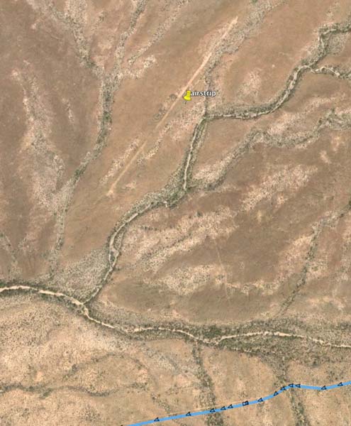
and for all you Google Earth fans - close to the road connecting to the highway is an abandoned airstrip.
No surprise, as most mines in Baja have an airstrip.
Harald Pietschmann
|
|
|
4x4abc
Ultra Nomad
    
Posts: 4454
Registered: 4-24-2009
Location: La Paz, BCS
Member Is Offline
Mood: happy - always
|
|
save the planet - shoot yourself
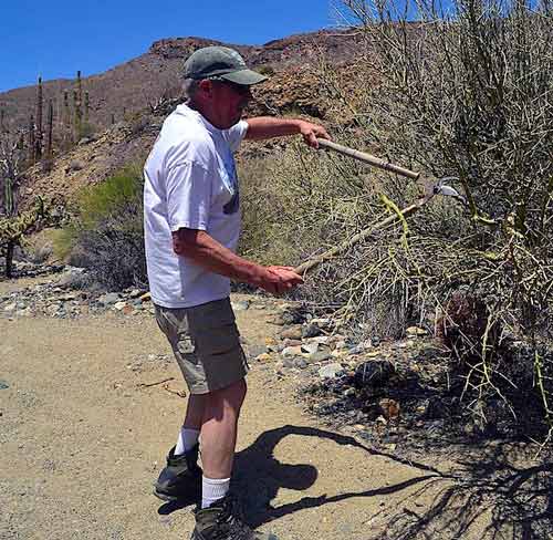
for the environmentally sensitive among you - no rocks have been moved, no ramps have been built,no spinning tires scared the ground. However, some of
the bushes were in for a little pruning. They told us that they felt so much better about themselves now.
for the car lovers among you - no tires have been damaged, no parts failed, nothing was broken. However, some of the unpruned bushes (jealous
bastards!) attacked our paint jobs.
since nobody cares about humans any more, I say it anyway: we had a great time, sufficient food and free flowing beer. Yes, we drank and drove. It was
good, man!
Harald Pietschmann
|
|
|
tripledigitken
Ultra Nomad
    
Posts: 4848
Registered: 9-27-2006
Member Is Offline
|
|
Harald,
What type of vehicles successfully made the trek with you?
|
|
|
4x4abc
Ultra Nomad
    
Posts: 4454
Registered: 4-24-2009
Location: La Paz, BCS
Member Is Offline
Mood: happy - always
|
|
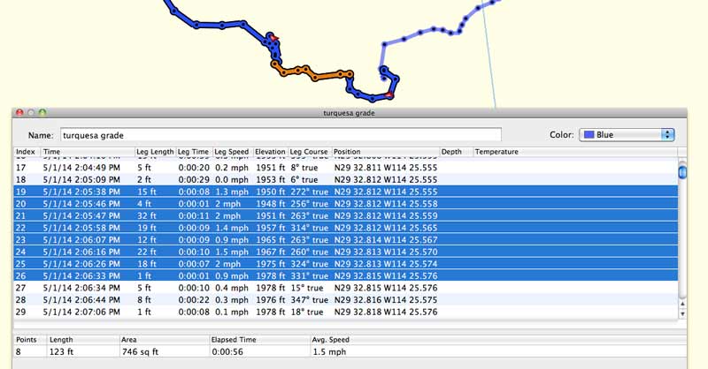
Garmin BaseCamp
highly recommend Garmin BaseCamp to get more out of your gdb or gpx files - and it's free!
http://www.garmin.com/en-US/shop/downloads/basecamp
You can crunch numbers when back at home like where you stopped, how fast you were going in which spot.
My recorded track shows me that I drove the steep grade at about 1.5 mph and that it is roughly 30 feet high.
Harald Pietschmann
|
|
|
4x4abc
Ultra Nomad
    
Posts: 4454
Registered: 4-24-2009
Location: La Paz, BCS
Member Is Offline
Mood: happy - always
|
|
vehicles in group:
Jeep Wrangler TJ, 33" tires, ARB front and rear
Nissan pickup (no clue which model), 33" tires, rear locker only
Mercedes G500, 295/75R16, 3 diff locks
[Edited on 5-11-2014 by 4x4abc]
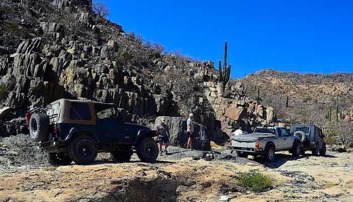
Harald Pietschmann
|
|
|
4x4abc
Ultra Nomad
    
Posts: 4454
Registered: 4-24-2009
Location: La Paz, BCS
Member Is Offline
Mood: happy - always
|
|
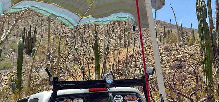
grade
the following image shows the steepness of the grade pretty well - it is STEEP!
[Edited on 5-11-2014 by 4x4abc]
[Edited on 5-11-2014 by 4x4abc]
Harald Pietschmann
|
|
|
durrelllrobert
Elite Nomad
     
Posts: 7393
Registered: 11-22-2007
Location: Punta Banda BC
Member Is Offline
Mood: thriving in Baja
|
|
Highschool trig
| Quote: | Originally posted by Barry A.
| Quote: | Originally posted by 4x4abc
Ken,
it's a grade not a sidehill. A 30+ degree grade is a "9" (difficult) on their list. It sure ain't easy! |
For comparison, I think I remember that State highway grades are max. 6% in most cases, with an 8% max. in extremely rare cases.
Barry |
When the highway sign states "6% grade next mile" the change in altitude is 552 ft (5280 ft x Sin 6 degrees or .10453). When the sign says 8% grade
next mile the change in altitude is 735 ft.
For a 100 ft long 30 degree grade the change in altitude is 50 feet (100 ft x Sin 30 degrees or .5000)
Bob Durrell
|
|
|
David K
Honored Nomad
        
Posts: 65433
Registered: 8-30-2002
Location: San Diego County
Member Is Offline
Mood: Have Baja Fever
|
|
Thank you Harald... The links open up a page full of computer text when I click on it, and that is a first for me. I appreciate the GE track... I have
been from Hwy. 1 to the top of the grade, then walked about 1/3 of the way down it. I have also been to the green pools and hiked to the turquoise
mine (in 1975) as I did not see that the road was on the big flat rock from the green pools.
I hope Roy (The Squarecircle) sees this!
|
|
|
TMW
Select Nomad
      
Posts: 10659
Registered: 9-1-2003
Location: Bakersfield, CA
Member Is Offline
|
|
Ken, you and your jeep friends should give La Turquesa a try.
|
|
|
| Pages:
1
..
9
10
11
12
13 |

