| Pages:
1
2
3 |
vacaenbaja
Senior Nomad

Posts: 644
Registered: 4-4-2006
Member Is Offline
|
|
So David I was just re reading Arthur North's book. I find it interesting that even with the advance knowledge of the
scarcity of water past the Santo Domingo area both
Arthur North as well as Hale and Moore of "A Long walk to Mulege" Almost died of thirst trying to reach San Ignacio.
Do you have any idea of which "camino" North took when
they stumbled into San Ignacio? He said that the natives were surprised that he came in by way of the road less taken
rather that the more commonly traveled road of that time.
Just prior to entering San Ignacio North said that he saw signs of rocks that outlined " El camino" as well as a few road side graves.
|
|
|
David K
Honored Nomad
Posts: 65562
Registered: 8-30-2002
Location: San Diego County
Member Is Offline
Mood: Have Baja Fever
|
|
North traveled from Santa Gertrudis (where he left the Camino Real) for Calmalli (near El Arco) to obtain a guide to find for the antelope country
across the Vizcaino Desert.... to Ojo de Liebre, water hole 20 leagues from Calmalli. Ojo de Liebre to San Angel was 24 leagues apart. San Angel to
San Ignacio was 10 leagues. Just two water holes in 162 miles of desert. A league is the distance a man walks in one hour (North's League is 3 miles
long, a Spanish league of the 1700's was closer to 2.5 miles).
There were many mission roads (El Camino Reales) radiating out from missions, such as the case at San Ignacio. A look at Google Earth will reveal
many. These roads led to other missions, visitas (sub-mission stations), rancherias (Indian villages), supply ports on the ocean or gulf coast.
|
|
|
David K
Honored Nomad
Posts: 65562
Registered: 8-30-2002
Location: San Diego County
Member Is Offline
Mood: Have Baja Fever
|
|
| Quote: | Originally posted by Cisco
Neat, neat, neat.
Gracias for the thread and research David. Fascinating stuff. |
Glad you like this... I think the amount of history and exploration Baja has to offer makes it the greatest place on Earth for us outdoor adventure
seekers!
|
|
|
David K
Honored Nomad
Posts: 65562
Registered: 8-30-2002
Location: San Diego County
Member Is Offline
Mood: Have Baja Fever
|
|
| Quote: | Originally posted by Mexitron
| Quote: | Originally posted by David K
Sure there were roads... for mules, burros, horses, some may have allowed wagons... The first automobiles to travel south of El Marmol to San Ignacio
were in the 1920's.
The Camino Real was the 'mission road' created from the late 1600's to 1834 (the year the last mission was founded in 'California'. The 1907 maps in
this thread show Arthur North's rides on some of the mission roads and other trails. |
I know---I put roads in quotes, as per the map's symbol for automobile roads!
Have any pics of that era? Be neat to compare any plant growth seen in the last hundred years, as per your other thread... |
Hi Steve,
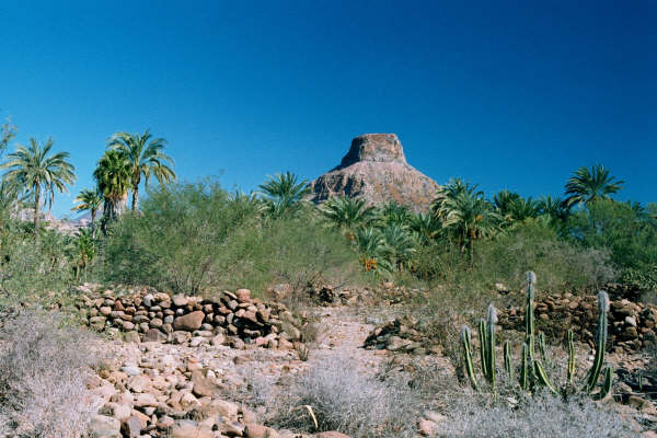
Yes it would be neat to compare... the best is to find a photo taken at the same place separated by many years. Remember the lost mission site made
famous by Choral Pepper in 1966, and then my photos there in 2009... virtually no change in growth over 40 years.... just a little. I am not sure if
the old photo locations taken by North are easy to find again in today's world?
Even buildings vanish!
La Purisima Mission:
1906 (North):

1956 (Gulick):

2001 (Swords):
|
|
|
David K
Honored Nomad
Posts: 65562
Registered: 8-30-2002
Location: San Diego County
Member Is Offline
Mood: Have Baja Fever
|
|
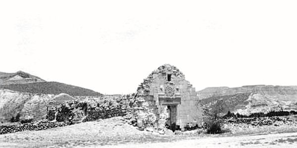
1926 La Purisima Mission Photo
|
|
|
PCmaps
Newbie
Posts: 7
Registered: 2-5-2014
Location: South Gate, CA
Member Is Offline
|
|
| Quote: | Originally posted by David K
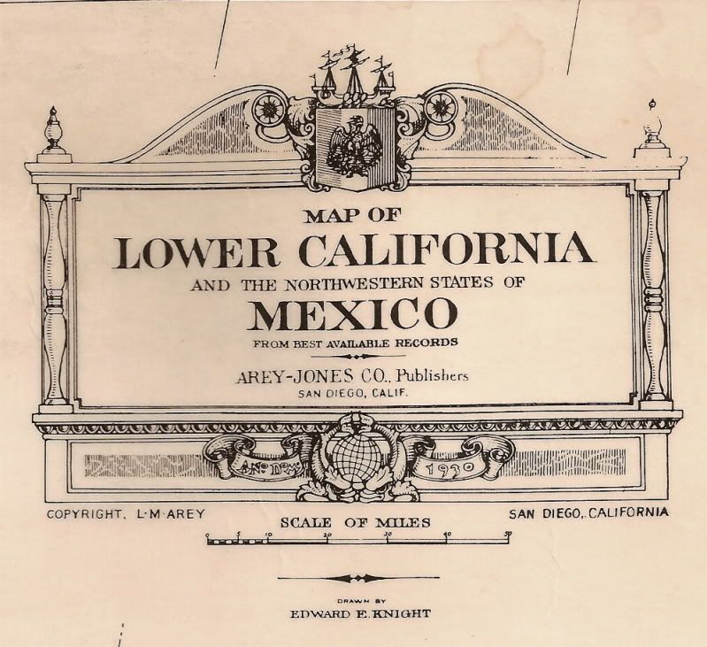
Sure... there were paddle boats that brought supplies off loaded at 'Port Isabel', Sonora to Yuma, Arizona! Port Isabel was at the mouth of the river,
north of El Golfo. There were shipyards there... may be an interesting place to explore?
See it on the right edge of this 1930 map:
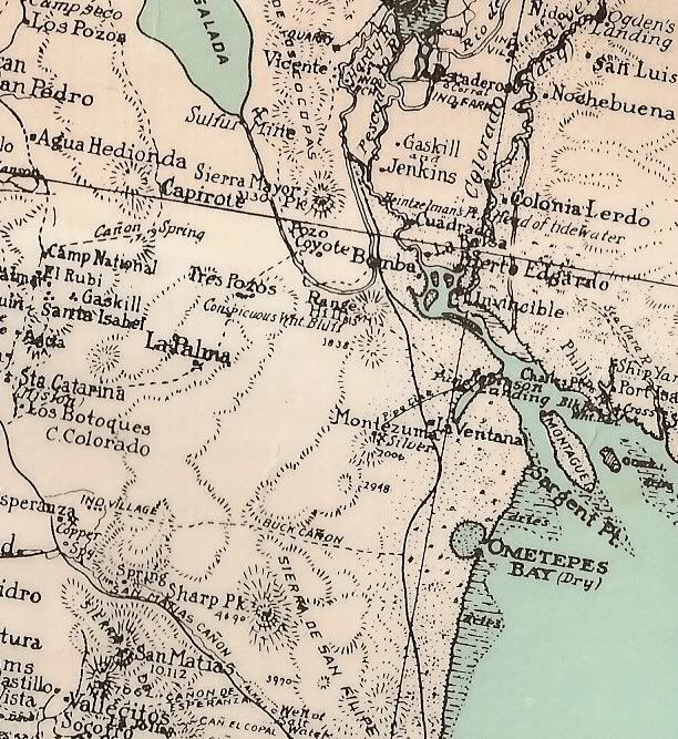
[Edited on 4-3-2013 by David K] |
First post, so hope I got this right . . .
I've been doing a bit of research on the Colorado Delta, originally trying to find where the Colorado River broke thru to form the Salton Sea, &
lately trying to find Port Isabel.
Think I've got the general area, here:
http://wikimapia.org/#lang=en&lat=31.789397&lon=-114...
Just west of the old Meritech Shrimp plant. Anybody ever been in this area?
|
|
|
PCmaps
Newbie
Posts: 7
Registered: 2-5-2014
Location: South Gate, CA
Member Is Offline
|
|
Well, link didn't seem to work, but if you go to Wikimapia, & wander down to just northeast of Isla Montague, you should see a small polygon where
I've marked out about where I think Port Isabel might have been. Click on the polygon, & you should get a short write-up.
Love to visit, but there doesn't seem any easy approach. Appears you could get semi close by accessing the old shrimp plant, but appears from Google
maps there is a locked gate blocking entrance to the shrimp plant . . .
John
|
|
|
David K
Honored Nomad
Posts: 65562
Registered: 8-30-2002
Location: San Diego County
Member Is Offline
Mood: Have Baja Fever
|
|
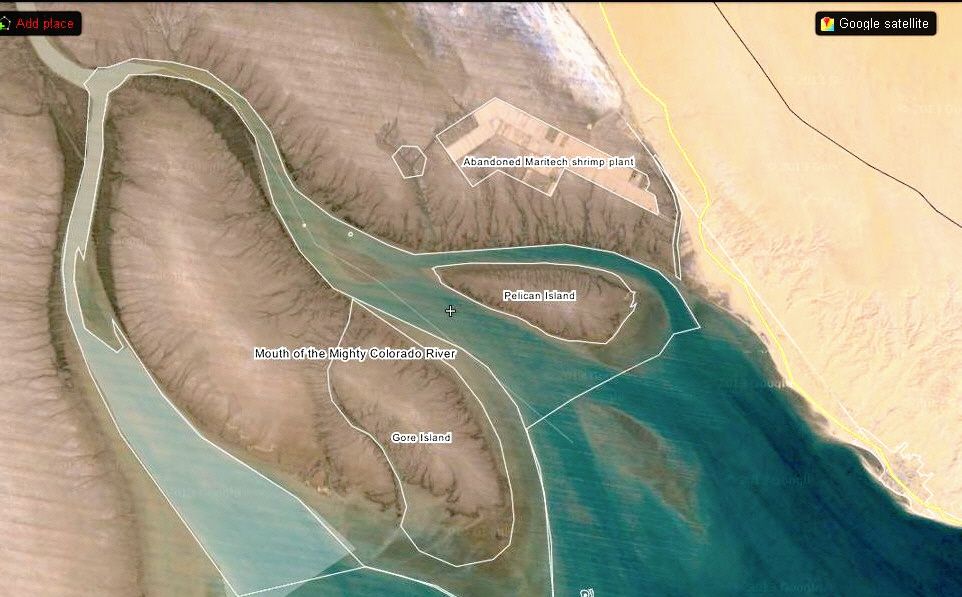
| Quote: | Originally posted by PCmaps
Well, link didn't seem to work, but if you go to Wikimapia, & wander down to just northeast of Isla Montague, you should see a small polygon where
I've marked out about where I think Port Isabel might have been. Click on the polygon, & you should get a short write-up.
Love to visit, but there doesn't seem any easy approach. Appears you could get semi close by accessing the old shrimp plant, but appears from Google
maps there is a locked gate blocking entrance to the shrimp plant . . .
John |
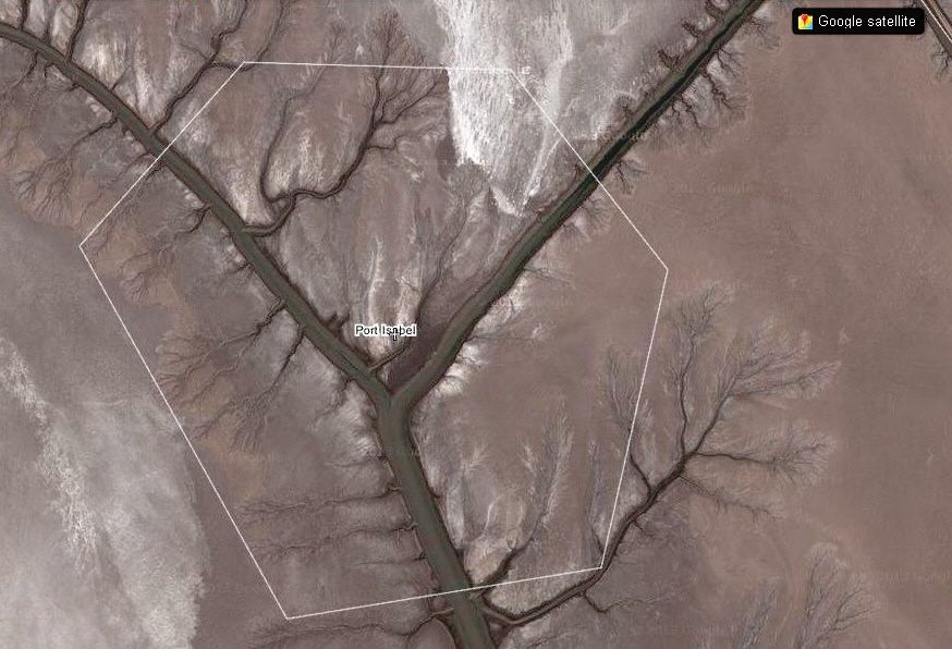
Welcome to Baja Nomad! Baja is a land full of adventures in exploration, history and discovery...
Here is the area of your Port Isabel from high up and then close up. This is not far from the highway to El Golfo. In my quick look, I did not see any
signs of construction for the old port. Did you?
[Edited on 7-29-2025 by David K]
|
|
|
PCmaps
Newbie
Posts: 7
Registered: 2-5-2014
Location: South Gate, CA
Member Is Offline
|
|
I've read everything I can find on Port Isabel (which admittedly hasn't been much . . .) and looked at a number of old maps ( the maps posted here
have been really neat). As best I can guess, Port Isabel is somewhere in the polygon I drew on Wikimapia. But alas, I have scoured Google Maps as
closely as possible, and I really can't make out any sign of the old port . . .
In her pretty interesting book "Salt Dreams: Land and Water in Low-Down California" Joan Myers has a couple of photos she took of what remains of Port
Isabel, and there are a few pilings, posts, and quays remaining, which does have me wondering if my guessed location is correct . . .
|
|
|
David K
Honored Nomad
Posts: 65562
Registered: 8-30-2002
Location: San Diego County
Member Is Offline
Mood: Have Baja Fever
|
|
PCmaps, have you researched the creation of the Salton Sea (you asked earlier)?
http://saltonseamuseum.org/salton_sea_history.html
Here are some dates:
1901: Imperial Canal brings water from the Colorado River to the Imperial Valley.
1904: Silt blocks the Imperial Canal preventing it from supplying water to the Imperial Valley.
1905: Temporary diversion of the Colorado River, constructed to replace water from the blocked canal, is breached by floodwaters. River changes course
and flows into Salton Sink.
1906: Floodwaters continue to fill Salton Sea, washing away a chain of lakes along the route and threatening Imperial Valleys fledgling agriculture
industry.
1906: George Wharton James explores the flooded areas and reports seeing large concentrations of waterfowl, pelicans and other birds in the Salton Sea
area.
1906: The Salton Sea is recorded at -195 feet below sea level.
1907: Floodwaters continue to fill Salton Sea until in February Southern Pacific Railroad closes the river breach.
In the 1960's my parents and used to go to the Salton Sea for boat races (Salton Sea 500... by dad and sister raced in before my time), for boating
and fishing (Corvina transplanted from San Felipe).
The sea slowly got saltier and began to kill off the fish... ag runoff containing fertilizers added to the poisoning and raised the once static sea
level. It is now pretty much a dead sea. The smell of dead fish along the shore keeps many folks away!
|
|
|
PCmaps
Newbie
Posts: 7
Registered: 2-5-2014
Location: South Gate, CA
Member Is Offline
|
|
Thats a really interesting site! First pic I've seen of the New Liverpool Salt Works in operation, and a good pic of the railroad cars dumping rock
to dam the flow of the Colorado and restore the river to its orig southward course to the Sea of Cortez.
Yrs ago, I'd heard that the Colorado broke thru its banks & turned west to form the Salton Sea, and I'd always wanted to find the spot where the
river broke thru. Expecting some giant ravine (like the New River in Mexicali), I ventured down to the border, but really couldn't find any physical
remnant. After a bit of research, I was finally able to locate the exact location, which I marked up on Wikimapia:
http://wikimapia.org/#lang=en&lat=32.671532&lon=-114...
I also posted up some info on the Alamo Canal, and marked up the locations of the spur tracks used by the railroad to close the breach, and the
various control structures that used to exist on the canal. Even found Sharps Heading at the western end of the Alamo Canal - lots of fun!
http://wikimapia.org/#lang=en&lat=32.662256&lon=-115...
If you click on the various points of interest, a short paragraph will appear with some info on the location.
Though there is no big ravine at the site of the breach, there still is a surprising amt left to be seen.
John
|
|
|
PCmaps
Newbie
Posts: 7
Registered: 2-5-2014
Location: South Gate, CA
Member Is Offline
|
|
Not sure why the links don't work . . . sorry. Might have to copy & paste them; or just go to Wikimapia & wander down to the area just south
of the Morelos Dam - lots of things highlighted in the area having to do w/ the Alamo Canal and the diversion of the Colorado River into the Canal,
which diversion formed the Salton Sea.
Probably the farmers in Brawley wouldn't be too happy, but had they failed to seal the breach, today we'd have an awesome freshwater lake instead of
the stinking cesspool the Salton Sea has become . . .
|
|
|
David K
Honored Nomad
Posts: 65562
Registered: 8-30-2002
Location: San Diego County
Member Is Offline
Mood: Have Baja Fever
|
|
| Quote: | Originally posted by PCmaps
Not sure why the links don't work . . . sorry. Might have to copy & paste them; or just go to Wikimapia & wander down to the area just south
of the Morelos Dam - lots of things highlighted in the area having to do w/ the Alamo Canal and the diversion of the Colorado River into the Canal,
which diversion formed the Salton Sea.
Probably the farmers in Brawley wouldn't be too happy, but had they failed to seal the breach, today we'd have an awesome freshwater lake instead of
the stinking cesspool the Salton Sea has become . . . |
Long links with too many characters need to be posted using this button, just above where you type in your posts (not Quick Reply):

Just enter a name for the link and then paste the link url in the spot provided.
Here are your two links:
Colorado River Broke Through Here
Sharps Heading, Alamo Canal
|
|
|
PCmaps
Newbie
Posts: 7
Registered: 2-5-2014
Location: South Gate, CA
Member Is Offline
|
|
| Quote: | Originally posted by David K
Sure... there were paddle boats that brought supplies off loaded at 'Port Isabel', Sonora to Yuma, Arizona! Port Isabel was at the mouth of the river,
north of El Golfo. There were shipyards there... may be an interesting place to explore?
See it on the right edge of this 1930 map:
[Edited on 4-3-2013 by David K] |
Sir David: Am actually looking for Port Isabel . . . hope to make it down later this month.
Anyone else have any old maps that might show Port Isabel?
Also, I plan to take two cars - one to drive on the mud flats, and another car to drive home (in case I can't get the first one back off the mud
flats).
US State Dept, though, says
"Mexican law requires that only owners drive their vehicles, or that the owner be inside the vehicle. If not, the vehicle may be seized by Mexican
customs and will not be returned under any circumstances"
I own both cars . . .
|
|
|
mtgoat666
Platinum Nomad
Posts: 21089
Registered: 9-16-2006
Location: San Diego
Member Is Offline
Mood: Hot n spicy
|
|
| Quote: | Originally posted by PCmaps
Sir David: Am actually looking for Port Isabel . . . hope to make it down later this month.
Anyone else have any old maps that might show Port Isabel?
Also, I plan to take two cars - one to drive on the mud flats, and another car to drive home (in case I can't get the first one back off the mud
flats).
|
that was once an active delta, when it was a river. now is inter tidal mud flats and a delta once per decade. the maps were probably only
approximate when made, and since then the mudflats have most certainly changed, shifted many kilometers due to subsidence, storm erosion/deposition,
etc. if you really want to find the place, spend time talking with locals and follow their clues - if remains exist, they will know. following map
likely to be fruitless.
and plan to drive out there? good luck!
please dont treat your second vehicle as disposable on the mudflats, it just adds blight and trash to the natural environment...
|
|
|
PaulW
Ultra Nomad
Posts: 3113
Registered: 5-21-2013
Member Is Offline
|
|
DK,
What is the 1930 map ref? By Who?
PW
=========
| Quote: | Originally posted by David K
Sure... there were paddle boats that brought supplies off loaded at 'Port Isabel', Sonora to Yuma, Arizona! Port Isabel was at the mouth of the river,
north of El Golfo. There were shipyards there... may be an interesting place to explore?
See it on the right edge of this 1930 map:
[Edited on 4-3-2013 by David K] |
|
|
|
weebray
Super Nomad
Posts: 1094
Registered: 7-19-2010
Location: La Paz
Member Is Offline
Mood: lleno
|
|
DK. Before we moved to Baja we spent some time in the UC Irvine library "special collections" looking at old books and maps of Baja. Their
collection includes some interesting items I have never seen. If you're in the area you may want to check it out here:
http://antpac.lib.uci.edu/search/X?SEARCH=baja+california+ma...
Every beautiful beach in the world needs a few condo towers - NOT.
|
|
|
PCmaps
Newbie
Posts: 7
Registered: 2-5-2014
Location: South Gate, CA
Member Is Offline
|
|
| Quote: | Originally posted by mtgoat666
| Quote: | Originally posted by PCmaps
Sir David: Am actually looking for Port Isabel . . . hope to make it down later this month.
Anyone else have any old maps that might show Port Isabel?
Also, I plan to take two cars - one to drive on the mud flats, and another car to drive home (in case I can't get the first one back off the mud
flats).
|
that was once an active delta, when it was a river. now is inter tidal mud flats and a delta once per decade. the maps were probably only
approximate when made, and since then the mudflats have most certainly changed, shifted many kilometers due to subsidence, storm erosion/deposition,
etc. if you really want to find the place, spend time talking with locals and follow their clues - if remains exist, they will know. following map
likely to be fruitless.
and plan to drive out there? good luck!
please dont treat your second vehicle as disposable on the mudflats, it just adds blight and trash to the natural environment...
|
I too would think an old map might be fuitless, but surprisingly, the slough Port Isabel was on hasn't changed much in the last century. At least
give me a starting place . . .
I too am pretty dubious about driving, but when I look very closely with Google maps, there are actually a fair number of tire tracks across the flats
- we shall see . . .
I'll be trying my luck w/ a Suzuki Samurai, which only weighs 2,000pds - about a third of what a real SUV weighs. Be nice to have a second vehicle,
but I haven't found anyone else foolish enough to try . . .
And no, the Samurai is certainly not disposable. I've got a winch, anchor, 500' of tow rope, & sheets of plywood I hope I never need. If I can
figure out how to get it into Mexico, I've also got an ATC to lead the way
|
|
|
David K
Honored Nomad
Posts: 65562
Registered: 8-30-2002
Location: San Diego County
Member Is Offline
Mood: Have Baja Fever
|
|
| Quote: | Originally posted by weebray
DK. Before we moved to Baja we spent some time in the UC Irvine library "special collections" looking at old books and maps of Baja. Their
collection includes some interesting items I have never seen. If you're in the area you may want to check it out here:
http://antpac.lib.uci.edu/search/X?SEARCH=baja+california+ma... |
Cool link... here it is clickable: UC Irvine Baja Library
Thank you!
|
|
|
David K
Honored Nomad
Posts: 65562
Registered: 8-30-2002
Location: San Diego County
Member Is Offline
Mood: Have Baja Fever
|
|
| Quote: | Originally posted by PaulW
DK,
What is the 1930 map ref? By Who?
PW
=========
| Quote: | Originally posted by David K
Sure... there were paddle boats that brought supplies off loaded at 'Port Isabel', Sonora to Yuma, Arizona! Port Isabel was at the mouth of the river,
north of El Golfo. There were shipyards there... may be an interesting place to explore?
See it on the right edge of this 1930 map:
|
|
Hi Paul...
|
|
|
| Pages:
1
2
3 |


