| Pages:
1
2
3 |
PaulW
Ultra Nomad

Posts: 3113
Registered: 5-21-2013
Member Is Offline
|
|
PLR
Now that TW & David K have made the tracks for the road. Can one of you send me the track for my GPS? I can convert what ever you send. My plan
is to drive from AG over the summit back to Hwy3 some time before November.
I Can and have made a track using GE, but not having done the trip for sure I will never make it from that track.
In exchange for the PLR track I will provide my write up for all the arroyos/washes from La Ventana to near Puerticitos with details and history of
each. Of course I have all the tracks, but they are not included in the write up. But are available for sharing. My write up is a continual work in
progress, but still has plenty of details I have collected over the years.
Paul
|
|
|
David K
Honored Nomad
Posts: 65562
Registered: 8-30-2002
Location: San Diego County
Member Is Offline
Mood: Have Baja Fever
|
|
I just used Google Earth and followed the road as I saw it from space. Neal Johns, TW, and Ken Cooke have GPS waypoints along the road, and perhaps a
track?
I am interested in seeing your report on the arroyos to Puertecitos... I have driven up Matomi several times since 1977... and explored others... love
it!
|
|
|
TMW
Select Nomad
Posts: 10659
Registered: 9-1-2003
Location: Bakersfield, CA
Member Is Offline
|
|
I have the GPS way points that Ken originally provided but not in a file form to down load into a GPS. Also the milage trip notes. A couple of things
to remember. When coming down the summit you can see the road from the wash going to the right. That is the Pole Line Road where most people start.
Also you will be in and out of the wash as you make your way to the Basketball Hill jct. Things change from the rains. The turn off to Basketball Hill
is not easy to see do to brush etc you must rely on the GPS coorinates. At the jct left to Saldana and right to Arroyo Grande the normal road was
washed out but if you go further or probably follow the tracks another way up was made. This way to Arroyo Grande crosses a wide wash area where the
road tracks are very faint, you want to keep going in a south by southeast direction. Suggest you follow the route on Google Earth to become more
familiar with the details.
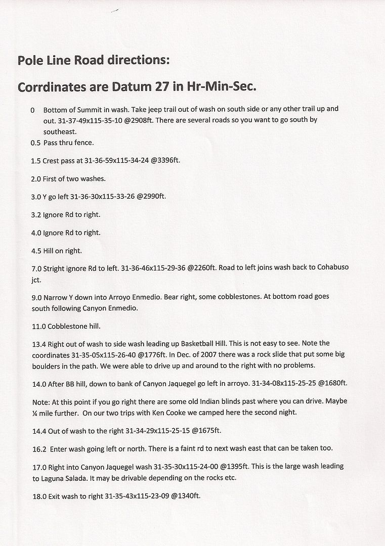
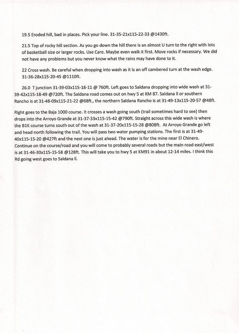
Here is a summary with coorinates in Hr-Min-Sec.
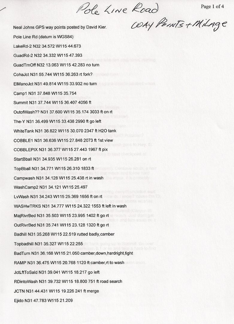
Here is what Neal Johns put together and was posted by David K.
Note the coorinates are WGS84.


|
|
|
TMW
Select Nomad
Posts: 10659
Registered: 9-1-2003
Location: Bakersfield, CA
Member Is Offline
|
|
Paul, I found this
http://forums.bajanomad.com/viewthread.php?tid=66481&pag...
russchung might supply a GPS download. U2U him.
|
|
|
Ken Cooke
Elite Nomad
Posts: 8971
Registered: 2-9-2004
Location: Riverside, CA
Member Is Offline
Mood: Pole Line Road postponed due to injury
|
|
Right on the $$
These are the waypoints for the trail. In March, we made a wrong turn that Russ noted on his GPS - we traveled a few miles east where we weren't
supposed to. Regardless, these are the GPS Waypoints that show the correct locations along the trail.
|
|
|
Mexitron
Ultra Nomad
Posts: 3397
Registered: 9-21-2003
Location: Fort Worth, Texas
Member Is Offline
Mood: Happy!
|
|
TW---the hill you call "rocky hill" is what we called "Bowling Ball Hill"...one of our team got out of her car to check out the u-turn and she slid
under the truck! You don't so much drive down that hill, you slide down it
|
|
|
Ken Cooke
Elite Nomad
Posts: 8971
Registered: 2-9-2004
Location: Riverside, CA
Member Is Offline
Mood: Pole Line Road postponed due to injury
|
|
To ascend the, "Bad Hill" would require locking differentials and at minimum 33" tires with good sidewalls.
|
|
|
PaulW
Ultra Nomad
Posts: 3113
Registered: 5-21-2013
Member Is Offline
|
|
Thanks,
I hope Russ will send me more info
PaulW
==========
| Quote: | Originally posted by Ken Cooke
| Quote: | Originally posted by TW
Paul, I found this
---snip... Got it --- PW
russchung might supply a GPS download. U2U him. |
These are the waypoints for the trail. In March, we made a wrong turn that Russ noted on his GPS - we traveled a few miles east where we weren't
supposed to. Regardless, these are the GPS Waypoints that show the correct locations along the trail.
|
|
|
|
PaulW
Ultra Nomad
Posts: 3113
Registered: 5-21-2013
Member Is Offline
|
|
Arroyos/Washes near San Felipe
My typing and organization skills are lacking. I guess Newbe issues on my formatting
When I post my write up it come out way to hard to read. So I will redo it to make it legible. I am off to the San Juans for some serious trails and
will be back on Monday.
PaulW
|
|
|
David K
Honored Nomad
Posts: 65562
Registered: 8-30-2002
Location: San Diego County
Member Is Offline
Mood: Have Baja Fever
|
|
| Quote: | Originally posted by PaulW
My typing and organization skills are lacking. I guess Newbe issues on my formatting
When I post my write up it come out way to hard to read. So I will redo it to make it legible. I am off to the San Juans for some serious trails and
will be back on Monday.
PaulW |
Great, looking forward to it!
|
|
|
PaulW
Ultra Nomad
Posts: 3113
Registered: 5-21-2013
Member Is Offline
|
|
Arroyo/Washes near San Felipe
Its all here and is hard to read, Never did figure out why Word copy paste results in blank lines and improper indents. Oh well Read on. I guess you
all will have to edit the result.
Paul
===========
Near San Felipe --- Arroyo/Wash Reference for explorers, July 2013
Arroyo/Wash List for San Felipe area. East of the mountains. I started exploring over 10 years ago and have slowly compiled GPS tracks for many of the
arroyos.
This write up describes what I know about each one.
What you read below is current as of when I drove the tracks
My starting place for my exploration was discussions with Bruce Barber, Lou Wells.
Many of the trips listed were located and identified using Google earth, all were subsequently driven.
**See the notes at the bottom of the list.
Starting North Notes/Comments
La Ventana Name means window. Location is N31.42912, W115.085014 about 5 miles west of Hwy5Access is Hwy5 K106.4. N31.73108W115.06422 ##
Leads W to many mine wells south of Saldana. The well place is properly named by INEGI as Tres Pozos
These wells are sometimes called Arroyo Grande wells and the count is now 4. N 31.69933W115.25297
Arroyo Grande Leads S from La Ventana road at the mine wells N 3.699613W115.25253 and heads S toward Mx3.Access at Hwy3 K152.7 is a locked
gate.N31.30171W115.42674 ## Huge vertical walls, great drive. Dead end at N31.45144W115.44256
Heavy undergrowth and trees block travel in vehicles.
"Race track (West)" Leaves Arroyo Grande N3162347W11525793 track and leads E to another wash route south to Borrego. ##
"Race track (east)" Leads S from La Ventena road N31.62176W115.23619 east of the wells and heads S to Borrego. Parallels Arroyo Grande and combines
with ##another parallel race track that comes from the Arroyo Grande track.
Both tracks cross the 4 corners N31.50022W115.17271 below the military camp (ab).
Canada Jaquegel Canada Jaquegel currently shown on the modern maps. It is alsoknown as "The Pole line Road" and Arroyo El Tule. ##
Start at Arroyo Grande N3162347W11525793
leads to the W and heads to Valley Trinidad and maybe San Matias? I have not driven the road yet.
The 1905/1919 Nelson map is the only source found for the Tule name The Arroyo road and power line were created in 1942 to service the US radar
facilities located in San Felipe and Punta Estrella. These days the route is reported passable via difficult 4x4 trail. Some of the cobble stones from
the original road still remain.PLR details courtesy of David Kier.
El Arrajal Leads west from hwy5 K133.8 N31.49351W115.06990 and allows connection of Mex5 to Mex3. ## Route passes thru the 4 corners at
N31.50022W115.17271 just north of the old military camp (ab).
Leave the arroyo near N31.36713W115.36760?
At the summit is an abandoned air strip actually in the silt bed?From Hwy 3 K159.8 N31.30136W115.42775 drive N thru the gated fence.
"Slate mine rd" Leads N from Hwy 3 K160. Turn NE off the El Arrajal road at N31.33178W115.43393. Road ends at mine
Unnamed Wash Starts at Hwy3 K160 and heads S to the north end of L Diablo Wash continues N across the downed fence to the Slate mine.
Tres Pozos Name means 3 wells. INEGI and Almanac are wrong. Tres Pozos is actually north at the mine wells. Access via the race road Hwy3 K179.3
N31.36643W115.18737. ##
Wash leads NW at Borrego at Hwy3 K181.1 N31.37789W115.17561 Wash crosses the race track N31338248W115.18757& ends in the arroyo to the west.
This arroyo is full of impassable large boulders at the point where the canyon narrows
" 3 Poles wash" Official INEGI name is Borrego, means Lamb. Generally parallels Hwy 3.
Heavily traveled by racers. Deep sand and multiple paths. Very wide. Access at 3 Poles is Hwy5 K142 N31.42501W115.04530 , But most common access is
K149.5 N31.35233W115.01612 then head N following one of the race tracks
Las Cuevitas Some locals call it "Calamity". Access is Hwy5 K149.5 N31.35233W115.01612 and leads west via gravel pit. Name means little caves. A
common duplication of names.
Leads west to Villa del Sol road (the graded road that leads to L. Diablo).
"rock crawl exit" Also known as "Smugglers route"?
Leads NW from Cuevitas at N31.29036W115.17003 to hwy3 @K174 N31.31482W115.21924
"Gypsum mine" Also called "Mica Mine". No mica, but lots of selenite gypsum crystals. Leads NW from Cuevitas N31.34654W115.08318 to the mine.
"unnamed" Arroyo leading NW from Cuevitas approx N31.35132W115.07721. Several failures to reach Hwy3. Unverified needs exploration.
"Lunch" Unnamed wash leads E from Cuevitas N31.28032W115.16275 The popular Sea of Cortez overlook lunch place. N31.28478W115.10678
"Mini Summit" Alternate names are "Telegraph Pass" & "Power line pass". ## Summit is N31.17794W115.14175. Major drop-off is at
N31.17558W115.13389 From 2 poles, Hwy5 K166/7 N31.22260W114.94805, follow race track SW or W to power line NW - summit - to Villa del Sol Rd. ##.
Since hurricane Nora - Impassable for normal rigs.
In 2011 3 Jeeps made the crossing with extensive use of winches (E to W), Several hardy moto guys have made the crossing in the last few years (W to
E). Summit is reachable from the west by following the metal powerline from Villa del Sol road. Good drive.
Las Almejas Name means clams. Wholly within ElDorado ranch, Leads W from the N/S power lineApprox at N31.13002W115.91034 Wash is internal to
ElDorado and leads west to the security fence/trench. Not proper to drive, but we have walked it many times. It's very wide, North of subdivisions
RDS/PVN/LMN/LVN. The east end is used by the buggy rental concession.
"Saltito Rd" Official INEGI name is Canon las Cuevitas. (a name duplication) Also "Zoo Rd" & "Morelia Rd". Starts at the PMEX/OXXO and passes
thru the Eldorado security entrance. Graded road used for west valley access. Starts at the ElDorado formal entrance & PMEX & the Eldorado
resident entrance at K178.5 N31.11715W114.90084 ## Public access is a new graded road called Morelia Rd starts at K181.2 N31.09822W114.89210 at
the storage place. ## Roads join near the powerline at N31.07531W114.96279
"Power line" Access from Saltito leads N & S from Saltito Rd. Used for the race track. Crossing is at N31.07510W114.96364 ##
"unnamed" Wash access from Saltito N N31.07162W114.97440 to 4 corners at N31.11539W114.03022 @ power line ## from the Hippy camp/dump road.
N31.07162W115.97440
"Dump road" Access from Saltito leads S N31.07162W115.97440 from hippy Camp to the dump then to the arches. ##
"Rams Head" Access from Saltito leads S at N31.06046W115.02131 to "Rams Head" then west to Morelia road. ## Choke point is
N31.01974W115.01864
"Highlands" Not really wash/arroyo, but just a land mark of abandoned community. Leaves Saltito north at N31.04990W115.04965 ## Leads to
interesting places like Diatoms, chalk mine then on to 4 corners at the powerline via the Connector Diagonal.
"Connector" Diagonal Leads N form Saltito at N31.05109W115.04676. The old road to 4 corners at the powerline then to Hwy 5. ##
Amarillas Name means yellow.
Some locals call it "the arroyo/wash leading to Hidden Valley" or "Lost Valley" (dead end). Begin at N30.90397W114.87803 Drive WNW ##
"Cross Over" Access leads south from Amarillas to Chanate. Also called The "Connector" High clearance required. ## Leave Amarillas near
N30.89424W114.99520. And reach Chanate at N30.87272W115.00206
Chanate Name means blackbird. Leads to west valley past Quartz Mtn at N30.89172W115.06964. ## Old Puerticitos Rd access is
N30.88951W114.82926
"ATV Track" Access leads NW from Chanate at N30.90064W115.05071 and heads to Morelia road near N30.93972W115.11941
Huatamote Some locals incorrectly call it "Percebu". Proper arroyo has been impassable to the west valley for many years . ##
Named for a Baja bush. "Seep Willow [huatamote] (Baccharis glutinosa)"
See baccharis glutinosa seep willow Guatamote =Huatamote?
The plant is used as a traditional medicine There is another Arroyo with the same name in Baja Sur and many places in Baja use the name
Huatamote. Start Hwy5 K20.7 N30.81917W114.74232 Or start at Old Puretictos Rd at N30.82310W114.81267
Parral Leads south then west from Huatamote at N30.75939W115.01267 One of many INEGI official Parral paths. This arroyo is the only passable way to
the west valley via Huatamote. ## Name means grapevine? Many water paths are called Parral & cross each other. They primarily drain overflow
storm water from the west valley.
Percebu Starts near the coast and ends in the desert east of hwy5
"Azufre" Official INEG name is Parral. Locally known as "Crazy Horse". ## Name means Sulfur. Access from Hwy 5 N30.70173W114.71217, Access from Old
Puretictos Rd at N30.69250W114.77379 Junction with Matomi N Exit at N30.68846W114.78838
"Terry" Starts at Hwy5 K54.2 N30.53429W114.69405 & ends up in Matomi or the north exit from Matomi. ## Named after the birthday guy. No INEGI
name.
Matomi Hwy5 K60- entrance is at N30.48912W114.66613. Follow many tracks. Connects to west valley road south of valley Chico. ## Named after Rancho
Matomi/Ejido Matomi. ## Arroyo eventually leads west to Rancho Matomi. Impassable since summer floods of 2012.
Los Blancas Leads SW from Matomi to the "Canelo Preserve" & the natural arch at N30.46037W114.92511 Leave Matomi and drive SW at
N30.49486W114.83202
"North Exit" race road leads north from Matomi. Leads to Azufre. ## Leave Matomi and drive north at N30.49624W114.83558
El Canelo Many paths from Hwy5. Exploration needed. Look near K63 N30.47415W114.66129 Name means Cinnamon. Access unknown. Expect deep soft
sand.
"Unnamed" Many washes further south. New HWY blocks access to many
Notes:
* The Villa del Sol graded Rd leads S from Mx3 N31.28013W115.31701 and heads toward toward "Juan's", Chinalilito, & Santa Clara on the east side
of L Diablo. Eventually connects with Saltito Rd at Morelia Jct.
* Every year Huatamote and Matomi change drastically due to major flooding from summer storms. Often impassable.
* The use of GPS with background maps is the best way to locate the roads to the arroyos
* GPS Maps are sold by Murdocknavigation.com for Lowrance & Garmin and other suppliers specifically for Garmin GPSs.
* Topo maps are available at the INEGI office in Mexicali. Instituto Nacional de Estadistica y Gergrafia (INEGI). Reforma Av 1500 By Street G,
Mexicali BC
* Please do not try to drive these places unless you have low range 4WD and high clearance and the usual recovery equipment.
* A GPS is required to find the pertinent places in my write-up. All Coordinates shown are North American Mexico 1927 Datum
* Be careful using Google Earth because their datum is "WGS 84". An incorrect datum for your GPS will result in over 200'+ errors.
To load my coords first change you GPS to the Mexico datum enter the coords then choose your favorite datum
* Kilometers noted were create by driving Oct-Dec 2012 and published by Murdock May 2013.
* Symbol ## means the tracks are shown on the Murdock Lowrance background map.
|
|
|
PaulW
Ultra Nomad
Posts: 3113
Registered: 5-21-2013
Member Is Offline
|
|
SF Arroyos list
Here is the list of Arroyos/washes in my previous post
It will help the reader for the previous post which has everything jammed together
Good luck, PaulW
La Ventana
Arroyo Grande
"Race track (West)"
"Race track (east)"
Canada Jaquegel
El Arrajal
"Slate mine rd"
Unnamed Wash
Tres Pozos
"3 Poles wash"
Las Cuevitas
"rock crawl exit"
"Gypsum mine"
"unnamed"
"Lunch"
"Mini Summit"
Las Almejas
"Saltito Rd"
"Power line"
"unnamed"
"Dump road"
"Rams Head"
"Highlands"
"Connector"
Diagonal
Amarillas
"Cross Over"
Chanate
"ATV Track"
Huatamote
Parral
Percebu
"Azufre"
"Terry"
Matomi
Los Blancas
"North Exit"
race road
El Canelo
"Unnamed"
Notes:
|
|
|
PaulW
Ultra Nomad
Posts: 3113
Registered: 5-21-2013
Member Is Offline
|
|
SF Arroyos
One more try
|
|
|
David K
Honored Nomad
Posts: 65562
Registered: 8-30-2002
Location: San Diego County
Member Is Offline
Mood: Have Baja Fever
|
|
Bruce Barber's Maps...
http://forums.bajanomad.com/viewthread.php?tid=38751
|
|
|
PaulW
Ultra Nomad
Posts: 3113
Registered: 5-21-2013
Member Is Offline
|
|
Near San Felipe --- Arroyo/Wash Reference
One more try -- Hand formatted to fit the narrow forum page. Hope you can decipher it When copying it into Word you will still have double spaces, but
you should be able to make it legable.
PW
= = =
Near San Felipe --- Arroyo/Wash Reference for explorers, July 2013
- Arroyo/Wash List for San Felipe area. East of the mountains.
- I started exploring over 10 years ago and have slowly compiled GPS tracks for many of the arroyos.
- This write up describes what I know about each one.
- What you read below is current as of when I drove the tracks
- My starting place for my exploration was discussions with Bruce Barber, Lou Wells.
- Many of the trips listed were located and identified using Google earth, all were subsequently driven.
**See the notes at the bottom of the list.
Arroyos Starting North with Notes/Comments
La Ventana Name means window. Location is N31-42.912, W115-08.5014 about 5 miles west of Hwy5 Access is Hwy5 K106.4. N31.73108W115.06422 ##
Leads W to many mine wells south of Saldana. The well place is properly named by INEGI as Tres Pozos These wells are sometimes called Arroyo Grande
wells and the count is now 4. N 31.69933W115.25297
Arroyo Grande Leads S from La Ventana road at the mine wells N 3.699613W115.25253 and heads S toward Mx3.
Access at Hwy3 K152.7 is a locked gate . N31.30171W115.42674 ##
Huge vertical walls, great drive. Dead end at N31.45144W115.44256 Heavy undergrowth and trees block travel in vehicles.
"Race track (West)" goes to an unnamed arroyo Leaves Arroyo Grande N3162347W11525793 track and leads E to another wash route south to Borrego. ##
"Race track (east)" Another unnamed arroyo that Leads S from La Ventena road N31.62176W115.23619 east of the wells and heads S to Borrego. ##
Parallels Arroyo Grande and combines with another parallel race track that comes from the Arroyo Grande track. Both tracks cross the 4 corners
N31.50022W115.17271 below the military camp (ab).
Canada Jaquegel Canada Jaquegel currently shown on the modern maps. It is also known as "The Pole line Road" and Arroyo El Tule. ##
Start at Arroyo Grande N3162347W11525793
The arroyo leads to the W and heads to Valley Trinidad and maybe San Matias? I have not driven the road yet.
The 1905/1919 Nelson map is the only source found for the Tule name. The Arroyo road and power line were created in 1942 to service the US radar
facilities located in San Felipe and Punta Estrella. These days the route is reported passable via difficult 4x4 trail. Some of the cobble stones from
the original road still remain. PLR details courtesy of David Kier.
El Arrajal Leads west from hwy5 K133.8 N31.49351W115.06990 and allows connection of Mex5 to Mex3. ##
Route passes thru the 4 corners at N31.50022W115.17271 just north of the old military camp (ab). Leave the arroyo and head S near
N31.36713W115.36760? At the summit is an abandoned air strip actually in the silt bed?
From Hwy 3 K159.8 N31.30136W115.42775 drive N thru the gated fence.
"Slate mine rd" Leads N from Hwy 3 K160. Turn NE off the El Arrajal road at N31.33178W115.43393. Road ends at mine.
Unnamed Wash Starts at Hwy3 K160 and heads S to the north end of L Diablo. Wash continues N across the downed fence to the Slate mine area.
Tres Pozos Name means 3 wells. INEGI and Almanac are wrong. Tres Pozos is actually north at the mine wells. Access via the race road Hwy3 K179.3
N31.36643W115.18737. ##
Wash leads NW at Borrego at Hwy3 K181.1 N31.37789W115.17561 Wash crosses the race track N31338248W115.18757 & ends in the arroyo to the
west.
This arroyo is full of impassable large boulders at the point where the canyon narrows
" 3 Poles wash" Official INEGI name is Borrego, means Lamb. Generally parallels Hwy 3. Heavily traveled by racers. Deep sand and multiple paths. Very
wide. Access at 3 Poles is Hwy5 K142 N31.42501W115.04530. But most common access is K149.5 N31.35233W115.01612 then head N following one of the race
tracks.
Las Cuevitas Some locals call it "Calamity". Access is Hwy5 K149.5 N31.35233W115.01612 and leads west via gravel pit.
Name means little caves. A common duplication of names.
Leads west to Villa del Sol road (the graded road that leads to L. Diablo).
"rock crawl exit" Also known as "Smugglers route"?
Leads NW from Cuevitas at N31.29036W115.17003 to hwy3 at K174 N31.31482W115.21924
"Gypsum mine" Also called "Mica Mine". No mica, but lots of selenite gypsum crystals. Leads NW from Cuevitas N31.34654W115.08318 to the mine.
"unnamed" Arroyo leading NW from Cuevitas approx N31.35132W115.07721. Several failures to reach Hwy3. Unverified needs exploration.
"Lunch" Unnamed wash leads E from Cuevitas N31.28032W115.16275 The popular Sea of Cortez overlook lunch place. N31.28478W115.10678. All arroyos from
the main wash are short and dead ends.
"Mini Summit" Alternate names are "Telegraph Pass" & "Power line pass". ##
Summit is N31.17794W115.14175.
Major drop-off is at N31.17558W115.13389
From 2 poles, Hwy5 K166/7 N31.22260W114.94805, follow race track SW or W to power line NW - summit - to Villa del Sol Rd. ##.
Since hurricane Nora - Impassable for normal rigs. In 2011 3 Jeeps made the crossing with extensive use of winches (E to W). Several hardy moto guys
have made the crossing in the last few years (W to E). Summit is reachable from the west by following the metal powerline from Villa del Sol road.
Good drive.
Las Almejas Name means clams. Wholly within ElDorado ranch, Leads W from the N/S power line Approx at N31.13002W115.91034 Wash is internal to
ElDorado and leads west to the security fence/trench. Not proper to drive, but we have walked it many times. It's very wide, North of subdivisions
RDS/PVN/LMN/LVN.
The east end is used by the buggy rental concession.
"Saltito Rd" Official INEGI name is Canon las Cuevitas. (a name duplication) Also "Zoo Rd" & "Morelia Rd". Starts at the PMEX/OXXO and passes
thru the Eldorado security entrance. Graded road used for west valley access.
Starts at the ElDorado formal entrance & PMEX & the ElDorado resident entrance at K178.5 N31.11715W114.90084 ##
Public access is a new graded road called Morelia Rd starts at K181.2 N31.09822W114.89210 at the storage place. ##
Roads join near the powerline at N31.07531W114.96279
"Power line" Access from Saltito leads N & S from Saltito Rd. Used for the race track. Crossing is at N31.07510W114.96364 ##
"unnamed" Wash access from Saltito N at N31.07162W114.97440 to 4 corners at N31.11539W114.03022 at the power line ##
And from the Hippy camp/dump road. N31.07162W115.97440
"Dump road" Access from Saltito leads S N31.07162W115.97440 from hippy Camp to the dump then to the arches. ##
"Rams Head" Access from Saltito leads S at N31.06046W115.02131 to "Rams Head" then west to Morelia road. ##
Choke point is N31.01974W115.01864
"Highlands" Not really a wash/arroyo, but just a land mark of abandoned community. Leaves Saltito north at N31.04990W115.04965 ##
Leads to interesting places like Diatoms, chalk mine then on
to 4 corners at the powerline via the Connector Diagonal.
"Connector" Diagonal Leads N form Saltito at N31.05109W115.04676. The old road to 4 corners at the powerline then to Hwy 5. ##
Amarillas Name means yellow. Some locals call it "the arroyo/wash leading to Hidden Valley" or "Lost Valley" (dead end). Begin at
N30.90397W114.87803 Drive WNW ##
"Cross Over" Access leads south from Amarillas to Chanate. Also called The "Connector" High clearance required. ##
Leave Amarillas near N30.89424W114.99520. And reach Chanate at N30.87272W115.00206
Chanate Name means blackbird. Leads to west valley past
Quartz Mtn at N30.89172W115.06964. ##
Old Puerticitos Rd access is N30.88951W114.82926
"ATV Track" Access leads NW from Chanate at N30.90064W115.05071 and heads to Morelia road near N30.93972W115.11941
Huatamote Some locals incorrectly call it "Percebu". Proper arroyo has been impassable to the west valley for many years . ##
Named for a Baja bush. "Seep Willow [huatamote] (Baccharis glutinosa)"
See baccharis glutinosa seep willow Guatamote =Huatamote? The plant is used as a traditional medicine
There is another Arroyo with the same name in Baja Sur and many places in Baja use the name Huatamote.
Start Hwy5 K20.7 N30.81917W114.74232
Or start at Old Puretictos Rd at N30.82310W114.81267
Parral Leads south then west from Huatamote at N30.75939W115.01267 one of many INEGI official Parral paths. This arroyo is the only passable way to
the west valley via Huatamote. ##
Name means grapevine? Many water paths are called Parral & cross each other. They primarily drain overflow storm water from the west valley.
Percebu Starts near the coast and ends in the desert east of hwy5
"Azufre" Official INEG name is Parral. Locally known as "Crazy Horse". ## Name means Sulfur. Access from Hwy 5 N30.70173W114.71217, Access from Old
Puretictos Rd at N30.69250W114.77379 Junction with Matomi N Exit at N30.68846W114.78838
"Terry" Starts at Hwy5 K54.2 N30.53429W114.69405 & ends up in Matomi or the north exit from Matomi. ##
Named after the birthday guy. No INEGI name.
Matomi Hwy5 K60- entrance is at N30.48912W114.66613. Follow many tracks. Connects to west valley road south of valley Chico. ##
Named after Rancho Matomi/Ejido Matomi. ##
Arroyo eventually leads west to Rancho Matomi.
Impassable since summer floods of 2012.
Los Blancas Leads SW from Matomi to the "Canelo Preserve" & the natural arch at N30.46037W114.92511
Leave Matomi and drive SW at N30.49486W114.83202 into valley Canelo.
"North Exit" race road Leads north from Matomi. Connects to Azufre. ##
Leave Matomi and drive north at N30.49624W114.83558
El Canelo Many paths from Hwy5. Exploration needed. Look near K63 N30.47415W114.66129
Name means Cinnamon. Access unknown. Expect deep soft sand.
"Unnamed" Many washes further south. New HWY blocks access to many.
Notes:
* The Villa del Sol graded Rd leads S from Mx3 N31.28013W115.31701 and heads toward toward "Juan's", Chinalilito, & Santa Clara on the east side
of L Diablo. Eventually connects with Saltito Rd at Morelia Jct.
* Every year Huatamote and Matomi change drastically due to major flooding from summer storms. Often impassable.
* The use of GPS with background maps is the best way to locate the roads to the arroyos
* GPS Maps are sold by Murdocknav.com for Lowrance & Garmin. Other suppliers can be found specifically for Garmin GPSs.
* Topo maps are available at the INEGI office in Mexicali.
Instituto Nacional de Estadistica y Gergrafia (INEGI). Reforma Av 1500 By Street G, Mexicali BC
* Please do not try to drive these places unless you have low range 4WD and high clearance and the usual recovery equipment.
* A GPS is required to find the pertinent places in my write-up. All Coordinates shown are North American Mexico 1927 Datum
* Be careful using Google Earth because their datum is "WGS 84". An incorrect datum for your GPS will result in over 200'+ errors.
To load my coords first change you GPS to the Mexico datum enter the coords then choose the datum you like.
* Kilometers noted were create by driving Oct-Dec 2012 and published by Murdock May 2013.
* Symbol ## means the tracks are shown on the Murdock Lowrance background map.
|
|
|
David K
Honored Nomad
Posts: 65562
Registered: 8-30-2002
Location: San Diego County
Member Is Offline
Mood: Have Baja Fever
|
|
Thank you!!!
|
|
|
TMW
Select Nomad
Posts: 10659
Registered: 9-1-2003
Location: Bakersfield, CA
Member Is Offline
|
|
Is Matomi still closed due to the rocks?
|
|
|
PaulW
Ultra Nomad
Posts: 3113
Registered: 5-21-2013
Member Is Offline
|
|
| Quote: | Originally posted by TW
Is Matomi still closed due to the rocks? |
=========
As of last April-blocked. I have pics on my facebook. Rocks are huge and where we used to go between the wall and that very big rock is washed out.
Apparently the deluge hit the canyon wall at the narrows and brought down plenty of big stuff. Winches and workers are required to open it up. Never
fear the next big storm will fill in the holes and make it drivable. Not many locals drive down there in summer. I will drive in the fall and give a
report.
PW
|
|
|
PaulW
Ultra Nomad
Posts: 3113
Registered: 5-21-2013
Member Is Offline
|
|
My pics
No success I got the images down to 40k and they are still not accepted. Look like all pics are blocked. I read all the FAQs and did not find any
tips. How about a suggestion for a free place to put them so I can post with a link?
Anybody?
PaulW
|
|
|
Ken Cooke
Elite Nomad
Posts: 8971
Registered: 2-9-2004
Location: Riverside, CA
Member Is Offline
Mood: Pole Line Road postponed due to injury
|
|
| Quote: | Originally posted by PaulW
No success I got the images down to 40k and they are still not accepted. Look like all pics are blocked. I read all the FAQs and did not find any
tips. How about a suggestion for a free place to put them so I can post with a link?
Anybody?
PaulW |
==================================
My suggestion is to create a thread with linked
images from Facebook. They display large in size
but with great definition and clarity.
|
|
|
| Pages:
1
2
3 |


