| Pages:
1
2
3 |
Cypress
Elite Nomad

Posts: 7641
Registered: 3-12-2006
Location: on the bayou
Member Is Offline
Mood: undecided
|
|
Thanks.
|
|
|
Pacifico
Super Nomad
Posts: 1299
Registered: 5-26-2008
Member Is Offline
|
|
Another great trip report TW! I didn't know that trail could handle vehicles. Love all the pics!
"Plan your life as if you are going to live forever. Live your life as if you are going to die tomorrow." - Carlos Fiesta
|
|
|
David K
Honored Nomad
Posts: 65563
Registered: 8-30-2002
Location: San Diego County
Member Is Offline
Mood: Have Baja Fever
|
|
Great report and adventure TW... Roy (The squarecircle) has wanted us to go to Los Corrales and when Fernweh reported he got his Mercedes 4x4 from Los
Corrales to La Trinidad, it made a loop trip an exciting idea. Thank you for doing that trip so I could vicariously go along!
|
|
|
tripledigitken
Ultra Nomad
Posts: 4848
Registered: 9-27-2006
Member Is Offline
|
|
TW,
Thanks for the great report. You mentioned GPS waypoints a couple of times. What map set are you using and can you recomend it?
Ken
|
|
|
TMW
Select Nomad
Posts: 10659
Registered: 9-1-2003
Location: Bakersfield, CA
Member Is Offline
|
|
Ken, I was using the waypoints provided in Kasey Smiths GPS Guidebook
http://www.bajagpsguide.com/. Also I had added several waypoints on the Google Earth track made by Fernweh and printed it out. Kasey's guide is
good except for where we lost the 4 wheel tracks. Her trail stays closer to the ocean at that point and a tighter trail too. The 4 wheel trail goes
west around the moutains.
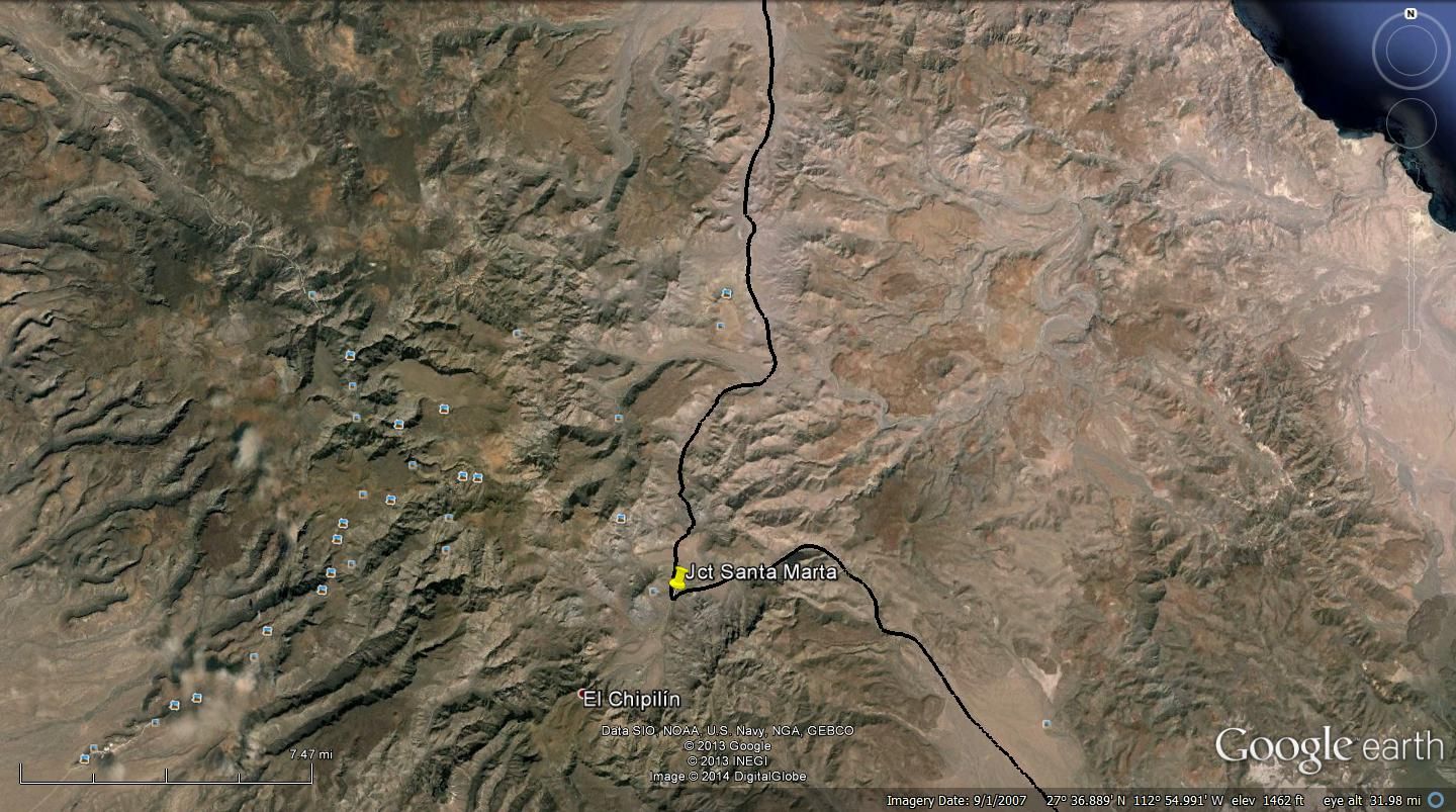
Here is the Google Earth track of the trail. Black is the 4 wheeler route and yellow is the MC route. It should be noted that the beginning from El
Barril to the second yellow is probably the only route now as rain etc may have taken out the first yellow route. It followed a wash and may or not be
passable.
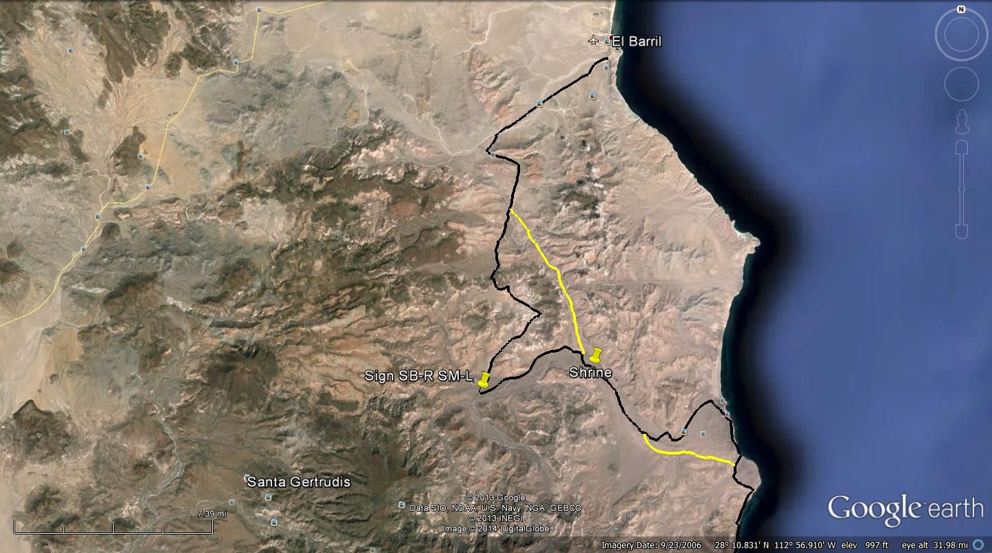
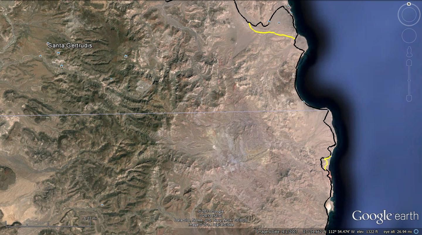

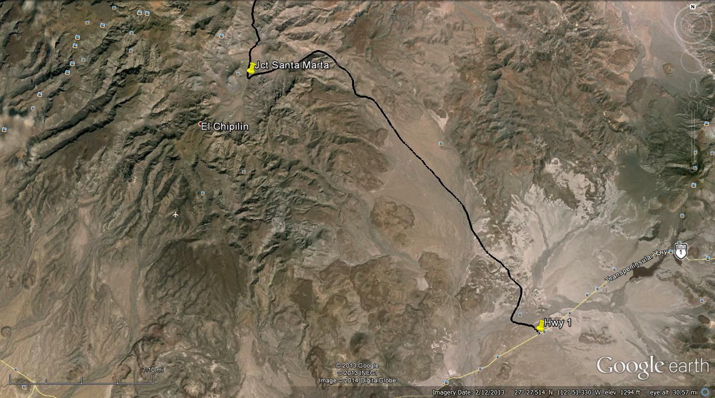
Expanded view of where the 4 wheeler and MCs use different routes and where we were lost at first. They both may use the same route now.
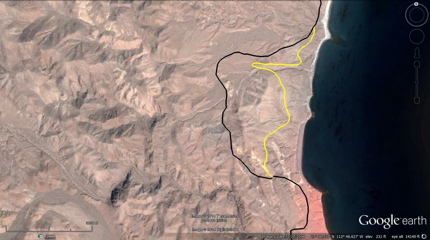
These trip notes follow the black line route.
Updated 5-8-2014
El Barril to San Ignacio:
Note: Dump at El Barril is at 28-17.515x112-53.300 and is 3 miles from R. Illusion.
Rancho Illusion gate is 0 mileage for reference.
# Miles GPS and remarks
2 0.0 28-16.138x112-55.465 Rancho Ilusion, close gate
- 1.3 Y GL
- 1.7 28-13.387x112-56.209 The Old MC trail to L
- 2.8 Road from R and road off to R
3 2.9 Open metal gate
- 5.0 28-13.201x112-56.284 Rocky downhill
- 5.2 28-12.907x112-56.390 Y GL
- 8.2 Road from R
4 8.5 28-10.750x112-56.980 Top of Mtn.
- 9.0 28-10.453x112-56.580 Either/Or
- 9.2 28-10.385x112-56.500 Road from Either/Or
5 11.7 28-09.630x112-55.325
6 14.0 28-07.767x112-57.291 Metal Gate open
7 15.0 28-07.068x112-57.535 Y GL R. Santa Barbara & R. San Miguel
8 16.9 28-07.684x112-55.943 Open Gate
- 19.1 Y GR
- 19.7 28-08.270x112-53.801 Bear Right
9 20.5 28-07.832x112-53.472 Shrine
10 23.9 28-05.622x112-51.550 Y GR San Miguel to L
- 25.4 28-05.031x112-50.370 Y GR
11 27.8 28-04.600x112-48.270 T GR
- 29.2 28-03.719x112-47.632 Rocky Beach
- 31.8 28-01.926x112-48.306 Rock Corral near beach
- 32.1 28-01.439x112-48.279 Off Beach after 100 yards on beach
12 36.6 28-00.008x112-45.947 28 Parallel R in Wash thru Gate
- 37.1 27-59.195x112-46.261 Out of wash
13 37.6 27-57.820x112-45.480 Rd Turns R
- 38.5 27-57.730x112-45.482 Open Gate at Beach
14 40.0 27-57.080x112-45.895 R in Wash then L uphill out of Wash
15 40.2 27-56.960x112-46.010 Palapa on hill follow road up to it turning west.
16 40.5 27-56.915x112-46.332 Y GR
17 41.2 27-56.816x112-46.603
18 41.7 27-56.320x112-46.510
19 42.2 27-56.132x112-46.112 Green Sulfur Hill
20 43.2 27-55.770x112-46.140
21 44.4 27-55.500x112-45.890
- 45.3 27-55.213x112-45.800 around red rock & uphill GPS is top of hill
22 45.5 27-54.46x112-45.930
23 46.7 27-53.245x112-46.129
24 48.8 27-51.360x112-46.060
25 50.7 27-49.890x112-45.300
26 56.6 27-49.528x112-48.729
27 62.8 27-49.350x112-52.280 El Gato Corral
28 68.4 27-44.482x112-53.722 Rd from R GS
29 78.2 27-37.280x112-54.690 Rd from R GS
30 84.0 27-33.430x112-56.380 Rd from R GS
31 84.6 27-32.710x112-56.470 Santa Marta Jct. GL
32 94.7 27-29.260x112-48.400 Rd from R GS
33 107.2 27-21.590x112-42.700 Hwy 1 R to San Ignacio
[Edited on 1-31-2014 by TW]
[Edited on 5-8-2014 by TW]
|
|
|
Mexitron
Ultra Nomad
Posts: 3397
Registered: 9-21-2003
Location: Fort Worth, Texas
Member Is Offline
Mood: Happy!
|
|
| Quote: | Originally posted by dtbushpilot
You're killing me TW, looks like I missed a fun trip. Great post and pictures, thanks for posting... |
Exactly! Looked like fun...
|
|
|
David K
Honored Nomad
Posts: 65563
Registered: 8-30-2002
Location: San Diego County
Member Is Offline
Mood: Have Baja Fever
|
|
The Area of TW and XR Phil's Expedition on AAA map
El Barril to Santa Marta (northeast of San Ignacio):
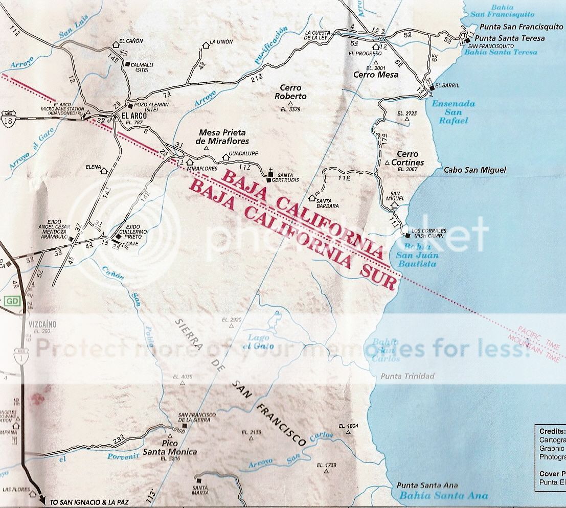
Zoom:

|
|
|
churro
Nomad
Posts: 195
Registered: 5-6-2013
Member Is Offline
|
|
Thanks for posting!!!
|
|
|
TMW
Select Nomad
Posts: 10659
Registered: 9-1-2003
Location: Bakersfield, CA
Member Is Offline
|
|
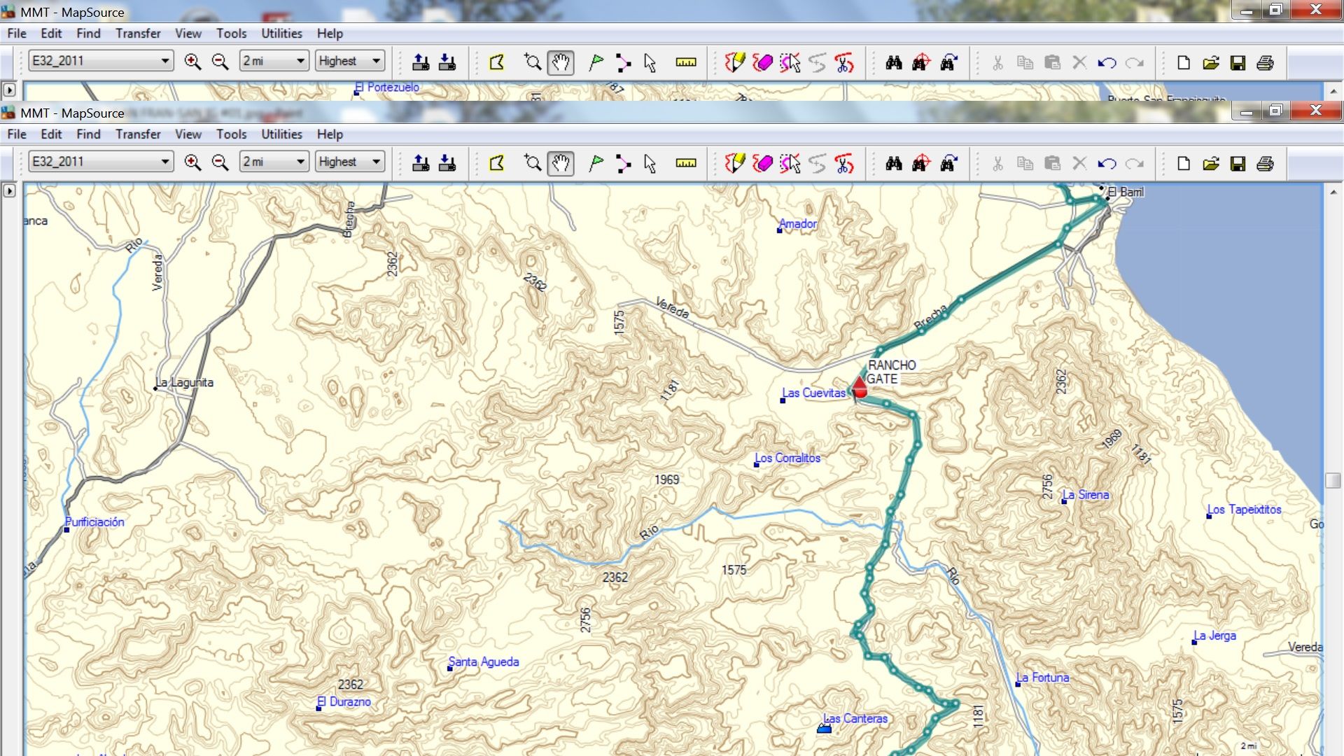
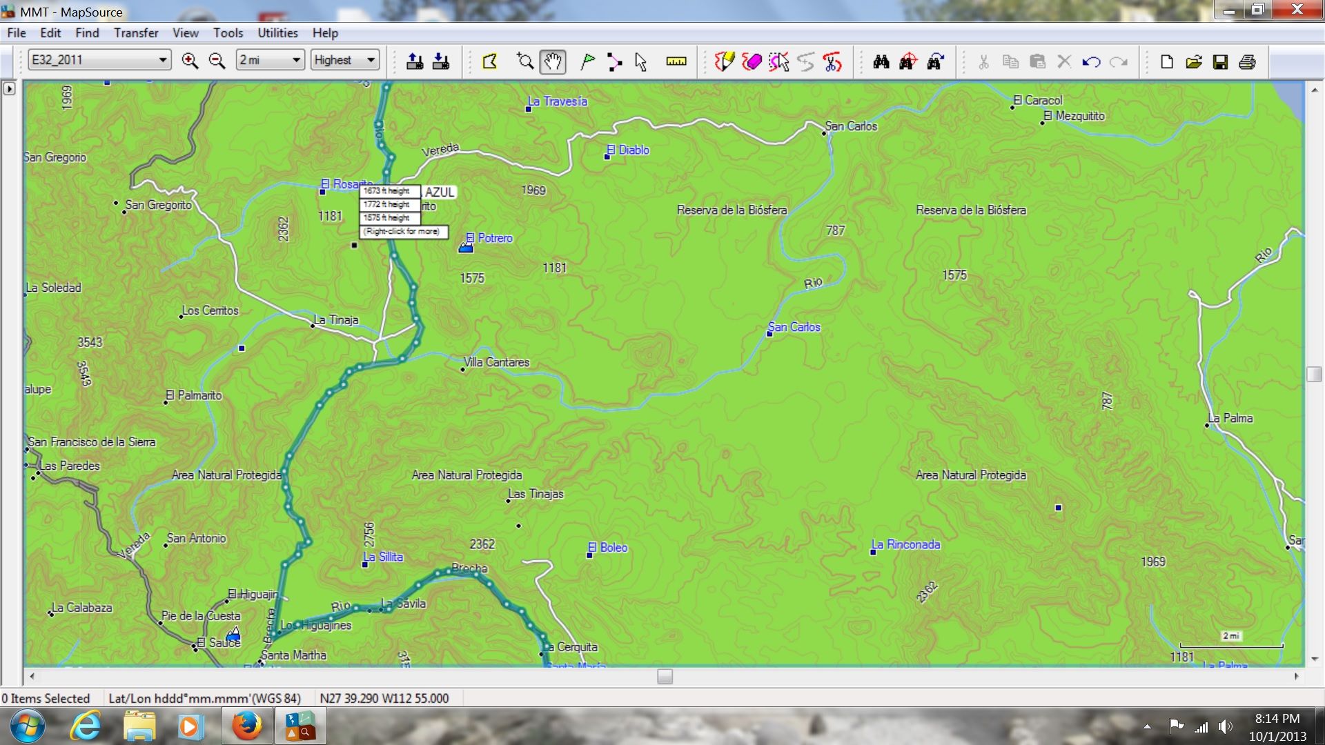
Here is another set of maps I used.


|
|
|
elgatoloco
Ultra Nomad
Posts: 4355
Registered: 11-19-2002
Location: Yes
Member Is Offline
|
|
Wow! What a nice adventure. Thanks for sharing that.
MAGA
marooons Are Governing America
|
|
|
Martyman
Super Nomad
Posts: 1904
Registered: 9-10-2004
Member Is Offline
|
|
Now I have another reason to get a 4 wheel drive vehicle. Great adventure!
|
|
|
Neal Johns
Super Nomad
Posts: 1687
Registered: 10-31-2002
Location: Lytle Creek, CA
Member Is Offline
Mood: In love!
|
|
TW,
You do pretty good for a kid!
Great trip and report.
Neal
My motto:
Never let a Dragon pass by without pulling its tail!
|
|
|
TMW
Select Nomad
Posts: 10659
Registered: 9-1-2003
Location: Bakersfield, CA
Member Is Offline
|
|
Thanks Neal, we were hoping to get you down there to show us where the dinosaur bones were.
|
|
|
David K
Honored Nomad
Posts: 65563
Registered: 8-30-2002
Location: San Diego County
Member Is Offline
Mood: Have Baja Fever
|
|
| Quote: | Originally posted by TW
Thanks Neal, we were hoping to get you down there to show us where the dinosaur bones were. |
Does Neal remember where he buried his pet? 
|
|
|
pappy
Senior Nomad
Posts: 679
Registered: 12-10-2003
Member Is Offline
|
|
great report and trip. thanks!
|
|
|
redhilltown
Super Nomad
Posts: 1130
Registered: 1-24-2009
Location: Long Beach, CA
Member Is Offline
|
|
Fantastic!!!!!!!!!!!!!!!!
|
|
|
cpg
Nomad
Posts: 262
Registered: 4-10-2006
Location: Livermore, Ca.
Member Is Offline
|
|
Great report thanks for sharing.
|
|
|
Desertbull
Senior Nomad
Posts: 558
Registered: 8-27-2003
Member Is Offline
|
|
Been doing this for quite some time in the Black Mamba ... It's not for those that can't support themselves and you have to have at least a 200 miles
fuel range. Their is no one to help you if something goes sideways and it's a long way from somewhere. It's a 2 truck adventure for sure.
Besides the obvious, you will encounter several deep sand washes and a couple hill climbs out of those washes and of course the kicker is getting
around the point in the deep shale just south of Los Corrales. You just gotta commit 100%.
Over the years the track has changed here and there, but it's basic and a good nose can find the 2 track, which is now burned in fairly solid.
We usually overnight at Oscars-Rancho Escondido and head out early to make it out to Hwy 1 south of San Ignacio before dark...we have also camped at
P. Trinidad overnight...this is a great route...you can easily make it a 3 day adventure just exploring.

DREAM IT! PLAN IT! LIVE IT!
|
|
|
Bob H
Elite Nomad
Posts: 5867
Registered: 8-19-2003
Location: San Diego
Member Is Offline
|
|
Great report and photos TW. Love the maps too!!
The SAME boiling water that softens the potato hardens the egg. It's about what you are made of NOT the circumstance.
|
|
|
fudscrud
Nomad
Posts: 113
Registered: 6-8-2010
Member Is Offline
|
|
You guys are definitely not wimps doing the No Wimps Trail. I just rode that about 2 weeks before you guys so one of those tracks was probably mine!
Did you guys have any problem getting up that super soft (sugar sand) hill? It was a little tough on the bike.
|
|
|
| Pages:
1
2
3 |