| Pages:
1
2 |
4x4abc
Ultra Nomad
    
Posts: 4454
Registered: 4-24-2009
Location: La Paz, BCS
Member Is Offline
Mood: happy - always
|
|
how do I find map keys for 1:20,000 topos?
Harald Pietschmann
|
|
|
PaulW
Ultra Nomad
    
Posts: 3113
Registered: 5-21-2013
Member Is Offline
|
|
Every thing I checked for BC has been 50k or higher. Mainland surely must have 25k?
|
|
|
4x4abc
Ultra Nomad
    
Posts: 4454
Registered: 4-24-2009
Location: La Paz, BCS
Member Is Offline
Mood: happy - always
|
|
even in 50k, the stuff is entertaining
Harald Pietschmann
|
|
|
TacoFeliz
Nomad
 
Posts: 268
Registered: 7-22-2005
Location: Here
Member Is Offline
Mood: Exploratory
|
|
Just type a large area, like "i11" into the "Clave" box and hit "Consultar". All the available maps in all scales will be listed at the foot of the
page after the page refreshes. It does take a while. The page stays grayed out until it's finished.
List will show links for PDFs, Geo PDFs, GIFs and TIFs. The Geo PDFs are layered and different features can be turned on and off when you view them in
Acrobat. Older PDFs are raster files, newer ones are vector. The vector files are infinitely scalable, the raster ones are not and the image quality
degrades the larger they are viewed.
There are only 1:20000 maps available for specific areas, not the whole territory.
|
|
|
David K
Honored Nomad
        
Posts: 65421
Registered: 8-30-2002
Location: San Diego County
Member Is Offline
Mood: Have Baja Fever
|
|
Most of the Pole Line Road Run is on Map H11B25 (Agua Caliente). The rest is on H11B26 (La Ventana) including our 'Henderson Hike' area.
|
|
|
BajaBlanca
Select Nomad
      
Posts: 13246
Registered: 10-28-2008
Location: La Bocana, BCS
Member Is Offline
|
|
Centro de Información del Instituto Nacional de Estadística ...
www.inegi.org.mx
Avenida Via Rápida Oriente 9306
Centro, Tijuana, B.C.
01 664 979 7800
Juan Ruíz de Alarcón 9306
Zona Urbana Río
Tijuana, Tijuana, B.C.
01 664 978 7903
|
|
|
PaulW
Ultra Nomad
    
Posts: 3113
Registered: 5-21-2013
Member Is Offline
|
|
Mapping exercise
I have been busy downloading the INEGI maps. I have noticed that the 1974 and 1976 maps (and probably many other old versions) that were Datum
NA1927MX have been upgraded to the new Datum ITRF92. This is good because now the topos agree with the Google Earth datum WGS84. And many GPSs used
WGS84 as the default and some older units do not even have a choice of datums and are WGS84. ITRF92 is a huge advantage and now allows picking off
coords off GE and plotting them on the topo because no conversion is required.
Looking at H11B25 which is the study topo for the Pole Line Road I find that included in the process of the datum change several errors have been
fixed. Harald will be interested that “A de Enmedia” is now called “Arroyo” and is now in blue print.
So the exercise to get the latest topo map is a worthwhile effort. Most of the printer shops here in the states have the ability to make hard copy
maps from PDF in the almost D size needed. I found the Inegi dimension is 27” so the printer scales the image to fit his stock of 24” paper. The
re-size is proportional so the width is appropriate. I hope when I get back to San Felipe the cost for printed maps is less than what I paid here in
the Denver area?
You all may be interested in my new project to overlay gps tracks on GE and topos. It will be a long winded effort that I will deal with later. One
thing for sure that effort was a big deal. The bottom line it takes so much time I will not do it again. However my new knowledge of how the images
are created was very enlightening. Very academic exercise.
Paul
|
|
|
David K
Honored Nomad
        
Posts: 65421
Registered: 8-30-2002
Location: San Diego County
Member Is Offline
Mood: Have Baja Fever
|
|
Paul, thank you for what you are doing... Your efforts will be greatly appreciated by Baja back country aficionados and four wheelers!
Perhaps your work will create the next generation Baja Almanac?
|
|
|
PaulW
Ultra Nomad
    
Posts: 3113
Registered: 5-21-2013
Member Is Offline
|
|
It is probably worthwhile to repeat that going to the INEGI office wherever is not a worthwhile thing to do if all one needs are maps. They do not
stock printed material at their office. And all their products that they sold to the public in the past in map or paper form is no longer possible. If
you want these products then you download from their web site using the instruction in this thread. Then take the PDF files to a commercial print shop
and get a real map. The result is a very good product. Of course the type of paper you specify does affect the function of the map. I was offered
glossy and standard paper. Of course paper type affects he price. I cheaped out so I will have to be careful with my new maps. Your experience will
vary.
They have heavy security to get entrance to visit a real person and there will be delays while approval is obtained.
It was interesting to visit the Mexicali office to see the various people at their computers don their thing. However the small area where I was
allowed to go is very small compared the the rest of the facility.
Paul
|
|
|
David K
Honored Nomad
        
Posts: 65421
Registered: 8-30-2002
Location: San Diego County
Member Is Offline
Mood: Have Baja Fever
|
|
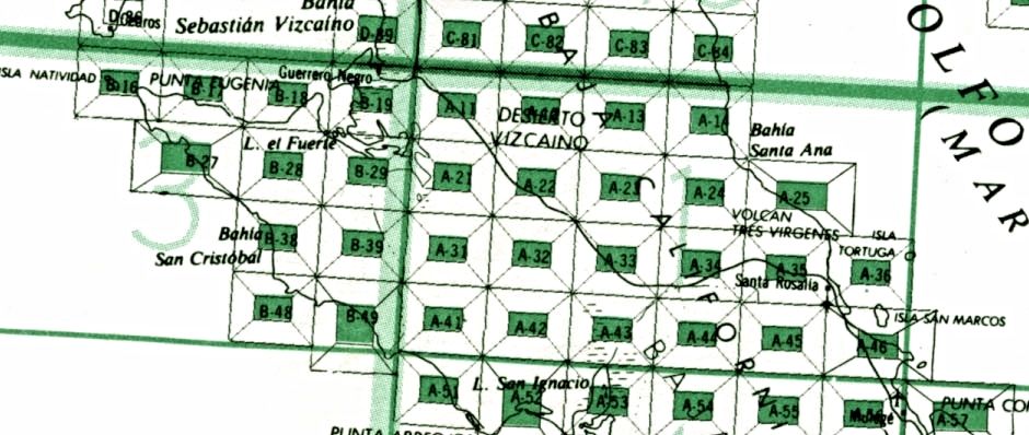
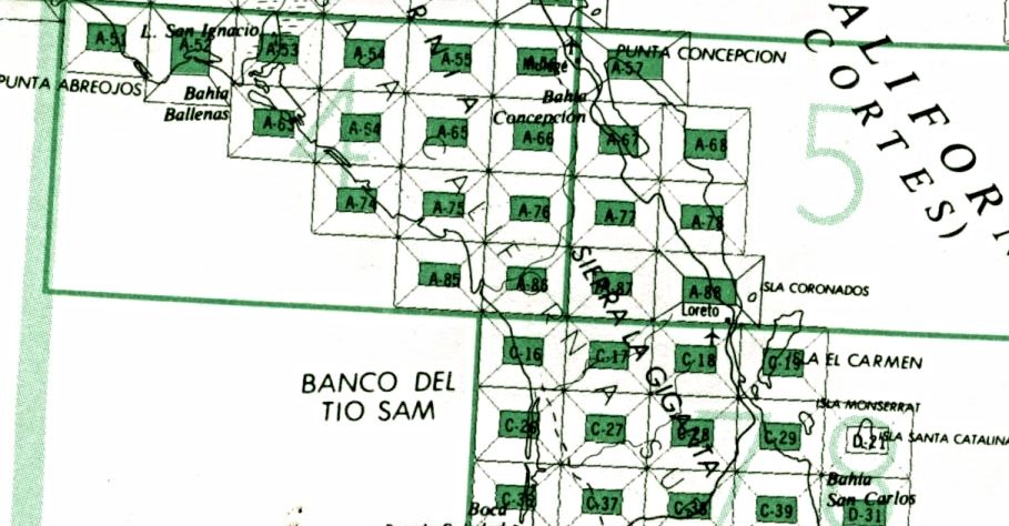
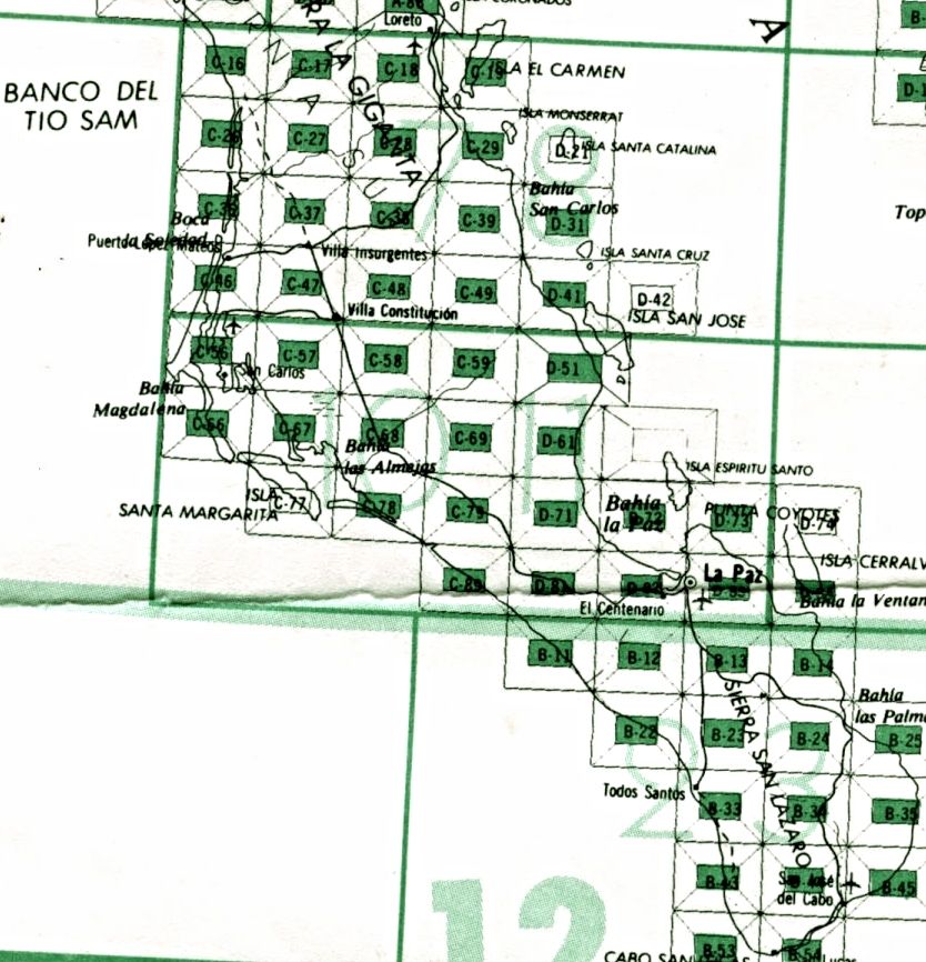
FOUND THE KEY MAP!!
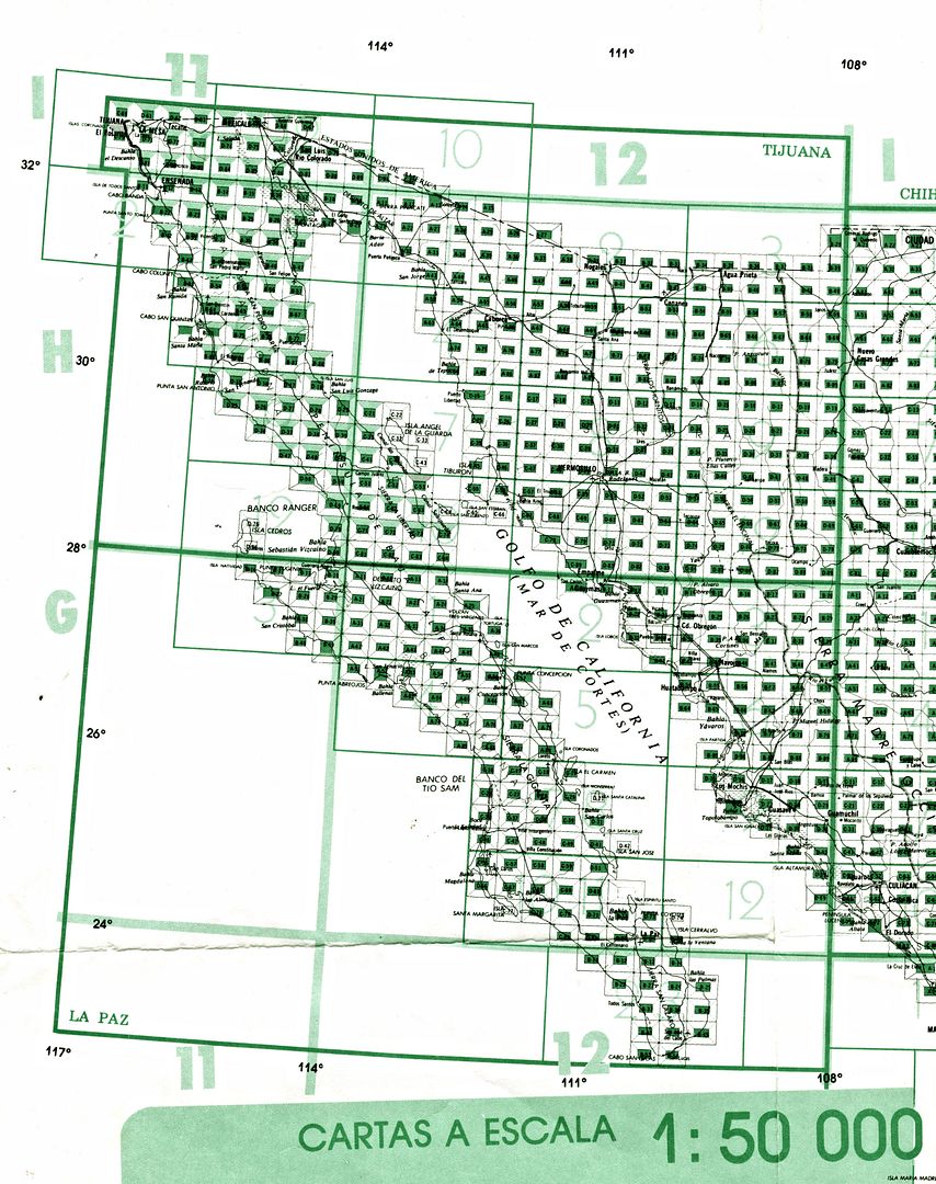
Baja California Sur
USE G11 or G12 then the single map # from key...
|
|
|
David K
Honored Nomad
        
Posts: 65421
Registered: 8-30-2002
Location: San Diego County
Member Is Offline
Mood: Have Baja Fever
|
|
BAJA CALIFORNIA (NORTE)
Quote: Originally posted by PaulW  | Now all one needs is the map Key
I cannot find it on line - so here is a image of my key with notes on the side so you can figure out what map to download

If someone finds a link for the key. Please post
|
H11 or H12 + map name
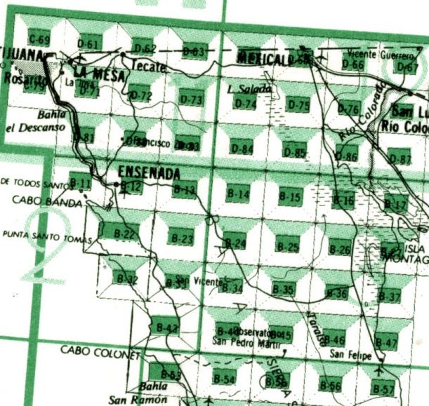
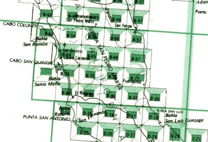
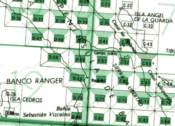
|
|
|
4x4abc
Ultra Nomad
    
Posts: 4454
Registered: 4-24-2009
Location: La Paz, BCS
Member Is Offline
Mood: happy - always
|
|
Quote: Originally posted by PaulW  | I have been busy downloading the INEGI maps. I have noticed that the 1974 and 1976 maps (and probably many other old versions) that were Datum
NA1927MX have been upgraded to the new Datum ITRF92. This is good because now the topos agree with the Google Earth datum WGS84. And many GPSs used
WGS84 as the default and some older units do not even have a choice of datums and are WGS84. ITRF92 is a huge advantage and now allows picking off
coords off GE and plotting them on the topo because no conversion is required.
Looking at H11B25 which is the study topo for the Pole Line Road I find that included in the process of the datum change several errors have been
fixed. Harald will be interested that “A de Enmedia” is now called “Arroyo” and is now in blue print.
So the exercise to get the latest topo map is a worthwhile effort. Most of the printer shops here in the states have the ability to make hard copy
maps from PDF in the almost D size needed. I found the Inegi dimension is 27” so the printer scales the image to fit his stock of 24” paper. The
re-size is proportional so the width is appropriate. I hope when I get back to San Felipe the cost for printed maps is less than what I paid here in
the Denver area?
You all may be interested in my new project to overlay gps tracks on GE and topos. It will be a long winded effort that I will deal with later. One
thing for sure that effort was a big deal. The bottom line it takes so much time I will not do it again. However my new knowledge of how the images
are created was very enlightening. Very academic exercise.
Paul
|
Paul, let me know if you need tracks - I have a few
Harald Pietschmann
|
|
|
PaulW
Ultra Nomad
    
Posts: 3113
Registered: 5-21-2013
Member Is Offline
|
|
When I got help at the Inegi office the nice lady said she would download the ones I requested onto a CD. What I wanted was a list of 11HB maps in
the San Felipe area.
Big Surprise all of them a have a title like this “San Felipe Map 8B.tif”
The maps are zoom able and sure look different that the PDF maps we have been using.
Here is a pic in the area of the 3 summits
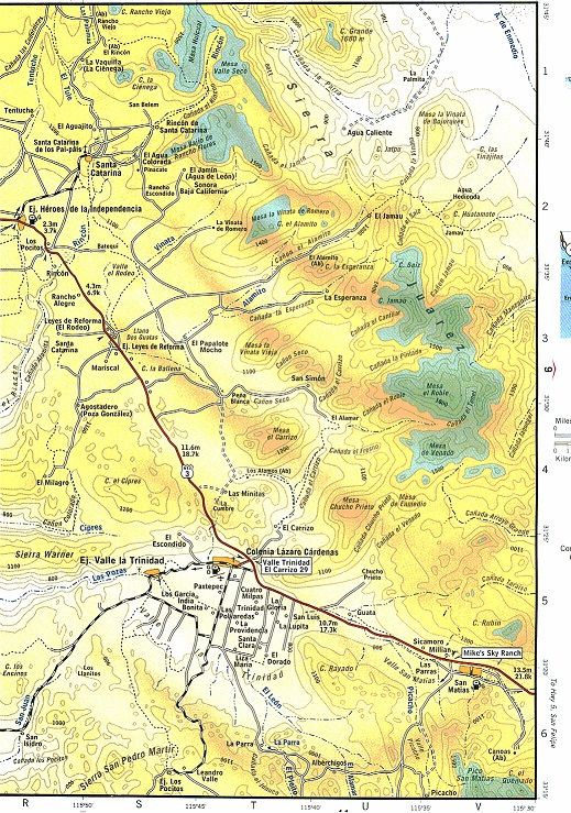
Contents of the CD
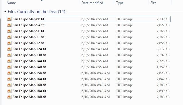
What she gave me is pieces of a colorized large scale map that ended up being random pieces of maps with different zoom levels. Spent plenty of time
taping them together and decided the pdf topos are better, just less color.
|
|
|
David K
Honored Nomad
        
Posts: 65421
Registered: 8-30-2002
Location: San Diego County
Member Is Offline
Mood: Have Baja Fever
|
|
The map above is what is in the 2003 Baja Almanac...
|
|
|
PaulW
Ultra Nomad
    
Posts: 3113
Registered: 5-21-2013
Member Is Offline
|
|
==========
Thanks,
I will save them with my other Inegi downloads. They can be zoomed for a close look. I printed them so I can figure out which one to consult and there
are no lat/long ticks.
Paul
|
|
|
PaulW
Ultra Nomad
    
Posts: 3113
Registered: 5-21-2013
Member Is Offline
|
|
I would like to have the link to the key. Can you provide it?
Thanks, Paul
|
|
|
| Pages:
1
2 |

