| Pages:
1
2
3 |
David K
Honored Nomad
        
Posts: 65436
Registered: 8-30-2002
Location: San Diego County
Member Is Offline
Mood: Have Baja Fever
|
|
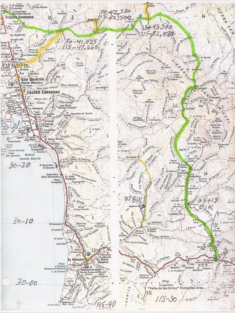
here are some maps (Baja Almanac) with this Sierra Foothill Road drawn in:
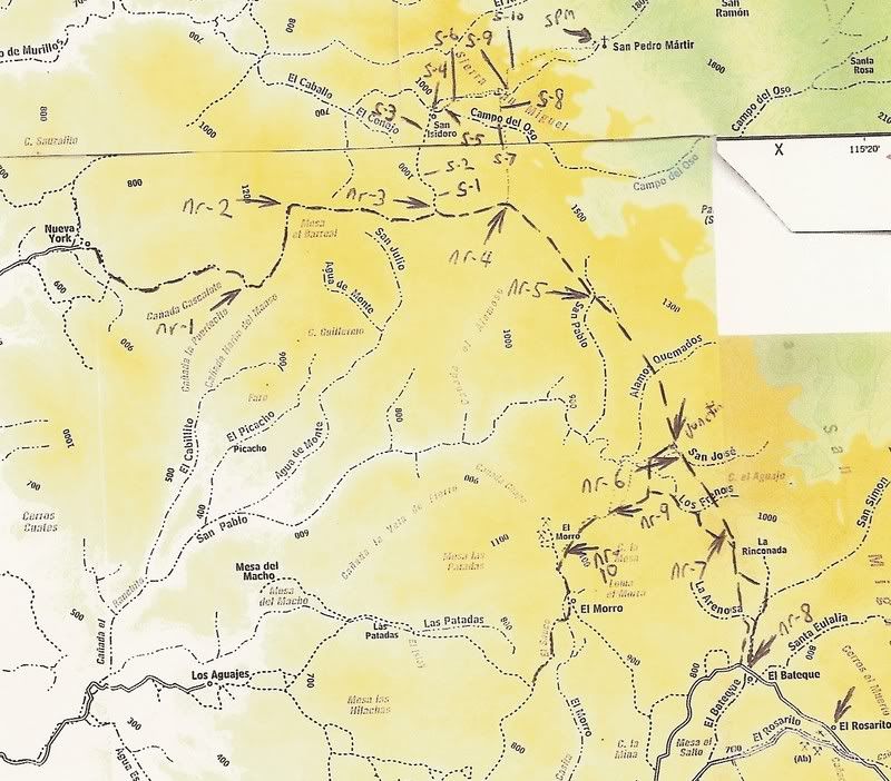
All the codes along the roads and trails above are satellite images I have saved to spot and map these roads. nr-3 is where TW headed north to San
Isidoro while The squarecircle waited. S-4 is San Isidoro.
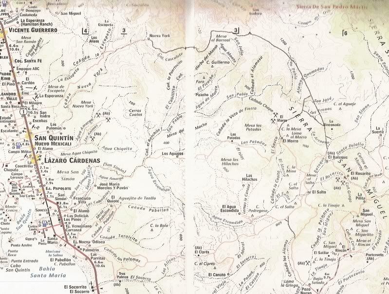
The south end of this road meets older routes to Rancho El Rosarito, Rancho Nuevo and Rancho La Suerta coming up from El Socorro (south of San Quintin
or from El Sauzalito and the Los Martires road (near El Arenoso east of El Rosario).
|
|
|
4x4abc
Ultra Nomad
    
Posts: 4454
Registered: 4-24-2009
Location: La Paz, BCS
Member Is Offline
Mood: happy - always
|
|
here is the corral
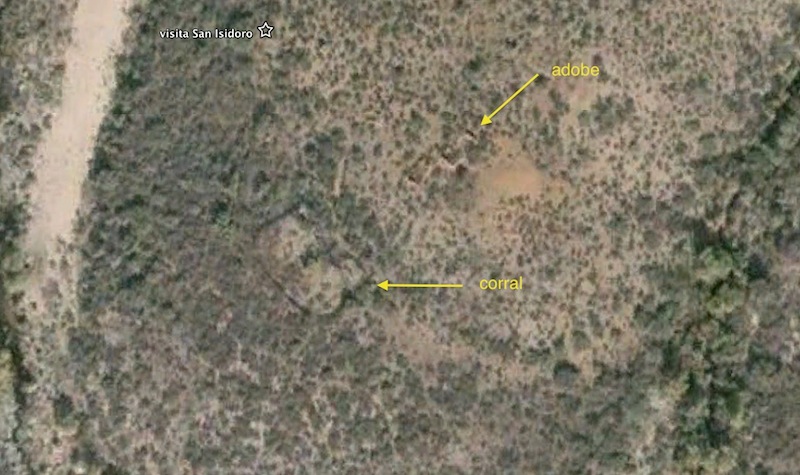
Harald Pietschmann
|
|
|
TMW
Select Nomad
      
Posts: 10659
Registered: 9-1-2003
Location: Bakersfield, CA
Member Is Offline
|
|
That may be good for another trip. If Roy had not had car problems we most likely would have spent more time back there.
|
|
|
TMW
Select Nomad
      
Posts: 10659
Registered: 9-1-2003
Location: Bakersfield, CA
Member Is Offline
|
|
Quote: Originally posted by rts551  | Quote: Originally posted by David K  | Thank you, Tom, for the report... and great photos!
Two nights he slept there waiting. Once the correct flatbed arrived, it demanded U.S. $1,500 deposit and only took him as far as a Rosarito Beach
Pemex... where he was left without any more cash!
Through the kindness of (most) Mexican people, another truck took him (he thought to the border, but instead to Playas de Tijuana... and made a
connection with a truck that had the visa to cross into the U.S.. That truck took Roy to his bank and then to his home in East County, San Diego.
Roy assumes (or hopes) that driver will pay off the previous truck, who helped Roy on the honor system.
|
Question. Why didn't he stop at an ATM in Ensenada or somewhere else along the way?
|
I don't know if it makes a difference as to using an ATM but Roy told me he only has an American Express card, or maybe he doesn't have a pin number.
|
|
|
TMW
Select Nomad
      
Posts: 10659
Registered: 9-1-2003
Location: Bakersfield, CA
Member Is Offline
|
|
Quote: Originally posted by Ateo  | | Excellent report as always Tom. Nice to see that race course section that you helped me navigate in 2013. I remember when we were looking for an
area to pit we failed initially, due to the narrow road that went on for miles. I want to get back out to this area again someday. Thanks for
posting. |
Ateo, I was thinking of you when we got back there and was wondering where your pit was. You are right it is not a wide road in many places. It also
is slow for anything short of a good pre-runner or race truck. 5 hours to go 30-35 miles coming out.
|
|
|
Baja Bucko
Nomad
 
Posts: 288
Registered: 9-23-2003
Member Is Offline
|
|
Camped at San Isidoro on the long ride-La Mula Mil in late Feb 2014. I have been in to the SSPM site 3 times but that was in the '70s before much was
burned off by fires...backpacked first time, other two on mules.....always wanted to get back up there but I do not backpack anymore-its by mule or
short distance hiking. TONS of rattlesnakes each time I made it into the SSPM mission site.. lots of them!!!
My other 4WD is a Baja Mule!
La Mula Mil Survivor 2013-2014!
1000 miles by mule from the tip to Tecate!
|
|
|
David K
Honored Nomad
        
Posts: 65436
Registered: 8-30-2002
Location: San Diego County
Member Is Offline
Mood: Have Baja Fever
|
|
Quote: Originally posted by Baja Bucko  | | Camped at San Isidoro on the long ride-La Mula Mil in late Feb 2014. I have been in to the SSPM site 3 times but that was in the '70s before much was
burned off by fires...backpacked first time, other two on mules.....always wanted to get back up there but I do not backpack anymore-its by mule or
short distance hiking. TONS of rattlesnakes each time I made it into the SSPM mission site.. lots of them!!! |
Teddi, it would be a real shame if you don't write a book! 
|
|
|
TMW
Select Nomad
      
Posts: 10659
Registered: 9-1-2003
Location: Bakersfield, CA
Member Is Offline
|
|
Talking about mules about 1 mile or 2 before the turnoff we came upon some cattle in the road. I stopped waiting for them to move when a cowboy came
riding up scattering the cows into the bushes. I told him I was going to San Isidoro and he smiles and said si. He asked for a cigarette which Roy
gave him. The horse looked mostly to be a Palomino in color but I noticed the ears were large like a mule. I mention that and he said si, mula
That's the first mule I've ever seen that was blond or goldish colored. Maybe Baja Bucko has seen them or maybe it's more common that I thought.
|
|
|
wessongroup
Platinum Nomad
       
Posts: 21152
Registered: 8-9-2009
Location: Mission Viejo
Member Is Offline
Mood: Suicide Hot line ... please hold
|
|
Thanks TW .. .for the ride along  
You do keep busy ... good for you and others
|
|
|
TMW
Select Nomad
      
Posts: 10659
Registered: 9-1-2003
Location: Bakersfield, CA
Member Is Offline
|
|
You are welcome.
It's funny I've been trying to get to Mission Santa Gertrudis for a couple of years. It seems I get all around it but never to it.
|
|
|
Baja Bucko
Nomad
 
Posts: 288
Registered: 9-23-2003
Member Is Offline
|
|
It is a shame Rancho Santa Barbara and San Miguel are now abandoned...I rode mules from the coast to R. Santa Barbara about 14 years ago and it was
such a beautiful place and the Californio family who'd lived there for generations was so proud of it. The youngest daughter had an eye on my teenage
son... Rode to and then back to San Miguel as Arturo still owned it (SM)...The young wife at Santa Barbara got breast cancer and then things went to
hell in a bread basket and I am sure the old folks are now dead (and the young wife) and the son moved on. San Miguel has such a rich history but
land ownership issues tore a family a part and money talks. So now both places that once had such old time proud hardworking Californio families
living on the land are now abandoned. I guess some would call this progress in these modern times....I call it sad.
David-I am working on it....
My other 4WD is a Baja Mule!
La Mula Mil Survivor 2013-2014!
1000 miles by mule from the tip to Tecate!
|
|
|
BajaBlanca
Select Nomad
      
Posts: 13247
Registered: 10-28-2008
Location: La Bocana, BCS
Member Is Offline
|
|
fantastic report!
|
|
|
bkbend
Senior Nomad
  
Posts: 695
Registered: 11-27-2003
Location: central OR or central baja
Member Is Offline
|
|
Sorry I'm late jumping in, my wife and I were the ones with the dog who stopped by when you were at Coco's. That is an impressive trophy and a great
gesture. Happy to hear three-fourths of the trip mostly went well. I hope to get down to Panchos next month and made note of his clothes sizes and
should be able to find something here in BdeLA.
|
|
|
bajatrailrider
Ultra Nomad
    
Posts: 2520
Registered: 1-24-2015
Location: Mexico
Member Is Offline
Mood: Happy
|
|
TMW how many hours you think about.Baja course 2013 Vicente Guerrero,to San Quintin.Also stop at mission,I know you went 4x4,we will be on bikes.Hope
to do it Mid Feb.Was road ruff,or easy going.Lots of woops,slit or no more of that.Thanks
|
|
|
TMW
Select Nomad
      
Posts: 10659
Registered: 9-1-2003
Location: Bakersfield, CA
Member Is Offline
|
|
The course for a 4 wheeler was basically good. No whoops or silt. There were places with some rain ruts and some rocky sections but not big rocks
where we had to drive around. Some fun big hills to go up and down that were not very wide in places. Some were off camber. No bad stuff just enough
to slow a 4x4 down. There were places we went 30+mph and others down to 5 mph. For a bike it would be a lot of fun, our 30 is your 50+ and our 5 would
be your 15+ is my guess. I think you will like it a lot. There were a couple of places where we drove in the water following a stream, not deep just
wet.
Our driving time was slow mainly due to Roy needing to stop because of his problems. From the bridge at Vicente Guerrero to Hwy 1 at KM103 is approx.
100 miles as per the 2013 Baja 1000 map. If you didn't stop except for maybe gas a bike could do it in 4-5 hours easy. Stop for lunch and maybe see
the mission site and your probably looking at 8 hours. It would be a good day trip.
[Edited on 1-29-2016 by TMW]
|
|
|
David K
Honored Nomad
        
Posts: 65436
Registered: 8-30-2002
Location: San Diego County
Member Is Offline
Mood: Have Baja Fever
|
|
Here's where I first reported on this road with maps and satellite images of it, back in 2009: http://forums.bajanomad.com/viewthread.php?tid=37433
|
|
|
bajatrailrider
Ultra Nomad
    
Posts: 2520
Registered: 1-24-2015
Location: Mexico
Member Is Offline
Mood: Happy
|
|
Quote: Originally posted by TMW  | The course for a 4 wheeler was basically good. No whoops or silt. There were places with some rain ruts and some rocky sections but not big rocks
where we had to drive around. Some fun big hills to go up and down that were not very wide in places. Some were off camber. No bad stuff just enough
to slow a 4x4 down. There were places we went 30+mph and others down to 5 mph. For a bike it would be a lot of fun, our 30 is your 50+ and our 5 would
be your 15+ is my guess. I think you will like it a lot. There were a couple of places where we drove in the water following a stream, not deep just
wet.
Our driving time was slow mainly due to Roy needing to stop because of his problems. From the bridge at Vicente Guerrero to Hwy 1 at KM103 is approx.
100 miles as per the 2013 Baja 1000 map. If you didn't stop except for maybe gas a bike could do it in 4-5 hours easy. Stop for lunch and maybe see
the mission site and your probably looking at 8 hours. It would be a good day trip.
[Edited on 1-29-2016 by TMW] |
Thank you
|
|
|
TMW
Select Nomad
      
Posts: 10659
Registered: 9-1-2003
Location: Bakersfield, CA
Member Is Offline
|
|
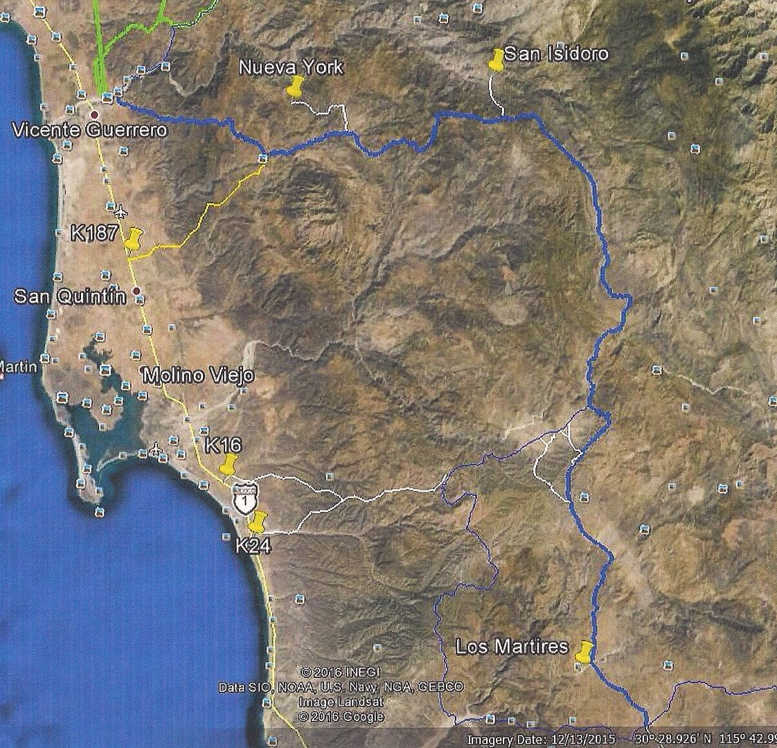
Here is a Google Earth image of the 2003 and 2007 Baja 1000 course. The heavy blue line is the 03 course and the thinner blue is the 07 course which
went further to the west on the bottom portion. For this section the 2013 Baja 1000 followed the same path as the 03 course except in reverse, south
to north.
03&07 B1K
[Edited on 2-12-2023 by BajaNomad]
|
|
|
bajatrailrider
Ultra Nomad
    
Posts: 2520
Registered: 1-24-2015
Location: Mexico
Member Is Offline
Mood: Happy
|
|
TM So your saying,you did not come out in San Quintin,you came back to HWY 1 past it.Mile marker 103 is where? Thank you Just thinking if over
100miles.To get fuel,We would carry extra.
|
|
|
TMW
Select Nomad
      
Posts: 10659
Registered: 9-1-2003
Location: Bakersfield, CA
Member Is Offline
|
|
We came out to Hwy 1 at KM187 just north of San Quintin. My GPS showed a road out to Hwy 1 from the race course, shown in yellow above, and I decided
to take it in order to get Roy to Hwy 1. If Roy had not had problems we would have driven the race course to the arroyo where the bridge is at Vicente
Guerrero.
KM103 is on Hwy 1 south of El Rosario and marked as Los Martires. There are a couple of buildings there and a bunch of heavy equipment used for
hauling large rocks. It's in the lower right corner of this map. We turned off there.
|
|
|
| Pages:
1
2
3 |

