| Pages:
1
2
3
4
..
9 |
PaulW
Ultra Nomad
    
Posts: 3113
Registered: 5-21-2013
Member Is Offline
|
|
List for the canyons
The canyon list has not been updated. When I get around to it I will post it again since it is now missing.
Now that we have the composite of all the INEGI maps and the latest stuff from Benchmark I have slowly been making progress tracing the canyons. I
will eventually come up with coordinates at each canyon entrance.
Meanwhile I have tried to convince Benchmark to use my list and I did locate the missing and incorrect canyons for Benchmark Neil. Otherwise, time
will tell if I get my latest task for cords complete.
|
|
|
David K
Honored Nomad
        
Posts: 65434
Registered: 8-30-2002
Location: San Diego County
Member Is Offline
Mood: Have Baja Fever
|
|
Quote: Originally posted by PaulW  | List for the canyons
The canyon list has not been updated. When I get around to it I will post it again since it is now missing.
Now that we have the composite of all the INEGI maps and the latest stuff from Benchmark I have slowly been making progress tracing the canyons. I
will eventually come up with coordinates at each canyon entrance.
Meanwhile I have tried to convince Benchmark to use my list and I did locate the missing and incorrect canyons for Benchmark Neil. Otherwise, time
will tell if I get my latest task for cords complete.
|
Sounds great... Neil and the crew at Benchmark are looking forward to a Second Edition with all of our submitted additions or corrections. I had lunch
with Luis (Benchmark salesman) last week on his way to Baja. Really nice people work for Benchmark!
|
|
|
PaulW
Ultra Nomad
    
Posts: 3113
Registered: 5-21-2013
Member Is Offline
|
|
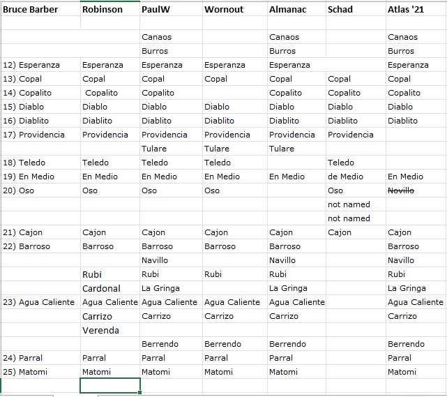
Cleaned up Canyon List
Not updated
|
|
|
4x4abc
Ultra Nomad
    
Posts: 4454
Registered: 4-24-2009
Location: La Paz, BCS
Member Is Offline
Mood: happy - always
|
|
here is what I have
Attachment: all canyons.kmz (5kB)
This file has been downloaded 294 times
Harald Pietschmann
|
|
|
David K
Honored Nomad
        
Posts: 65434
Registered: 8-30-2002
Location: San Diego County
Member Is Offline
Mood: Have Baja Fever
|
|
Paul, at your line 23 1/2 is Robinson's 'Verenda'... Given that the V and B in Spanish are very similar, it surely is an alternate spelling for
Berrendo (Verrendo/ Berendo/ Verenda)??
He did not include Verenda in his guide's canyon descriptions, however. Just his map has it located where Berrendo is and a mention in the road log
page.
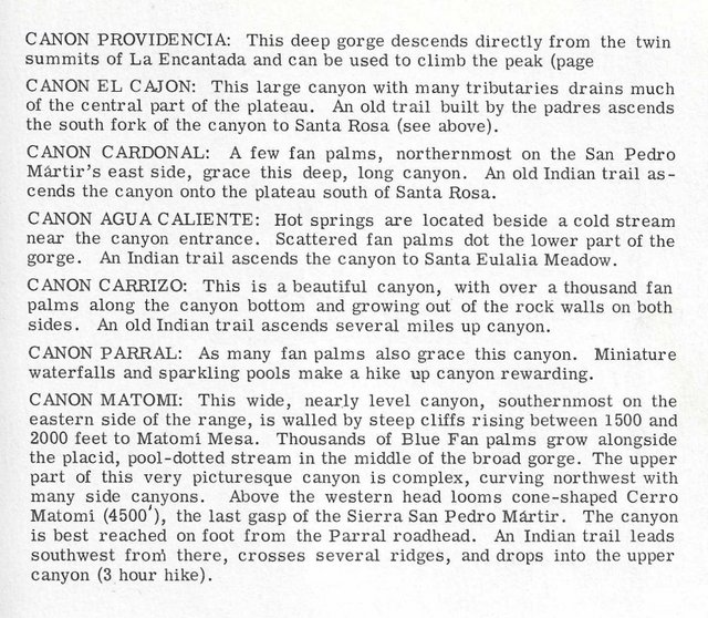
I used Cardonal for La Gringa in my article and map, based on Robinson's excellent guide to them back in 1967:
My Baja Bound article: https://www.bajabound.com/bajaadventures/bajatravel/san_feli...
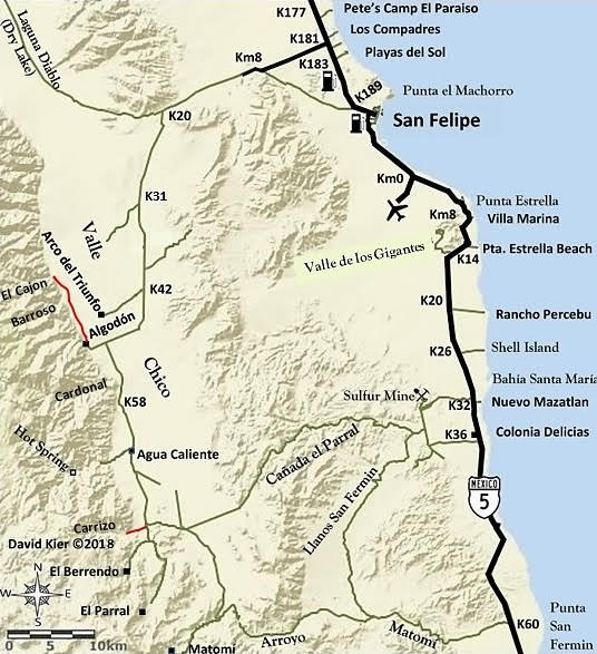
[Edited on 11-18-2021 by David K]
|
|
|
PaulW
Ultra Nomad
    
Posts: 3113
Registered: 5-21-2013
Member Is Offline
|
|
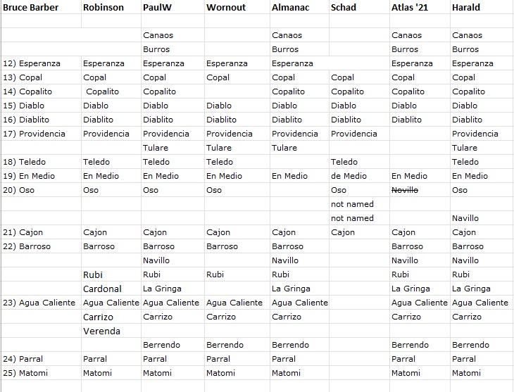
As you can see Harald and Atlas 21 both have two Novillo
I convinced myself one further north is wrong. The Almanac did not address the one to the north.
Cardonal needs further search. Harald shows it further west so the search begins there.
Good point about Verenda/Berrenda/Berrendo but the Verenda spelling is different
|
|
|
David K
Honored Nomad
        
Posts: 65434
Registered: 8-30-2002
Location: San Diego County
Member Is Offline
Mood: Have Baja Fever
|
|
A simple look at a topo map or satellite image will show you how many canyons there are.
In person visits or reading in books will let you know which ones are interesting. Flash floods have removed palm trees once found in greater numbers
in some.
|
|
|
geoffff
Senior Nomad
  
Posts: 710
Registered: 1-15-2009
Member Is Offline
|
|
Did you add INEGI 50K to your list? INEGI seems pretty confused. This is what I see:
12: (same as your list)
13: Copal & Copalito
14: Diablito
15: Providencia
16: (unnamed)
17: (unnamed)
18: (unnamed)
19: (unnamed)
20: de en Medio
21: Novillo
22: Cajón
23: (same as your list)
24: (same as your list)
25: (same as your list)
|
|
|
geoffff
Senior Nomad
  
Posts: 710
Registered: 1-15-2009
Member Is Offline
|
|
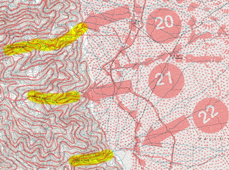
Or maybe I am confused with your Bruce Barber numbering scheme? This is what I see when I overlay Bruce's Of Sea and Sand maps on INEGI 50k. What I
see also seems to match Baja Alamanc, but not your numbering in your chart above. Am I confused somehow?
|
|
|
geoffff
Senior Nomad
  
Posts: 710
Registered: 1-15-2009
Member Is Offline
|
|
Likewise what I see when I line up Bruce's 13,14,15 on INEGI the numbers. I think I see Bruce's 13 pointing at Copal/Copalito and 14 pointing to
Diablo/Diablito, unlike your chart:

|
|
|
geoffff
Senior Nomad
  
Posts: 710
Registered: 1-15-2009
Member Is Offline
|
|
David, you know I'm that kind of nerd 
Here are the Bruce Barber numbered canyons again, but overlaid on Baja Almanac:


|
|
|
geoffff
Senior Nomad
  
Posts: 710
Registered: 1-15-2009
Member Is Offline
|
|
OK I think I see the problem. PaulW was faithfully following Bruce's text of Of Sea and Sand, but it looks like Bruce misidentifies
most of the canyons with his numbers and arrows on his maps.
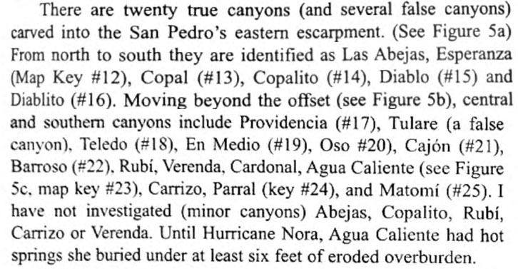
So I think we should just throw out Bruce's maps and numbering scheme  They just
confuse things! They just
confuse things!
[Edited on 11-18-2021 by geoffff]
|
|
|
David K
Honored Nomad
        
Posts: 65434
Registered: 8-30-2002
Location: San Diego County
Member Is Offline
Mood: Have Baja Fever
|
|
The 1967 John Robinson Map:
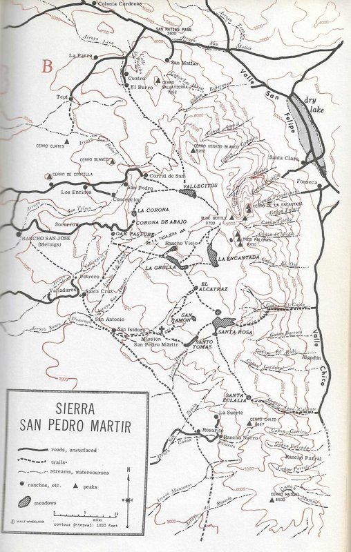
Just the canyons:

|
|
|
mtgoat666
Platinum Nomad
       
Posts: 20551
Registered: 9-16-2006
Location: San Diego
Member Is Offline
Mood: Hot n spicy
|
|
Quote: Originally posted by geoffff  | OK I think I see the problem. PaulW was faithfully following Bruce's text of Of Sea and Sand, but it looks like Bruce misidentifies
most of the canyons with his numbers and arrows on his maps.
So I think we should just throw out Bruce's maps and numbering scheme  They just
confuse things! They just
confuse things!
[Edited on 11-18-2021 by geoffff] |
For the canyons and trails, The robinson and schad maps are pretty reliable. Ignore the others.
Woke!
Hands off!
“Por el bien de todos, primero los pobres.”
“...ask not what your country can do for you – ask what you can do for your country.” “My fellow citizens of the world: ask not what America
will do for you, but what together we can do for the freedom of man.”
Pronoun: the royal we
|
|
|
4x4abc
Ultra Nomad
    
Posts: 4454
Registered: 4-24-2009
Location: La Paz, BCS
Member Is Offline
Mood: happy - always
|
|
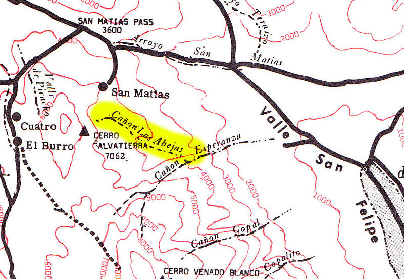
I have been searching the records for Cañon Las Abejas
no such thing in the area
Harald Pietschmann
|
|
|
PaulW
Ultra Nomad
    
Posts: 3113
Registered: 5-21-2013
Member Is Offline
|
|
GeoFFFF great images for me to follow.
Some comments – more later
Lots of INEGI issues for labels.
Bruces 13 The Copal/Copalito is an INEGI error. Disregard the lower Copalito label.
Bruces 14 For sure is Copalito
Bruces 15For sure is Diablo. Disregard the Dilabito label. Diablo has the distinctive U shape. Easy to prove when you chase the drainage way west
then South. Also ignore the Provedencia label
Bruces 16 is Dilabito is the next one south. A short drainage
See my tracing for the above canyons
Bruces 17 is Provendicia and the darn canyon is on three INEGI maps. I do not have a compete trace, But the headwaters are at Diablo S summit should
be easy to make a trace.
Geoffff said
Or maybe I am confused with your Bruce Barber numbering scheme? This is what I see when I overlay Bruce's Of Sea and Sand maps on INEGI 50k. What I
see also seems to match Baja Alamanc, but not your numbering in your chart above. Am I confused somehow?
I say
My list is just a sequence. Only Bruce’ column has numbers. Yes, I think Bruce depended a lot on the Almanac. But he like me has the very old real
INEGI maps to trace. Old maps prevail today with many of the same errors.
Geoffff said
Likewise what I see when I line up Bruce's 13,14,15 on INEGI the numbers. I think I see Bruce's 13 pointing at Copal/Copalito and 14 pointing to
Diablo/Diablito, unlike your chart:
I say
Yes, Bruce had it figured out, just like I did. Recognize the label errors and just follow the drainages. He just missed Tulare
Attachment: phpo7W4IA (326kB)
This file has been downloaded 213 times
|
|
|
geoffff
Senior Nomad
  
Posts: 710
Registered: 1-15-2009
Member Is Offline
|
|
I was thinking the same thing, but I just found one on the 1967 John Robinson map:
|
|
|
David K
Honored Nomad
        
Posts: 65434
Registered: 8-30-2002
Location: San Diego County
Member Is Offline
Mood: Have Baja Fever
|
|
You know, Geoff, the MapBox maps (when zoomed in) are pretty good topo maps that clearly show each canyon.
Maybe add the name(s) the various authors/ cartographers to each of these... It would be really visual!
I can do this at some point, but will be busy for a couple of says as we are doing the family Thanksgiving feast this weekend to avoid crowds and
chaos of next week!
|
|
|
PaulW
Ultra Nomad
    
Posts: 3113
Registered: 5-21-2013
Member Is Offline
|
|
I just traced all the drainages in that area and. . .
Nothing similar coming off labeled Esperanza on the INEGI topo.
However, there are two major drainages. The northly one is probably Esperanza as it is much larger, but the southern one has the label.
The two are connected the desert valley end.
My suspicion is the northern one is Esperanza and that leaves the southern one available for a canyon label ?? Abejas
Checkout my suspicions.
|
|
|
geoffff
Senior Nomad
  
Posts: 710
Registered: 1-15-2009
Member Is Offline
|
|
Here is my first attempt to understand and compile all PaulW's notes. How is this? What needs correcting?

|
|
|
| Pages:
1
2
3
4
..
9 |

