| Pages:
1
2
3 |
advrider
Super Nomad
   
Posts: 1916
Registered: 10-2-2015
Member Is Offline
|
|
Can you send it to me, it looks amazing. Does it come out at Catavina and take off again? Where does it end at?
|
|
|
JZ
Select Nomad
      
Posts: 13396
Registered: 10-3-2003
Member Is Offline
|
|
Quote: Originally posted by advrider  | | Can you send it to me, it looks amazing. Does it come out at Catavina and take off again? Where does it end at? |
I sent you the Hagy Mesa track. About 20 miles. The video goes from El Rosario to BoLA. They do the 22 day trail.
[Edited on 9-9-2019 by JZ]
|
|
|
advrider
Super Nomad
   
Posts: 1916
Registered: 10-2-2015
Member Is Offline
|
|
I was wondering if the second half was the 22 day trail, thanks..
|
|
|
Mulege Canuck
Nomad
 
Posts: 393
Registered: 11-27-2016
Member Is Offline
|
|
Quote: Originally posted by JZ  |
It's what MulegeAl (I think it was him) called it. This was like a week or two ago. I asked him at the time if you could get all the way to the
coast from there and he didn't really give me a straight answer.
|
I drove from Agua de Gringo to San Juanico my first time up there. I said I would never do it again. The brush is way too thick and it took me
forever to brush it out so I could get my camper down the road. The most scenic drive is the first half from Mulege.
|
|
|
JZ
Select Nomad
      
Posts: 13396
Registered: 10-3-2003
Member Is Offline
|
|
Got you. What other cool drives around the area?
|
|
|
David K
Honored Nomad
        
Posts: 65352
Registered: 8-30-2002
Location: San Diego County
Member Is Offline
Mood: Have Baja Fever
|
|
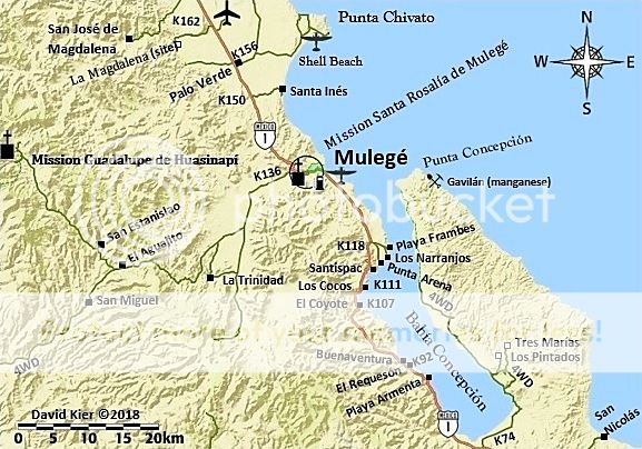
Why not go up the Concepcion peninsula? There is a nice beach at the very end on the bay side and a manganese mine (Gavilan) from the 1940s on the
gulf side. See geoffff's post on his last trip report. There is also some petroglyphs (Los Pintados) and a stream in a little canyon (Tres Marias)...
all in my Baja Extreme 2016 trip report when we tried going up to the end (a hurricane the week before washed out the road about 8 miles from the end.
|
|
|
David K
Honored Nomad
        
Posts: 65352
Registered: 8-30-2002
Location: San Diego County
Member Is Offline
Mood: Have Baja Fever
|
|
geoffff's 2019 trip report: http://forums.bajanomad.com/viewthread.php?tid=92615
|
|
|
4x4abc
Ultra Nomad
    
Posts: 4443
Registered: 4-24-2009
Location: La Paz, BCS
Member Is Offline
Mood: happy - always
|
|
whole network of roads to explore out at Rancho San Lino
will find the tracks later
Attachment: Rancho San Lino.kmz (744B)
This file has been downloaded 255 times
Attachment: Camp.kmz (689B)
This file has been downloaded 274 times
Harald Pietschmann
|
|
|
4x4abc
Ultra Nomad
    
Posts: 4443
Registered: 4-24-2009
Location: La Paz, BCS
Member Is Offline
Mood: happy - always
|
|
one of the least traveled is the 1930's road Mulege - Loreto
driven most of it with 4x4 - MC or mountain bike would be best
Attachment: old Baja road 4x4 1930's.kmz (2kB)
This file has been downloaded 242 times
Attachment: 4x4 good one old Baja road 1930's (1941 AAA).kmz (4kB)
This file has been downloaded 282 times
Attachment: Old Baja Road 4x4 1930.kmz (1kB)
This file has been downloaded 242 times
Harald Pietschmann
|
|
|
JZ
Select Nomad
      
Posts: 13396
Registered: 10-3-2003
Member Is Offline
|
|
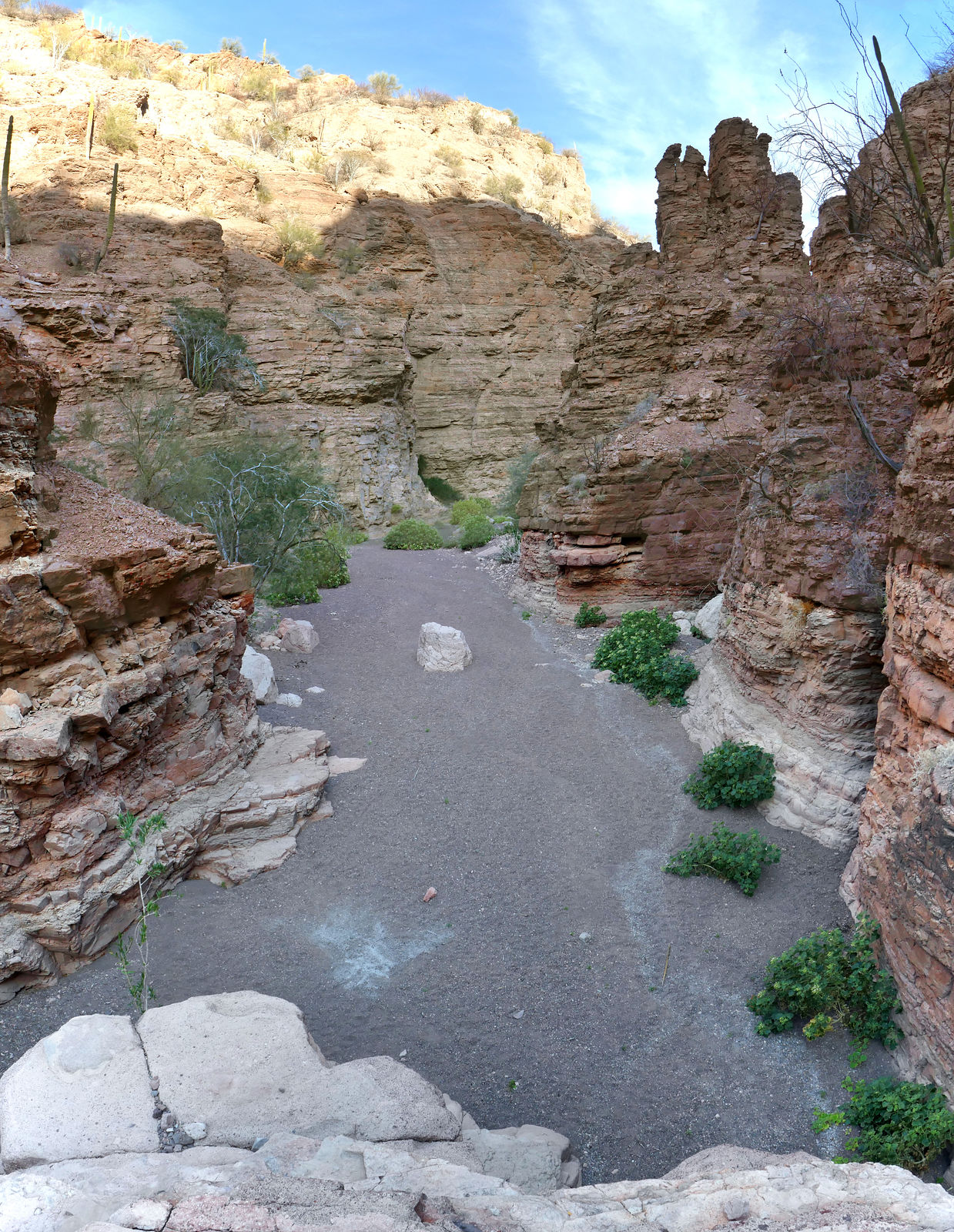
Thanks. Cool canyon out there.
|
|
|
Nikno
Junior Nomad

Posts: 90
Registered: 7-12-2019
Member Is Offline
|
|
JZ:
On the San Nicolas thread you posted a map that has "Caves" marked on it. Those caves appear to be within 1 mile of Ensenada de Mangle which is where
the abandoned villas are on that track I posted. There are some roads that go in the direction of the caves but none of them appear to go through. I'm
curious what kind of caves are there and are they worth checking out? Also, do you have exact coordinates?
My thought was next time I'm in the area to either get as close as possible and hike over or launch a kayak from the beach and check it out.
Harald:
Thanks for posting the old 1930's road. I will definitely check that one out next time I'm there. As I recall, the road continued south and went by
Comondu Viejo. I believe David K. posted about doing that road 50 years ago. Is that correct, David? Does anyone have a pic of the 1930 map they can
post?
|
|
|
David K
Honored Nomad
        
Posts: 65352
Registered: 8-30-2002
Location: San Diego County
Member Is Offline
Mood: Have Baja Fever
|
|
Quote: Originally posted by Nikno  | JZ:
On the San Nicolas thread you posted a map that has "Caves" marked on it. Those caves appear to be within 1 mile of Ensenada de Mangle which is where
the abandoned villas are on that track I posted. There are some roads that go in the direction of the caves but none of them appear to go through. I'm
curious what kind of caves are there and are they worth checking out? Also, do you have exact coordinates?
My thought was next time I'm in the area to either get as close as possible and hike over or launch a kayak from the beach and check it out.
Harald:
Thanks for posting the old 1930's road. I will definitely check that one out next time I'm there. As I recall, the road continued south and went by
Comondu Viejo. I believe David K. posted about doing that road 50 years ago. Is that correct, David? Does anyone have a pic of the 1930 map they can
post? |
The main road to La Paz (to 1971) passed by Comondú Viejo as well as San José and San Miguel Comondú. Loreto was on an almost dead-end road (but
you could go on south via San Javier). The new highway being built north from La Paz went from Insurgentes east to Ligüí and then north to Loreto
and on to Mulegé.
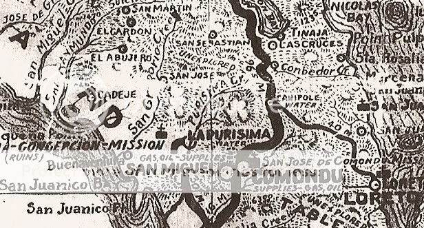
Here is the 1930 map of that area (note, it is not accurate in many places):
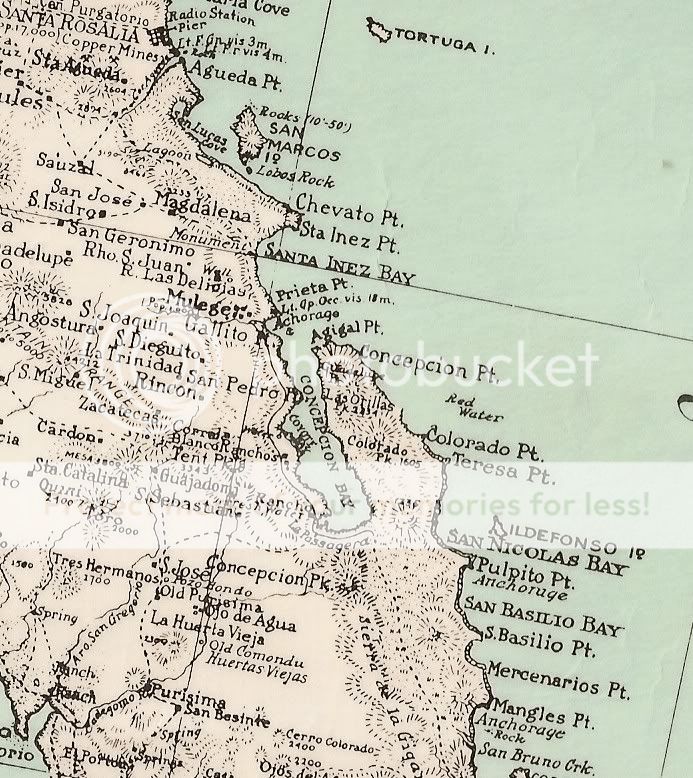
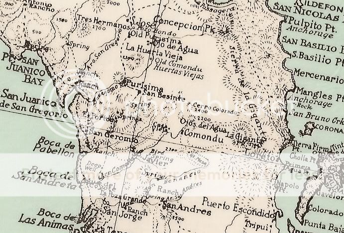
If you search the Baja Historic Interests & Maps forum here on Nomad, you can see more of this and other old maps. You are also welcome to see
them on my Photobucket maps albums. Here is the 1930 album: https://s213.photobucket.com/user/DavidKier/library/Maps/193...
|
|
|
David K
Honored Nomad
        
Posts: 65352
Registered: 8-30-2002
Location: San Diego County
Member Is Offline
Mood: Have Baja Fever
|
|
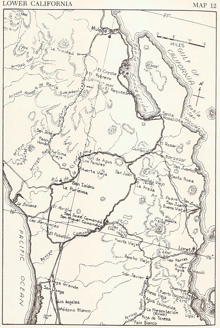
A 1941 road map. The heavy line is the main road south:
The 1962 Howard Gulick map (very accurate):
|
|
|
Tioloco
Ultra Nomad
    
Posts: 4813
Registered: 7-30-2014
Member Is Offline
|
|
Pretty cool old maps
|
|
|
David K
Honored Nomad
        
Posts: 65352
Registered: 8-30-2002
Location: San Diego County
Member Is Offline
Mood: Have Baja Fever
|
|
Old maps are like windows to the past!
|
|
|
4x4abc
Ultra Nomad
    
Posts: 4443
Registered: 4-24-2009
Location: La Paz, BCS
Member Is Offline
Mood: happy - always
|
|
the 1941 map shows the 1930 road
the Gulick map shows the "new" dirt road - don't know when it was built
the paved 1973 road is positioned between the two
the original Camino Real from Loreto to Mulege is between the 1930's road and the paved road, going past Tinaja Las Cruces
Harald Pietschmann
|
|
|
JZ
Select Nomad
      
Posts: 13396
Registered: 10-3-2003
Member Is Offline
|
|
Quote: Originally posted by Nikno  | JZ:
On the San Nicolas thread you posted a map that has "Caves" marked on it. Those caves appear to be within 1 mile of Ensenada de Mangle which is where
the abandoned villas are on that track I posted. There are some roads that go in the direction of the caves but none of them appear to go through. I'm
curious what kind of caves are there and are they worth checking out? Also, do you have exact coordinates?
My thought was next time I'm in the area to either get as close as possible and hike over or launch a kayak from the beach and check it out.
|
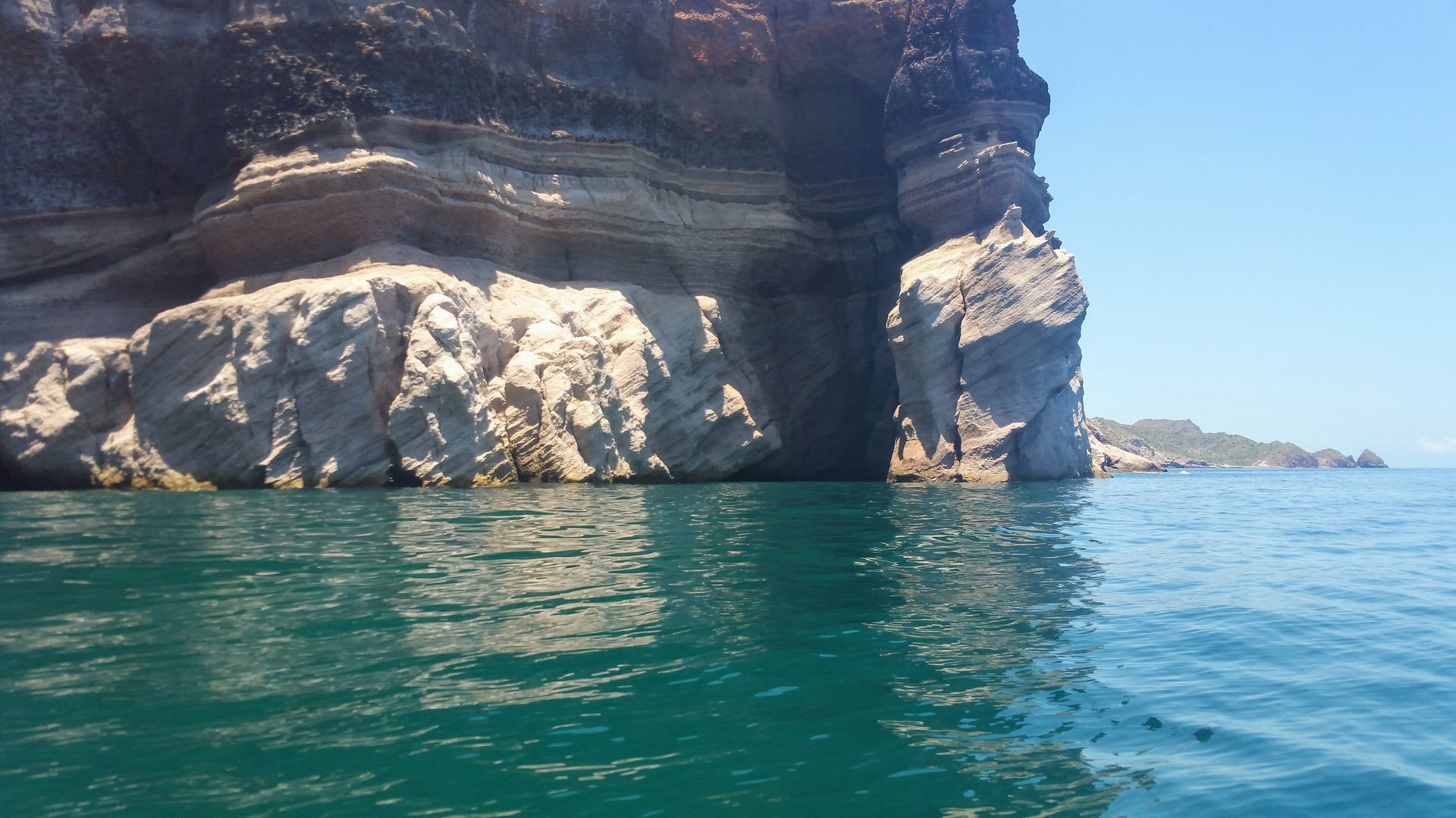
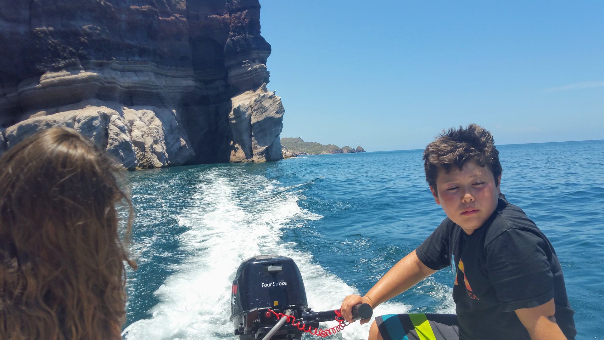
I went there in my boat 3-4 years ago. We took the Zodiac inside of a cave. I have a video of it some where. Will try to post when I get back home.
|
|
|
geoffff
Senior Nomad
  
Posts: 710
Registered: 1-15-2009
Member Is Offline
|
|
Quote: Originally posted by JZ  | | I went there in my boat 3-4 years ago. We took the Zodiac inside of a cave. I have a video of it some where. Will try to post when I get back home.
|
So, these caves would be only accessible by boat? Or could I walk up the beach and then inside?
-- Geoff
|
|
|
JZ
Select Nomad
      
Posts: 13396
Registered: 10-3-2003
Member Is Offline
|
|
Have to be on the water.
|
|
|
JZ
Select Nomad
      
Posts: 13396
Registered: 10-3-2003
Member Is Offline
|
|
Pic of one of the caves.
26.2988820, -111.3820290
[Edited on 9-14-2019 by JZ]
|
|
|
| Pages:
1
2
3 |

