| Pages:
1
2
3
4
5 |
OCEANUS
Nomad
 
Posts: 139
Registered: 10-11-2008
Location: Dana Point; L.A. Bay
Member Is Offline
|
|
Quote: Originally posted by 4x4abc  | every time something with navigation or a location comes up - I revisit the area in Google Earth
this time, checking on Graham, I found a new to me shipwreck
[Edited on 10-30-2019 by 4x4abc] |
I believe that shipwreck is north west of Graham's location and is near Punta Los Machos, a great spot for yellowtail.
|
|
|
4x4abc
Ultra Nomad
    
Posts: 4454
Registered: 4-24-2009
Location: La Paz, BCS
Member Is Offline
Mood: happy - always
|
|
29°20'17.44"N, 113°31'35.11"W
Harald Pietschmann
|
|
|
pniles
Newbie
Posts: 8
Registered: 6-27-2006
Member Is Offline
|
|
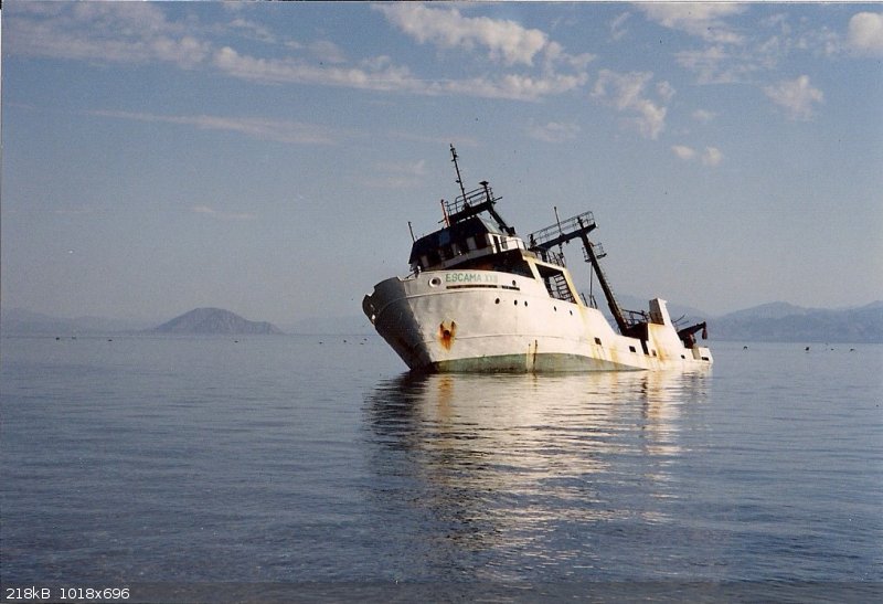
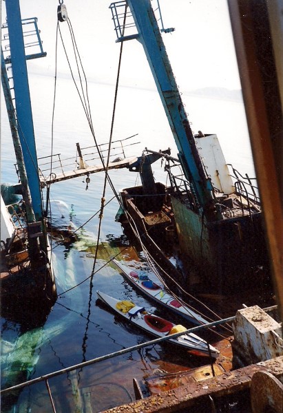
Regarding the ship wreck, I think it is the trawler ESCAMA.
We kayaked from La Gringa and camped at Este Ton in April 1993. A few miles north of Este Ton we encountered the trawler. I took two photos. It seemed
to have been recently abandoned. The grocery lists hanging in the galley were still fresh.
I may have copied this then, or looked it up later on the internet, but I have a note that the ship is: 2317 8030087 ESCAMA XVIII XCKK Trawler 244
1982 11 Mexico.
I asked Graham if he had seen it on his Marooned trip, and he hadn’t, but said his friend “Kayaker John” had photographed in in about 2006.
|
|
|
David K
Honored Nomad
        
Posts: 65410
Registered: 8-30-2002
Location: San Diego County
Member Is Offline
Mood: Have Baja Fever
|
|
Interesting!
|
|
|
Pacifico
Super Nomad
   
Posts: 1299
Registered: 5-26-2008
Member Is Offline
|
|
Very cool!!! That would be fun to explore...
"Plan your life as if you are going to live forever. Live your life as if you are going to die tomorrow." - Carlos Fiesta
|
|
|
David K
Honored Nomad
        
Posts: 65410
Registered: 8-30-2002
Location: San Diego County
Member Is Offline
Mood: Have Baja Fever
|
|
Device Name: grahamspot
Latitude: 29.16119
Longitude: -113.33009
GPS location Date/Time: 10/31/2019 10:33:45 PDT
Message: Happy Halloween. Crossed paths today with a black cat. All's well.
Click the link below to see where I am located.
http://fms.ws/1E0u0C/29.16119N/113.33009W
|
|
|
David K
Honored Nomad
        
Posts: 65410
Registered: 8-30-2002
Location: San Diego County
Member Is Offline
Mood: Have Baja Fever
|
|
I got a message from Graham that he is having a hard time connecting with satellites.
This should be a good warning to those deciding between the Spot X and the Garmin inReach.
The inReach was flawless for me (in 2017 and 2018 traveling for Baja Bound guide research) to connect with Nomads and family, and easy to use. I never
failed to get a message out on the first try. Nomad StuckSucks and I would have two-way chats about what road I was on or what I was seeing there. TW,
Doug, and John M, as well, exchanged messages with me while I was in Baja, with the inReach.
To send Graham a message, I have to do a lot of editing on the reply email and make sure not to exceed 140 characters. The inReach also has a limit on
message size, but it is far more user-friendly. The main thing is that inReach uses the Iridium satellites and Spot does not.
|
|
|
David K
Honored Nomad
        
Posts: 65410
Registered: 8-30-2002
Location: San Diego County
Member Is Offline
Mood: Have Baja Fever
|
|
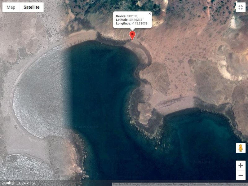
Nov. 1 8:10 am "All is fine"
|
|
|
David K
Honored Nomad
        
Posts: 65410
Registered: 8-30-2002
Location: San Diego County
Member Is Offline
Mood: Have Baja Fever
|
|
Message from Graham 11-1-19
Device Name: grahamspot
Latitude: 29.16250
Longitude: -113.33032
GPS location Date/Time: 11/01/2019 08:52:56 PDT
Message: Great to wake up in Este Ton. Beautiful cove, mountains around. Wind now less. Wild for two days. My 60 lb kayak went rolling down the beach
Click the link below to see where I am located.
http://fms.ws/1E2iZA/29.16250N/113.33032W
|
|
|
David K
Honored Nomad
        
Posts: 65410
Registered: 8-30-2002
Location: San Diego County
Member Is Offline
Mood: Have Baja Fever
|
|
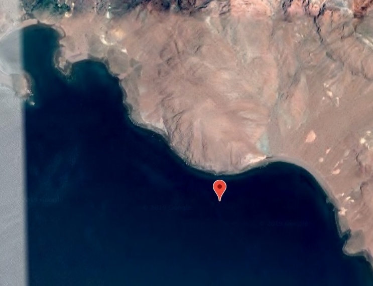
2nd 11-1-19 message and 11-2 location offshore
This came back after I messaged him that I hope it wasn't too cold and if he had lots of firewood available:
Device Name: grahamspot
GPS location Date/Time: 11/01/2019 19:50:54 PDT
The message sender did not share their GPS location with you.
Message: Lots of firewood. Thanks. Only a little cool in morning. Hope to get up early and start shakedown cruise. Fifty yards from shore.
=================================================================
SAT MORNING 6:59 AM LOCATION:
|
|
|
David K
Honored Nomad
        
Posts: 65410
Registered: 8-30-2002
Location: San Diego County
Member Is Offline
Mood: Have Baja Fever
|
|
9:23 AM Saturday... all OK
He is a few miles down the coast of the island...
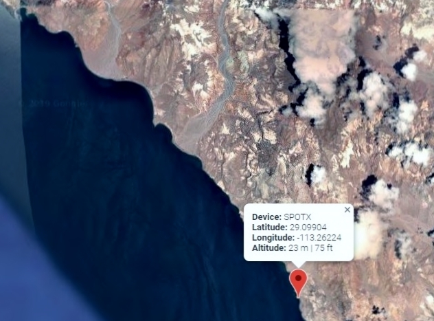
Este Ton is at the top left of this image.
|
|
|
David K
Honored Nomad
        
Posts: 65410
Registered: 8-30-2002
Location: San Diego County
Member Is Offline
Mood: Have Baja Fever
|
|
5:58 pm message Saturday
Device Name: grahamspot
Latitude: 29.09975
Longitude: -113.26251
GPS location Date/Time: 11/02/2019 17:58:02 PDT
Message: Alls well. Camped by big shady arch. Saw finbacks, turtle and dolphins. Paradise here. Can walk through arch 3 ways. Tomorrow to S if calm.
Click the link below to see where I am located.
http://fms.ws/1E5P0a/29.09975N/113.26251W
|
|
|
David K
Honored Nomad
        
Posts: 65410
Registered: 8-30-2002
Location: San Diego County
Member Is Offline
Mood: Have Baja Fever
|
|
4:22 am Sunday
Device Name: grahamspot
Latitude: 29.09298
Longitude: -113.26274
Altitude: -4.0 m | -13 ft
GPS location Date/Time: 11/03/2019 04:23:05 PST
Message: Check-in/OK. All's well. No problems.
Click the link below to see where I am located.
http://fms.ws/1E5xKC/29.09298N/113.26274W
|
|
|
David K
Honored Nomad
        
Posts: 65410
Registered: 8-30-2002
Location: San Diego County
Member Is Offline
Mood: Have Baja Fever
|
|
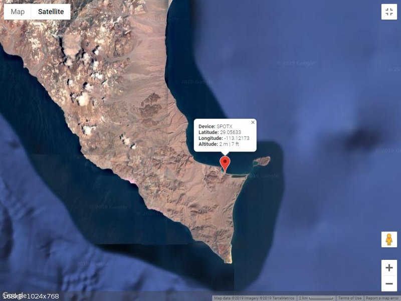
1:09 pm Sunday, around the bottom of the island...
Device Name: grahamspot
Latitude: 29.05633
Longitude: -113.12173
Altitude: 2.0 m | 7 ft
GPS location Date/Time: 11/03/2019 13:09:54 PST
Message: Check-in/OK. All's well. No problems.
Click the link below to see where I am located.
http://fms.ws/1E6dpQ/29.05633N/113.12173W
|
|
|
David K
Honored Nomad
        
Posts: 65410
Registered: 8-30-2002
Location: San Diego County
Member Is Offline
Mood: Have Baja Fever
|
|
5:48 PM Sunday Message
Device Name: grahamspot
Latitude: 29.05624
Longitude: -113.12197
GPS location Date/Time: 11/03/2019 17:48:58 PST
Message: Hi David. Great paddling day. Left hour before dawn. Glowing and sparkling sea. Yesterday was testing and finding shelter early. Today work.
Click the link below to see where I am located.
http://fms.ws/1E6-Gu/29.05624N/113.12197W
|
|
|
David K
Honored Nomad
        
Posts: 65410
Registered: 8-30-2002
Location: San Diego County
Member Is Offline
Mood: Have Baja Fever
|
|
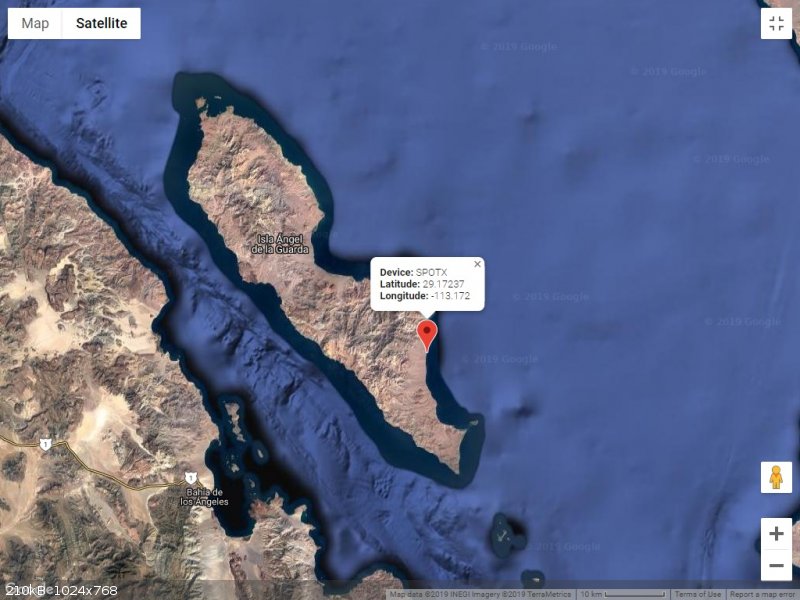
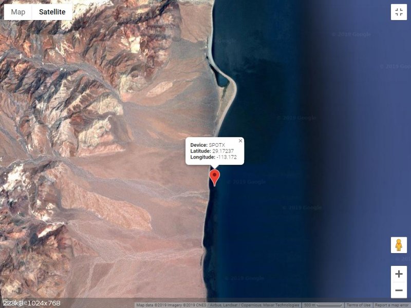
8:45 am Monday... Moving up the island's east coast
Device Name: grahamspot
Latitude: 29.17237
Longitude: -113.17203
Altitude: -10.0 m | -33 ft
GPS location Date/Time: 11/04/2019 08:45:23 PST
Message: Check-in/OK. All's well. No problems.
Click the link below to see where I am located.
http://fms.ws/1E80WY/29.17237N/113.17203W
|
|
|
David K
Honored Nomad
        
Posts: 65410
Registered: 8-30-2002
Location: San Diego County
Member Is Offline
Mood: Have Baja Fever
|
|
On the move!
Monday 2:51 pm:
Device Name: grahamspot
Latitude: 29.28575
Longitude: -113.20229
Altitude: -4.0 m | -13 ft
GPS location Date/Time: 11/04/2019 14:51:41 PST
Message: Check-in/OK. All's well. No problems.
Click the link below to see where I am located.
http://fms.ws/1E8iT6/29.28575N/113.20229W
Monday 6:58 pm Message:
Device Name: grahamspot
Latitude: 29.28581
Longitude: -113.20220
GPS location Date/Time: 11/04/2019 18:58:05 PST
Message: Thanks David. Perfect. Long day today. Using good weather to cover miles. So glad to round Punta Rocosa. Awesome. One more day then DS water
Click the link below to see where I am located.
http://fms.ws/1E922l/29.28581N/113.20220W
Tuesday 8:11 am:
Device Name: grahamspot
Latitude: 29.29223
Longitude: -113.26613
Altitude: -4.0 m | -13 ft
GPS location Date/Time: 11/05/2019 08:11:45 PST
Message: Check-in/OK. All's well. No problems.
Click the link below to see where I am located.
http://fms.ws/1EA1GI/29.29223N/113.26613W
Tuesday 9:25 am:
Device Name: grahamspot
Latitude: 29.29049
Longitude: -113.31035
Altitude: -1.0 m | -3 ft
GPS location Date/Time: 11/05/2019 09:26:13 PST
Message: Check-in/OK. All's well. No problems.
Click the link below to see where I am located.
http://fms.ws/1EAAkB/29.29049N/113.31035W
Can you guys see the map okay by clicking the links? If anyone needs me to keep making them, let me know.
|
|
|
AKgringo
Elite Nomad
     
Posts: 6281
Registered: 9-20-2014
Location: Anchorage, AK (no mas!)
Member Is Offline
Mood: Retireded
|
|
The link works fine, and a little playing around with it gets me to what you have been posting. Do you know what Graham means by "DS" water?
[Edited on 11-5-2019 by AKgringo]
If you are not living on the edge, you are taking up too much space!
"Could do better if he tried!" Report card comments from most of my grade school teachers. Sadly, still true!
|
|
|
David K
Honored Nomad
        
Posts: 65410
Registered: 8-30-2002
Location: San Diego County
Member Is Offline
Mood: Have Baja Fever
|
|
De-Salinated
|
|
|
David K
Honored Nomad
        
Posts: 65410
Registered: 8-30-2002
Location: San Diego County
Member Is Offline
Mood: Have Baja Fever
|
|
More travel on Tuesday...
3:59 pm:
Device Name: grahamspot
Latitude: 29.39419
Longitude: -113.36253
Altitude: -1.0 m | -3 ft
GPS location Date/Time: 11/05/2019 15:59:45 PST
Message: Check-in/OK. All's well. No problems.
Click the link below to see where I am located.
http://fms.ws/1EAyRb/29.39419N/113.36253W
7:50 PM MESSAGE:
Device Name: grahamspot
Latitude: 29.39414
Longitude: -113.36274
GPS location Date/Time: 11/05/2019 19:50:07 PST
Message: Another long day. After calm start was battling headwinds and tide. But wanted to get around Punta Pulpito before resting to make water.
Click the link below to see where I am located.
http://fms.ws/1EBFZY/29.39414N/113.36274W
8:06 PM MESSAGE:
Message: Amazing place. Would be surprised if I met anyone. But so many birds, dolphins, sealions, turtles and fish boils. Return to North winds.
|
|
|
| Pages:
1
2
3
4
5 |

