| Pages:
1
2
3
4 |
Don Pisto
Banned
Posts: 1282
Registered: 8-1-2018
Location: El Pescador
Member Is Offline
Mood: weary like everyone else
|
|
The veteran racer says the real adventure starts when you break down.
“I got into this for the adventure,” he says. “It wasn’t because of the racing; it was the thrill of the unknown.”
Ivan the "Ironman" Stewart
there's only two things in life but I forget what they are........
John Hiatt
|
|
|
mtgoat666
Platinum Nomad
       
Posts: 20555
Registered: 9-16-2006
Location: San Diego
Member Is Offline
Mood: Hot n spicy
|
|
Quote: Originally posted by JZ  | You all don't want to break down or get stuck on that trail.
Now that Coco's has moved, traffic is less and the distance to hike to for help is a lot further.
Better have a plan. My truck is a lot more capable than a 2wd van and I'd think real hard about taking my truck on that trail alone.
|
Shorty,
Don’t be a girly man. Your truck can venture further than the mall. Take some extra water, and sturdier shoes than flip flops, and even you can
drive a rough unpaved road.
Turn around before you get stuck (not after you get stuck)..
Drive slow, your truck won’t break.

Woke!
Hands off!
“Por el bien de todos, primero los pobres.”
“...ask not what your country can do for you – ask what you can do for your country.” “My fellow citizens of the world: ask not what America
will do for you, but what together we can do for the freedom of man.”
Pronoun: the royal we
|
|
|
John Harper
Super Nomad
   
Posts: 2289
Registered: 3-9-2017
Location: SoCal
Member Is Offline
|
|
Quote: Originally posted by mtgoat666  | Quote: Originally posted by JZ  | You all don't want to break down or get stuck on that trail.
Now that Coco's has moved, traffic is less and the distance to hike to for help is a lot further.
Better have a plan. My truck is a lot more capable than a 2wd van and I'd think real hard about taking my truck on that trail alone.
|
Shorty,
Don’t be a girly man. Your truck can venture further than the mall. Take some extra water, and sturdier shoes than flip flops, and even you can
drive a rough unpaved road.
Turn around before you get stuck (not after you get stuck)..
Drive slow, your truck won’t break.
 |
Maybe he should just stay in his basement, like he tells the rest of us.
John
|
|
|
geoffff
Senior Nomad
  
Posts: 710
Registered: 1-15-2009
Member Is Offline
|
|
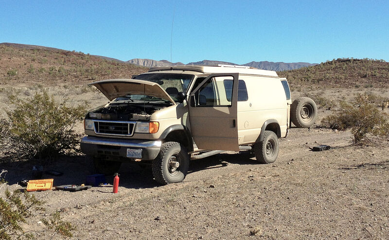
And the thing about this Ironman aspect of "adventure" is that it isn't necessarily fun in the heat of the moment. It's fun afterwards when you think
back on what you accomplished, and tell the stories.
|
|
|
geoffff
Senior Nomad
  
Posts: 710
Registered: 1-15-2009
Member Is Offline
|
|
[Edited on 9-30-2021 by geoffff]
|
|
|
JZ
Select Nomad
      
Posts: 13928
Registered: 10-3-2003
Member Is Online
|
|
Quote: Originally posted by mtgoat666  |
Shorty,
Don’t be a girly man. Your truck can venture further than the mall. Take some extra water, and sturdier shoes than flip flops, and even you can
drive a rough unpaved road.
Turn around before you get stuck (not after you get stuck)..
Drive slow, your truck won’t break.
 |
I would just drop my bike down off the truck and ride out.
But, what are you even talking about, you are afraid to go near the SOC side if the temps are above 80 degrees. So, I don't want to hear anything
from your mouth.
|
|
|
advrider
Super Nomad
   
Posts: 1920
Registered: 10-2-2015
Member Is Offline
|
|
I've ridden that wash many times on my 500 and even 990, it is deep sand. Everyone has a risk level they are comfortable with, I've been
fourwheeling/rock crawling for years but have not done a lot of sand driving. I wouldn't run a 2wd up that wash unless I was with other, 4wd no
problem. With Coco gone it will be much more remote and see a lot less traffic, so plan a head. Please report back so we know how it goes...
|
|
|
David K
Honored Nomad
        
Posts: 65435
Registered: 8-30-2002
Location: San Diego County
Member Is Offline
Mood: Have Baja Fever
|
|
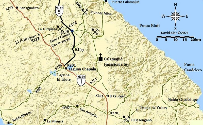
Coco's Corner is not gone, he moved 4 miles north to where the original road to Calamajué left the road from Gonzaga to Chapala (at Las Arrastras).
|
|
|
TinCanAdventureVan
Newbie
Posts: 12
Registered: 9-29-2021
Member Is Offline
|
|
I didn't realize Coco had moved. Does anyone happen to have the coordinates of where he's located now?
I'll report back on the trip when I return. I guess if you don't hear from me I either forgot or I got stuck and am living in the canyon!
On another note is there anything you guys recommend checking out on the way from San Felipe to the border? I've got plenty of things to look at on my
way down from San Diego to L.A. Bay but for the drive north I'll be taking highway 5 most likely and I don't really have anything on the list north of
San Felipe. I noticed the Guadalupe Canyon hot springs but I havent really read about the road out that way yet or if the hot springs are worth
visiting. The hot springs in California I've gone to tend to be a bit disappointing.
Thanks everyone!
|
|
|
advrider
Super Nomad
   
Posts: 1920
Registered: 10-2-2015
Member Is Offline
|
|
I meant that Coco moved across the way so I don't think there will be as much traffic out that way, you won't miss his new spot. I've always wanted to
check out the water fall / Oasis outside of SF across the dry lake bed, sorry don't have the name on hand.
Always worth going over Laguna Hansen on the way back, maybe even stay the night in the park?
|
|
|
4x4abc
Ultra Nomad
    
Posts: 4454
Registered: 4-24-2009
Location: La Paz, BCS
Member Is Offline
Mood: happy - always
|
|
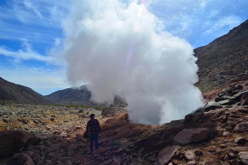
go see the Fumarole!
Harald Pietschmann
|
|
|
4x4abc
Ultra Nomad
    
Posts: 4454
Registered: 4-24-2009
Location: La Paz, BCS
Member Is Offline
Mood: happy - always
|
|
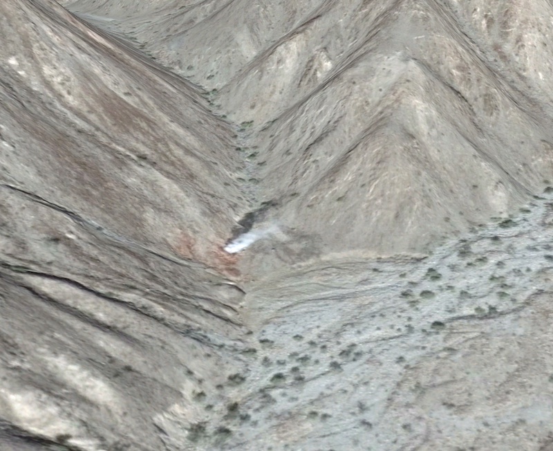
the Fumarole is a steam geyser "born" during the 2010 earthquake
it is even visible on sat images
32°19'36.40"N, 115°25'1.41"W
https://www.youtube.com/watch?v=fl8rgEin-bY
Harald Pietschmann
|
|
|
4x4abc
Ultra Nomad
    
Posts: 4454
Registered: 4-24-2009
Location: La Paz, BCS
Member Is Offline
Mood: happy - always
|
|
you have to hike the last 3/4 mile
only the bravest of 4x4 have driven all the way
26 km - 16 miles from pavement
Attachment: 4x4 rural to Fumarole 26 km, 16 miles.kmz (9kB)
This file has been downloaded 289 times
Harald Pietschmann
|
|
|
TinCanAdventureVan
Newbie
Posts: 12
Registered: 9-29-2021
Member Is Offline
|
|
Wow that geyser looks amazing!
I havent heard about the waterfall/Oasis west of SF. I've only heard of the one further south near Cataviña. Ive seen it called several things but
often referred to as the Santa Maria Oasis. Looks like a far hike from Cataviña but it appears you can drive to within about 5 miles of it from the
east without having to do any rock crawling and then hike the rest of the way. Have any of you been there?
|
|
|
geoffff
Senior Nomad
  
Posts: 710
Registered: 1-15-2009
Member Is Offline
|
|
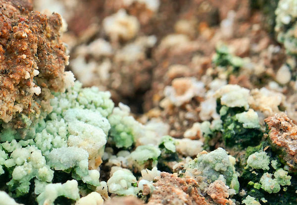
The fumarole is curious. Alien landscape. Worth a visit if you are in the area!


|
|
|
geoffff
Senior Nomad
  
Posts: 710
Registered: 1-15-2009
Member Is Offline
|
|
Yeah, many discussions here on Baja Nomad of the Santa Maria Oasis. Use the Search function!
Here's a recent one to get you started:
Hike to Oasis Santa Maria from Gonzaga side
|
|
|
TinCanAdventureVan
Newbie
Posts: 12
Registered: 9-29-2021
Member Is Offline
|
|
Perfect thanks I'll dive in, no need to bring the discussion to this thread!
|
|
|
Maderita
Senior Nomad
  
Posts: 695
Registered: 12-14-2008
Location: San Diego
Member Is Offline
|
|
Quote: Originally posted by TinCanAdventureVan  |
On another note is there anything you guys recommend checking out on the way from San Felipe to the border? I've got plenty of things to look at on my
way down from San Diego to L.A. Bay but for the drive north I'll be taking highway 5 most likely and I don't really have anything on the list north of
San Felipe. I noticed the Guadalupe Canyon hot springs but I havent really read about the road out that way yet or if the hot springs are worth
visiting... |
I'm guessing that you do know about the hot springs at Puertecitos? It is best to time it according to the tides to get the best mix of seawater for
ideal temperatures.
The "waterfall/oasis" west of SF that you are referring to is likely the palm canyon, Cañón del Diablo, which descends from 10,000' Picacho del
Diablo to the desert. A stream flows over granite and creates some pools big enough to swim. You may have seen photos of a rope and rope ladder to
pass the pools hiking up the canyon. A more obscure palm canyon is
Cañón Providencia, another steep canyon descending from the mountain, a few miles to the south. If you are interested, search "Tina del Rey
Providencia". A couple guide services have started guiding wilderness hiking trips there.
Going north from San Felipe on Mex 5, well don't fall asleep at the wheel. Long and boring flat desert for the most part. Cañón de Guadalupe is
unique. Visiting on weekdays may be more to your liking. It gets busy on weekends and holidays. http://guadalupecanyonoasis.com/index.html
It is possible to cut across Laguna Salada from Mex 5 in dry weather. Don't try it if there has been significant, though rare, rain. If you are
driving south to Canyon Guadalupe from Mex 2D, the eastern of the two roads is smooth and fast across the dry lake bed of Laguna Salada. The road
exits 2D at the large Pavarotti sign. If there has been significant rain, take the western, high, road around the lake to avoid the 30 miles of soft
mud.
October is almost always a nice month in the Sierra de Juárez. Elevations to 5,000', pine trees, granite crags, and a national park at Laguna Hanson.
The lake will be dry in October, but becomes a pleasant meadow to visit, picnic, or camp. You could drive north from SF and take Mex 3 (toward
Ensenada), then go north from Ojos Negros to the Parque Nacional Constitución de 1857. From Laguna Hanson, you can continue north to the town of La
Rumorosa at Mex 2, another 2 hours/40 miles. 2WD except during winter storms.
Driving north from Laguna Hanson, approx 14 miles, a 2 mile detour to the west of the Laguna Hanson road will take you to Rancho El Topo. A lovely
place among Jeffrey pines for camping, hiking, and nearby rock climbing. Secure camping on the gated ranch is 100 pesos per night, per adult. The
Sandovals welcome visitors. Weekends visits are best, there is more going on, yet it is easy to camp away from others. Horseback riding available on
weekends. Betito will guide to a nearby small lake, 1.5 hours total, for I believe 400 pesos ($21). Should you happen by the ranch on October 22-24, I
will be hosting a large fiesta for rock climbers.
https://www.facebook.com/RanchoElTopoSierraDeJuarez
In the town of La Rumorosa, La Cabaña del Abuelo restuarant is wonderful. Tortillas made fresh in the middle of the restaurant while you eat. Next
door to the one PEMEX station, near the west side of town.
https://www.facebook.com/lacabanadelabuelorestaurant
Just north of the 2D on the west side of La Rumorosa is a gated park for viewing Native American cave paintings. Admission is quite inexpensive, with
secure parking. Self-guided loop trail; figure 45 minutes - 1 hour.
The west Rumorosa exit from the 2D, signed Rumorosa/Vallecito. KM 68 if I recall correctly. If already in town on Mex 2 (libre/free road), there is a
cut-across road about a mile west of the PEMEX.
https://en.wikipedia.org/wiki/El_Vallecito
|
|
|
TinCanAdventureVan
Newbie
Posts: 12
Registered: 9-29-2021
Member Is Offline
|
|
Wow those are some great tips Maderita!
I've actually been to the hot springs at Puertecitos and had a great time soaking there. I think I noticed on google maps theyre marked as temporarily
closed but I will probably check it out and see what the story is. I saw someone online complaining that they charge to much for the hot springs and
that there's free ones further south but I remember when I went maybe years ago thinking the price was fine.
I really like your idea of taking Mex 3 and climbing into the mountains. I think you may have changed the last leg of my trip! a 2wd van should handle
those roads from Ojos Negros to Laguna Hanson and on to La Rumorosa? I was planning on stopping to see the pictographs there.
Seriously thank you for all of your help and ideas! I wish I was going to be around still for your rock climbing gathering!
|
|
|
David K
Honored Nomad
        
Posts: 65435
Registered: 8-30-2002
Location: San Diego County
Member Is Offline
Mood: Have Baja Fever
|
|
Baja has an endless supply of interesting sites. One trip will only tease your need to return.
Coco's new Corner is on my map (km.179.5) just off the highway.
The Santa María Mission requires a high clearance 4x4. The oasis (there are several) you may have seen requires difficult hiking.
Just enjoy what you do see and come back for more! I have been coming back all my life!!
|
|
|
| Pages:
1
2
3
4 |

