| Pages:
1
2
3
4
5
6 |
WideAngleWandering
Nomad
 
Posts: 416
Registered: 3-13-2012
Location: US-Based but traveling
Member Is Offline
|
|
Cool deal but who would I be saying hello to?
I drive by a lot of ranchos - I'm never sure if they are just working ranches or the kind of places that host visitors. If I am cruising by and
hungry I'll definitely stop in.
|
|
|
thebajarunner
Ultra Nomad
    
Posts: 3754
Registered: 9-8-2003
Location: Arizona....."Free at last from crumbling Cali
Member Is Offline
Mood: muy amable
|
|
Meling is a well known working ranch and also a guest ranch.
Trust me, just stop in and introduce yourself and tell them you are a Nomad.
They run cattle on about a gazillion acres, maybe more.
And, it is about half way up the hill- you cannot miss it,
and you will be happy you stopped.
|
|
|
David K
Honored Nomad
        
Posts: 65442
Registered: 8-30-2002
Location: San Diego County
Member Is Offline
Mood: Have Baja Fever
|
|
Did you look at my photos since I have been back, two weeks ago? There could be some places you would like to see... In the Baja Trip Reports form "15
Days in Baja..."
|
|
|
QUETZALCOATL
Nomad
 
Posts: 118
Registered: 8-1-2012
Location: coming from or going to Baja
Member Is Offline
Mood: nublado
|
|
Doors locked-check,missing out on Baja check.
|
|
|
captkw
Ultra Nomad
    
Posts: 3850
Registered: 10-19-2010
Location: el charro b.c.s.
Member Is Offline
Mood: new dog/missing the old 1
|
|
queztel????
umm ......................WHAT???? my folks have not locked the doors on our house ever!!!! east cape 30 +yrs...K&T
|
|
|
WideAngleWandering
Nomad
 
Posts: 416
Registered: 3-13-2012
Location: US-Based but traveling
Member Is Offline
|
|
I'm confuzzled.
|
|
|
David K
Honored Nomad
        
Posts: 65442
Registered: 8-30-2002
Location: San Diego County
Member Is Offline
Mood: Have Baja Fever
|
|
Please update us with your location when you check in here! Have a great trip...
David
|
|
|
WideAngleWandering
Nomad
 
Posts: 416
Registered: 3-13-2012
Location: US-Based but traveling
Member Is Offline
|
|
I've had an interesting few days for sure. I'll write more in a bit but the summary is:
* got lost in the sierras - never found that observatory
* thrashed my steering pretty good while trying to make my way out
* crawled out and camped at a rancho with a couple of helpful friendly rooster ranchers
* drove muy despacio to Ensenada. Checked in at the Hotel Santo Tomas while I try to figure out how to diagnose and acquire parts for Betsy (she was
named by the previous owner - it's stenciled into the seat cover so the name sticks for now).
I'm pretty sure I'm going to have to gets parts from the states for this one. Ug.
|
|
|
thebajarunner
Ultra Nomad
    
Posts: 3754
Registered: 9-8-2003
Location: Arizona....."Free at last from crumbling Cali
Member Is Offline
Mood: muy amable
|
|
Sorry to hear about your problems.
| Quote: | Originally posted by WideAngleWandering
I've had an interesting few days for sure. I'll write more in a bit but the summary is:
* got lost in the sierras - never found that observatory
* thrashed my steering pretty good while trying to make my way out
* crawled out and camped at a rancho with a couple of helpful friendly rooster ranchers
* drove muy despacio to Ensenada. Checked in at the Hotel Santo Tomas while I try to figure out how to diagnose and acquire parts for Betsy (she was
named by the previous owner - it's stenciled into the seat cover so the name sticks for now).
I'm pretty sure I'm going to have to gets parts from the states for this one. Ug. |
However, you have established a "Baja First"
No one has ever previously failed to find the observatory.
Are you sure you were in the mountains?
Make a parts list and post it on Nomad
someone may be coming your way and haul them down,
otherwise the bus to TJ is quick, cheap and comfortable
so you have that option.
(Are you sure you were on the right road? It goes straight to the sky station.... oh well, good try)
|
|
|
BajaBlanca
Select Nomad
      
Posts: 13247
Registered: 10-28-2008
Location: La Bocana, BCS
Member Is Offline
|
|
what a shame ..... hopefully you get Betsy up and running rapido so you can continue your journey .... hey, it is all an adventure !
|
|
|
WideAngleWandering
Nomad
 
Posts: 416
Registered: 3-13-2012
Location: US-Based but traveling
Member Is Offline
|
|
I'm really confused about that myself but I'll post up details later so y'all can straighten me out.
As for the truck, I'm not sure what I need yet but I figure worst case I can get parts sent to a friend in San Diego and bus it like ya said.
I had a good time at the rooster ranch though 
|
|
|
David K
Honored Nomad
        
Posts: 65442
Registered: 8-30-2002
Location: San Diego County
Member Is Offline
Mood: Have Baja Fever
|
|
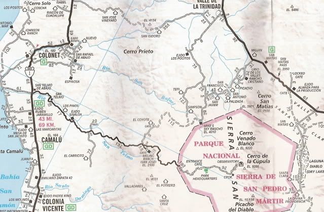
Okay, place names help a lot... From what I recall reading, you entered at Mexicali, but then continued west along the border to La Rumorosa. Then you
headed south to Laguna Hanson then on southeast to San Felipe...
So, somehow you went back northwest on Hwy. 3(?) to maybe San Matias(?) then south to Mike's Sky Rancho(?) trying to get to the observatory?
It is a tough 4WD road from Mike's south to the observatory highway... and yes, it is a paved highway all the way to 9,280' that starts on Hwy. 1,
south of Ensenada (between Colonet and Camalu). So, to get to the observatory there is only one way once you are near the Meling Guest Ranch (which is
just east of where the 4WD Mike's Sky Rancho road meets the observatory road, also is the road for El Coyote guest ranch).
Please fill us in on just where you entered the sierra coming from San Felipe, and if you didn't get to Mike's Sky Rancho (20 miles from Hwy. 3), then
you would have dead ended in a rancher's front yard.
I hope you get the truck fixed... In Baja, you do want to have as few mechanical issues as possible... but some of us can help IF we know where you
are or where you are going next!


[Edited on 8-16-2012 by David K]
|
|
|
WideAngleWandering
Nomad
 
Posts: 416
Registered: 3-13-2012
Location: US-Based but traveling
Member Is Offline
|
|
Hi David,
You're correct - I came down Mexicali, took MX-2 to La Rumorosa, south to Laguna Hanson but instead of continuing on to the observatory right away I
fled the thunderstorms and went to the coast.
I then backtracked up MX-3 and turned south at the sign for Mike's Sky Ranch. I camped there for the night (ug, that was not a great choice) and got
directions from them about getting to the observatory road.
They said the road would be difficult at first, with loose rocks, but then it gets better. There would be Y in the road with the left going to the
observatory and the right a cattle gate to Rancho Coyote.
I followed it for about two hours. I saw a sign for Coyote (8 miles) and then another one further on near some trees and greenery. I never saw the
cattle gate.
A bit further down the road ended at a creek bed. It was completely washed out with sharp walls. I scouted the area a bit and found a steep dirt
descent down to the creekbed (about a 10' ramp) but the creek bed was impassable due to large rocks. On the other side it appeared the road continued
but it was washed out and only wide enough for a motorcycle.
At this point I decided to backtrack and look for another route. It was while crawling out that I broke poor Betsy's steering.
Back at Rancho Mike Sky I talked to them some more and they said the road should be passable because cars & trucks go back there at least once a
week and don't come back. Perhaps I missed the gate to Coyote and through there is another way back onto the road south to the observatory.
They described two more options for me - one going east from Mike's Sky Ranch to Rancho Concepción (they charge $8 to cross their ranch) and another
going north to the sand road by the Mike's Sky Ranch sign, following that NE to Valle Trinidad and then back south to the observatory road.
I opted for the Valle Trinidad route but aborted due to mechanical issues. Instead I hung out with Oscar and Jose at Rancho Jose (with all the beer
cans stuck to the cactus plants).
Now I'm in Ensenada. Once I fix the truck (no idea what that is going to take yet) I'm going back down MX-1 to the observatory road because there is
no way I'm not driving up there after all this trouble 
|
|
|
WideAngleWandering
Nomad
 
Posts: 416
Registered: 3-13-2012
Location: US-Based but traveling
Member Is Offline
|
|
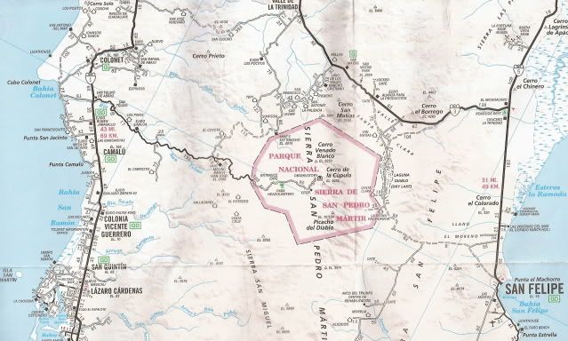
Oh and where did you get those maps?
I have asked at every place I could think of and the best I have scored is a Guía Roja.
|
|
|
David K
Honored Nomad
        
Posts: 65442
Registered: 8-30-2002
Location: San Diego County
Member Is Offline
Mood: Have Baja Fever
|
|
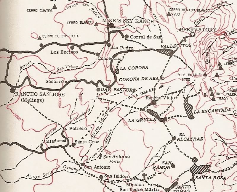
Okay, that is what I figured... although I didn't guess you went passed Mike's and got lost. Do you see the first map with my mileages next to one
route? Well, that is the way we went to Mike's from the observatory road to Hwy. 3, back in 2005: The trip was from San Quintin to San Felipe: http://vivabaja.com/905 there is a road log in that trip report page, too.
The maps are from:
The Baja California Almanac (2003 edition).
Camping and Climbing in Baja (1972 edition)
Auto Club of Southern California (2007 edition)
Oh, and Rancho Concepcion is mow the Baja Dark Skies Inn and Baja Nomad member 'AstroBaja' (Mike). There is no charge, but you need to ask him to
unlock the gate for you... too late and you didn't find it... http://www.bajadarkskies.com/index.html
[Edited on 8-16-2012 by David K]
|
|
|
WideAngleWandering
Nomad
 
Posts: 416
Registered: 3-13-2012
Location: US-Based but traveling
Member Is Offline
|
|
I did see your road log but my odometer is metric and not entirely accurate due to tire sizes & other mods.
The thing I don't understand is, was the road recently damaged or did I completely miss a turn-off somewhere? Does one have to go through the mystery
cattle gate and on to rancho coyote? The map says otherwise.
To diagnose my issue I think I'm going to need to pull the tie rods off the wheels and possibly the pitman arm. I don't have the tools for the tie
rods. I'm going to start asking around for a mechanic but if anyone knows of a good one I'd love a suggestion. Vehicle is an Toyota '84 Landcruiser
(never sold in Mexico).
|
|
|
David K
Honored Nomad
        
Posts: 65442
Registered: 8-30-2002
Location: San Diego County
Member Is Offline
Mood: Have Baja Fever
|
|
Well, El Coyote is just 1/4 mile off the route we took... and you could have used our route or the slightly longer road right into El Coyote. I
photographed a sign pointing that route out. That is the El Corral Falso route, 5.1 miles from Mike's.

Two roads go east to Los Encinos (the old Mike's airport) and on to Baja Dark Skies Inn (Concepcion)... not shown, but where the road crosses the
creek, south of 'San Pedro (ab)'. That road continues south to the observatory road... where the fire was burning in AstroBaja's post... by El
Socorro.
|
|
|
WideAngleWandering
Nomad
 
Posts: 416
Registered: 3-13-2012
Location: US-Based but traveling
Member Is Offline
|
|
I can't make heads of tails of this but Betsy seems to have auto-repaired herself. Perhaps I have redeemed myself in the eyes of the Pai Pai and they
lifted their curse.
Seriously, I have no idea. Not three hours ago I was struggling to maneuver around town and now it's all good. Rock stuck in the steering column?
Who knows.
So to take this back to planning - any recommendations for a night in Ensenada? 
|
|
|
WideAngleWandering
Nomad
 
Posts: 416
Registered: 3-13-2012
Location: US-Based but traveling
Member Is Offline
|
|
Here is a google map showing where I stopped and turned back. I made this by exporting the GPX file from my Garmin via Basecamp, importing into
Google Earth, exporting to KML and importing to Google Maps. GPS datums unknown.
https://maps.google.com/maps/ms?msid=201257090310765426703.0...
|
|
|
WideAngleWandering
Nomad
 
Posts: 416
Registered: 3-13-2012
Location: US-Based but traveling
Member Is Offline
|
|
here is the last Rancho Coyote sign that I saw:
https://picasaweb.google.com/lh/photo/i7ZqI2uuA5D9sJaq9eOCMt...
A short while later (sorry - didn't track the miles - maybe 20 mins or so) the road ended in this creek bed:
https://picasaweb.google.com/lh/photo/Hl4aOUl4AlARCYKLRWayBt...
The photo doesn't make this clear but there's no way down from here and on the other side the road is too narrow anyway:
https://picasaweb.google.com/lh/photo/IqYvm1XXtU9PCcp_l4rIHN...
Here's the path down to the creek bed - it's far too steep for my vehicle - I'd have dragged the rear end all the way down, not to mention those big
rocks in the way:
https://picasaweb.google.com/lh/photo/HiumYcGcpCmkK3tUgrJtMd...
[Edited on 2012-8-17 by WideAngleWandering]
|
|
|
| Pages:
1
2
3
4
5
6 |

