| Pages:
1
2
3 |
David K
Honored Nomad
        
Posts: 65436
Registered: 8-30-2002
Location: San Diego County
Member Is Offline
Mood: Have Baja Fever
|
|
After crossing the Sierra Pinta, it went probably in a straight line towards San Felipe, and not swing east to El Chinero as the 1962 map shows
(unless it met up with the dirt road to San Felipe and followed it south)? There is just so little details on this, perhaps because it was top secret
at the time?
|
|
|
willardguy
Elite Nomad
     
Posts: 6451
Registered: 9-19-2009
Member Is Offline
|
|
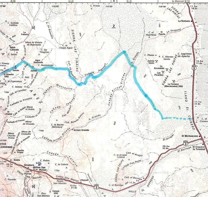
david, could you show a modern day map showing the entire route of this pole line road?
|
|
|
David K
Honored Nomad
        
Posts: 65436
Registered: 8-30-2002
Location: San Diego County
Member Is Offline
Mood: Have Baja Fever
|
|
| Quote: | Originally posted by willardguy
david, could you show a modern day map showing the entire route of this pole line road? |
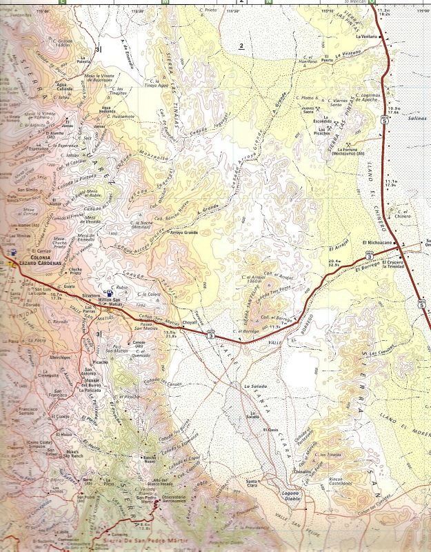
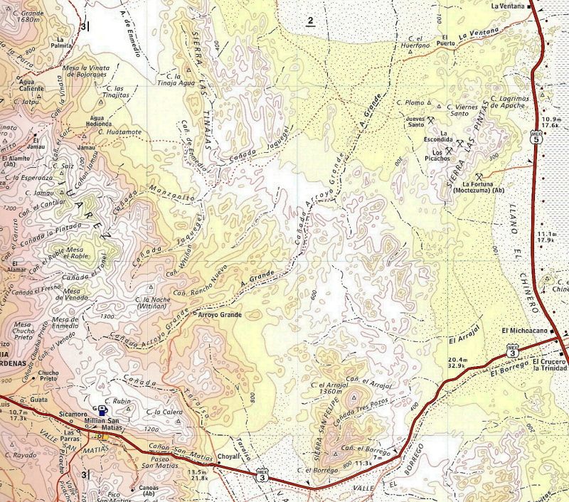
Okay, the pole line road serviced the installation of a telephone line between Ensenada and San Felipe constructed ca 1943 to facilitate
communications with the American Radar Station at Punta Diggs, (San Felipe) installed to detect Japanese (or German?) attacks coming up the Gulf of
California. The summit road (Portezuelo de Jamau) was built in 1943 for the telephone line.
As in other cases (such as the El Camino Real of the 1700's), roads built in the desert can be seen for many years and gives us a look into history.
The area we call the Pole Line Road is very remote, even today... and some of the wooden poles are still standing... insulators have been collected...
and the cobblestone roadbed still can be seen.
Once across the Arroyo Grande, the oleline road headed for San Felipe and the last trace of it can be seen north of Hwy. 3 and west of El Chinero.
|
|
|
willardguy
Elite Nomad
     
Posts: 6451
Registered: 9-19-2009
Member Is Offline
|
|
good stuff, thanks david!
|
|
|
TMW
Select Nomad
      
Posts: 10659
Registered: 9-1-2003
Location: Bakersfield, CA
Member Is Offline
|
|
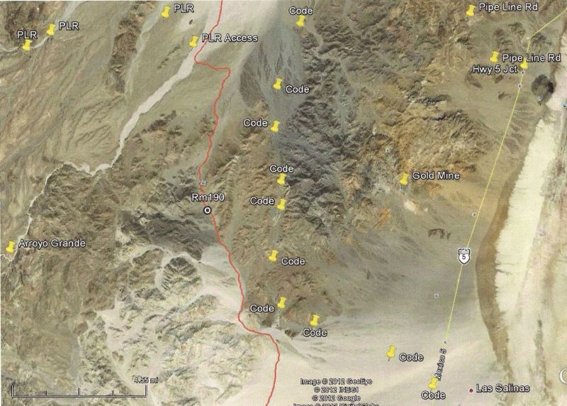
I never thought of the PLR running south, I assumed it when over to La Ventana then south following the hwy to San Felipe. Here are two routes going
south. SCORE use to run the SF250 race up the CODE route then back down the 500/1000 route shown in red.
|
|
|
David K
Honored Nomad
        
Posts: 65436
Registered: 8-30-2002
Location: San Diego County
Member Is Offline
Mood: Have Baja Fever
|
|
56MM# : would really like to see more of your photos... anyone else have photos driving in Arroyo Grande from the Pole Line Rd. crossing (and SCORE
course) south into the first canyon? The cable stopped us 2 years ago, but 56MM# said it wasn't there anymore.
|
|
|
Ken Cooke
Elite Nomad
     
Posts: 8970
Registered: 2-9-2004
Location: Riverside, CA
Member Is Offline
Mood: Pole Line Road postponed due to injury
|
|
Looking back up Jaquel Canyon ('Skateboard Ramp' obstacle)

Arroyo Grande (looking upstream)

Jaquegel

Arroyo Grande 2004 (looking towards Hwy 5)

Arroyo Grande (looking towards La Ventana)


|
|
|
David K
Honored Nomad
        
Posts: 65436
Registered: 8-30-2002
Location: San Diego County
Member Is Offline
Mood: Have Baja Fever
|
|
Ken (and other Nomads)...
Here is the area of Arroyo Grande I would like to see photos of, the narrow lower canyon part... south of where the Pole Line Road (blue line) crosses
it...
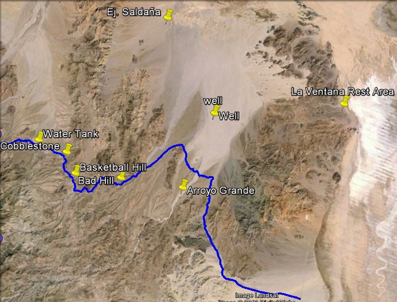
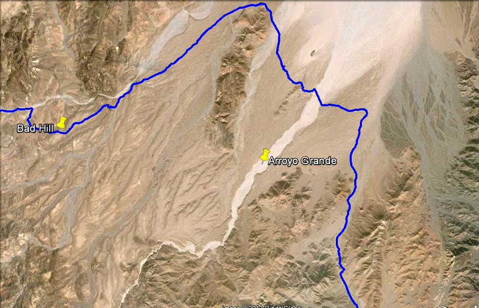
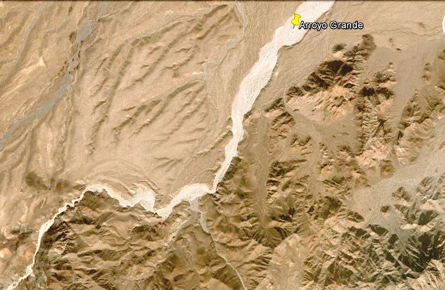
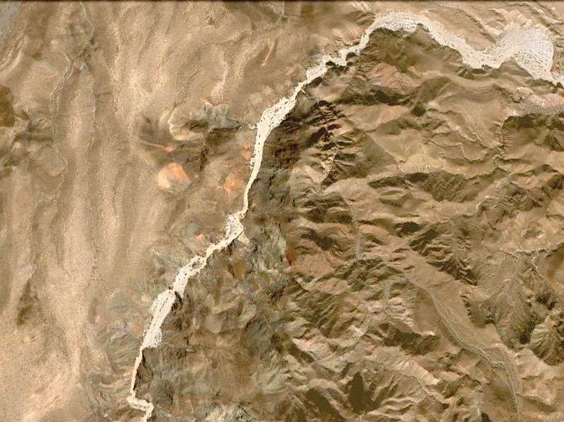
This bottom image is the canyon part of Arroyo Grande I would like to get into or see photos of...
Ken, in your Pole Line Road runs of the past, your GPS track or map you posted seems to leave the Pole Line Road west of Arroyo Grande and head north
to Ejido Saldaņa, then out to Hwy. 1? Thank you... Elizabeth and I tried to drive into the canyon a couple years ago, but a steel cable was stretched
across the arroyo just south of the Pole Line Road crossing and where the SCORE course climbed out heading south.
|
|
|
Ken Cooke
Elite Nomad
     
Posts: 8970
Registered: 2-9-2004
Location: Riverside, CA
Member Is Offline
Mood: Pole Line Road postponed due to injury
|
|
| Quote: | Originally posted by David K
Ken, in your Pole Line Road runs of the past, your GPS track or map you posted seems to leave the Pole Line Road west of Arroyo Grande and head north
to Ejido Saldaņa, then out to Hwy. 1? |
That's correct. There is a 'T' intersection where we travel north, drop into the arroyo and then onward to Ejido Saldaņa.
Dropping into the arroyo

|
|
|
David K
Honored Nomad
        
Posts: 65436
Registered: 8-30-2002
Location: San Diego County
Member Is Offline
Mood: Have Baja Fever
|
|
What Arroyo are you dropping into between the T intersection and Ej. Saldaņa? Jaquegel?
[Edited on 12-12-2013 by David K]
|
|
|
Neal Johns
Super Nomad
   
Posts: 1687
Registered: 10-31-2002
Location: Lytle Creek, CA
Member Is Offline
Mood: In love!
|
|
The conditions of Arroyo Grande change over the years.
In the 1980 there was a cable a couple of feet high across just south of the road crossing Arroyo Grande. Later you could drive all the way to Rancho
Grande. Sometime after that, the vegetation was too thick to drive through. Still later there was a dam upstream that blocked travel, then the dam
washed out. Three or four years ago there was no nearby cable across south of where I crossed on the road. I have not been up Arroyo Grande south of
the road for ten years. Tomorrows condition?
Neal Johns 
My motto:
Never let a Dragon pass by without pulling its tail!
|
|
|
TMW
Select Nomad
      
Posts: 10659
Registered: 9-1-2003
Location: Bakersfield, CA
Member Is Offline
|
|
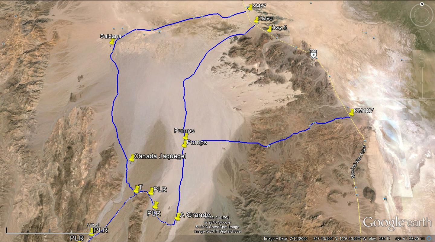
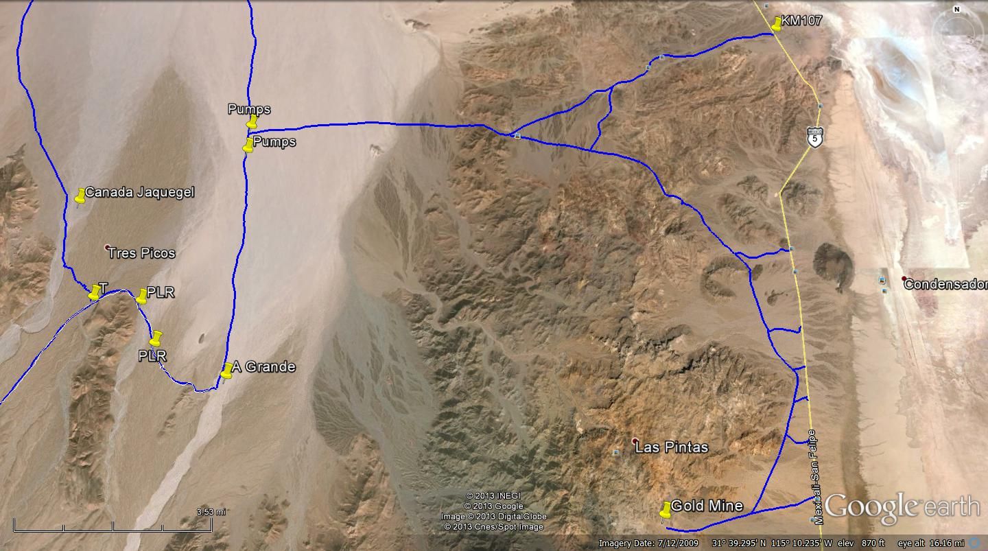
Perhaps this will make it more clear. Ken normally takes the route north at the T. Probably because the route over to A. Grande was washed out for a
couple of years or appeared to be until someone made a new climb out further east. In the 2007 run we took the route to A. Grande and out to KM90 on
hwy 1. As an FYI the pipe line has it's own road south with access to hwy 5 at a couple of places.
|
|
|
TMW
Select Nomad
      
Posts: 10659
Registered: 9-1-2003
Location: Bakersfield, CA
Member Is Offline
|
|
|
|
|
David K
Honored Nomad
        
Posts: 65436
Registered: 8-30-2002
Location: San Diego County
Member Is Offline
Mood: Have Baja Fever
|
|
| Quote: | Originally posted by Neal Johns
The conditions of Arroyo Grande change over the years.
In the 1980 there was a cable a couple of feet high across just south of the road crossing Arroyo Grande. Later you could drive all the way to Rancho
Grande. Sometime after that, the vegetation was too thick to drive through. Still later there was a dam upstream that blocked travel, then the dam
washed out. Three or four years ago there was no nearby cable across south of where I crossed on the road. I have not been up Arroyo Grande south of
the road for ten years. Tomorrows condition?
Neal Johns  |
Nice to hear that I wasn't the only one with 'cable issues'!
|
|
|
David K
Honored Nomad
        
Posts: 65436
Registered: 8-30-2002
Location: San Diego County
Member Is Offline
Mood: Have Baja Fever
|
|
| Quote: | Originally posted by TW
Perhaps this will make it more clear. Ken normally takes the route north at the T. Probably because the route over to A. Grande was washed out for a
couple of years or appeared to be until someone made a new climb out further east. In the 2007 run we took the route to A. Grande and out to KM90 on
hwy 1. As an FYI the pipe line has it's own road south with access to hwy 5 at a couple of places.
 |
Thanks Tom... We drove from K107 (La Ventana) jcn. west to the 'pumps' (wells), then south in Arroyo Grande (also the SCORE course here) to the Pole
Line Road (PLR), just south of your pin 'A Grande'... that is where a cable blocked any further progress south. We drove out of the arroyo on the PLR
southbound a couple of miles looking for another road back into A Grande, but no such luck.
As you have a T at Ken's T Junction, his group didn't come close to Arroyo Grande but instead went north in Caņada/ Arroyo Jaquegel. Thanks...
Now, still hoping for photos inside the canyon of Arroyo Grande, south of the Pole Line Road crossing! THANK YOU!
|
|
|
Ken Cooke
Elite Nomad
     
Posts: 8970
Registered: 2-9-2004
Location: Riverside, CA
Member Is Offline
Mood: Pole Line Road postponed due to injury
|
|
| Quote: | Originally posted by David K
As you have a T at Ken's T Junction, his group didn't come close to Arroyo Grande but instead went north in Caņada/ Arroyo Jaquegel. Thanks...
Now, still hoping for photos inside the canyon of Arroyo Grande, south of the Pole Line Road crossing! THANK YOU! |
This map made it much easier to see where I had traveled - not through the Arroyo Grande. You can see it south of the 'Bad Hill', but I have not
photographed it. From the 'Bad Hill' you can see the deep fissure of an arroyo.
|
|
|
David K
Honored Nomad
        
Posts: 65436
Registered: 8-30-2002
Location: San Diego County
Member Is Offline
Mood: Have Baja Fever
|
|
10-4   
|
|
|
TMW
Select Nomad
      
Posts: 10659
Registered: 9-1-2003
Location: Bakersfield, CA
Member Is Offline
|
|
Maybe I'll head down over New Years and take some pictures of Arroyo Grande. I have been past the dam but that was 6-8 years ago.
|
|
|
| Pages:
1
2
3 |

